
INTRODUCTION
Tourism is not only for improving the economy and community welfare, but also important for sustainability of culture, tradition, and custom. This article discusses about geotourism in Cimenyan Sub-districts – Bandung Regency. According to Regional Regulation of Bandung Regency Number 18 on Rencana Induk Pembangunan Kepariwisataan Daerah 2012-2017, the vision of Bandung Regency tourism development is the realization as a nature agrotourism destination and culture.
There are hills in Cimenyan-Cilengkrang as a main theme of geotourism, with vegetable agrotourism as its supporting theme. Geotourism is primarly on geological phenomena, where the objective of the trip is to visit and view a geological attraction. Where fossils are involved, an extension into early evolutionary processes and the evolution of humans (anthropology) and other vertebrates can also fall under the umbrella of geotourism (Dowling & Newsome, 2006). Lembang fault is one of the most interesting geological landmarks in highland of Bandung, and clear geomorphology expression of nontectonic activity in the Bandung Basin (Brahmantyo & Bachtiar, 2009). Lembang fault is a normal fault which crack along 22 km. It started from Mount Manglayang on the east and disappeared before the limestone hills of Padalarang on the west. Along the crack, it has geological phenomena can be interpreted. The presence of geological sites Lembang Fault can be utilized for geotrail planning as one way to improve education and develop tourism facilities which support the geotrail activities, and also as one way to promote geotourism products.
LITERATURE REVIEW
Trail design is one of the most important factors to insure that the route offers optimum scenic, geologic, historic, cultural and biological sites to provide a variety of diverse habitats for the trail user to experience. Trail design is the critical connection to make the trail sustainable, to reduce impacts to the natural environment, and to minimize future trail maintenance (Tennessee Department of Environment and Conservation, 2007).
* lutfiant11ersa@gmail.com
62 1 School of Architechture, Planning, Policy, and Development Bandung Institute of Technology
The design of a trail system begins with sound planning, consisting of the following steps (DCNR-Department of Conservation and Natural Resources Pennsylvania):
- 1. Reviewing relevant state, regional, and local planning efforts
- 2. Selecting a qualified trail designer
- 3. Engaging the public
- 4. Identifying the needs, wants, and concerns of the land manager, property owner, and adjacent neighbour(s)
- 5. Identifying the needs, wants, and desires of trail users
- 6. Assembling the mapping
- 7. Analysing the property to identify opportunities and constraints for developing your trail
- 8. Determining the type of trail system and level of difficulty
- 9. Determining the locations of potential trailheads
- 10. Determining regulatory requirements
- 11. Identifying environmental and cultural resources
- 12. Planning for accessibility
- 13. Establishing the preliminary trail alignment
- 14. Evaluating potential management structures for management, maintenance, and operations of your trail
- 15. Planning for management, maintenance, operation, and construction costs
- 16. Securing funding for trail planning, design, construction & maintenance
Planning is a second phase in the process and comprises sub-phases that fulfill the ecological, psychological and physical requirements of trails and their consumers. First among these is the collection of ad hoc data. Maps, literature about the place and interviews with landowners are all important in helping to develop the social and physical aspects of trail corridors. Proximity to water, distances from population centers, microclimates and access to roads and highways should be assessed through ad hoc data. For ecotrails and other nature-based routes, it is critical to understand the area's physical geography, natural vegetation, slope stability, potential for erosion and native wildlife. For a trail to be truly sustainable, sensitive areas must be identified. Swamps, steep gradients, endangered species habitats, sand dunes, remnants of material culture and other fragile ecosystems and potential resources must be identified (Timothy & Boyd, 2015).
METHODOLOGY
This article is using a mix method approach between qualitative and quantitative. Qualitative approach is used to describe supply analysis and spatial analysis of the study area. Spatial analysis helps to analyse the topography, land use, and prone of land movement areas. Thus, the result is synthesized using ArcGIS 10.2 software to find the suitable area and not. Therefore the zonation can be determined. Meanwhile, quantitative approach is used for demand analysis by processing questionnaires which distributed to visitors. The tools for processing data and obtaining calculation is using Microsoft Excel and SPSS 23.
Qualitative data collection technique is done by field observation using GPS as device to find out and save the route that has been passed, and also by semi-structured interview with interview instructions.
STUDY AREA
Bandung Regency has 176.238,67 ha area, consisting of 31 sub-districts, 267 villages, and 9 urban villages. According to its administrative location, Bandung Regency is adjacent to:
North : West Bandung Regency, Bandung City, and Sumedang Regency
East : Sumedang Regency and Garut Regency South : Garut Regency and Cianjur Regency
West : West Bandung Regency, Bandung City, and Cimahi City
Geographical location of Bandung Regency is in the eastern and southern parts of Bandung Basin which is an ancient lake basin contain sediments from volcanic sources. One of the interesting landmarks of the geological process is Lembang Fault, and some of the Lembang Fault line is located in Cimenyan Sub-district. Geographically Cimenyan Sub-district is a hilly area with altitude of 700-1.200 meters above sea level. It has a beautiful panorama and a big area of horticultural farm. There are several tourist attractions within the study area. The scope of the study area takes three villages within the Cimenyan Sub-district where the Lembang Fault line is located. There are Ciburial village with Tebing Keraton, Cimenyan village with Puncak Bintang and Caringin Tilu, and Mekarmanik village with Oray Tapa as tourist attractions.
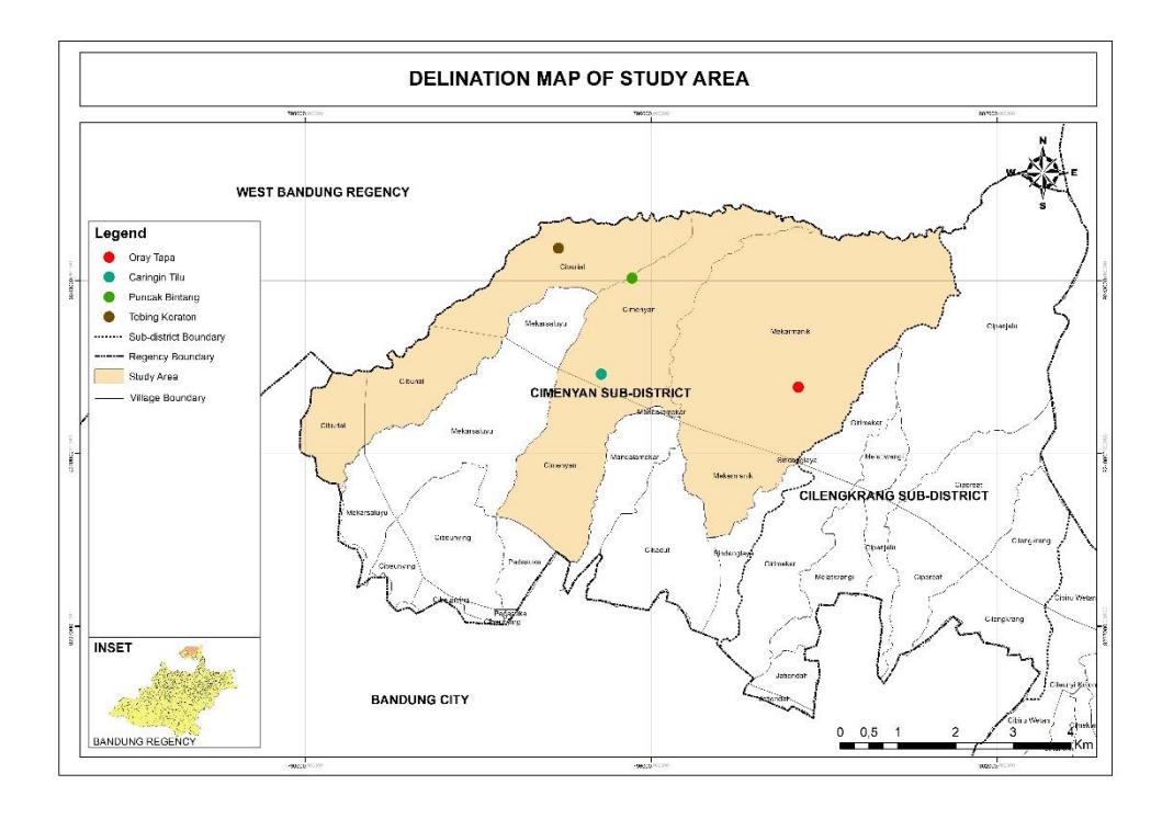
Figure 1 Delineation Map of Study area
DISCUSSION
Topography and Slope
The study area is located on a hilly with an altitude range of 775 meters above sea level up to 1.690 meters above sea level. The steep slope makes difficult for construction of structures and infrastucture, such as transportation facilities and supporting tourism facilities. Although it is difficult to develop, steep slopes provide another advantages such as providing distinctive and interesting sights for tourists. Slope classification in study area is classified based on Surat Keputusan Menteri Pertanian Nomor: 837/Kpts/Um/11/1980. The slope classification criteria listed in table 1.
Table 1 Slope Classification
| No. | Slope | Description |
|---|---|---|
| 1. | 0-8% | Flat |
| 2. | 8-15% | Sloping |
| 3. | 15-25% | Rather steep |
| 4. | 25-45% | Steep |
| 5. | >45% | Very steep |
Based on the North Country National Scenic Trail (1966) about the theory of trail slope standards, the trail should be designed with gradual level changes and preferably in the slope of 0%-30%. According to that literature,it can categorize slope suitability for climbing into three categories, which are suitable between 0-8% and 8-15%, rather suitable between 15-25% and 25-45%, and not suitable on >45%. The slope suitable for climbing is listed in table 2.
Table 2 Slope Suitable for Climbing in Study Area
| No. | Slope for Trail | Wide (ha) | ||
|---|---|---|---|---|
| 1. | Suitable | 505 | ||
| 2. | Rather Suitable | 2.508 | ||
| 3. | Not Suitable | 258 | ||
| Total | 3.271 | |||
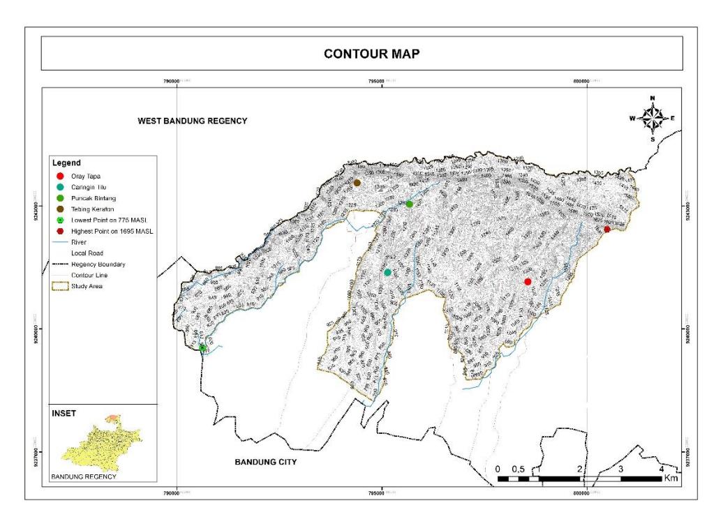
Figure 2 Contour Map of Study Area
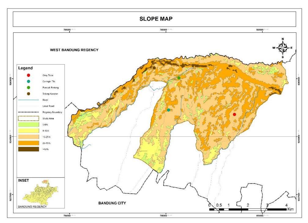
Figure 3 Slope Map
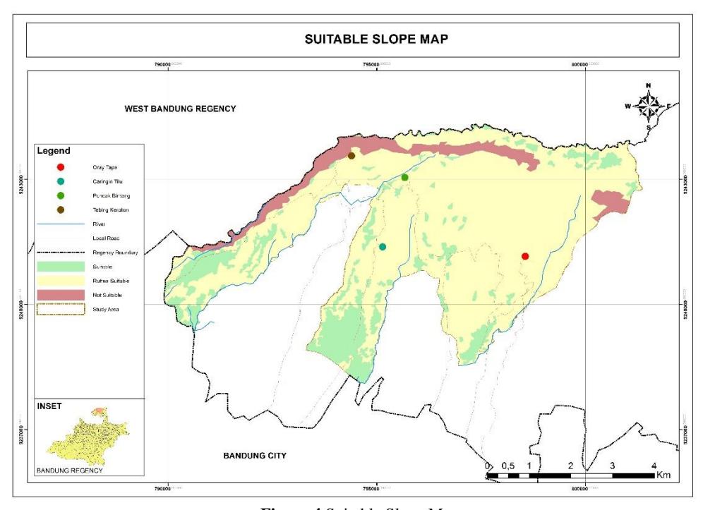
Figure 4 Suitable Slope Map
The high land movement is located along Lembang Fault which become a protected area. It is functioned as a conservation and protection forest under management of PT. Perum Perhutani and Balai Pengelolaan Taman Hutan Raya Djuanda.
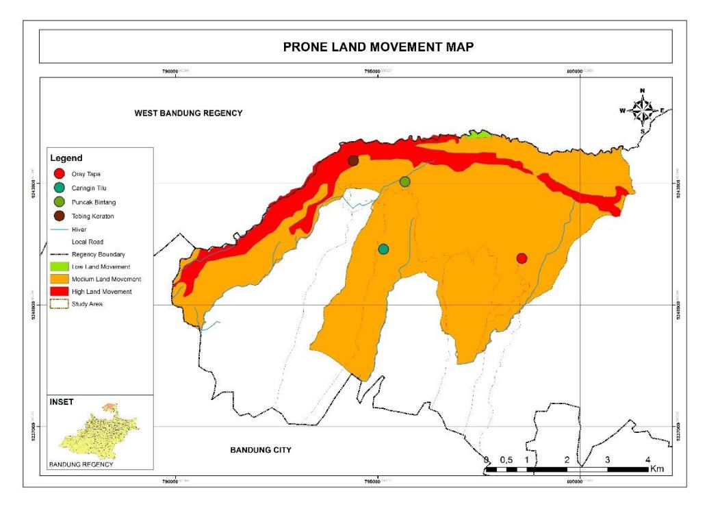
Figure 5 Prone Land Movement Map
Land Use
Allocation of land in Cimenyan geotrail area consists of protected forests, conservation forest, dryland farming, community forest, annual farming, wetland farming, production forest, and settlement area. Land use arrangements are required primarily because of the presence of hazard prone area and protected area, hence it can consider which area suitable for urban or settlement development. The land use for Cimenyan geotourism area is dominated by protection forest and dryland farming. The conservation forest is located in Taman Hutan Raya Ir. H. Djuanda area, which dominated by pine merkusii for its high plants and moss and fern for its low plants.
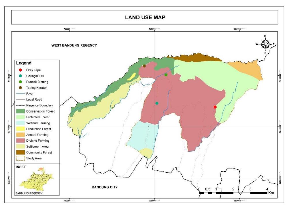
Figure 6 Land Use Map
Summary of Visitors Questionnaire Result
The questionaire is distributed to 100 visitors as a respondents to complete the form about visitor motivation in Cimenyan geotourism area. The scores show level of arguments which are (1) strongly disagree, (2) disagree, (3) netral, (4) agree, and (5) strongly agree.
Table 3 Tourist Motivation
| Percentage Assesment | ||||||
|---|---|---|---|---|---|---|
| No. | Motivation | 1 | 2 | 3 | 4 | 5 |
| 1. | To learn about nature including geology | 21% | 15% | 18% | 31% | 15% |
| 2. | To refresh and have a rest | 1% | - | 1% | 17% | 81% |
| 3. | To get out from daily routine | 1% | - | 7% | 27% | 65% |
| 4. | To be satisfied (self-esteem) for having reached/tracked the Lembang Fault | 3% | 16% | 29% | 30% | 22% |
| 5. | Because of the attractiveness of the landscape | - | 3% | 11% | 40% | 46% |
| 6. | To meet people who have the same hobbies and interests | 29% | 23% | 20% | 15% | 13% |
| 7. | I don't really care about geotourism here | 12% | 28% | 24% | 18% | 18% |
| 8. | To do sport activities such as hiking/walking/bicycling | 32% | 21% | 9% | 20% | 18% |
Based on the respondents' answers, it can be concluded that the motivation of the visitors is mostly about recreation and mind refreshment. While the respond about motivation related to the geology is vary. However, all visitors has felt the attractivenes of the landscape in geotourism area.
After analyzing the contour of the area, slope suitability, and prone of the movement, the maps are overlayed to obtain composite map which is the combined result of the whole map. The synthesis product is the spatial plan and circulation plan.
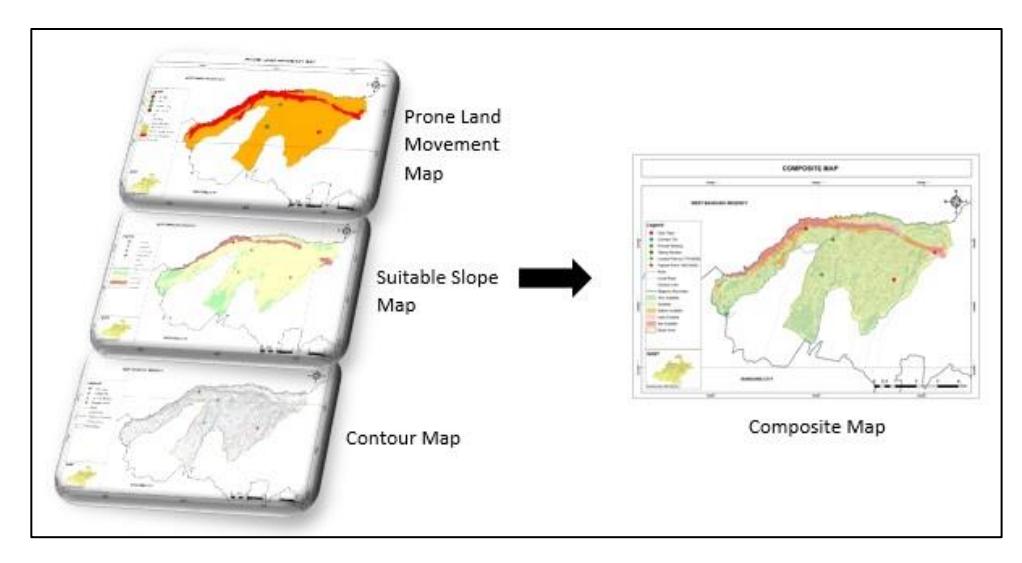
Figure 8 Overlay Scheme Process
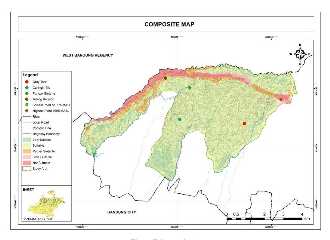
Figure 7 Composite Map
Zoning
The next step is to overlay composite map with land use map. Thus, there are three development zones, namely conservation zones, buffer zones, and other zones.
1. Conservation zone
The conservation zone is a core zone as a protected area because most of the region has topography which is steep to very steep or with a slope above 45%.
2. Buffer Zone
Buffer zone is the area surrounding or adjacent to the core zone, which has the primary purpose to protect the conservation zone. The buffer zone is developed into areas for trekking, wildlife and vegetation observation, natural exploration, and photography.
3. Other zone
Other zone is the outer and largest area that surrounding or adjacent to the buffer zone. This area is used for agriculture, settlements, and other types of utilization.
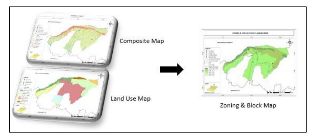
Figure 9 Overlay of Zoning Block Scheme Process Map
Circulation Concept
Circulation of geotrail planning in Cimenyan Sub-district is differentiated to primary and secondary circulation. The primary one is used for motor vehicles and cyclist user, while the secondary one is used for walking or hiking trail. The bike trail is conceptualized to accommodate visitors who like riding a bike in Cimenyan Geotourism Area, especially in the weekend. While the walking trail is conceptualized by utilizing the path that has been used by local communities.
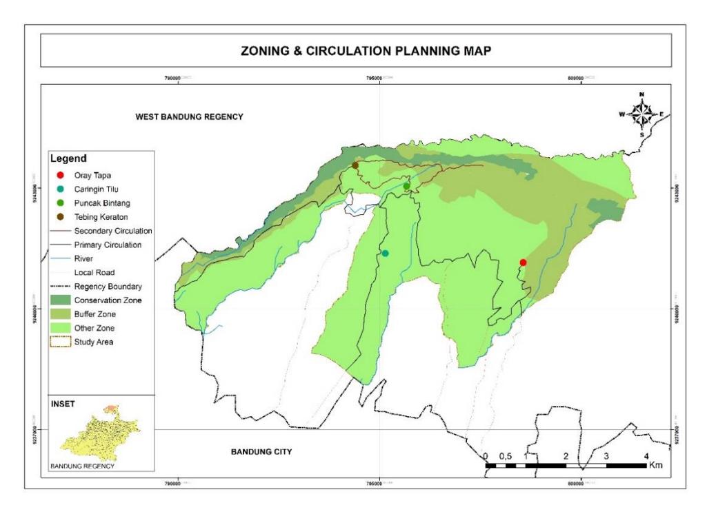
Figure 10 Zoning and Circulation Planning Map
Hiking Trail Design
The whole length of hiking trail along Lembang Fault is 7,6 kms with an estimated time around 4 hours. There are 8 corridors with different trail levels. Easy level on trail corridors number 4, 5, and 7 with trail width ±2 m and slope between 10%-25%. Middle level on trail corridors number 3, 6, 8 with trail width ±120 cm - ±250 cm and slope between 25%-30%. Difficult level on trail corridors number 1 and 2 with trail width ±40cm - ±120 cm and slope between 25%-30%, more details are listed in table 3 and figure 11.
Table 4 Geotrail Classification on Secondary Trail
| No. | Item | Description | |
|---|---|---|---|
| Easy Level Trail | |||
| 1. | User | Suitable for teens, families, elderly, and beginners | |
| 2. | Corridor | Corridor trail number 4 | |
| Corridor trail number 5 | |||
| Corridor trail number 7 | |||
| 3. | Length | Corridor trail number 4 508 m | |
| Corridor trail number 5 888 m | |||
| Corridor trail number 71.086 m | |||
| 4. | Width | ±2 m | |
| 5. | Slope | Corridor trail number 4 and 5 stable on the slope of rather steep slope (10% | |
| slope). | |||
| Corridor trail number 7 on flat to rather steep (25% slope). | |||
| Medium Level Trail | |||
| 1. | User | Suitable for individuals or groups seeking a moderate level of skill and fitness. | |
| 2. | Corridor | Corridor trail number 3 | |
| No. | Item | Description | ||
|---|---|---|---|---|
| Corridor trail number 6 | ||||
| Corridor trail number 8 | ||||
| 3. | Length | Corridor trail number 3 1.087 m | ||
| Corridor trail number 6 550 m | ||||
| Corridor trail number 8 940 m | ||||
| 4. | Width | ±120 cm - ±250 cm | ||
| 5. | Slope | Gradient of corridor trail number 3 is flat, rather steep to steep (25% to 30% | ||
| slope) | ||||
| Gradient of corridor trail number 6 and 8 is rather steep and steep (30% slope) | ||||
| Hard Level Trail | ||||
| 1. | User | Most suitable for small groups with range of age young adult to adult. Users will | ||
| feel challenge and train resistance in climbing. | ||||
| 2. | Corridor | Corridor trail number 1 | ||
| Corridor trail number 2 | ||||
| 3. | Length | Corridor trail number 1 1.413 m | ||
| Corridor trail number 2 1.116 m | ||||
| 4. | Width | ±40 cm - ±120 cm | ||
| 5. | Slope | Gradient of corridor trail number 1 is rather steep and steep (30% slope) | ||
| Gradient of corridor trail number 1 is flat, rather steep to steep (25%-30% slope) | ||||
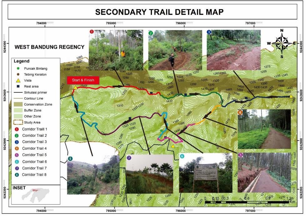
Figure 11 Secondary Trail Detail Map
CONCLUSION
Geotrail planning concept is a circulation planning concept, as a way to create educational activities. Potential Lembang Fault geological sites in Cimenyan Sub-district can be learned by visitors using 8 corridors trail. From the result of visitors questionairre, which they have interest to do geotourism activities. Thus, the visitors is possible to take the geotrail. The whole length of hiking trail along Lembang Fault is 7,6 kms with an estimated time around 4 hours. The level trail is divided into three: (1) easy trail level on corridors number 4, 5, and 7, (2)
medium trail level on corridors 3, 6, and 8, (3) hard level trail on corridors 1 and 2. Especilally in the corridor number 1, 2, and 3 which is along the Lembang Fault line.