
1. Introduction
South Sulawesi's territorial waters are suspected of containing submerged treasures dating from the 17th century to the Second World War, which are dispersed across 20 sites, one of which is in Bontosikutu District, Selayar Islands Regency. The site is located in Tile-Tile waters south of the Padang Canal at coordinates 6⁰14' LS and 120⁰25' LT. In November 2004, a traditional diving fisherman named Daeng Massinna identified the spot. Based on the Ship's Cargo Sank (Barang Muatan Kapal Tenggelam) Site Observation Activity Report, Selayar Regency, South Sulawesi Province, June 2, 2005. According to the Confidential Report, the South Sulawesi Cultural Heritage Preservation Agency has received reports of cases of illegal removal three times, in 2009, 2010, and 2017, but there is a high probability that objects resulting from illegal removals are sold freely, causing information about this site to spread among Jakarta antiquities collectors and looters.
This suggests that the intermediaries' network has expanded to include Selayar. If this trend continues, we are concerned that the site will be robbed shortly, and that historical evidence for Selayar Islands Regency as a commercial route for the archipelago will disappear. The history of trade in this regency inspired the name "Selayar," which is derived from the Sanskrit word cendaya (meaning one screen) because it is reported that numerous one-screen boats stop by this island. In the fourteenth century, the Selayar Islands Regency served as a trading route to the spice capital of Moluccan (Maluku). Traders visit the Selayar Islands to replenish supplies while they wait for a good season to resume sailing. This is evidenced by the presence of underwater archeological sites in Selayar in the form of shipwrecks or shipwreck cargo such as ceramics and cash coins. According to local information and consensus, the place is known as the Bontosikuyu Site. Furthermore, the Selayar Islands Regency has a distinct nautical identity because it is the only one whose jurisdiction is separated from the mainland of Sulawesi Island due to its location on small islands. Of course, one of the most important aspects is to preserve the maritime cultural legacy.
Thus, the explanation above indicates the enormous potential for marine heritage in the Selayar Islands from underwater relics; yet, it is threatened by misuse by the local people as a result of the unlawful collection of underwater cultural pieces for economic gain. If allowed unchecked, it will lead to the extinction of submerged cultural heritage objects, even though this possibility exists in various sites across the world. Therefore, it is believed that tourism would retain this potential. This motivated the author to conduct research utilizing the 3A approach to identify possible maritime heritage development sites and assess their readiness in light of current conditions. So, the title of the research is a spatial qualitative analysis of the marine heritage tourism in Bontoharu-Bontosikuyu District, the Selayar Regency. This study aims to identify the potential of travel pattern thematic "marine heritage tourism" as a means of enhancing tourism and as a conservation of marine heritage in the Selayar Regency.
2. Literature Review
Epistemologically, tourism with a systems approach emphasizes that the mobility of visitors, the community activities that facilitate it, and the ramifications for community life at large are all interconnected. Every tourist movement is accompanied by the provision of tourist amenities, and the interplay between the two has logical repercussions in the economic, social, cultural, ecological, and even political fields. The next method is the institutional approach. This viewpoint regards tourism as the product of institutional collaboration among many players (stakeholders) (McIntosh, Goeldner, & Ritchie, 1995). Every tourist journey includes tourists, transportation service providers, lodging providers, attraction services, and so on. They have a functional interaction with each other, which allows for tourist travel activities. Tourism, as a service commodity, can also be regarded via a product-oriented lens. This suggests that tourism was purposefully developed to meet community needs (McIntosh, Goeldner, and Ritchie, 1995). The idea of "Multiple A" (Attraction, Amenities, Accessibility), which is used to explain tourism product aspects, relates to the consequences of activities creating and/or reproducing commodities purchased by tourists.
Marine heritage includes historical, cultural, and archeological resources in coastal, marine, or lake contexts. It covers a wide range of historical periods, from native Indonesian seafarers to European colonial exploration in Asia and the current age. To be classified as a maritime heritage resource, an object must be at least 50 years old and have historical, cultural, archeological, or paleontological value. Cultural conservation is the preservation of cultural heritage, such as cultural conservation sites and cultural conservation areas on land and/or in the air, because they have important historical, scientific, educational, religious, and/or cultural values that must be determined. Coastal and maritime cultural heritage (CMCH) is a valuable resource in coastal communities. However, this heritage has faced several natural and human-caused dangers. One of its purposes is to bring it closer to the tourism industry. Coastal and marine tourism is one of the most rapidly growing divisions of the worldwide tourism business.
The mention of the historical and persistent relationship between human society and the waters, as well as the recognition of the significance of this relationship's physical footprint, are fundamental to the sea's cultural legacy. For example, in the foreword to a recent fundamental work on maritime archeology, Catsambis, Ford, and Hamilton wrote: "The sea is arguably the biggest border that humanity has ever seen throughout much of history. As a result, the perpetual relationship between humanity and the 'dark-wine sea' is inextricably linked with what it means to be human" (2013, p. xiii). Bass, maybe imprecisely, argues, "The importance of maritime culture to human history is obvious" and goes on to describe the global effect of boats, maritime workers, ports, and villages (2013, p. 3). As Bass suggests, maritime archeology is a tug-of-war between human activity on the sea surface and the physical qualities of the ocean as volume, depth, and motion—a relationship that is missing from much social science scholarly work on maritime history and culture (Steinberg 2013). The concept of marine cultural legacy also suggests that the interaction between humans and the water can be partially read in the remnants of material and/or discursive traditions. Furthermore, the usage of "heritage" rather than "history" implies that these links are still fluid and dynamic, and their relevance is in the public domain rather than the purview of academic historians. Rassool (2000) investigates the significance of the distinction between history and inheritance. Unfortunately, the coastal environment's highly dynamic nature is easily challenged by any sort of development, with serious long-term effects (Stewart & Draper, 2006).
Tourist destinations are a combination of attractions, housing, and supporting amenities offered in a community life structure that adheres to relevant processes and customs (Kemenparekraf, 2020). To be recognized as a tourist village, a location must meet the following criteria tourist attractions encompass nature, culture, and human creation. The picked attractions are the most intriguing and appealing in the village; distance traveled refers to the distance from tourist attractions, as well as the province and district capitals; village size refers to the number of dwellings, population, and area of the village. This criterion relates to a village's tourism carrying capacity; belief systems and society play a significant role in village communities, which have unique regulations (Ningrum et al, 2018), The dominant religion and the prevailing social system must be considered; and infrastructure availability includes transportation, electricity, potable water, drainage, and telephones.
In theory, a cluster can be characterized as a geographic concentration of business components and institutions working in a specific or specified field that serves as the main product (core product). In this regard, the cluster approach to developing tourism destinations has primarily focused on improving the quality of performance of relationships between related business chains and other supporting systems, thereby increasing the destination area's effectiveness and competitiveness. In terms of tourist industry development, the tourism cluster components that will synergize contain at least the following factors (Sunaryo, 2013), there are tourist attractions (natural, cultural, or of special interest); supporting infrastructure/amenities (hotels, entertainment, shopping, tour operators, travel agents, airlines, restaurants, and product suppliers); Human resources preparation institutions, such as universities, tourist colleges, and training institutions; Public and private sector institutions, both government and regional/local; and local communities serve as hosts.
3. Methodology
The technique is based on the scientific availability of the third type of social humanities, which is research design and methodology. This study adopts a spatial qualitative technique, namely a method that combines direct observation and geographical data analysis (Prominski, 2017) through mapping programs (such as ArchGIS). Qualitative research uses an observational approach, and the research instruments are a list of interviews, field observations, and literature studies, with tourist destination theory and tourism development theory serving as the foundations (Sulistiyono, 2017). The data analyzed includes both primary data namely observations and secondary data (literature research). This study also includes stakeholder perspectives (consisting of village officials, the local people, and the head of the Tourism Officer in Selayar Regency) on location determination, as well as direct observations at several points, to obtain a balanced view of the future economic, environmental, and social development of coastal and marine tourism (Zheng, 2017), which is divided into several categories using the 3A approach, namely attractiveness, accommodation, and accessibility in and out of the destination.
The qualitative spatial stage of this research begins with determining the target location points for the maritime heritage path based on literature reviews and stakeholder consultations. Second, record observations by dropping the location into the ArcGIS application. Third, conduct focus group discussions (FGDs) with stakeholders to identify indicators for each element based on field conditions. The findings of this research were applied to ArcGIS, which revealed spatial groups at each site. This information is required to establish alternate tourist routes and travel patterns.
The research is planned to identify marine heritage tourism potentials using spatial visualization using ArcGIS, with a focus on potential tourist attractions, accessibility conditions, and the availability of services near tourist locations. From July to October 2022, the researchers conducted their investigation in the Bontosikuyu District and nearby parts of the Selayar Islands Regency. The researchers eventually conducted firsthand surveys on several islands that include maritime historical sites.
4. General Description of the Research Location
The Selayar Islands Regency, known for its copra commodity and strategic location, was formerly a trade route. Indeed, it still plays an essential role in trade today. Unexpectedly, Selayar Islands Regency has several maritime heritage tourist attractions. The bulk of these dive sites are still considered tourist resources and must be developed before visitors can visit.
In the fourteenth century, the Selayar Islands Regency served as a trading route to the spice capital of Moluccan (Maluku). Traders visit the Selayar Islands to replenish supplies while they wait for a good season to resume sailing. The name Selayar originated from this cruise activity. The name Selayar is derived from the Sanskrit word cendaya, which means one screen, as many one-screen boats are supposed to stop at this island. Aside from the name Selayar, this island is also known as Tana Doang, which translates to "land of prayer." Selayar Island was once a site of prayer for sailors who sought to continue their journeys both west and east to ensure their safety. Amanna Gappa's (17th century) treatise of legislation on shipping and trade refers to Selayar as a trading destination due to its strategic location as a transit point for both east and west ships. The text states that the rent for passengers sailing from Makassar to Selayar, Malacca, and Johor is 6 rials per hundred people.
Bontosikuyu District is located in the southern portion of Selayar Island, comprises three communities on a tiny island, and covers the largest area in Selayar Islands Regency. This position provides Bontosikuyu District with a diverse range of natural resources, both on land and at sea. According to the findings of the Bontosikuyu Waters Site Excavation Rescue Underwater Cultural Heritage Report in 2021, this area was formerly a major transit route for internal and international trade. The strategic location that connects the Australian and Asian continents attracts many domestic and international merchants to cruise. This is reinforced by the discovery of a shipwreck beneath the water in Bontosikuyu District. The Cultural Heritage Center in Selayar Regency has been recorded as conducting 3-4 legitimate excavations, whereas the local community has conducted many unlawful excavations. The findings led to the creation of porcelain and stoneware ceramics with floral, geometric, and geometric motifs, as well as Chinese coins used as a means of exchange. Meanwhile, the Bontoharu District, which borders the Bontosikuyu District, is an additional place. This is because subsequent observation and literature analysis revealed that the area had thematic potential for marine heritage tourism.
5. Discussion
Dong Zhiwen and Zhang Guanghai (2004) emphasized the need to deeply excavate the characteristics and meanings of marine culture, as well as emphasize the cultural heritage of tourism products, in the development of marine cultural tourism. Zhang Yanqing, Ma Bo, and Fan Yingjie (2017) considered an increasingly developed domestic economy and a consistently improving standard of living. A coastal and marine destination can be viewed as a collection of consumption experiences or as "a series of inter-connected sub-systems that co-exist and offer diverse social and cultural forms to a range of different market segments" (Carlisle et al., 2016, pp. 86-87). Coastal tourism is heavily reliant on favorable ecological conditions and high water quality. Any maritime or land-based activity that degrades the environment might harm tourism (European Commission, 2019).
Archaeological investigation and documentation of cultural materials can help to preserve marine heritage for future generations. Based on a literature search, the Makassar Archaeological Heritage Preservation Center (Currently known as the South Sulawesi Cultural Heritage Preservation Center) has been doing underwater archaeological research in this area since 2003. In the coming years, this institute, which is part of the Ministry of Education, Culture, Research, and Technology, will perform research in the Selayar seas. The Bonto Sikuyu Site underwent a survey and exploration in 2008, followed by a collection update and zoning analysis in 2009. Then, in 2019, excavation efforts were carried out at the Bonto Sikuyu Site, and in 2021, a survey was conducted in the waters of Pasi Gusung Island.
According to the distribution map, the Kappala Taka, Bontosikuyu, and Taka Bajangan sites are located on Selayar Island's west side. The area is still used for cruise lines, both regional and interisland. Furthermore, of the three sites discovered, underwater archaeological remnants were uncovered on the west side of the gusung, or land, indicating that the catastrophe occurred during the west monsoon. Until now, cruise ship activities had been avoided in Selayar waters during that season. Previous studies have yielded ceramic findings. Ceramics was once a trading commodity; this activity was carried out by cruise ships and thus proves that the ship that sank in that area was part of a series of commercial activities. This is also significant evidence that the seas of Selayar Island are among the most popular cruise lines. The three places are described as follows:
Bontosikuyu Site
The Bontosikuyu Site is administratively located in Bontosikuyu District, between the villages of Harapan and Patikaraya. This location is 22 meters deep and located parallel to the mouth of the Bontosikuyu River. This site has archeological relics such as ceramics and coinage. Due to its proximity to residential areas, locals lifted the wrecked ship's cargo and sold it to antique collectors. Ceramic objects, including plates, bowls, cups, and jars, can be found on the seafloor or buried beneath mud. Meanwhile, there are hundreds of coins in the shape of Chinese money. Excavations to remove shipwreck cargo in the form of ceramics and coins, some of which have been housed in the Nekara Museum in Selayar.
Taka Kappala Site
Taka Kappala Site is administratively located in Tambolongang Village, Bontosikuyu District, to the west of Tambolongang Island. This site is at a depth of 6-8 meters with a visibility of 10 meters. In addition to the ship's archaeological objects, porcelain bits, coal, and bottle fragments composed of glass, wood, and rubber were discovered amidships at the former dig site. The ship's hull, which has been buried in sand, can be located in the middle and back of the excavation site. Furthermore, some iron plates were split into bits; iron plates are a component of the ship. The remaining hull measures 12 meters wide by 75 meters long. The shipwreck had suffered significant damage as a result of the iron leak. So far, these archaeological discoveries have been protected, although they are nonetheless restricted to archaeological study and excavation activities. The cultural heritage center office in Selayar requires permission, hence no tourists have ever reached that point.
Taka Bajangan Site
Taka Bajangan 1 is located 3.5 nautical miles west of Pasi Island, Bontoharu District, Selayar. This site is located at a depth of 5-6 meters, with visibility in the water ranging from 6 to 10 meters during the survey. The survey crew included an underwater team from the cultural heritage office and a diving instructor who was interested in ancient artifacts. The site contains four massive anchors and a cannon. The four anchors and cannon cover an area of 30 by 20 meters. The anchor has coral growing throughout, allowing the components to be identified, whereas the cannon is overgrown with coral, particularly at the front, where there is considerable coral overgrowth. To date, diving in this area has been conducted for study and cultural heritage preservation purposes. Not yet discussing tourism activities.
5.1. Analysis of Tourist Spots that have the potential to be used for Marine Heritage Tourism
The extra points shown on the tourism attraction and resource distribution map represent maritime tourism opportunities that can be linked to the packaging of marine heritage-themed tourism goods. This tendency has resulted in disparities in facilities and accessibility among the three settlements. Similarly, different tourism market categories are based on the attractiveness of the tourist village. This promotes the growth of tourism and public infrastructure in these three locations (Latif, 2018). There are 21 locations for marine heritage development as follows (Table 1).
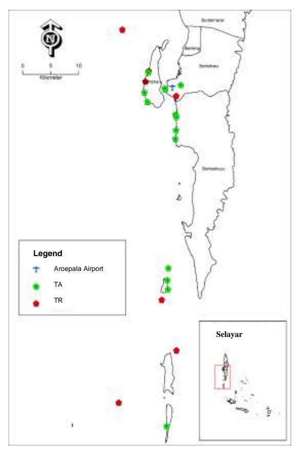
Figure 1. Maps of Tourism Attraction in Marine Heritage Trail, Bontosikuyu – Bontoharu Districts, Selayar Island
Table 1. Point of Location in Marine Heritage Trail, Bontosikuyu – Bontoharu Districts, Selayar Island
| No. | Point of Location | Status | Position | |
|---|---|---|---|---|
| 1. | Bahuluang Village | tourist attraction | Land | |
| 2. | Sunari Beach | tourist attraction | Land | |
| 3. | Quina Paradise Cottage Selayar | tourist attraction | Land | |
| 4. | The Norsyiah Villa | tourist attraction | Land | |
| 5. | Cantik Selayar Villa | tourist attraction | Land | |
| 6. | The Genos Villa | tourist attraction | Land | |
| 7. | Liang Kereta Resort | tourist attraction | Land | |
| 8. | Villa Arfang Arief Bahuluang | tourist attraction | Land | |
| 9. | Bukit Nane Pollasi | tourist attraction | Land | |
| 10. | Liang Tarrusu | tourist attraction | Land | |
| 11. | Kerang Bahuluang's Tomb | tourist attraction | Land | |
| 12. | Giant Anchor and Cannon Museum | tourist attraction | Land | |
| 13. | Anchor and Cannon Museum | tourist attraction | Land | |
| 14. | Bontosikuyu Site | tourist resource | Marine | |
| 15. | Diving Spot of Gusung Island | tourist resource | Marine | |
| 16. | Diving Spot of Bahuluang Island | tourist resource | Marine | |
| 17. | Takabajangan Site | tourist resource | Marine | |
| 18. | Taka Kappala Site | tourist resource | Marine | |
| 19. | Diving Spot of Bahuluang Island | tourist resource | Marine | |
| 20. | Diving Spot of Pulau Pollasi | tourist resource | Marine | |
| 21. | Balojaha Cave | tourist resource | Marine |
The chosen places contain both marine and cultural tourism attractions on land and in water. Location selection is based on the results of a literature analysis of locations that have maritime heritage diving spots according to data from the sub-district office; the office of the cultural heritage conservation center, previous research, and supporting papers. Aside from those that remain underwater, some marine historical treasures have been removed and protected by locals. Typically in the shape of compass points, fragments of ship hulls, and pottery and coins. Archaeological artifacts that have been taken are typically stored in museums as cultural tourist attractions. The rest are in adjacent settlements and serve as additional tourist attractions. Based on these criteria, the author has picked at least 13 spot locations on land and 8 at sea, as described in the table and figure above.
5.2. Analysis of Tourist Area Supporting Facilities or Amenities
Detail-oriented arrangement of physical qualities in public settings can bring comfort to a person, particularly when contextualized in tourism. The availability of supporting amenities and arrangements, such as arranging benches, providing restrooms, and bicycle racks, and using trees as shade, are examples of factors that can help a person form attachments to a location (Prominski, 2017; Aulia and Halim, 2020). The findings from interviews with several stakeholders highlight the importance of multi-stakeholder participation in tourism villages in Bontisikuyu District and surrounding areas. Because Selayar was formerly an international commerce route used by a variety of international businesses. Thus, several sunken ships and their cargo remain in the vicinity. Examples include anchors, cannons, ceramics, coinage, ship hulls, and more. Indicators of minimum supporting facilities in tourist areas according to Yoeti (2003), include accommodation (homestay, guest house, hotel, inn, or other types of accommodation); catering (restaurant, canteen, and café); shopping (souvenir sellers, and all-in-one shop); communication (internet signal, cell phone signal, and other telecommunications signals); health (health center, hospital, health post, etc); security (security post, security officer, Police station, etc); cleanliness (trash can, hygiene warning boards, and janitor); worship facilities (prayer room, mosque, chapel, church, etc); promotional (welcome monument, banner, billboard, brochure, etc); and tourist facilities (objects visited by nature, culture, and artificial). Referring to these criteria and the conditions of the tourist areas around Bontosikuyu and Bontoharu sub-districts, the author divides three criteria, namely high, medium, and low.
High : If the tourist area has 7-10 of the facilities mentioned Medium : If the tourist area has 4-6 of the facilities mentioned Low : If the tourist area has 0-3 of the facilities mentioned
The analysis carried out is related to the components of tourism, namely the availability of supporting facilities and accessibility which is illustrated in the following figure (Figure 2).
Figure 2. Availability of Supporting Facilities in Heritage Tourism Trail Bontoharu-Bontosikuyu District
Table 2. Availability of Supporting Facilities in Heritage Tourism Trail Bontoharu-Bontosikuyu District
| Information of Point | Availability of Facilities |
|---|---|
| Bahuluang Village | High |
| Sunari Beach | High |
| Liang Kereta Resort | High |
| Bukit Nane Pollasi | Low |
| Liang Tarrusu | Middle |
| Kerang Bahuluang's Tomb | High |
| Giant Anchor and Cannon Museum | High |
| Anchor and Cannon Museum | High |
| Bontosikuyu Site | Low |
| Diving Spot of Gusung Island | Low |
| Diving Spot of Bahuluang Island | Low |
| Takabajangan Site | Middle |
| Taka Kappala Site | Middle |
| Diving Spot of Bahuluang Island | Low |
| Diving Spot of Pollasi Island | Low |
| Balojaha Cave | Middle |
Based on the availability of facilities both within and beyond the area, the area remains highly constrained. This is because Selayar is an island with few public and social facilities. Tourist attractions, on the other hand, typically provide appropriate inside facilities to suit the needs of visitors. Tourists' frequent visits make management more receptive to their fundamental needs, such as toilets, prayer rooms, food and drink vendors, and selfie spaces. According to study results, Bahuluang Village has the largest distribution of facilities. This is because Bahuluang Village is one of the most popular tourist destinations in South Sulawesi. Additionally, the Sunari Beach area, as a comprehensive tourist attraction, provides restaurants/cafés and lodging based on the beauty of the beach. The next resort is Liang Kereta Resort, which is located on a tiny island. However, the area's facilities are pretty adequate, including bathrooms and a rinse room, housing, and the option to arrange meals and a bonfire.
Finally, there's the Anchor and Cannon Museum. This museum is easily accessible by land from Benteng City, Selayar. Several archeological finds have been removed and housed in museums, making this one of Selayar's most popular museums. Meanwhile, developing tourism destinations have modest facilities that require the development of 4-6 facility components, such as Takabajangan Island, Taka Kappala Island, Balojaha Cave, and Liang Tarussu. This is because they are still limited to the number of tourists who may visit to take photos/selfies. The dive sites are mainly near small islands, however, the facilities are extremely limited. For example, dive sites on the Bahuluang and Pollasi islands.
Analysis of the availability of tourism-related amenities is deemed crucial to determine how effectively these activities are carried out. The primary question about service is: what services and activities should be given to assist tourism? Because tourists are more inclined to visit a site that offers a wide range of tourist activities. As a result, while designing a vacation package, connectivity between activities and surrounding tourist destinations is essential. The activities offered at the chosen tourist destination can be used to create a theme path that connects the attractions of one object to those of others.
Aside from that, tourist destinations must have a positive impact on the local communities. So it is critical to maintain an area's sustainability as a result of tourism activity. As with an earlier study on tourism motivation, amid busy everyday chores, a person's urge to engage in social activities such as environmental protection, meeting friends, and socializing with others must be considered. (Carr 1992; McLaren 2000; Aulia and Halim 2020). Local communities in tourist destinations can help achieve this by participating in tourism planning and development. Good management can maximize a destination's benefits.
Furthermore, the packaged activities are designed to contain tasks that must be completed so that tourists leave with a pleasant image of their trip to that location. It should be noted that the marine heritage theme is a step theme that draws on underwater archaeological finding resources. Fortunately, Selayar possesses many of these resources, which must be used to their full potential. The marine heritage trail's thematic tourism promotion plan must also highlight the unique benefits of tourist visits. This can help to distinguish between maritime tourism and mass tourism. The uniqueness of a tourist destination, particularly one that focuses on marine tourism in conservation zones, gives an amazing experience due to the underwater beauty and geography of the area.
In addition to supporting amenities, accessibility is a crucial factor to consider. Accessibility can be perceived from the outside, specifically a person's travel from their point of origin to a tourist destination and back again. This is connected to road conditions and modes of transportation; and the internal side is access within the tourist attraction so that tourists can easily carry out tourist activities while in the area, such as road conditions, road signs, and so on. Most marine tourism visitors to Selayar agree that the range of tourists accessible on Selayar Island makes it simpler for tourists to visit and experience its influence. This is reinforced by research findings that suggest that marine tourism visitors consider the route's position to be easy for tourists to pass and is the center of tourist attention, as well as indicators indicating marine tourism spots are placed along the highway. In tourist destinations with limited accessibility such as Selayar Island, it is vital to reconsider how visitors can simply and comfortably access this method of transportation. Aside from that, the time it takes for tourists to get to a site is an important issue to consider. Because the longer it takes to get to a tourist spot, the more tourists are likely to be impressed. Based on these factors, the author classified them into three categories: high, medium, and low.
High` : a maximum travel time of 30 minutes from the airport, and public and private
transportation modes available
Medium : meaning the travel time from 30 to 60 minutes from the airport using land and sea
modes and having regular boat schedules available
Low : meaning it takes more than 60 minutes from the airport using land and sea modes.
It is difficult to reach by land and sea, and only private or chartered transportation is available
According to Soekadjo (2003), accessibility needs include access to information, easy-to-find and reach amenities, and passable road conditions to tourist attractions and destinations. However, these two types of transportation typically use a charter system rather than scheduled public transportation. If you wish to see this thematic area, you'll require a tour operator. Furthermore, certain dive sites are located far from Selayar Island, making the tour package more expensive than other tourist attractions. Figure 3 depicts the accessibility of a marine heritage-themed tourist destination in the Selayar Island area using the indicators determined as follows:
- a. Tourist attractions with high accessibility are those placed on land in Benteng City, Selayar. Because it may be accessed by land with a private or rented automobile on paved roads in decent condition. The tourist attractions in question are Sunari Resort, Villa Norsyiah, Villa Cantik Selayar, Anchor and Giant Cannon Museum, and Bontosikuyu Site.
- b. Tourist attractions with middle accessibility are those that are easily accessible by sea, as tourists can cross the island in fishing boats from Benteng City, Selayar, or Padang Village, Bontoharu District. Tourist attractions with medium accessibility include Quina Paradise Cottage, Ganos Villa, and Liang Kereta Resort; Gusung Island Diving Site; Takabajangan Site; Taka Kappala Site; and Balojaha Cave.
- c. Tourist sites with low accessibility are those that have a wide range of travel distances when combining land and maritime routes. Because Selayar Island is remote from urban areas, travel time is lengthy, with a minimum of 90 minutes by land and sea. In general, this tourist destination is located in Bontosikuyu District, which includes Bahuluang Village, Villa Arfang Arief Bahuluang, Liang Tarrusu, and Pollasi Island Diving Spot.
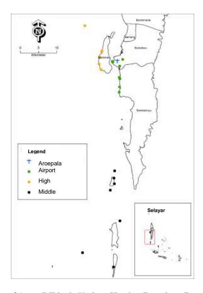
Figure 3. Availability of Accessibilities in Heritage Tourism Bontoharu-Bontosikuyu District
Table 3. Availability of Accessibilities in Heritage Tourism Bontoharu-Bontosikuyu District
| Information of Point | Availability of Accessibilities | |
|---|---|---|
| Bahuluang Village | Low | |
| Sunari Beach | High | |
| Quina Paradise Cottage Selayar | High | |
| The Norsyiah Villa | Low | |
| Cantik Selayar Villa | Low | |
| The Genos Villa | Middle | |
| Liang Kereta Resort | Middle | |
| Villa Arfang Arief Bahuluang | Low | |
| Bukit Nane Pollasi | Low | |
| Liang Tarrusu | Low | |
| Kerang Bahuluang's Tomb | Low | |
| Giant Anchor and Cannon Museum | High | |
| Anchor and Cannon Museum | Low | |
| Bontosikuyu Site | High | |
| Diving Spot of Gusung Island | Middle | |
| Diving Spot of Bahuluang Island | Low | |
| Takabajangan Site | Middle | |
| Taka Kappala Site | Middle | |
| Diving Spot of Bahuluang Island | Low | |
| Diving Spot of Pollasi Island | Low | |
| Balojaha Cave | Middle | |
6. Conclusion
Coastal and marine tourism is one of the fastest-expanding segments of the global tourism industry. Unfortunately, the extremely dynamic nature of the coastal environment is easily challenged by many forms of development, which have major long-term consequences (Varmer, 2006). The Selayar Islands Regency has a massive marine potential, both in terms of underwater habitats and marine heritage, that is rarely found elsewhere in the world. This allows for themed packaging of tourism products that not only focus on developing water areas but combine the potential of marine ecosystems with undersea archaeological remains. Of course, conservation, education, and outreach initiatives, as well as archaeological studies and recording, are required to protect maritime heritage for future generations via tourism.
The tourism industry may help safeguard and preserve maritime heritage for future generations by adopting a proactive conservation strategy and involving local communities in conservation activities. Tourism stakeholders (Sharma et al., 2019), including destination marketers, tourism organizations, and local governments, should identify many issues that influence tourists' emotional experiences, such as poor bathroom upkeep, marine life abuse, and tourism quality. Tourist assistance services include lodging, food and drink, and access to public and social facilities.
According to the findings of surveys and interviews with stakeholders, these 13 selected tourist destinations require further improvement in terms of tourism development. According to the 3A method, the natural beauty of both the land scenery and the undersea ecology drew the most attention. As a result, this tourist attraction remains authentic and popular with foreign tourists in general. However, there must be restrictions that limit tourism activities since this conduct causes negative emotions, which build undesired information, ideas, and attitudes in tourists and managers, resulting in a poor perception of tourism in conservation areas. As a result, resort planners must construct facilities and infrastructure that appeal to tourists (Chen and Tsai, 2007). If we look at the attractiveness components, we can see that certain areas remain popular tourist destinations, but the majority of them want improvement. One element is the availability of tourism support services on the island. The study's findings indicate that the availability of supporting amenities in tourist attraction locations is directly linked to the intensity of tourist visits. The more frequently and many people visit there, the more complete the supporting amenities will become. The majority of the supporting facilities are created using existing natural materials, which adds to the sense of authenticity. Meanwhile, getting to tourist destinations is often inexpensive via land and sea transportation. However, these two types of transportation typically use a charter system rather than scheduled public transportation. If you wish to see this thematic area, you'll require a tour operator. Furthermore, certain dive sites are located far from Selayar Island, making the tour package more expensive than other tourist attractions.
Overall, the spatial potential of marine heritage tourism packages is tremendous, but due to a lack of attention, it needs significant improvement and development in terms of attractions, accessibility, and performance.
Acknowledgments
Aqilah Nurul Khaerani Latif, et al., Universitas Hasanuddin, wrote this journal article based on the findings of a study titled "Marine Heritage Trail Packaging in Bontosikuyu District as a Leading Travel Pattern in Selayar Islands Regency," which was funded by a grant from Universitas Hasanuddin's Institute for Research and Community Service (LPPM) in 2021. The author is solely responsible for the contents.
References
- Arikunto, Suharasimi. (2010). Prosedur Penelitian Suatu Pendekatan Praktik. Jakarta: Rineka Cipta.
- Aulia, D. N. and Halim, Oki W. (2020). Study of Market Activities as Public Spaces on Planned Settlement (Case Study: Deli Indah Estate, Medan). IOP Conference Series: Earth and Environmental Science.
- Carlisle, S., Johansen, A., & Kunc, M. (2016). Strategic foresight for (coastal) urban tourism market complexity: The case of Bournemouth. Tourism Management, 54, 81–95.
- Carmona, Matthew, Tim Heath, Steve Tiesdell, and Taner Oc. (2010). Public Places, Urban Spaces: The Dimensions of Urban Design Second Edition. London: Routledge.
- Carr, S., Francis, M., Rivlin, L.G. and Stone, A.M. (1992). Public Space. Cambridge University Press, Cambridge.
- Chen, C.F. and Tsai, D. (2007). How do destination image and evaluative factors affect behavioral intentions? Tourism Management, 28(4), pp. 1115-1122.
- Dahuri, R. (2001). Integrated Management of Coastal and Ocean Resources (Pengelolaan Sumber Daya Wilayah Pesisir dan Lautan Secara Terpadu). Jakarta, Indonesia: Pradnya Paramita.
- Dimitrovski, Darko; Lemmetyinen, Arja; Nieminen, Lenita., and Pohjola, Tuomas. (2021). Understanding coastal and marine tourism sustainability - A multi-stakeholder analysis. Journal of Destination Marketing & Management, 19, 100554. DOI: 10.1016/j.jdmm.
- Dong, Z.W.; Zhang, G.H. (2004). Research on the Development of Marine Cultural Tourism Resources. Truth Seek., 4, 222–223. 2.
- Fistola, R. and La Rocca, R.A. (2017). Driving functions for urban sustainability: the double-edged nature of urban tourism. International Journal of Sustainable Development and Planning, 12(3), pp. 425-434.
- Gehl, Jan. (1987). Life Between Buildings: Using Public Space. Danish: Arkitektens Forlag.
- Gillian, Wallace dan Andrew Pussel. (2004). Eco-Cultural Tourism as a Means for the Sustainable Development of Culturally Marginal and Environ-mentally Sensitive Regions. Tourist Studies, 4(3), 235–254.
- Governor of Indonesia. (2010). Undang-Undang Nomor 11 Tahun 2010 Tentang Cagar Budaya.
- Governer of South Sulawesi. (2021). Excavation Report Rescuing Underwater Cultural Heritage Remains at Bonto Sikuyu Aquatic Site, Selayar Regency (Laporan Ekskavasi Penyelamatan Tinggalan Cagar Budaya Bawah Air Situs Perairan Bonto Sikuyu, Kabupaten Selayar).
- Hartoyo, H. dan Santoni. (2018). Kalijodo Public Space Criteria Supporting Accessibility and Increasing Activities (Kriteria Ruang Publik Kalijodo Pendukung Aksesibilitas dan Peningkatan Aktivitas). Jurnal Teknik Arsitektur ARTEKS, 2(2). ISSN 2541-0598.
- Ministry Tourism and Creative Economy of Indonesia. (2020). Panduan Desa Wisata. DKI Jakarta.
- Kotler, P., Bowen, J., Makens, J. C. (1996). Marketing for hospital and tourism. New Jersey: Prentice
- Hall. (2000). The Mountain Institute, Community Based Tourism for Conservation and Development: A Resource Kit. The Mountain Institute Washington D.C.: USA
- Latif, Aqilah N. K. (2018). Analysis of Tourism Village Development in Indonesia. Case Study: Three Villages in Indonesia. ASEAN Journal on Hospitality and Tourism, 16(2).
- McKercher Bob. (2006). Understanding tourist movement pattern in a destination: A GIS approach.
- McLaren, Charles A. (2000). Riverfront Design Guidelines.
- Meyer, D. (2004). Tourism Routes and Gateways: Key Issues for The Development of Tourism Routes and Gateways and Their Potential for Pro-Poor Tourism. Overseas Development Institute.
- Middleton, Victor T. C. (2001). Marketing in Travel and Tourism. Third Edition. MPG Books Ltd, Bodmin.
- Ningrum, L., Hendradewi, S., and Nurbaeti, N. (2018). Healthy Rural Tourism with Good Management in Penglipuran Bali-Indonesia. IOP Conference Series: Earth and Environmental Science.
- Payne, Adrian. 2001. The Essence of Service Marketing. International Journal of Sustainable Development and Planning.
- Prominski, Martin. (2017). River.Space.Design: Planning Strategies, Methods, and Projects for Urban Rivers. Second and enlarged edition. Basel ; Boston: Birkhäuser.
- Rizzo, I., Mignosa, A. (Eds.), 2013. Handbook on the Economics of Cultural Heritage, pp. 567e568 (UK).
- Sebastian Vengesayi. (2018). Tourism Destination Attractiveness: Attractions, Facilities, and People as Predictors Address Correspondence to Yvette Reisinger. School of Tourism and Hospitality. Journal Management, 14, pp. 621-636.
- Sharma, Pramod and Nayak, J. Kumar. (2019). Do Tourists' Emotional Experiences Influence Images and Intentions in Yoga Tourism? Tourism Review.
- Soekadjo, R. G. (2003). Anatomi Pariwisata. Jakarta: PT. Gramedia Pustaka.
- Sulistiyono, A. B., Mutmainnah, W., & Furusho, M. (2017). 4M Study to Support Indonesia's Maritime Tourism Development. TransNav, the International Journal on Marine Navigation and Safety of Sea Transportation, 11(4), 723–728. DOI: 10.12716/1001.11.04.20
- Suwena, I Ketut dan Widyatmaja, I Gusti N. (2017). Pengetahuan Dasar Ilmu Pariwisata. Fakultas Pariwisata Universitas Udayana. Pustaka Laras Press: Bali.
- Varmer, O., 2014. Underwater Cultural Heritage Law Study. U.S. Department of the Interior, Bureau of Ocean Energy Management.
- Yeoti, O. A. 1996. Pengantar Ilmu Pariwisata. Bandung: Angkasa.
- Yoeti, Oka A. (2003). Tours And Travel Marketing. Jakarta : Pradnya Paramita.
- Zhang, Y.Q.; Ma, B.; Fan, Y.J. (2010). Basic Characteristics, Development Trends and Implications of Cruise Tourism. J. Beijing Int. Stud. Univ, 7, 1–10.
- Zheng, Yuxiang, et. all. (2017). Research on Customer Satisfaction in Marine Cultural and Sustainable Tourism—A Case Study of Shanghai. Sustainability, 9, 921. DOI: 10.3390/su9060921.