

1 Introduction
1.1 Background
In the history of relations among nations, sovereignty and dominium issue, which are considered as of important aspects of spatial management security, have become the topic of complicated debates. UN Convention on the Law of the Sea, signed on 10 December 1982 in Montego Bay, Jamaica provides a new paradigm in solving the dominium over the sea. Moreover, another new paradigm suggested by Pardo on the ecological unity of ocean space views that any use and misuse of one part of the sea will bring impact to the entire area of the ocean. Therefore, it is advised that the old principle of freedom of the sea should be replaced with a new paradigm that considers the sea as human heritage (Wahyono et al., 2000:1).
From the discussion about the mastery over the sea, an international agreement was established that there are two types of ocean. The first one can be controlled and owned by a state while the second one is the free ocean. It was the first agreement that provided distinction between the sovereignty and dominium (ownership). Besides, there also appeared the idea that ownership is not an absolute ownership, but a right entrusted to manage and utilize the ocean.
Indonesia has been known as a nation that has a strong marine culture since the pre-historic past. The history says that Sriwijaya Kingdom once ruled the entire region of Sumatra Island with a strong marine fleet that conquered 2/3 area of the Malay Peninsula, West Java, Banten, and DKI Jakarta today, as well as the eastern of the island of Borneo. As a maritime country, the Kingdom of Sriwijaya considered the ocean as a means for unifying the kingdom, especially for connecting the capital of the kingdom of Sriwijaya in Palembang to its colonies. In the post-independence Indonesia, the struggle to make the ocean as a means for unifying the nation resumed. In 1957, the territorial sea between the islands of Indonesia, as well as large and small sea as far as 12 nautical miles from low water level, was officially recognized internationally as a territory of Indonesia by the signing of the Djuanda Declaration.
Although the sea of Indonesia has become the most important part of Indonesia as the nation, the coastal management in Indonesia is not yet comprehensively done. Consequently, its output is still far from the expectation. Indonesia is the world's largest archipelago nation, with its extent of coastal area is as vast as 3.1 million square kilometers, or 62% of the total jurisdiction of Indonesia. Unfortunately, the coastal area could not yet be transferred into capital for the implementation of governance and development in Indonesia. In 1998, the maritime sector's contribution to Gross Domestic Product was only 20.06%.
Moreover, the fact that the poverty level in coastal areas is quite high, which reach 80%, is acted as a clear evidence on the failure to achieve the objective of marine management in Indonesia. This contradicts the fact that the length of coastal line that reaches 81.000 km is one of the largest properties owned by Indonesia. Poverty experienced by this coastal community occurred mainly due to low education level and abundance of conflicts of interest within the use of coastal areas. The conflict of interests in the utilization of marine space can contribute to the increasing of poverty because coastal communities are not able to get access to the collateral of marine space management as a basis for the exploitation of marine resources. No exception is applied as well to the indigenous coastal community.
Indonesia as a nation is composed of various ethnic groups, where each tribe is an integral part of the nation itself. According to the Directorate of Isolated Indigenous People Welfare (2000), there are 227,337 households in 18 provinces which are still upholding their customary law. Unfortunately, the above mentioned information raises a paradox, where, on one hand, the Indonesian nation should be proud that this nation still appreciates its origins. However, on the other hand, it has been acted as the reminder that there has been shrinkage in the number of stakeholders and/or traditional law enforcement in Indonesia. In fact, planning and execution of development in Indonesia are still unable to utilize local knowledge and are oriented to the system of planning and execution of foreign development. On the other hand, customary law, if it can be preserved, can be a major tool in improving public welfare and environmental preservation.
Based on the explanation of the concept of mastery of the sea, the Indonesia's coastal areas, as well as the potential value of local knowledge of indigenous peoples, have not been empowered. Thus it requires a study on how the concept of empowerment strategy could be employed to indigenous coastal community through the management of security assurance for marine space in Indonesia for the management of coastal and marine Indonesia can be implemented in a sustainable and can be used as a device supporting economic growth and improved welfare of the community.
Since 2000, the Ministry of Maritime Affairs and Fisheries issued a program namely the Coastal Community Economic Empowerment. However, until recently most of the coastal communities are still considered as marginal society. One of the reasons is because of the inability of these communities to access the capital from the banking institution. Until 2004 not more than 0.02% of financial assistant from bank could be absorbed by the coastal communities. This was because of the limitations on information available regarding financial sources that can be accessed, products and programs that exist in financial
institution, mechanism and requirements, as well as lack of collateral due to the vagueness of coastal control by the community.
The concept on community empowerment and its application have been wellacknowledged both in north and south, particularly within the context of poverty alleviation, fighting the polarization, and social reform (Wisdom, 2006). The empowerment concept in the practice of social change consists of three strategies, which are traditional, direct action, and transformation (Hana and Robinson, 1994). Therefore, the concept of empowerment is needed to be applied in order to develop the appropriate strategy on community empowerment, particularly by providing the legal assurance regarding access to marine space within the scope of marine space management. The boundary of marine space should therefore be known and clearly specified.
1.2 Review on Marine Cadastre State of the Art
For states that are relying heavily on the marine territory, competition on managing and utilizing the ocean has increased the pressure on the quality of sea area, as well as raised awareness to maintain the sustainability of marine resources and administer the right to manage marine space (Barry, 1999). According to Carr (1998) and Hoogsteden (2001), interests on maintaining the environmental sustainability of marine space, processing and utilization of marine resources and utilizing marine space as the final disposal sites are some of the competing interests. The system that administers the management of marine space by providing legal certainty over access to the marine space is called marine cadastre.
Marine cadastre is a new term (Sutherland, 2001), which resulted in diversity of definitions. According to Robertson et al. (1999), marine cadastre is defined as a system that can be used as a vehicle to list the rights and interests related to the marine space, where spatial data is managed and physically defined in relation to the rights and other interests. Moreover, Nichols et al. (2001) offers the term of Marine Information System as an alternative form of the cadastre of the sea. According to Nichols et al. (2001), the above mentioned system stores information regarding the coverage of interests on the territorial sea and the right to property, with due regard to ownership and other rights, as well as obligations contained within the jurisdiction of the marine space as collateral for the management of marine space.
Regardless the debate over the definition of marine cadastre, Indonesia as an archipelagic state has a big influence to develop a marine cadastre. However, the conception of the cadastre is more widely used in land regime in this case related to the soil. Tamtomo (2002) and Abdulharis et al. (2008) conducted
studies to implement a marine cadastre in Indonesia, but has not touched the coastal peoples. Meanwhile, although the term on customary rights associated with the sea coast by Wahyono et al. (2001) is already introduced, the empowerment strategy model has not been studied further. The role of the concept on right to sea for providing legal certainty over marine space is also not known yet.
1.3 Problem Formulation
Poverty experienced by this coastal community occurred mainly due to low education level and abundance of conflicts of interest within the use of coastal areas. The conflict of interests in the utilization of sea space can contribute to the increasing of poverty because coastal communities are not able to get access to the collateral of marine space management as a basis for the exploitation of marine resources. No exception is applied as well to the indigenous coastal community.
Most of Indonesian indigenous people live in the coastal areas. Behavior of indigenous costal community is closely associated with religious systems, myths, and cultures. Customary values upheld by indigenous communities on the management of marine space are covered in the concept of Customary Marine Tenure (Hak Ulayat Laut) as the basis on the management of marine space. The concept itself is an integral part of marine cadastre systems.
Marine cadastre system has an important role in managing marine space. Accordingly, it will contribute greatly to the development and implementation of sustainable marine management systems. Cadastre concept should not only cover the concept of ownership, assessment and utilization of land objects, but also accommodate the concept of three-dimensional spatial use of land, sea and air. By applying the above concept, cadastre can be used as a tool to support the objective of the performance of coastal community's empowerment strategy, which is to achieve the economic growth and improve people's welfare, as well as to preserve the environment and socio-cultural values.
Based on the above mentioned definitions, the in-depth study on how the strategy on coastal indigenous empowerment should be developed through the provision of legal certainty on access to marine space in the context of marine cadastre concept of empowerment offered by Hannah and Robinson (1994) is urgently needed to be done. The objective of the research highlighted in this paper was to fulfil the previously mentioned need by considering the as well the empirical concepts on community empowerment, as well as the application of marine cadastre concept, as one of the means for providing legal assurance over the access to marine space.
1.4 Methodology
The methodology used in the above mentioned research was a combination of social science and engineering research method. The aim of application of social science research methods was to determine the relationship between indigenous community and marine space, particularly in relation to the provision of legal assurance on access to marine space from the point of view of the indigenous community in order to reduce the poverty of indigenous coastal community. In the context of preparing the model, two different sets of methods were applied on data collection and analysis phase. The research methods employed during data collection phase were interviews, secondary analysis, content analysis, and visual ethnography. Interview is the most effective method of collecting primary data from stakeholder's management of marine space. Method secondary analysis is a method of analyzing the power back that has been represented by another researcher (Bryman, 2008). By implementing this method, the collection of information from literature related to management of marine space-based customs can be implemented. Content analysis is a method of data analysis techniques to objectively and systematically identifying specific characteristics of a message (Bryman, 2008). This method was used primarily to analyze laws and regulations. Additionally, visual ethnography method was used to obtain tangible evidence of the relationship among human, marine space, institution, customs and governmental agencies through pictures taken during data collection phase.
Social science research methodology used to analyze the data consists of Discourse Analysis and Theoretical Modelling. Discourse Analysis Method is an approach used to analyze the primary data consists of a variety of communication methods, including interviews, body language, and also used to analyze the information collected using the Method of Secondary Analysis, Content Analysis, and Visual Ethnography.
On the other hand, the engineering research methods employed in this research were spatial analysis using Geographic Information Science rules and cadastre survey. Strengths, weaknesses, opportunities and threats on the empowerment of indigenous coastal community were analyzed using spatial analysis methods using Geographic Information Science and surveying principles to acquire the four-dimensional (x, y, z and time) relationship between human and marine space within the scope of alleviation of poverty of coastal indigenous people.
2 Contextual flexibility: present status of customary marine tenure in Maluku Islands
The implementation of basic concepts on marine tenure could be identified by coverage of the area, social right holding unit, and legality and its enforcement. This means that in order to build a customary marine tenure models in the community at areas study, it is important to find indications of the above concepts. See Figure 1
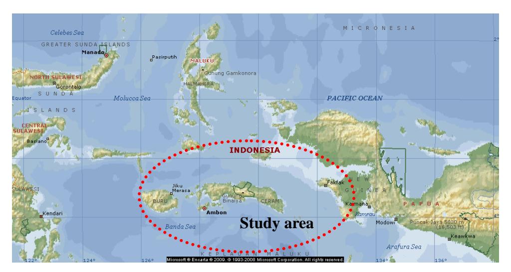
Figure 1 Study area of customary marine tenure in Maluku Islands.
Through the ethnographical approach employed in the assessment of the problem of marine tenure in Maluku Islands, petuanan and sasi are considered as the fundamental concepts within the customary marine tenure system in this region. Petuanan is pointing on the exclusivity of land (petuanan land) and sea (petuanan laut or labuhan). The concept of sasi is related to customary marine tenure because it is an institution that regulates the exploitation of existing resources in the territorial sea (petuanan sea). Sasi concept also clarifies the structure of sea tenure model. This section focuses on the discussion regarding sea rights in the Maluku Islands.
Discussion related to customary marine tenure in Maluku could not be separated from the concept of ownership. In areas of Maluku in general and particularly in Nolloth (Saparua Island) and Haruku (Haruku Island), Central Maluku, Village Latuhalat (Ambon Island), Kei Islands (Southeast Maluku) and Dufa-dufa Village, Ternate Island (North Maluku), the concept of ownership is existed both in land and sea area.
Additionally, the villages in Maluku that are located within the coastline also consist of marine territory, which act as the extension of petuanan to the ocean. The petuanan sea boundaries were drawn from the village boundaries on the mainland. Marine area is called the petuanan sea, or in Nolloth and Haruku called labuhan.
In Central Maluku (Nolloth and Haruku, Ambon Island, Latuhalat) and Southeast Maluku (Kei), the boundary of petuanan sea, as well as petuanan land, are relatively clear. When the boundary between petuanan land of one village and other villages is adjacent to natural boundary objects such as river, hills, peninsula caves; or artificial boundary objects such as deliberately planted trees, stakes; the boundary of labuhan or petuanan sea is normally represented by a straight imaginary line drawn from the boundary of petuanan land to the sea.
Therefore, the boundary among petuanan sea is an imaginary character, which off course tends to increase its subjectivity due to the different perception exercised by each village. So the petuanan sea boundaries are flexible, which are normally determined by their vicinity.
The boundary of petuanan sea area is the limit between petuanan sea. While the boundary between petuanan sea village (the village's sea) and sea-owned (public property) or sea common property that the people of Maluku is called the free seas is an imaginary line located between the shallow sea (in Nolloth, Haruku, and Kei is called white sea or tohor; in Latuhalat is called as saaro) and deep sea (in Nolloth, Haruku, and Latuhalat is called blue sea).
The word 'saaro' in Latuhalat and tohor in Nolloth and Haruku, often described as the border between petuanan sea and the free sea. While at Kei, the boundary of petuanan sea is called meti or metin. The word 'meti' or metin actually has two meanings, the first one means at the time when sea levels receded (tidal), the second one means a shallow place in the middle of the sea. So petuanan sea areas in the Kei region could refer to meti and the shallow places in the deep sea as long as the places still inside the boundary of sea-owned Ratschaaf (A Ratschaaf consists of several villages).
As in Kei, in Latuhalat also claims the shallow places inside deep sea area. Even as rural areas Latuhalat also includes a group of islands that is located slightly apart of approximately 130 miles southern of the village center. The group of islands is called the Seven Islands because it consists of seven islands and is also called Turtle Island because there are many turtles (Chelonia nydos). If at Kei and Latuhalat, shallow places in the middle of the deep sea (meti) is claimed as a certain petuanan Ratschaaf, then in Dufa-dufa (Ternate), places in which at low tidal looks like pond, by the people of Ternate (Village Dufa-Dufa) is called 'hole' and is also claimed as belonging to the village. While the sea boundaries of the Village Dufa-dufa is called 'ngolasabe', which means the territorial sea from the coast to a depth of 10 meters or sea borders between the white and black color (Figure 2)
Figure 2 Delineation of petuanan sea in North Maluku.
The existence of the petuanan sea or labuhan means that the area within these boundaries to be exclusive in the sense that the management of environmental resources and rural communities are entitled to claim it. Thus, other people are prohibited from managing or exploiting marine resources within it.
Unlike the petuanan land whose ownership could be in the hands of individual or group of people, the petuanan sea is fully belong to the village. The fact that no one from the villages have the right to transfer the ownership of the territory to others, the only one who has the authority is a village head, who acts on behalf of the village. In the concept of ownership, there is a set of rights which is not only for exploiting but also for moving the right.
The concept of ownership can be clearly seen especially in Nolloth and Haruku. In these two villages known a petuanan sea, called as labuhan sasi, That is a very exclusive area and closed for anyone, including community members from the village. Community members are prohibited to enter labuhan sasi area although they do not intend to exploit marine resources. In Nolloth, this rule gives exception to foreign tourists who want to see, swim, or dive in the sea, but with the permission of the head of the village and when entered it should be accompanied by village officials. The exploitation of resources in labuhan sasi is regulated by the village government, such as bia-lola (Trocus Niloticus) and some other resources. Bia-lola is protected by the village government in order to have ample opportunity to breed, because the resouce is relatively scarce. In addition, also in order to obtain optimal results, because of its high economic value. Location of bia-lola or labuhan sasi area is about 6 km from the village Nolloth in the eastern of Saparua Island. Figure 3 shows the petuanan area of Nolloth Village.
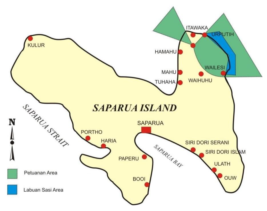
Figure 3 The map of petuanan area of Nolloth Village.
According to the notes made by the Village Head Nolloth, the length of the sasi has grown twice until recently. In the year 1977, only along 1 km parallel to the coastline, then in 1978 increased to 2 km and from 1990 to 1993 the length became 2.5 km. The additional of that area is due to the proliferation of biolala, which is increasing the population number and scattered locations.
In petuanan sea/labuhan area in Haruku, there are also areas which at certain times the exploitation of their resources is closed or prohibited to anyone including the people of Haruku Village, except with certain tools and certain types of resources (labuhan sasi). Labuhan sasi in Haruku village is divided into two parts, labuhan sasi sea and labuhan sasi lompa fish. As a boundary of labuhan sasi sea, an imaginary line is drawn along 200 meters from the corner of the village hall towards the sea and southern part until Wairusi Cape, near Fort Newzeland (Figure 4). This labuhan sasi sea is estimated as 600 meters. From Wairusi Cape to the southern part of Hi-I Cape with length of about 1500 meters and width of 200 meters towards the sea is the labuhan sasi lompa fish.
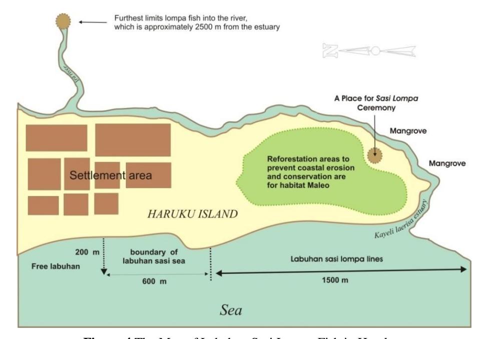
Figure 4 The Map of Labuhan Sasi Lompa Fish in Haruku.
Exclusivity of labuhan sasi sea is due to the mobility of protected resources by the villagers of Haruku, known by the name of lompa fish (Trisna baelama) and make fish, a type of small sardines. These areas are closed for either lompa and make fish exploitation for the reason when the area is opened to exploitation, the result will be enough to share to all Haruku community. With the closing of labuhan sasi sea, people are prohibited to exploit the resources inside labuhan sasi, except with fishing gear and nets without using boat.
3 Conclusion and Future Works
The existence of customary marine tenure in Maluku could be found within the concept of petuanan and sasi. The concept of petuanan and sasi characterize the tenure model related to customary marine tenure which could be well identified. The above mentioned concept acts as well as the institution that regulates the systems of exploitation of existing resources in the sea teritorial. In the future, there is a need for studying the use of customary marine tenure as collateral for marine space that is used as a tool to empower coastal communities.
4 References
- Abdulharis, R., Djunarsjah, E., and Hernandi, A., Stakeholder Analysis on Implementation of Marine Cadastre in Indonesia, Proceedings FIG Working Week 2008, 2008.
- Barry, M., Evaluating Cadastral Systems in Periods of Uncertainty, PhD dissertation, University of Natal, Durban, 1999.
- Bryman, A., Social Research Methods, Oxford University Press, 2008.
- Carr, A Second Fall. The Economist, 1998.
- Dale, P. & McLaughlin, J., Land Administration, Oxford University Press, 1999.
- Enemark, S., Understanding the Land Management Paradigm, in Proceeding of FIG Commission 7 Symposium on Innovative Technologies for Land Administration, 2005.
- Hanna, M. G. & B. Robinson, Strategic for Community Empowerment : Direct-Action and Transformative Approaches to Social Change Practice, The Edwin Mellen Press, 1994.
- Hoogsteden, C., The Political Economy Behind New Zealand's Emerging Maritime Cadastre : Principles, Experiences and Future Challenges, Proceedings of the 12 th Conference of South African Surveyor, 2001.
- Hikmat, H., Strategi Pemberdayaan Masyarakat, Humaniora, 2006.
- Nichols, S. M., Sutherland, S. Ng'ang'a & D. Monahan, Report on the proceedings of the Association of Canadian Land Surveyors Stakeholders Workhsop on Canada Lands Offshore, Association of Canada Land Surveyors.
- Robertson, B., Benwell G. Hoogsteden, The Marine Resource: Administration Infrastructure Requirements, UN-FIG Conference on Land Tenure and Cadastral Infrastructure for Suistanable Development, 1999.
- Sutherland, MD., 2001. Marine Boundaries in Support of Good Ocean Governance. PhD dissertation, Department of Geodesy and Geomatics Engineering, University of New Brunswick, Fredericton, 2001.
- Tamtomo, J.P., Analisis Kebijakan Pemanfaatan Ruang Pesisir dan Laut dalam Kerangka "Marine Cadastre" (Studi Kasus di Wilayah Pulau Bintan, Kabupaten Kepulauan Riau). Disertasi, Sekolah Pascasarjana IPB, Bogor, 2006.
- Wahyono, A., Patji, A.R., Laksono, D.S., Indrawasih, R., Sudiyono & Sumiati, A., Hak Ulayat Laut di Kawasan Timur Indonesia, Media Pressindo, 2000.