
Introduction
Sulawesi is a rapidly deforming region in Indonesia at the convergence between the Pacific, Australian, and Eurasian plates (Bock et al., 2003; Hall, 2012; Hall & Wilson, 2000; Hamilton, 1979). This convergence is primarily accommodated by densely distributed active faults and subduction zones, resulting in intense seismicity in Sulawesi. Many large (Mw ≥7) and damaging earthquakes have occurred in the region over the last century, including the 1969 Mw 7.0 Majene, the 1996 Mw 7.9 Toli-toli, and the 2018 Mw 7.5 Palu earthquakes (Figure 1; (e.g., Gómez et al., 2000; Natawidjaja et al., 2021; Pranantyo et al., 2023). These events highlight the high seismic hazard in Sulawesi and underscore the need to better understand the seismic behavior of active faults.
However, most active fault studies in Sulawesi have focused on the major structures, such as the Palu-Koro, Matano, Gorontalo, and Makassar thrust faults (e.g., Efendi et al., 2021; Gunawan et al., 2022; Meilano et al., 2023; Natawidjaja et al., 2021; Patria et al., 2023; Puspita et al., 2005). Serhalawan & Chen (2024) analyzed the <60 km-deep seismicity in Sulawesi and divided the region into several regions based on the seismicity patterns. In several parts of Sulawesi, active faults have been identified and included in the 2024 National Seismic Hazard Map by the Center of National Earthquake Study (PuSGeN) (2024), but they lack basic information, such as precise fault locations and kinematics.
This study integrates geological, geodetic, and geophysical data to examine the geological influence on faulting style and mechanism. Furthermore, it provides kinematic analyses of key active faults, based on geomorphic interpretations, re-evaluations of GPS velocities by Socquet et al. (2006), and analyses of earthquake focal mechanism solutions from the Global Centroid-Moment-Tensor (GCMT) catalog (Ekström et al., 2012). Then, we discuss the implications for active tectonics and seismic hazard in Sulawesi.
Copyright by authors ©2026 Published by IRCS - ITB J. Eng. Technol. Sci. Vol. 58, No. 1, 2025, 121-138
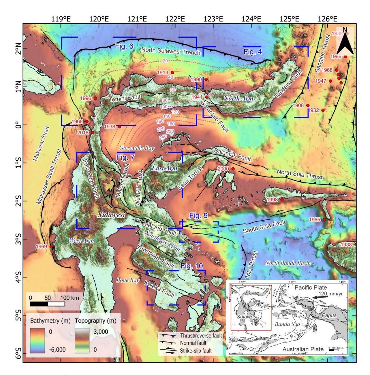
Principal active faults in Sulawesi and large (Mw ≥7) earthquake hypocenters during 1913‒2024 with ≤50 km deep (red circles), based on the compilation by the Center of National Earthquake Study (PuSGeN) (2024). Pink dashed lines indicate the depth of the subduction slab from Hayes et al. (2018). The base map is the National Digital Elevation and Bathymetric Model of Indonesia, provided by the Indonesian Geospatial Information Agency (https://tanahair.indonesia.go.id/).
Tectonic Setting
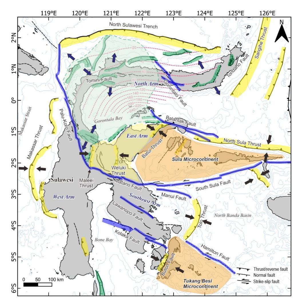
In Sulawesi, the convergence between the Pacific, Australian, and Eurasian plates is majorly accommodated by fastslipping strike-slip faults and subduction zones (Figure 2). The westward motion of the Pacific plate relative to the Australian plate is the major driving tectonic force that causes movement along strike-slip faults in eastern Indonesia, including Sulawesi. Additionally, the collision between Sula and Tukang Besi Microcontinents and Sulawesi added the complexity of faulting in Sulawesi (Hall, 2012; Hall & Wilson, 2000; Hinschberger et al., 2005; Kadarusman et al., 2004; Socquet et al., 2006; Villeneuve et al., 2002). These collisions have caused the activation of major faults that partition Sulawesi into several distinct lithotectonic blocks. The Sula collision, which primarily affected central and eastern Sulawesi, resulted in significant thrust faulting, block rotation, and reactivation of older fault systems. Meanwhile, the collision of the Tukang Besi microcontinent in the southeast has contributed to localized uplift and may influence the rotation of crustal blocks in the Southeast Arm.
The North Sulawesi subduction zone accommodates the north-south convergence between the Celebes Sea plate and the North Sulawesi arc, where the Celebes Sea Plate subducts southward beneath the North Arm of Sulawesi (Hall, 2012; Hamilton, 1979; Hayes et al., 2018; Silver et al., 1983). The subduction zone is characterized by a 560-km-long trench, located approximately 100 km from the northern coastline. The trench reaches 5 km in depth and extends from north of Manado to the northern end of the Palu-Koro fault (Hall, 2018; Silver et al., 1983). The convergence rate along the subduction increases toward the west from 20 to 54 mm/yr, causing a clockwise rotation about a pole located at the northeast of Manado (Socquet et al., 2006; Stevens et al., 1999; Walpersdorf, Vigny, Manurung, et al., 1998; Walpersdorf, Vigny, Subarya, et al., 1998). Hall (2018) suggested that the North Sulawesi subduction trench has progressively migrated northward since approximately 4-5 Ma due to slab rollback. Seismicity due to this subduction zone reaches a depth of 250 km (Greenfield et al., 2021). The largest earthquake ever recorded due to the North Sulawesi subduction megathrust was the 1996 Mw 7.9 earthquake near Toli-toli at a depth of 16 km (Gómez et al., 2000). Other significant earthquakes (Mw ≥7) in 1990, 1991, 1997, and 2008 were also caused by this subduction megathrust (Ekström et al., 2012).
Central Sulawesi is dominated by a fast-slipping left-lateral strike-slip fault system consisting of the Palu-Koro and Matano faults, collectively known as the Central Sulawesi Fault System (CSFS) (Bellier et al., 2001). The CSFS is regarded as a plate boundary fault system that accommodates the westward movement of the Sula microcontinent and the clockwise rotation of the northern half of Sulawesi (Hamilton, 1979; Silver et al., 1983; Socquet et al., 2006; Watkinson & Hall, 2017). The Palu-Koro fault is oriented nearly north-south and extends for 460 km, from the western end of the North Sulawesi subduction trench to central Sulawesi. The Matano fault is a continuation of the Palu-Koro fault to the south. It is ~290 km long, with a relative northwest-southeast orientation, differing from the north-south orientation of the Palu-Koro fault. Recent observation by Patria et al. (2023) showed that the Matano fault continues further offshore and connects to the South Sula fault to the east. The slip rate appears to decrease to the east, where the Palu Koro fault slips at a rate of 40 mm/yr rate (Bellier et al., 2001; Socquet et al., 2006; Walpersdorf, Vigny, Manurung, et al., 1998), while the Matano fault moves more slowly at a rate of 20 mm/yr (Khairi et al., 2020; Patria et al., 2023; Walpersdorf, Vigny, Manurung, et al., 1998). Patria et al. (2023) suggested that the rollback of the North Sulawesi trench might cause the slip difference between the Matano and Palu-Koro faults. In terms of seismic hazard, these faults have the capability to generate large earthquakes (Mw ≥7), as shown by the 2018 Mw 7.5 Palu earthquake (Natawidjaja et al., 2021) and the 1998 Mw 7.7 South Sula earthquake (Vigny et al., 2002).
Methodology
We integrated geological, geodetic, and geophysical datasets to analyze faulting styles and tectonic deformation across Sulawesi. Earthquake data were compiled from the catalog published by the Center of National Earthquake Study (PuSGeN) (2024), covering events from 1900 to 2024 from various catalogs: (1) ISC-EHB and ISC-GEM bulletins from the International Seismological Centre (ISC), (2) relocation of the Indonesian Agency for Meteorology, Climatology, and Geophysics (BMKG) seismicity data, and (3) the United States Geological Survey (USGS) earthquake catalog. The earthquake magnitudes in the Center of National Earthquake Study (PuSGeN) (2024) compilation were standardized to moment magnitude (Mw), following the methodology described in Scordilis (2006). We selected earthquakes with a magnitude (Mw) of ≥4 and a depth of ≤50 km to evaluate the active crustal deformations, considering the maximum crustal thickness in Sulawesi of 48 km (Heryandoko et al., 2024). Focal mechanism solutions of earthquakes with a magnitude (Mw) ≥5 and a depth ≤50 km since 1976 were obtained from the Global Centroid Moment Tensor (GCMT) catalog (Ekström et al., 2012). The mechanisms were classified as thrust, strike-slip, or normal faulting based on tension and null axis plunges; thrust faults are those with plunge >45° of the tension axis, strike-slip faults have plunge >45° of the null axis, and normal faults have plunges of <45° for both tension and null axes. Additionally, the results of crustal thickness mapping by Heryandoko et al. (2024) were combined with the geological map by Hall & Wilson (2000) and the active faults compiled in the Center of National Earthquake Study (PuSGeN) (2024) to assess the geological influence on the fault distribution and deformation style in Sulawesi.
For selected regions where the fault kinematics are enigmatic, tectonic geomorphic analyses were conducted using the 8-m-resolution National Digital Elevation Model of Indonesia (DEMNAS), provided by the Indonesian Geospatial Information Agency (BIG). Hillshade and slope maps were generated to identify geomorphic features associated with active faults, such as fault scarps, linear valleys, and other tectonic landforms. Geomorphic interpretations were crossreferenced with known fault traces from previous studies and the national seismic hazard map (Center of National Earthquake Study (PuSGeN), 2024). The results were then combined with the seismicity and earthquake focal mechanism solutions. GPS velocity data from Socquet et al. (2006) were also integrated into the analysis. Re-evaluations of the GPS velocity vectors were performed by modifying reference points to selected sites, allowing clearer illustrations of the differential motions across the active faults. The re-interpretations aimed to refine the relationship between surface strain and mapped fault structures, particularly in regions lacking slip rate estimations.
Result
Seismicity
Based on the earthquake catalog compilation by Center of National Earthquake Study (PuSGeN) (2024), Sulawesi generally has a high level of shallow crustal seismicity (≤50 km deep) (Figure 2A). Seismicity is majorly distributed in the North Arm, Southeast Arm, West Arm, and in Central Sulawesi, each with distinct fault mechanisms. In some areas, such as Gorontalo Bay, Bone Bay, and South Sulawesi, seismic activity is relatively less intense.
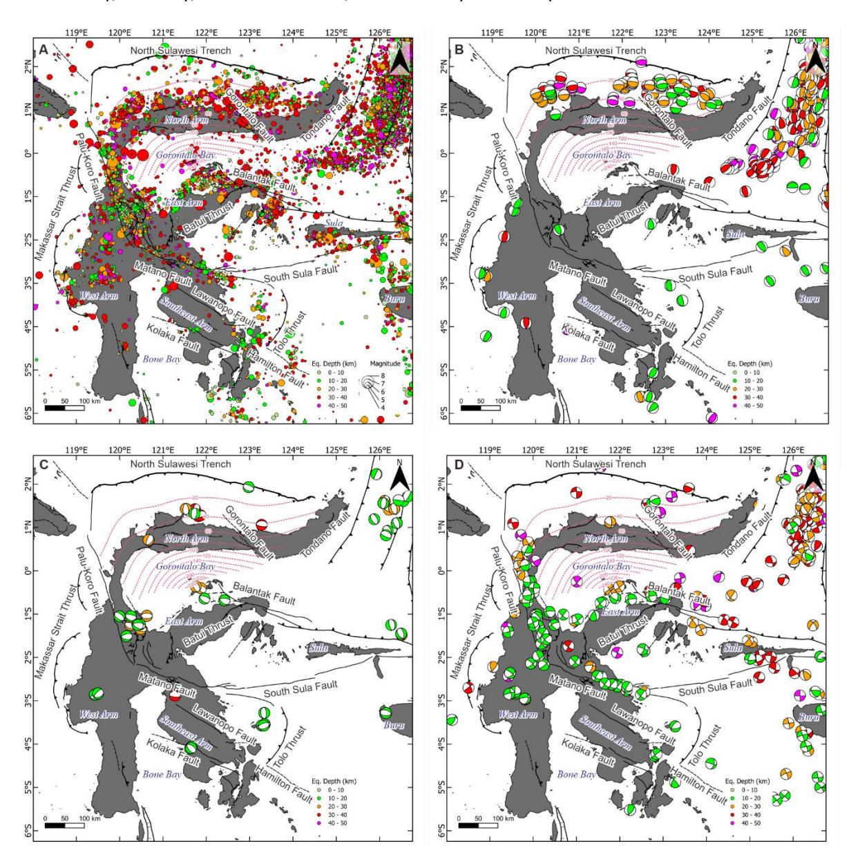
(A) Seismicity of Sulawesi Region with a depth of ≤ 50 km based on the catalog compilation by the Center of National Earthquake Study (PuSGeN) (2024) covering a period of 1900–2024. (B, C, and D) Focal mechanism solutions of thrust, normal, and strike-slip fault earthquakes, respectively, with a depth of ≤ 50 km during 1975‒2024 from the GCMT catalog (Ekström et al., 2012).
The shallow earthquakes in North Arm were mainly caused by the North Sulawesi subduction zone with a thrusting mechanism (Figure 2B). However, several normal-fault earthquakes occurred around the North Arm (Figure 2C). Most of these earthquakes are located above the subduction slab, suggesting extensional deformation of the overriding plate or the North Sulawesi Arc (Advokaat et al., 2017; Tiranda, 2022). In the East Arm, seismicity is concentrated along and adjacent to the Balantak fault with a predominant strike-slip fault solution (Figure 2D). Normal fault earthquakes are observed west of the Balantak fault and east of the Palu-Koro fault (Figure 2C), likely related to the crustal extension in the Gorontalo Bay (Pezzati et al., 2014; Pholbud et al., 2012).
Central Sulawesi obviously has prominent seismicity along the CSFS (Figure 2A). East of the Matano fault, the seismicity disappears on the western portion of the South Sula fault until south of Sula, where the earthquakes are clustered along the eastern portion of the South Sula fault. The lack of earthquakes on the western South Sula fault may indicate that the fault is accumulating energy or behaving aseismically. The focal mechanism solutions also indicate a left-lateral motion for a nodal plane parallel to the faults (Figure 2D). Additionally, several thrust fault earthquakes around the eastern end of the South Sula fault, between Buru and Sula, indicate contractional deformation in this area (Figure 2B)
In West Sulawesi, between the Makassar Strait thrust and Palu-Koro fault, seismicity is closely related to the east-dipping Makassar Strait thrust as indicated by the thrust fault earthquake solutions (Figure 2A & B). Strike-slip fault earthquakes are also dominant in the West Arm (Figure 2D), showing the interplay between the thrust and strike-slip faulting. In the Southeast Arm region, seismicity is less intense than in the other arms. Thrust fault earthquakes west of the Tolo thrust show nodal planes that are oriented similarly to the thrust orientation. Thrust fault earthquakes also occurred in the southern portion of the arms (particularly around Muna and Buton), indicating that the collision between the Tukang Besi Microcontinent and the Southeast Arm remains active (Satyana & Purwaningsih, 2011).
Crust lateral heterogeneity
Sulawesi consists of four arms with distinct lithotectonic units (Figure 3). The North and West Arms comprise volcanic and plutonic rocks as well as associated sediments. The East and Southeast Arms are composed of the Central Sulawesi Metamorphic Belt, the East Sulawesi Ophiolite, and the accreted Sula and Tukang Besi Microcontinents (Hall & Wilson, 2000; Kadarusman et al., 2004). The geology of Sulawesi controls its structural pattern. The South Sula fault is a geological boundary between the Sula Microcontinent and the North Banda oceanic basin (Hall, 2018; Hinschberger et al., 2005; Titu-Eki & Hall, 2020). The Matano fault traverses the ophiolite and metamorphic complex units (Kadarusman et al., 2004; Tjia, 1978). The Palu-Koro fault cuts across the volcanic and plutonic province (Hennig et al., 2017; van Leeuwen et al., 2016). Some faults also form boundaries between the geological units, such as the Batui, Weluki, and Maleei thrusts, as well as the Lawanopo and Kolaka faults (e.g., Hall & Wilson, 2000; Kadarusman et al., 2004). North of the Matano fault, the Maleei and Weluki thrusts separate the Central Sulawesi Metamorphic belt from the volcanic and plutonic province and the East Sulawesi Ophiolite. Similarly, the Lawanopo and Kolaka faults define the boundary between the metamorphic and ophiolite belts.
The transitions between the large strike-slip faults correspond to lateral changes in geologic provinces (Figure 3). The transition from the South Sula fault to the Matano fault coincides with the lithotectonic transition from the boundary between the Sula Microcontinent and the North Banda basin to the east Sulawesi ophiolite belt. This transition is also marked by a change in the fault orientation from WSW-ENE along the South Sula fault to NW-SE along the Matano fault. Furthermore, the change in strike from the NW-SE-trending Matano fault to the NNW-SSE-oriented Palu-Koro fault marks a geologic transition from the metamorphic unit to the volcanic and plutonic rocks.
The variation in lithotectonic units appears to closely correlate with the Moho depth/crustal thickness (Heryandoko et al., 2024) Figure 3). The West and North Arms, composed of volcanic and plutonic rocks, are characterized by a predominantly >40 km thick crust. This thicker crust is likely a result of magmatic underplating and crustal growth due to prolonged arc magmatism, which is commonly observed in active or former magmatic arc settings (Ganade et al., 2021; Haschke & Günther, 2003). However, there are several locations, such as Toli-Toli, Tomini, west of Palu Bay, and the southern West Arm, where the crust is ≤40 km thick. These anomalies may reflect tectonic reworking or crustal extension related to faulting and basin development along major fault systems such as the Palu-Koro Fault, which can locally reduce crustal thickness. The metamorphic and ophiolite belts in central Sulawesi and the East and Southeast Arms have thinner crust, generally ≤40 km. Such thinner crusts are typical of deformation by exhumation and extensional processes (Advokaat et al., 2017; Guntoro, 1999; Hennig et al., 2017). The accreted microcontinents of Sula and Tukang Besi also exhibit similar crustal thickness to the metamorphic and ophiolite belts, indicating that these microcontinents have undergone tectonic thinning.
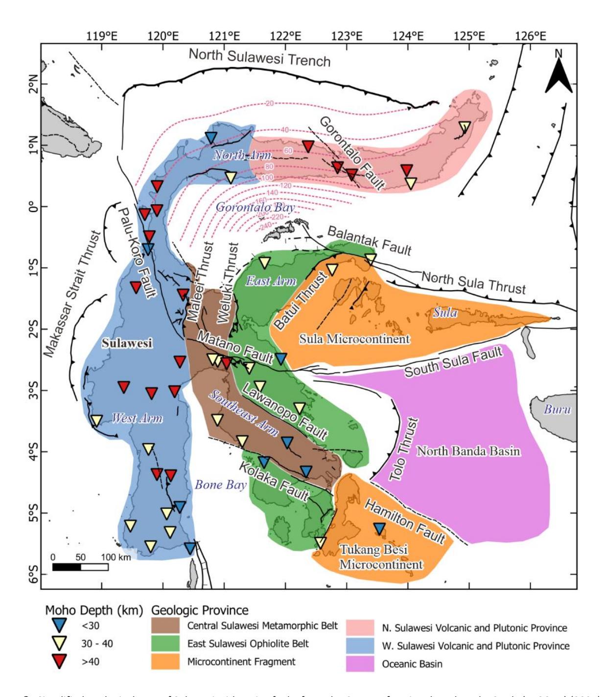
Simplified geological map of Sulawesi with active faults from the Center of National Earthquake Study (PuSGeN) (2024) and the crustal thickness from Heryandoko et al. (2024).
Extension in the North Arm
The North Arm is closely associated with the North Sulawesi subduction zone (Figure 1). However, the overriding plate is currently extended due to the subduction rollback (Advokaat et al., 2017; Hall, 2018; Tiranda, 2022). Normal fault earthquakes also suggest extensional deformation in the North Arm (Figure 2C & 4). In the eastern North Arm, NE-SW trending intramountain depressions, such as Tondano and Bolaang Mongondow, are interpreted as results of crustal extension (Figure 4). An earthquake solution indicates a normal faulting mechanism with east-west trending nodal planes (marked by a dotted circle in Figure 4). North of Gorontalo, submarine depressions exhibit orientations comparable to the onshore depressions, suggesting a similar origin and kinematic force.
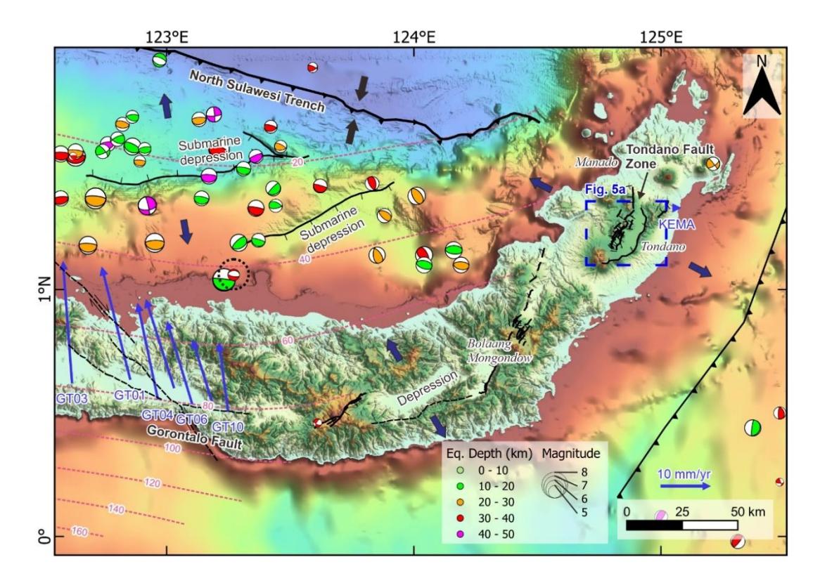
Updated active faults in the eastern North Arm. Focal mechanism solutions of shallow (<50 km deep) earthquakes are from the GCMT catalog (Ekström et al., 2012). GPS velocity vectors (blue arrows) from Socquet et al. (2006) are shown relative to site KEMA. A dotted circle marks the normal fault earthquakes with a depth of 34.7 km. Large black and navy-blue arrows indicate the estimated contraction and extension directions, respectively. Topography, bathymetry, and fault legends are provided in Figure 1.
Lake Tondano is situated within a structurally controlled basin in a volcanic complex (Figure 5A). The depression was previously interpreted as a pull-apart basin due to strike-slip faults in the north and south (Lécuyer et al., 1997). However, our geomorphic analysis using DEMNAS indicates no evidence of strike-slip faults bounding the lake. Based on our geomorphic interpretation, the Tondano fault zone can be divided into two distinct fault segments (Figure 5A). The eastern fault is marked by a 36-km-long escarpment between the Lembean Mountains and Lake Tondano. The western fault is characterized by numerous fault scarps facing east and west. These fault traces are typically short, ranging from 2 to 8 km in length, which collectively span 30 km. The Tondano fault zone resembles the Taupo fault zone in New Zealand, an extensional fault zone within a volcanic complex near the convergence boundary (Berryman & Beanland, 1991). The 1987 Mw 6.5 Edgecumbe earthquake on the Taupo fault zone was characterized by several short fault ruptures (0.5-7 km) with a combined length of 35 km and large displacements up to 2.5 m (Beanland et al., 1989).
Southwest of Lake Tondano, a 6-km-long fault segment is marked by a 10-m-high scarp cutting an alluvial fan surface, dated ~12,700 years before present (yBP) (Dam et al., 2001) (Figure 5B). This yields an estimated vertical slip rate of 0.7 mm/yr. North of this scarp, another fault scarp deforms an older volcanic surface and reaches a height of 19 m. The increase in scarp height from younger to older surfaces indicates repeated movement on the fault, with the older scarp recording greater cumulative displacement. The western North Arm has experienced a lithospheric extension since the Miocene, facilitated by the Tomini and Malino faults that exhumed the Malino Metamorphic Complex (MMC) (Figure6; Advokaat et al., 2017). Velocity analysis using GPS vectors from Socquet et al. (2006) shows a relatively north-south divergence of 2 mm/yr between sites TOLI and TOMI (Figure 6). Normal faults between Toli-Toli and Tomini likely accommodate this divergence. The crust in this area is 29‒36 km thick, thinner than that of adjacent regions that reach 48 km (Heryandoko et al., 2024), suggesting that the crust has extended.
East of Buol, a submarine depression appears to be the continuation of the Buol fault. Several normal fault earthquakes occurred around this depression at depths of 17‒30 km, shallower than the subducting slab (Figure 6). These earthquakes evidence the extension of the overriding plate. West of Toli-Toli, two normal faults were identified offshore. The East Toli-Toli fault is characterized by a west-facing scarp that cuts a submarine ridge near the trench. The West Toli-Toli fault, firstly reported by Tiranda (2022), is indicated by landward-facing scarps that bound a submarine depression. In 1968, an earthquake of Mw 7.4 occurred near the Palu-Koro fault (Figure 6). However, Prasetya et al.
(2001) pointed out that the earthquake had a normal fault mechanism, not a strike-slip fault, although no focal mechanism beachball was provided. The normal fault mechanism suggests that the earthquake might not be caused by the Palu-Koro fault, but rather by a large normal fault such as the West Toli-Toli fault.
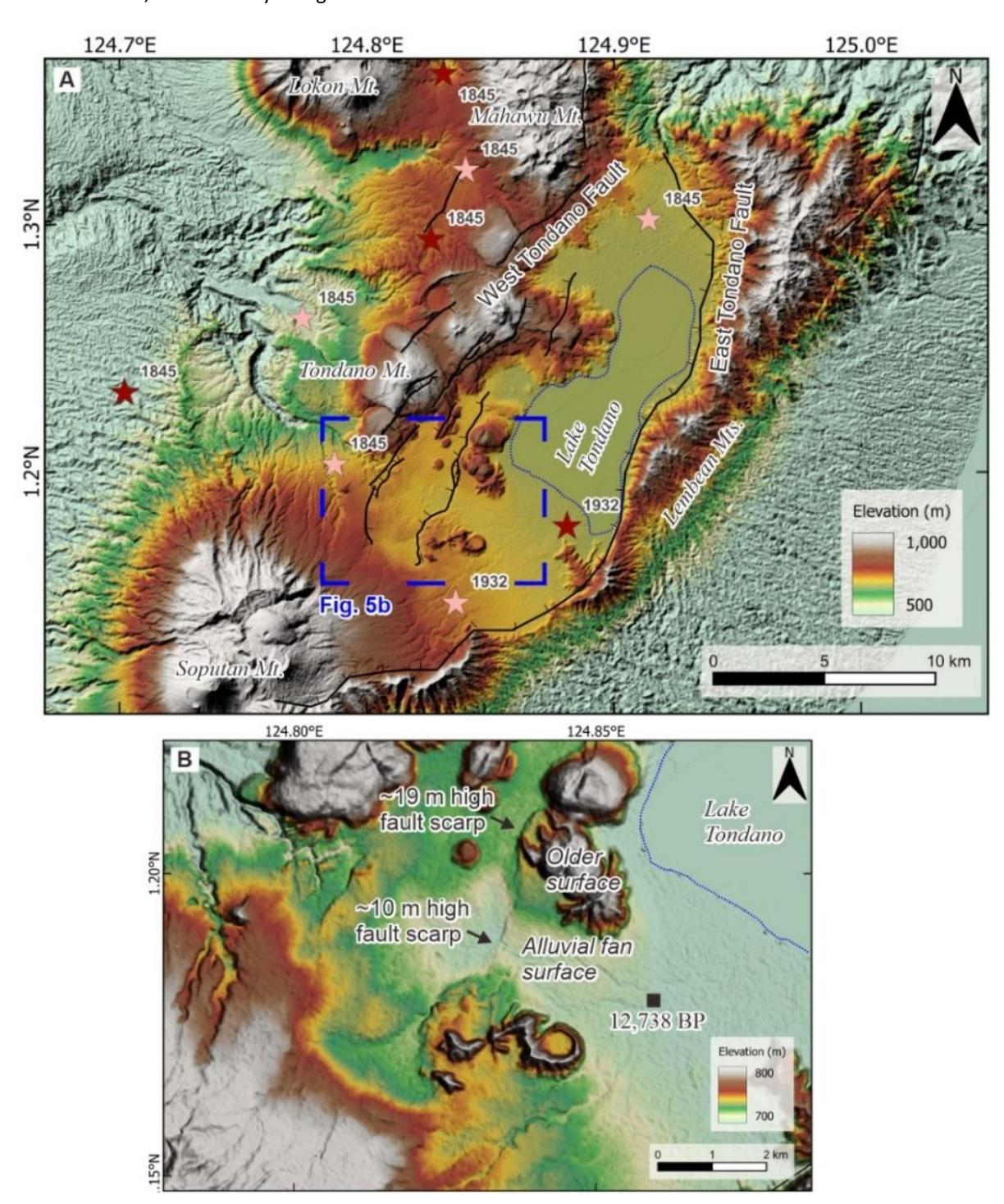
(A) Detailed interpretation of the Tondano fault zone. Red and pink stars indicate the extreme earthquake intensity of IX and X, respectively, using the European Macroseismicity Scale (EMS-1998) (Martin et al., 2022). (B) Prominent fault scarps cutting the late Quaternary surfaces. The age of the alluvial fan surface is from Dam et al. (2001).
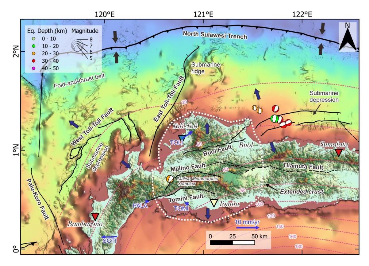
Updated active faults in the western North Arm. Focal mechanism solutions of shallow (<50 km deep) normal fault earthquakes are from the GCMT catalog (Ekström et al., 2012). GPS velocity vectors (blue arrows) from Socquet et al. (2006) are shown relative to site PALA. Dotted white lines delineate a possible area with a thinner crust than adjacent regions. Large black and navy-blue arrows indicate the estimated contraction and extension directions, respectively. Topography, bathymetry, and fault legends are provided in Figure 1. Inverted triangles indicate the crustal thickness from Heryandoko et al. (2024) (see Figure 3 for Moho depth legend).
Contraction and extension in central Sulawesi
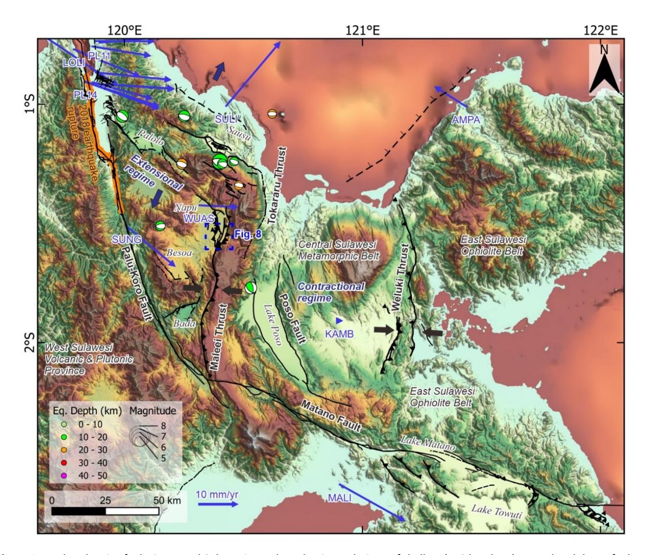
In central Sulawesi, the area between the Matano and Palu-Koro faults shows two distinct structural patterns (Figure 7). The area north of the Matano fault is characterized by north-trending faults, such as the Poso fault, Maleei, and Weluki thrusts, while the area east of the Palu Koro fault is dominated by NW-SE-oriented normal faults (e.g., Center of National Earthquake Study (PuSGeN), 2024; Nugraha et al., 2023; Wang et al., 2018). Analysis of GPS velocities from Socquet et al. (2006) indicates about 10 mm/yr contraction between sites WUAS and KAMB in the east-west direction, which is considerably accommodated by the Maleei thrust (Figure 7). The thrust shows an apparent late Quaternary activity as fault scarps cutting fluvial terraces in the Napu valley (Figure 8). South of Napu, the fault delineates the western edge of the metamorphic belts in mountainous terrain. A thrust fault earthquake near Lake Poso with a northsouth nodal plane further suggests the recent activity of the Maleei thrust. The GPS velocities also show about 9 mm/yr differential motion between sites AMPA and KAMB, which is likely accommodated by the Weluki thrust (Figure 7).
Updated active faults in central Sulawesi. Focal mechanism solutions of shallow (<50 km deep) normal and thrust fault earthquakes are from the GCMT catalog (Ekström et al., 2012). GPS velocity vectors (blue arrows) from Socquet et al. (2006) are shown relative to site KAMB. Large black and navy-blue arrows indicate the estimated contraction and extension directions, respectively. Topography, bathymetry, and fault legends are provided in Figure 1.
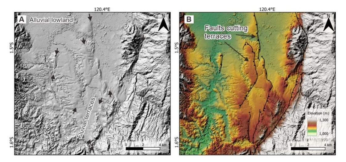
Fault scarps cutting the fluvial terraces in the Napu Valley are shown in the hillshade map (A) and the active fault interpretation map (B). Small arrows in (A) indicate the fault scarps.
The extensional regime east of the Palu-Koro fault is associated with several intramountain basins, including the Palolo, Napu, Bada, and Besoa Valleys. These basins are interpreted due to crustal stretching induced either by the subduction rollback (Hall, 2018; Pholbud et al., 2012) or by the gravitational collapse and lateral mass extrusion (Wang et al., 2018). The extension is bounded by the Maleei and Tokararu faults to the east and the Palu-Koro fault to the west (Figure 7).
Normal fault earthquake solutions are also limited within this zone, indicating a northeast-southwest extension. This extension is also supported by the GPS velocity evaluation, where sites SULI and SUNG move in opposite directions, with a total extensional motion of ~27 mm/yr. This extension is accommodated by several normal faults from Bada in the south to Sausu in the north.
Central Sulawesi fault system
The term "Central Sulawesi fault system (CSFS)" was first introduced by Bellier et al. (2001) to describe the left-lateral strike-slip Palu-Koro and Matano faults in central Sulawesi. A recent observation by Patria et al. (2023) using multibeam bathymetry data from Titu-Eki & Hall (2020) showed that the Matano fault extends to the east and connects to the South Sula fault, suggesting that the fault system also includes the South Sula fault. The Matano and South Sula faults are separated by a 13-km-wide pop-up structure (Figure 9). Along the strike of CSFS, the orientations of the composing faults are distinctive. The South Sula fault is oriented ENE-WSW, while the Matano fault trends in a NW direction (Figure 1). The Matano fault terminates at the south of the Maleei Thrust and links with the Palu-Koro fault, which has a significantly different orientation in the NNE-SSE direction (Figure 7). The change in fault orientation coincides with the change in crustal compositions cut by the faults (Figure 3). This fault orientation change resembles the fracture deflection during propagation through different lithologies due to a contrast of the material properties (such as Young's modulus and Poisson's ratio) (Gudmundsson, 2011). In the context of the CSFS, these lithotectonic transitions, such as the transition from the metamorphic belt to the volcanic and plutonic province, can lead to differences in mechanical strength. As faults propagate into zones with differing rheological properties, their orientation may shift to accommodate the local stress field more efficiently, resulting in fault deflections or a change in fault strike.
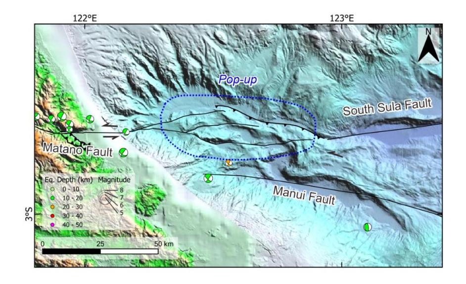
Pop-up structure at the boundary between the Matano and South Sula faults. Focal mechanism solutions of shallow (<50 km deep) earthquakes are from the GCMT catalog (Ekström et al., 2012). Multibeam bathymetry is from Titu-Eki & Hall (2020). Topography, bathymetry, and fault legends are provided in Figure 1.
Strike-slip Faulting in the Southeast Arm
The Lawanopo and Kolaka faults are major left-lateral strike-slip faults cutting the Southeast Arm, trending in NW-SE direction (Figure 1). Both faults were included in the seismic source model in the New National Seismic Hazard Map 2024 (Center of National Earthquake Study (PuSGeN), 2024). The Lawanopo fault was interpreted as the continuation of the Palu-Koro fault to the south and was estimated to slip at ~24 mm/yr (Socquet et al., 2006). However, a tectonic evaluation using geomorphic indices by Watkinson & Hall (2017) indicated that the fault's activity is moderate to low. Moreover, Natawidjaja & Daryono (2015) concluded that the Lawanopo fault is inactive due to a lack of geomorphic evidence of recent faulting activity.
In contrast, a left-lateral motion is plausibly accommodated by the Kolaka Fault Zone. The 210-km-long NW-trending fault zone consists of four fault traces with a length of up to 50 km, identified through tectonic geomorphic interpretation of DEMNAS data (Figure 10). The central segment, cutting a basin southeast of Kolaka, is characterized by 10–20 m high fault scarps on fluvial terraces, obviously indicating the fault's late Quaternary activity (Figure 11). The fault extends offshore in Bone Bay, expressed as seabed lineaments associated with a pop-up structure identified on seismic reflection profiles (Camplin & Hall, 2014).
GPS velocity vectors from Socquet et al. (2006) indicate that site KEND moves NNW at a rate of ~8.8 mm/yr, relative to site TOAR (Figure 10). The fault's parallel component is estimated at ~5.8 mm/yr, consistent with left-lateral motion between sites KEND and TOAR, while the normal-to-the-fault portion is calculated at ~6.5 mm/yr, representing the divergence rate between the two sites. Earthquake focal mechanism solutions on the fault near site KEND confirm the left-lateral motion along a NW-trending plane. However, several earthquake solutions in Kolaka at the North Segment indicate a normal faulting mechanism parallel to the fault. We therefore interpret that the Kolaka fault zone accommodates the motion between the two sites as a combination of left-lateral strike-slip and normal faulting.
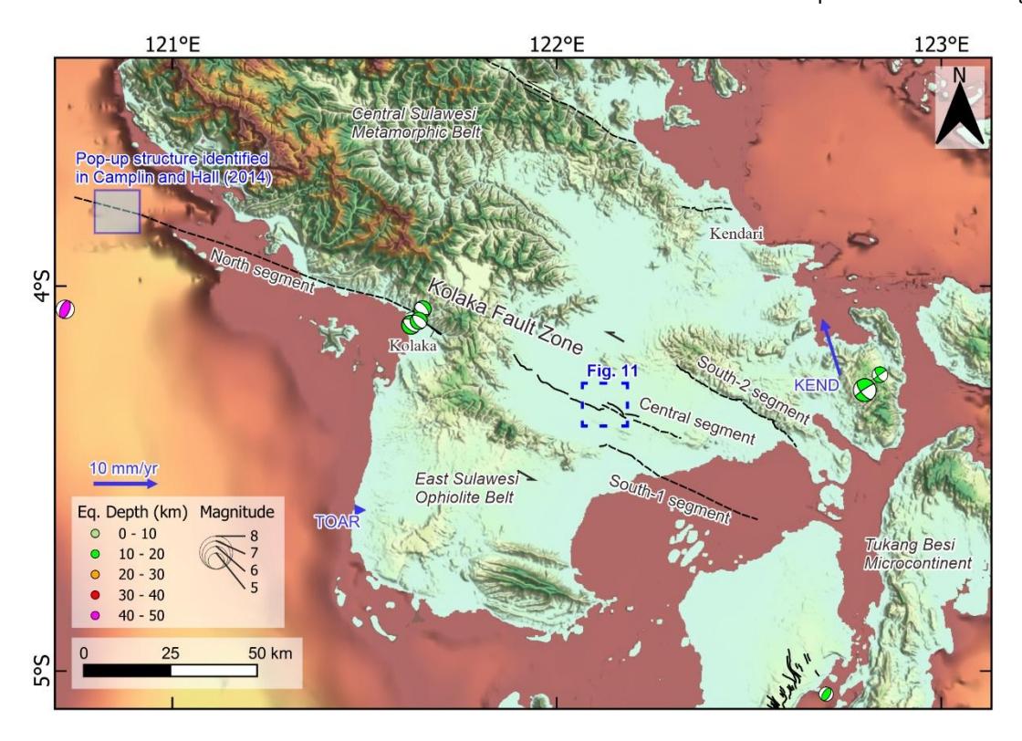
Updated active faults in the Southeast Arm. Focal mechanism solutions of shallow (<50 km deep) earthquakes are from the GCMT catalog (Ekström et al., 2012). GPS velocity vectors (blue arrows) from Socquet et al. (2006) are shown relative to site TOAR. Topography, bathymetry, and fault legends are provided in Figure 1.
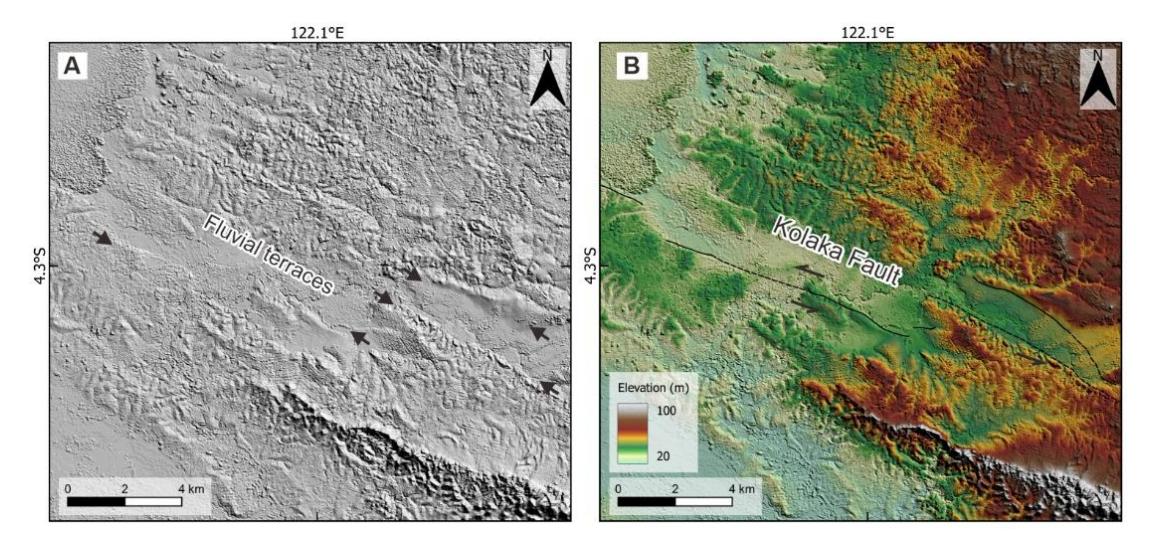
Fault scarps cutting the fluvial terraces in the South Konawe basin are shown in the hillshade map (A) and the active fault interpretation map (B). Small arrows in (A) indicate the fault scarps.
Discussion
The variation in crustal thickness across the different arms of Sulawesi corresponds to the differences in the seismogenic depth of active faults. A thicker crust implies a greater seismogenic depth and potentially a larger earthquake rupture zone (e.g., Jiao et al., 2021; Klinger, 2010). Along the CSFS, the crustal compositions involved in faulting vary significantly, resulting in differences in deformation style (Figure 3). The Palu-Koro fault traverses crust up to 48 km thick, consisting of the volcanic and plutonic provinces. The Matano fault cuts through the metamorphic and ophiolite belts with crustal thicknesses of ~24‒44 km. The South Sula fault deforms a thinner crust because it involves the oceanic crust (c.a. 7 km thick) of the North Banda basin. Given that the volcanic and plutonic provinces have a thicker crust than other lithotectonic units, the North and West Arms are more prone to larger earthquakes. For comparison, an earthquake with a given rupture length on the Palu-Koro fault would likely have a larger magnitude than one on the Matano fault. Seismogenic depth is used as one parameter in calculating the potential magnitude of earthquakes (e.g., Hanks & Kanamori, 1979; Stirling et al., 2013; Wells & Coppersmith, 1994). Therefore, the crustal thickness information, such as that provided in Heryandoko et al. (2024), is crucial for precisely evaluating the seismic hazard posed by active faults in Sulawesi.
Sulawesi is characterized by different deformation regimes in its distinct arms (Figure 12). The major strike-slip fault system, extending from the Palu-Koro fault to the South Sula fault, appears to play a significant role in controlling deformation in Sulawesi. Although the Palu-Koro fault connects to the western tip of the North Sulawesi subduction trench, the fault also limits the extensional regime in the western North Arm, Gorontalo Bay, and the area just east of the Palu-Koro fault. In contrast, the Matano fault bounds the contractional regime in the East Arm, which includes the Maleei and Weluki thrusts. This contraction accommodates the collision between the Sula Microcontinent and the East Arm, facilitated by the South Sula fault (Villeneuve et al., 2002).
Geomorphic depressions and shallow normal faulting earthquakes in the North Arm characterize the crustal extension in this arm (Figure 12). Pezzati et al. (2014) and Pholbud et al. (2012) showed that the Gorontalo and Poso basins south of the North Arm are dominated by extensional faults and have rapidly subsided since 5 Ma. This extension was interpreted as the result of subduction rollback of the Sulawesi Sea plate, driven by the slab pull forces (Advokaat et al., 2017; Hall, 2012, 2018). The rollback also caused the extension in the area east of the Palu-Koro fault, forming normal faults associated with the intramountain basins, i.e., Palolo, Bada, Napu, and Besoa. In addition to the subduction rollback, Wang et al. (2018) proposed that the gravitational collapse and lateral extrusion mechanism along the Palu-Koro fault may also contribute to the extension east of the fault. However, this interpretation cannot fully explain the slip difference between the Palu-Koro and Matano faults and the extension in the North Arm. The region north of the Matano fault is occupied by the thrust faults resulting from collisional tectonics of the Sula Microcontinent (Figure 12). The Batui and Maleei thrusts form fault contacts between lithotectonic units in central Sulawesi. The Matano fault slips left-laterally at ~20 mm/yr, and this motion is primarily absorbed by thrust faults, such as Maleei, Weluki, and Batui, because the GPS data indicate a ~19 mm/yr contraction rate north of the Matano fault. This suggests that although the Palu-Koro and Matano faults appear connected, only a small portion of the slip from the Matano is transferred to the Palu-Koro fault. Therefore, we interpret that the Palu-Koro fault's motion is significantly driven by the northward subduction rollback of the Sulawesi Sea plate, not the collision at the East Arm.
Schematic diagram showing the faulting domains in Sulawesi. Strike-slip, normal, and thrust fault domains are highlighted in blue, green, and yellow, respectively. Large black and blue navy arrows indicate the estimated contraction and extension directions, respectively.
The collision between the Tukang Besi Microcontinent and the Southeast Arm also influences the faulting in the region. Muna and Buton are located at the transition between the Tukang Besi Microcontinent and the ophiolite belt, which are separated by either a west-dipping collisional thrust front (Satyana & Purwaningsih, 2011) or a strike-slip fault (Center of National Earthquake Study (PuSGeN), 2024). Thrust fault earthquakes in Buton and Muna indicate that the collisional front remains active. This collision occurs at a slower rate compared to the collision of Sula, as evidenced by the lower level seismicity and deformation rate in the Southeast Arm. The Kolaka fault appears to be the main strikeslip fault that facilitates the collisions, rather than the Lawanopo fault. The deformed fluvial terraces along the Kolaka fault suggest its recent activity. GPS velocities also indicate a slip rate of 6 mm/yr on the Kolaka fault. In contrast, the Lawanopo fault may have been inactive or moves at a very low rate, since it lacks evidence of recent tectonic geomorphic features.
Although the faults discussed in this study have been included in the 2024 national hazard map, the slip rates assigned to some of these faults in the seismic hazard analysis appear to be underestimated. The assigned slip rate for the Tondano fault is 0.1 mm/yr (Center of National Earthquake Study (PuSGeN), 2024), whereas our estimation indicates a higher slip rate of >0.7 mm/yr. Similarly, a slip rate of 1 mm/yr was assigned for the Kolaka fault (Center of National Earthquake Study (PuSGeN), 2024), which is smaller than our estimated 6 mm/yr. The total slip rate for the normal faults east of the Palu-Koro fault is ~1.6, smaller than our total extension of 27 mm/yr for the same region. The contraction rate in central Sulawesi reaches 19 mm/yr, but a total of ~5.5 is assigned for the Maleei, Peonea, and Weluki thrusts (Center of National Earthquake Study (PuSGeN), 2024). The rates calculated in this study are rough estimates; however, they can still be adapted for seismic hazard assessment or the next update of the national seismic hazard map. Moreover, to better understand the seismic hazard posed by the faults in Sulawesi, more precise slip-rate calculations and paleoseismic investigations are required to reveal the seismic behavior of the faults. To date, slip rate and paleoseismic studies have focused on the Palu-Koro, Matano, and Walanae faults (Daryono & Natawidjaja, 2019; Daryono et al., 2021; Khairi et al., 2020; Patria et al., 2023; Socquet et al., 2006).
Conclusion
This study provided a comprehensive analysis of the active tectonics of Sulawesi, Indonesia, by integrating geological, geodetic, and geophysical data to understand faulting styles and their implications for seismic hazard. The variation in crustal thickness across Sulawesi correlates directly with structural patterns and potential seismogenic depths. Regions with thicker crust, such as the North and West Arms, are more susceptible to larger-magnitude earthquakes. The North Arm is characterized by extensional tectonics driven by subduction rollback, evidenced by geomorphic depressions, normal faulting earthquakes, and divergent GPS motion. Central Sulawesi exhibits a transition from contractional deformation north of the Matano fault to extensional deformation east of the Palu-Koro fault. The contraction is accommodated by thrust faults such as the Maleei and Weluki thrusts, resulting from the collision of the Sula Microcontinent, whereas the extension is linked to the subduction rollback of the North Sulawesi trench. The CSFS, comprising the Palu-Koro, Matano, and South Sula faults, accommodates significant left-lateral strike-slip motion, with fault orientations influenced by crustal composition. The Southeast Arm is dominated by strike-slip faulting along the Kolaka fault zone, which exhibits Quaternary activity and a combination of left-lateral and normal slip. Our re-evaluation of GPS data reveals the slip-rate estimates for several faults in Sulawesi, which can be incorporated into the update of the national hazard map. This study also emphasizes the need for conducting detailed and regionally focused slip-rate calculations and paleoseismic investigations of active faults in Sulawesi to better characterize the seismic behavior and hazards associated with these faults.
Acknowledgments
This study was supported by the 2023 Disaster Research Grant Program (Rumah Program Kebencanaan 2023) from the Research Organization for Earth Sciences and Maritime, National Research and Innovation Agency of Indonesia (BRIN) (Grant No. 2/III.4/HK/2023). We thank the two anonymous reviewers for their valuable feedback, which substantially improved the manuscript. We also thank the Chief Editor, Dr. Endra Gunawan, for handling our submission.
Compliance with ethics guidelines
The authors declare they have no conflict of interest or financial conflicts to disclose.
This article contains no studies with human or animal subjects performed by the authors.