

INTRODUCTION
Sponsored by Caltex Pacific Indonesian Oil Company, the author had the opportunity to make a short excursion to the Padang Highlands in early 1970. The party consisted of Drs. Felix Haser and Tan Bock Kang from the University of Malaysia, Mr. Kamal from CPI-Oil Company and the author of this paper.
Weather condition during the trip was fairly satisfactory and thanks to the Landrover leased to the party by CPI, large distances could be covered though road conditions were generally deplorable. Most of the time however were spent in the areas around Lake Singkarak and around the Umbilin Basin.
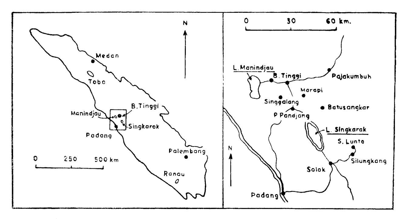
The area of Lake Singkarak can be reached easily by car from Padang Pandjang which is situated right in the middle of two main cities of Bukit Tinggi and Padang (see Index Map). A small villa owned by Hotel Adilla near Umbilin and the guest house of the Umbilin coal Mine in Sawah Lunto served as comfortable basecamps. The road which connects Padang Pandjang and Solok which goes along the eastern shore of the lake is fairly good whereas an unpaved road only accessable by jeep-goes along its western shore.
*) Dept. of Geology/Geophysics (ITB)-Indonesia.
VOL.
က
No.
PROCEEDINGS 1970
Fig. 1. Index Map of Singkarak Area and Surroundings
M.T. ZEN 3
Generally, the geology is reasonably well exposed and by clear weather the morphology of the entire area can be observed from several points situated on mountain slopes which flanked both sides of the lake.
Herewith the author wishes to thank CPI-Oil Company for the aid and services rendered to him which made this trip possible. Special words of thanks are directed to Mr. Kropschot, Acting Manager Exploration Division of CPI-Oil Company who showed a keen interest in the geological problems of Central Sumatra in general, to Mr. Kamal whose connection and good relationship with the local authorities made the trip easier and last but not least to Dr. Felix Heser who helped the author clarifying many problems encountered in the field through useful discussions.
THE SUMATRA RIFT ZONE
The purpose of this paper is to discuss the origin of Lake Singkarak. Since it will be shown in the next chapter that it is directly connected with the main rift zone of Sumatra it is not out of place to give a short introductory discription of the Sumatra Rift Zone.
Previous authors such as Westerveld (1952), van Bemmelen (1949), Verstappen (1955, 1961) and Katili (1967, 1969) have ascertained the existence of a 1650 km fault zone which runs along the untire length of Sumatra from the Semangko Bay in the SW to the tip of Atjeh in the NE. This zone is called Semangko fault zone by van Bemmelen (1949) and Great Sumatra fault trough system by Westerveld (1952). Van Bemmelen (1949) as well as Westerveld (1952) ascribed vertical displacements to this faults zone, whereas Katili (1967, 1969), based on literature study offered evidences which suggest horizontal movements along this zone.
Geologic and tectonic history of the Sunda islands shows that as early as the Neogene the Sumatra and Sunda orogens were divided into longitudinal fault blocks by the development of an elongated graben zone and parallel structures of a similar kind, which cut through the Mesozoic fold sytem in North and Central Sumatra (van Bemmelen, 1949 and Westerveld, 1952).
Field evidences in the Padang Highlands and works of previous authors suggest that this fault zone is not a continuous one. Besides, vertical as well as horizontal movements occur along this zone. So it is more proper to call it Sumatra Rift Zone, analogous to the East African Rift Zone.
The graben structures originated by the collapse of the Barisan anticline which happened in the Tertiary. This is indicated by the existence of Paleogene beds with fish remains below old Miocene coal-bearing strata in the Padang Highlands (Musper, 1935). It indicates deposition in an isolated depression. In the Semangko Graben in South Sumatra, the existence of the graben structure at the end of the Tertiary is ascertained by the presence of late Paleogene deposits near Semangko Bay (Westerveld, 1952). The graben morphology is most couspicuous in the Semangko Valley and in the Padang Highlands. In the llitter part the graben stl'Llcture can easily be traced from the Ivluaralabuh Valley in the south r.rntill as far as Suntpur-Rokan-Kiri Valley in the north.
Many parts of this graben zone becomes obscured by the cxtensive cover of pyroclastic sheets and volcanic ntantels from the Quarternary volcanic activities. Along tlris zone. where it is liee frotn volcanic cover, a large number of elongatcd depressions are lbund of which origin is largely still unknown. Most conspicuous are the Semangko Valley, the Kapahing Makakau Valley, the Ketahun Valley. the Kerintji Valley, the Muaralabuh Valley, the Singkarak-Solok trough. the Tarrgse Valley and the.Atjeh Valley. The occurrence o1' a large nuttrbcr ol' lirnralolcs antl hotsprirlgs itnd earthcprake cpicenters itr the Seniangko Valley and the Tarutung-Angkola-Gadis depression, 1he Sumpur ancl Mualalabuh Valley, indicates that the t-aults bordering this graben zonc are still active. Iu this paper only the Singkarak-Solok trough will bc discussed in detail.
MORPIIOLOCY AND STRUCTURE OF THE SINGKARAK .IROUGH
The Singkarak-Solok depression consists of two parts, the elongated northwest-southeast trencling Sinekarak Trough which is about 40 krn long and the rectangle shaped Solok Plain attached to it the southeast (Fig. 2)
According to the map sheet 36, Hind 1043 (Padang) issr"red by the US Arnry Map service, 2nd-Edition 1944, Lake Singkarak is about 20.7 km long with a maximum width of 7.5 kn. Its present waterlevel has an elevation of 362 m above sealevel with a maximnm depth of 268 m (Verstappen, l96l). According to Verstappen (1961) the bottom of the lake is flat. The topographic map sheets of Central Sumatra indicate that the lake is situated in the very lowest part of the Sunratra Graben of this section. Morphologically, L,ake Singkarak does not look like a cratel-lake, caldera or volcano-tectonic depression. It is quite diflbrent liom thc Manindjau depression in the north which is conrpletely surrounded by steep craterwalls built of alternating layers of pyloclastics and lava flows. Its shore line is relatively very straight. Its rvesterrt side is distinctly bounded by flat terraces and scarplets.
The Solok PIain is only slightly higher than the lake level. lts altitude ranges fiom 387 m above sealevel in thc northwest to about 450 m in the southeast. From the bottorn of the lake its altitude ranges between 293 to 356 m. In the sontheast the floor of the Singkarak Trough rises abruptly to approxirnately 1,500 m above sealevel in the surroundings of Lake Baruh and Lake Atas which are at a distance of 35 to 40 km from the southern shole ol Lake Singkarak respectively.
M. T. ZEN 5
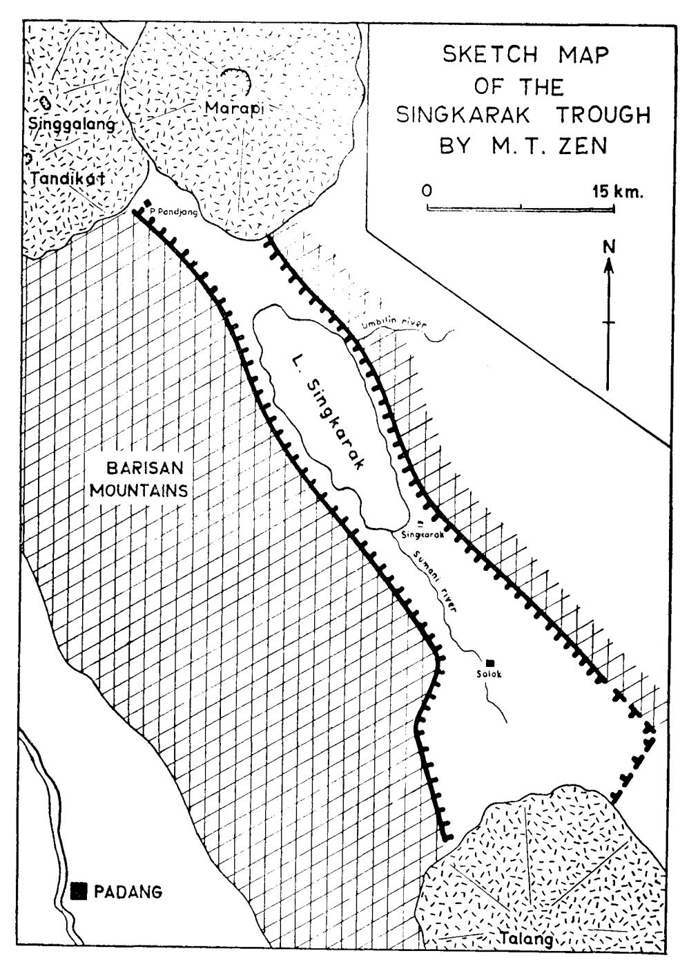
Fig. 2. Sketchmap of the Singkarak-Solok trough. INSTITUT TEKNOLOGI BANDUNG
In the NW the floor of the trough rises more abruptly than in the South. An elevation of 1,180 m above sealevel is reached at a distance of only 19 km from the northwestern end of the Lake. This is the area where the products from the younger Marapi abud against the foot of the Singgalang volcano, forming a broad saddle which consists of pyroclastics and lava flows. To the north the terrain slopes gradually down towards the tuff plateau of Agam.
Most of the small rivers in this area flow towards the Singkarak lake, including those rivers in the Solok Plain, but the lake itself is being drained eastward by the Umbilin river which incises its course through the off shoot of Bukit Padang mountains. Valkenburg (1921) mentioned the existence of a dry valley to the east of Solok. Evidently the Solok Plain once drained eastward via this deserted valley and the Lasi-Pumuatan river which debauches into the Umbilin river many kilometers down-stream. The bottom of the dry valley is at 410 m above sealevel. It is more or less at the same elevation of the higher terraces of the Umbilin outlet of Lake Singkarak.
Most probably the Soemani river followed this dry valley formerly but was forced to flow towards the Lake later on by subsidence of the trough bottom.
To the east and west, the Singkarak Trough is bounded by steep fault scarps. A number of scarplets and terraces flanking the lake on both sides can be distinguished very clearly in front of the fault scarps.
Indications of normal faulting around Lake Singkarak are numerous. Along the road to Batusangkar which partly follows the Umbilin river 6 normal faults parallel to the lake are found within a distance of less than 2 km. The faults are indicated by a repetion of fine layered lake deposits and volcanics. Obviously the Umbilin river follows another transverse fault indicated by the presence of tilted younger limestone layers adjacent to the lake deposits not far from Air Tanang village.
Along the road from Singkarak village to Suilt Air several tilted blocks dipping towards the east are encountered in the surrounding of Panorama Lama.
Also along the west side of the lake indications of normal faulting are found. Slickensides are found nearly on all older rock surfaces exposed in small streams such as limestones, phyllonites and schists which are supposed to be of Permo-Carboniferous age (Musper, 1929).
In the small stream of Muarabuluh several faults are found running parallel to the lake. One, trending N 332E/45, brought the younger volcanics adjacent to the schists and dolomitic limestone which is of Permo-Carboniferous age. In this area, where exposures are plenty, strongly deformed rocks are found in many places.
According to the mayor of Singkarak (oral communication, 1970) the river of Muarabuluh did not exist before 1961. It came into being during a huge landslide wich caused a "Bergsturz" which swept many houses and school building into the lake. The mayor further stated that this type of phenomena
N{.T. ZEN
occurs ..quite" frequent around the lake area. If it is true this might indicate that the fault is still active in this region.
Travclling around the lake gives one the impression that volcanic products are not predominant in the "rock economy" of Singkarak. Rock flagrnerrt found on the shore are mostly older rocks like schists, shale, slates, gneisses, and dolomitic limestones. 'fhe small terraces and scarplets on the westside betrveen the villages Kota Baru and Saningbakar are overlain by a thin cover of young volcanics consisting of andesitic to dacitic lava bouldcrs or tulfs which yield off light red soil when u'hethered. Also the hills on the southeast sidc of the lake are overlain by the sanre typc of rnaterial, The light red cover of the ten'aces aud scarple ts alc distict fronr both sides of the lake. The volcanics are not distinctlv corrnected with a paLticular erurptiou center. So there is a possibility that they have bcen issued fronr fissures found on both sides of thc lake. BLrt there is rro proof whatsoever for this assumption.
On thc nolth end of the lirke the glaben is filled by pyroclastic flow clcl.losits. ltconsists of sand, lapilli. scoriae lava fragrnents !tnd ash.
Thcse banks of pyroclastics show 14'-16" dip towards the lake. Goocl cxposurcs are found in Sumur. Thc sarne type ol deposits are also forrncl in thc rilhgc Batipu Atas (along the road fron.r Batusangkar to Piiclang Pandjang). Here, tlrc pyroclastics are obviously connccted with thc Marapi voicauo. ltt this area exposures of lava florvs alternating witlr pyroclastics are tturrtcrously lbund.
A pyloclastic florv dcposit of the sanre structure Arc also found irr tlrc quarrics of llatang Arus not far fronr Alahan Parrdjang in thc south. Sirrcc Mt. Talartg is the closest active volcano in the region it is reasonable to assurnc that thcse pyroclastic dcposits were ploclrrccecl by the Talang volcauo.
CONCLTJSION
Eviclcnccs encountered utrtil now suggcst that the Singkarak-Solok Iroug:h is a graben. lt is part of the Surnatra Rift Zone. Lake Singkurak itscllcarrc inlo existcnsc by the clanrnring process caused by volvanic nratclia! filling in both ends of the graben. lt is quite eviderttlrat the glabcn canrc into cxistcnce plior to the volcartic phase which produced the pyroclastics.