

INTRODUCTION
History of Dieng Geothermal Project
The idea of utilising natural steam for generating electric-power in Indonesia is not a new one. The first was launched by J.Z. van Dijk (1918). Escher (1920) criticised van Dijk's opinion strongly. According to Escher (1920) most solfataric fields in Indonesia are situated rather high, the surface
*) Geology Department, Institute of Technology Bandung.
areas of these solfataric fields are small, whereas drilling processes in volcanic areas are extremely difficult to execute because of the corosive action of gases. On the other hand, Taverne (1925) was more optimistic. His optimism was based on the good results gained by Italians in Larderello. The most optimistic view however was offered by van Bemmelen (1928) who visited Larderello in 1927.
The first exploratory drilling in the solfataric field of Kawah Kamodjang in western Java was executed in 1928. The results were considered not very promising. Until the disruptive years of the Pacific war nothing was done to promote further developments of geothermal plants in Indonesia.
In 1966, however, a three men team sponsored by Unesco wrote a favorable report on the possibilities of utilising geothermal energy for commercial purposes (Tazieff et al., 1966), especially the Dieng area.
Attracted to the authors short note and several popular articles on the possibility of utilising geothermal energy for generating electric-power economically, the Institute of Power Research in Djakarta authorised the author to carry out a preliminary survey on geothermy in Java. The purpose of the work was to locate hyperthermal areas in Java and to recommend the necessary plans for action. This preliminary work singled out several areas for further investigation under which the thermal area of Dieng-Batur volcanic complex was placed very high on the priority list (Zen, 1968). Financial difficulties however prevented the execution of a more detailed field operation.
In the same year a French private company (Eurafreb) was attracted to the same problem and sent a two men team to make a survey in Java and Bali. Eurafreb reported (1968) the same findings already reported by the author in 1968. By one of other complication Eurafreb abandoned its plan.
In 1970 US-AID stepped in. By the combined efforts of the Institute of Power Research, US-AID, the Institute of Technology in Bandung and the Indonesian Geological Survey, more systematic investigation including geological, geochemical and geophysical methods were applied to delineate the thermal belt in the Dieng Mountains and to estimate the volume and extent of the reservoir. In January 1971, the Evaluation Team decided to go ahead with the plan and proposed six sites for the exploratory drilling work due to start in June 1971.
Geographic Position and Location
The Dieng-Batur volcanic complex is situated in Central Java, 65 km S. 70° W from the main city of Semarang (Fig. 1). This area can be reached from Wonosobo or from Bandjarnegara through Karangkobar. However the only road access during the rainy season is from Wonosobo.
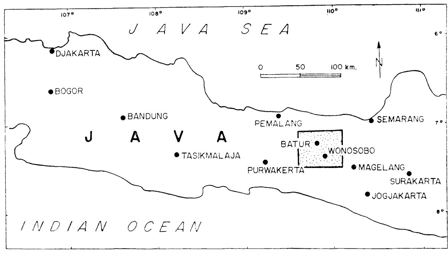
Fig. 1 Index map showing the location of the Dieng Mountains.
The Dieng-Batur Volcanic Complex, better known as the Dieng Mountains, forms part of a chain of Quaternary volcanoes built on top of the eastwest trending geanticline of Java. It comprises volcanic peaks which rise to 2200-2565 m above sealevel, enclosing an upland area (1600-2100) of moderate topographic relief. The surface drainage of this upland area (45 km²) is primarily to the southwest. Rainfall is reported to be in excess of 300 cm per year.
Acknowledgement
The author is very grateful to Drs. Patric Muffler, Montis Klepper, Mr. Dallas Fowler, Mr. Vincent T. Radja and Mr. Djajadi Hadikusumo for the useful discussions carried out during the field trip to the Dieng Mountains in January 1917. The author also wishes to acknowledge all the facilities extended to him by the Institute of Power Research in Djakarta and by the Geological Survey of Indonesia.
VOLCANIC GEOLOGY OF THE DIENG-BATUR COMPLEX
The Dieng-Batur volcanic mountains consist of a complex of late Quaternary volcanic vents which originated at the junction of two major fracture zones; the first one is an east-west trending zone, extending due west from the Dieng Mountains 50 km to the gigantic volcano of Mt. Slamet, and the second one consists of a row of young cones (Sindoro and Sumbing) which extends south-east of the Dieng mountains for 25 km.
It is obvious as stated by Umgrove (1929) and Neumann van Padang (1936) that the Dieng-Batur volcanic mountains are not a single volcano but rather a volcanic complex which consists of numerous separate extrusions, either a pyroclastic cone or a tholoid. Laharic as well as tuff breceias are found in great abundance. The elongated appearance of this complex is the result of a continuous shifting of eruption centers.
For the Dieng Mountains there are no analytical ages, neither a fossil control. However, it is very reasonable to assume from their appearance that all the volcanics found in this area are of Quaternary age. Petrologic data (Neumann van Padang 1936), suggest a sequence of magmatic differentiation which agrees fairly well with the age sequence deduced from geomorphologic studies (Umbgrove 1929).
According to their relative ages, the eruption centers in the Dieng-Batur Complex can be listed as follows:
- I. Telogo Mendjer
- II. Bismo
- III. 1. Srodjo
- 2. Binem 2134 m
- 3. Pangonan 2308 m
- a. Karvah Sikidang 2050 m
- b. Kawah Sigadjah 2050 m
- c. Kawah Kunrbang 20ti5 rn
- d. Karvah Sibauteng 2075 n''
- c. Karvah L)pas 2C0{) nr
- f'. Telogo Tertrs 205t1 nt
- 4. Merdodo
- 5. Pagerkandantg 2240 n
- a. Kawah Pagcrkandang 2075 rn
- b. Krwah Siparidu 2065 m
- c. Krwah Siglagah 1950 nr
- d. Kawah Silcri 1875 m
- 6. Nogrisali
- ]V. l. Butak 2202 m
- 2. Petararrqan 21.15 m
- 3. Telogo Dringo 2080 rn
- a. I(alvah Tjokrodimuko
- V. 1. Pakuwodio 2398 m
- 2. Kendil
- 3. Kunir
- 4. Prarnbanan
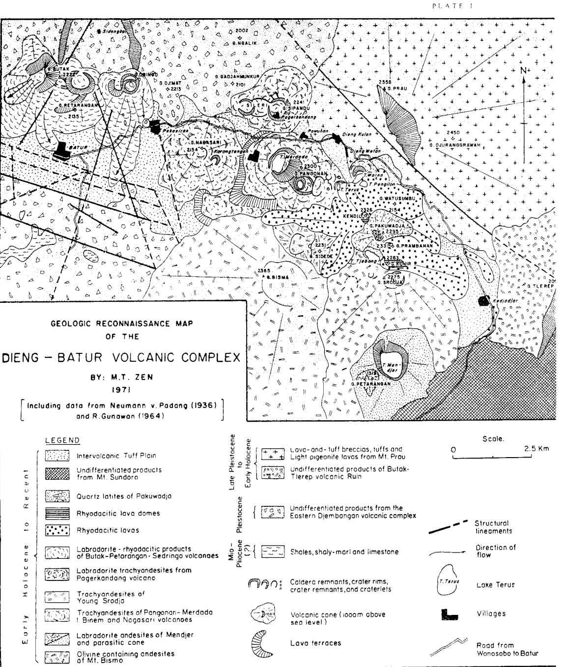
T'hc accrrmpanying nup (Platc I.1 of the Dieng-l]atur arca shows thc following conspicuous features:
- l. the wide distriltrtions of explosion craters rvhich show a cjistinct trend in their arrangenrent.
- 2. atr east-westrending volcarlic linearnent sor.rth of Baiur.
- 3. a lineament extending northn'est from Mt. Butak to Pagcrkundarrg.
- 4. a structural linearnent bcrtween Batur and Nagasari.
- -5. altother strLrctural linearnent trending northwest-southeast rvhicl-r bounds the thcrn.ral belt of Pagerkandang-Sikidang.
- 6. the explosion craters of the Pagerkarrdang-Siliidang bclt lintrting conspicr.rously northu,est-southeast u,hereas thc cxpltlsioll cratcrs north of Batnr nrns east-west.
Surface Thermal Manifestation
Strong lirmarolic and solfataric activities and phreatic or hy<!rothermal erttptions which still occur frecluently in the very recent timc are confined in ai-r area approximately measuring I I x 4 km wide trending rvest-northwest.
Thc existencc of nurncrous explosion craters, rnaars and craterlakes indicates abuudant near sulface heat and hot water. Formerly, rnost explosive
activities have been described as phreatic eruptions. Muffler (1971) have shown that similar phenomena at Yellowstone National Park in the US were formed merely by release of confining pressure on the hot water hydrothermal system. These type of activities were called hydrothermal by Muffler (1970).
RESULTS OF THE GEOCHEMICAL SURVEY
Geochemistry has become a method of paramount importance in geothermy. One of the aims of geochemical methods used in geothermy is first of all to establish whether the geothermal system in consideration is a hot water system, i.e. a system of hot water and steam or a system of dry steam, i.e. a system which is solely vapor-dominated.
In a hot water system, the upward transfer of water and heat is caused by the movement of liquid water. In a vapor-dominated system, however, this occurs through the movement of steam. Since chlorides are not soluble in steam with temperatures below 300°C, the existence of a hot water system can be established if the surface springs yield an appreciable amount of chloride to the order of more than 50 mg per liter (Truesdell, 1970).
During the geochemical survey, Truesdell (1970) found 125 mg/1 of chloride at Kawah Sileri and 470 mg/1 at Pulosari. Since previous experience has established the fact that springs showing a high chloride content could not be associated with a dry-steam system at depth (Muffler, 1971) it is to be concluded that in the Dieng mountains we have to deal with a hot water system.
Further, Truesdell (1970) concluded that at less than 200 m, there might be three geothermal systems in the Dieng mountains, which can be expected to be interconnected at greater depths. Of these presumed systems, the one found at Pagerkandang which has an surface area of 25 m<sup>2</sup> is the largest. Next to this system are the smaller ones of Sikidang near Dieng Kulon and of Tjandradimuka, near Pekasiran. Muffler (oral communication, 1971) is more inclined to think that the chloride-rich water collected by Truesdell at Pulosari represents a discharge from either the Sikidang or Pagerkandang system.
Water samples collected from Kawah Sileri and Pulosari springs have been analysed for their SiO<sub>2</sub> contents by the USGS laboratories at Menlo Park (California). The silica values of both springs are found relatively high, namely, 125 and 177 mg/l respectively (Muffler, 1971). Therefore, subsurface temperatures of 150°C and 170°C respectively can be inferred for both springs (Muffler, 1971). Further Truesdell (1970) concludes that from the low Cl values and the only slightly acid pH values of all the Dieng fumarole condensates and the flowing springs that the hot water at depth beneath Dieng Mountains is not acid, and should present no corrosion problems during exploitation.
RESULTS OF THE GEO-ELECTRICAL SURVEY
General Statement
In July and August, 1970, Group Seven, Inc. (Jacobson et al., 1970) conducted an Electrical Geophysical Survey in the Dieng Mountains under contract to the Agency for International Development and on behalf of the Indonesian Directorate General for Power and Electricity and the Indonesian Geological Survey. This work was planned to delineate the subsurface extent of the hot-water reservoirs feeding the surface hot springs and fumaroles.
The most recommended geophysical procedure to be used in delineating a hot water reservoir up till now would be profiling with the direct current resistivity method, combined with direct current resistivity soundings to depth of the order of 3 km (Banwell, 1970). The first step was profiling with the Schlumberger electrode array along the road running from Dieng Kulon to Batur. Electrode separations of 100 to 500 meters were used which provided a depth of investigation of roughly the same size of 100 to 500 meters.
Instead of a Schlumberger profiling, Group Seven Inc. (Jacobson et al., 1970) has found that detailed mapping of the electric field about a fixed dipole source is a more effective means for mapping a thermal reservoir since Schlumberger profiling is difficult to use in mountainous terrain such as the Dieng Mountains, besides, it provides ambiguous results if there are rapid lateral changes in resistivity, as are frequently associated with geothermal systems.
Accordingly, two dipole mapping surveys were conducted, one about a dipole source located in the meadows south of the village Dieng Kulon, and the other about a dipole source placed along the Dieng-Batur road (Fig. 2).
The measurements were made at a distance of 1 to 5 km from such a dipole source which provided information on an average resistivity to a comparable depth. It is found that dipole mapping surveys are useful in delineating the geographical extent of deep lying hot-water reservoir. However, it provides little information on the variation of resistivity with depth. Once the extent of the reservoir is determined other means must be applied to determine the depth to the top and bottom of the reservoir.
Evaluation of Results
As stated previously, the electrical geophysical method is aimed at delineating the boundaries of conductive areas associated with the occurrence of a subsurface hot water reservoir. The boundaries are depicted in (Fig. 3). Here the 5 ohm meter contour is considered to be the outer most boundary of the region where the electrical resistivity of the rock has been altered extensively by thermal activities. The main areas of thermal activities are the regions enclosed within the 2.5 ohm meter contour. The results indicate three
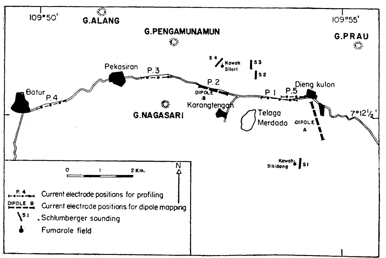
Fig. 2. Location map for electrical geophysical surveys in the Dieng Mountains by Group Seven Inc. (Jacobson, 1970).
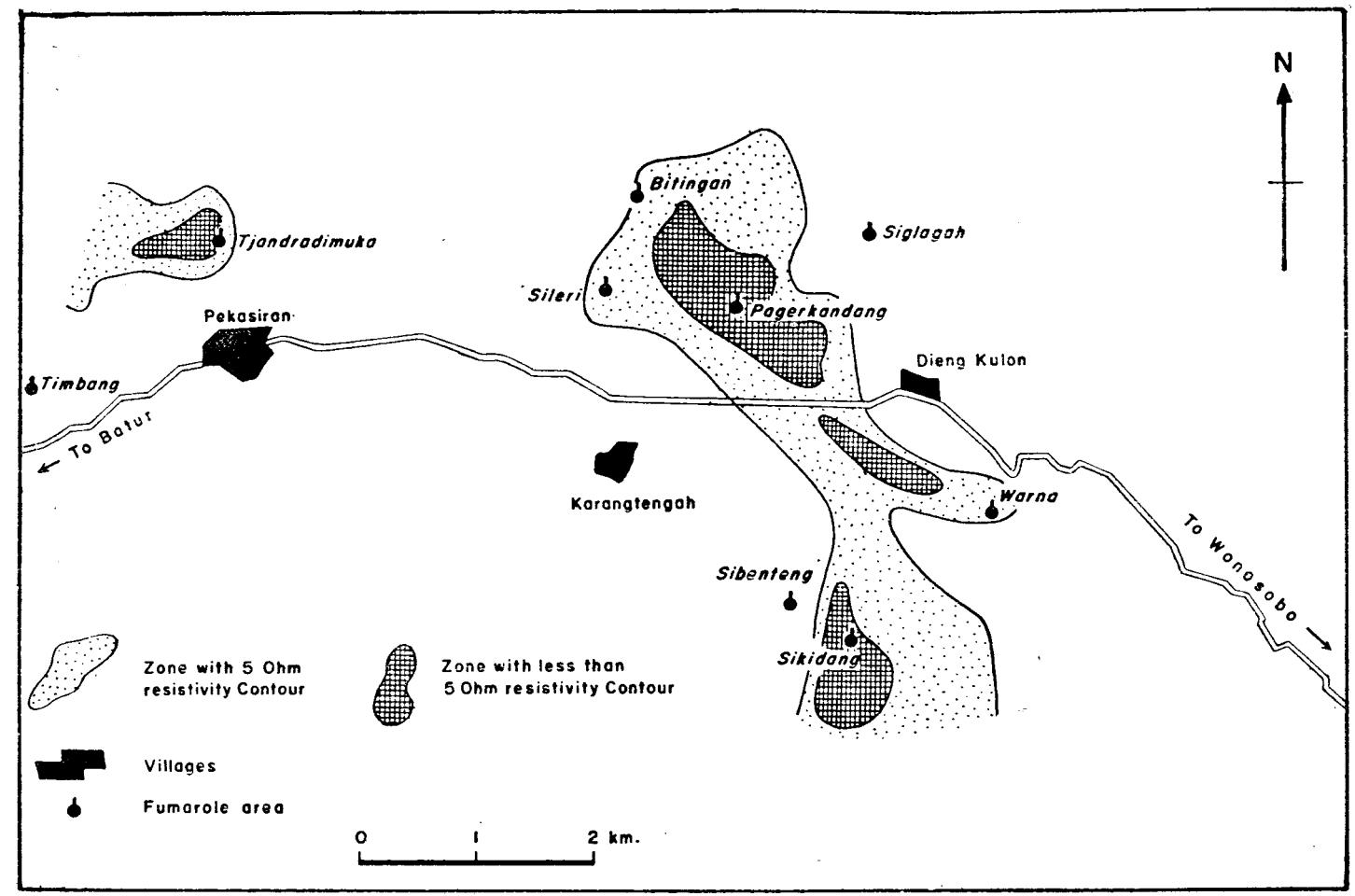
Fig. 3. Map showing low resistivity zones obtained by Group Seven Inc. Survey. (data from Jacobson et al., 1970, modified by Zen).
such areas within the thermal belt; one is centered about the Pagerkandang fumarolic fields, one about the Sikidang crater, and a third is located south of Dieng Kulon. The first two areas show considerable surface thermal manifestations, the central area, however shows very little or no surface manifestation.
It is a wellknown fact that the resistivity of a porous rock is determined almost entirely by the amount of water contained in that rock and the resistivity of the water. The resistivity of water is in turn determined by its salinity and temperature. The variation of the resistivity in volcanic rock as a function of water content which is assumed to be equivalent to its porosity, should be similar to that shown in Fig. 4 [a compilation of data for volcanic rocks from the southwestern US (Keller, 1960)].
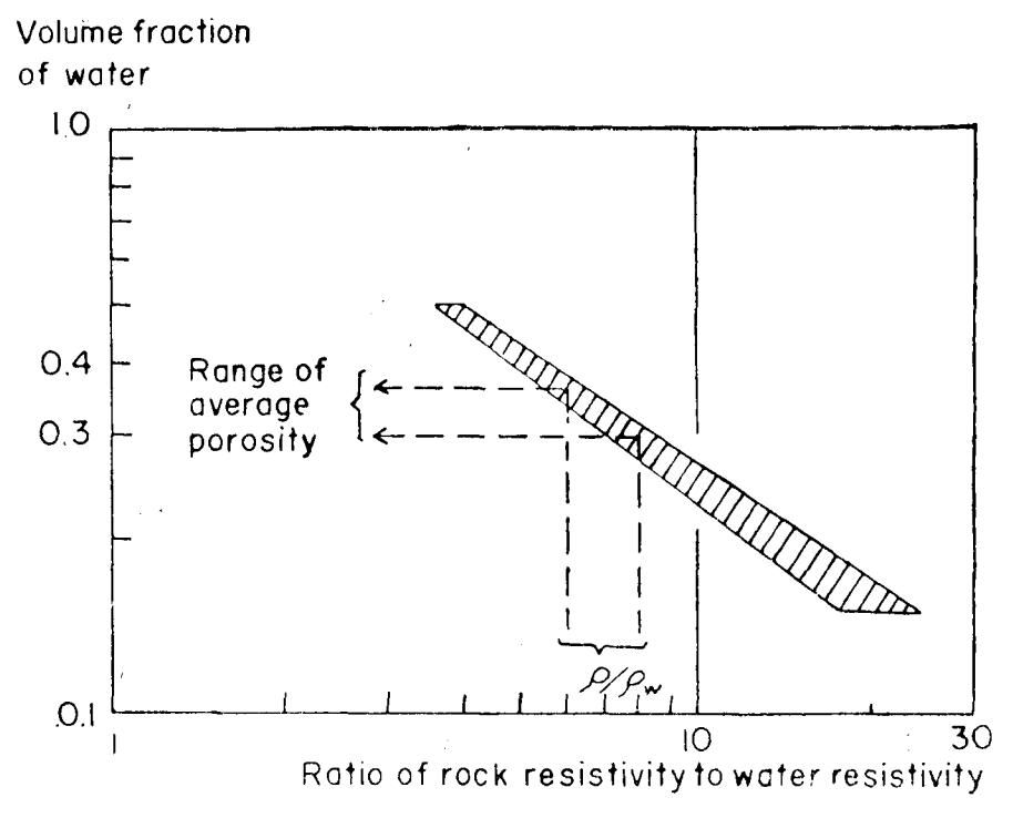
Fig. 4. Empirical relationship between rock restivisity and water contant for typical pyroclastic rocks (Keller, 1960).
The porosity of a volcanic rock may be estimated from its resistivity if the resistivity of the water contained in the pore space is known.
The geochemical results (Truesdell, 1970) indicate that the geothermal fluid at depth contains 770 mg/l of chloride in solutions. This corresponds to a resistivity of 1.5 to 2.0 ohm meters at 20°C (Keller et al., 1966).
To appraise the significance of these data representative values of resistivity from the field measurements must be selected. To do this, Jacobson et al., (1970) made use of a histogram of the measured values (Fig. 5). Based on this, Jacobson et al., (1970) concluded that the median value of 1.3 ohm meters applies to the hot water saturated rock in the centers of thermal activity, the median value of 6 ohm-meters applied to the moderately altered and heated rock in the belt containing these centers of thermal activity, and the median value of 12 ohm-meters applies to 'normal' volcanic rocks outside the area appreciably affected by the thermal activity.
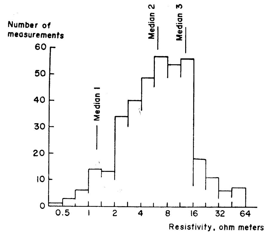
Fig. 5. Histogram of apparent resistivity values determined by dipole mapping. Resistivity scale is log normal (From Jacobson et al., 1970, Group Seven Inc. — Report).
THE GEOTHERMAL SYSTEM OF MT. DIENG
The thermal areas outlined by surface manifestations and the belt of anomalously low resistivity delineated by the geophysical survey by Group Seven Inc. (Jacobson, et al., 1970) are obviously related to the major northwest-southeast trending lineament zone indicated in Plate I. The scant geochemical data and the rather incomplete geophysical information allow quite a roorn for speculation. Nevertheles it is quite reasonable to suppose that those manit'estations are connected at depth to fornl the Dieng Geothermal system. Besides, this thermal belt coincides rvith the zone of volcanic lineaments which extends from Pakunradja to Pagerkandang whereas the Tjandradirmrka therrnal systenr is confirred within the zone of structtrral lineaments west of Gn. Nagasari.
Frorr, air photos interpretation ancl field observation it seents justified to assume that both geothermal systems which show most intense therrnal manifestation are at the junction of two lineament zones, namely, thc northwest-trending lineaments found on the crest of the Dieng-Batur l\{ountains trending east-west.
Based on the model of Larderello, Tazieff et al. (1966) and Faccaand Tonani (1961, 1966) considcred the existence of a cap-and-reservoirocks lrcside tr heat source as an ilhsolute condition for the existence of a conrmercial steamfield. This model seems tr: break dovrn fol the Dieng Geothermal systen':. During his short visit in the Dieng Mountains, Tazieff et al. (1966) placed a too much entphasis on the possibility that the lacustrine sedirnents of Dieng Plateau propcr would plav the role of a cap rock. In fact the distribution of the lacustrine seCiments at Dieng Plateau proper is very limited in extent whereas the thermal belt rvith the trnomalous low resistivitv delineated by electrical-geophysical mcans reaches far beyond the linrit of Dieng Plateau proper. ln the area on Pa.gerkanclang as well as in the area of Tjandradimuka this lacustrine sediments, expected to play the role of a cap rock by'fazieff, are completely missing.
The association of the two geothermal systenls rvith zones of weakness rvhich is manirested clearly at th.e surfarce by fracturing and volcanic activity suggest that effective permeability at depth in the geothermal system will be due to interconnected fractures rather than by the existence ofa reservoirand a cap rock. This has also been the case rvith the Gey'sers in California pointed out by Mufflcr (l9ll).
It seen.rs that the caprocks in the sense of Facca & Tonani (1961, 1954) provides an idcal condition, however, it is not a conditio sine quanon for the eristence of a geothermal field. In general, the high pressure flLrids of a geotherilal field are confinecl by the weight of the overlying water in interconncctcd pores and fractttres. This intplies that the pressure measured in geothermal fields in general follow the hydrostatic pressure curve of a colunrn of water everywhere at the hoiling points.
On tbe other hand, volcanics (tuff, tuff'-and-laharic-breccias) could be lveathered more easily through the action of solfatara and fumarolic gases which might result a self-sealing process after an elapse of tinie and produce the so called "cap rock" ovcrlying a thermal field.
In petroleum engineering problems, a reservoir is defined as "that portion of a trap rvhich contains oil and gas as a single hydraulically-connected system" (Craft et al., 1959). Whether we can speak of a reservoir in this seuse for the geothernral system of I\{t. f)ieng is still questionable.
It is regretful that thc geo-clectrical measurements have not been extended far enough to the northwest to see whether the belt of low resistivity found northwest of Batur is connected r,vith thc lou, resisiivity belt of Pagerkandang-Sikidang. tf that was the case the geothermal system of Mt. Dieng has a much larger "reservoir".
The area enclosed by the three main resistivity lou,s of the Pagerkandang-Sikidang belt has been estimated by geo-electrical methods (Jacobson, et al. 1970) to bc 2.5 to 3.0 kilometers. The depth extcnt of the reservoir be<ls appears to be at least 2 kilometers. So the volttme ot'the rescrvoir can be cxpectcd to be 5 to 6 cubickilometers. Of this volume about one-third probably is warer through which heat nray be produccd to the surface. The heat energy rr,hich would be available on cooling this liquid to 50oC rvould be 3500 megawatt-years per cubic kilometers of resevoir. Becausc of the inefficiencies in conversion it is not possible to have all this energy in the form of elcctrical energy. A more realistic figure would be 900 megawatt-years per cubic kilometer of reservoir (Banwell, 1970). So, the energy available in the eastern Dieng geotherma! system uith a rcservoir of 5 to 6 cubic kilonreters can be expected to produce electricity of 4500 to 5400 megawatt-years theoretically. Jacobscn et al., (1970) however estimated that the eastern Dieng geothermal system can support a polver production of 200 megav,'atts for 25 5'ears, or of 100 nregawatts tbr 50 years.
The nrost fundamentirl question is o1'course how fast the liquid can be withdrawn frcm the reservoir, provided that the forenrentioned geophysical inferences are correct. Our experience in this field is based on oil field production. Volcanic rocks, however, might be dift'erent as far as production performances are conccrned. The author of this paper is rnore inclined to think that the conditions prcvailing for each geothermal field might be unique which requires uniqne solution and answers.
EXPLORATORY DRILLING WORK
Drill Sites
Based on all these data the geothernral project of Mt. Dicng has been recommended. to proceed to phase II, nantely the erploratory drilling work which u'ill drill to a depth between 200 and 600 meters. Therefbre, six drilling sites have been selected. These are in the areas of:
- l. Pagcrkandang
- 2. Telaga Terus
- 3. Pawuhan
- 4. Sekunang
- 5. Sidolok
- 6. Dieng Wetan.
The purpose of this exploratory drilling worl: is to test the geologic, geophysical, and gcocheurical indicators, determine temperature gradients from lC0 to 200 nlelers, collect sanrples olfluids and gases at various depth arrd finally to collect core sarr,tr lss at 5 meter intervals as the u'orl< Drogresses.
If the teurperature and chemical indicators of the 200 meter holes ryere found favorable, one or twc of the holes rvill be cleepened to 650 meter. The purposc of this rvork is to find out the base tcnrpcraturss which is mostly im-Dortant, deter'nrine whether we have a system of dry steam or a system of hot water, c<lllect fluids at greater depths and finally to dctermine the physical chnracteristir-s of the "rcservoir" rocks.
Hazard of Recent Activities
One question worth considering in establishing this thermai project in the Dieng lrrea i:; of conrse the fact that this volcanic con:plex is still unstable. Fruptions, phreatic or hydrothernral in character as well as seisrnic tremors occur rather lrequently. lt is of course possihle that the scisn.iic tremors and the entptions in the crater lakes are due to the hot watcr systeln itselft rather than of "volcanic" in origin.
Tbe Pakulvadja volcano erupied in I925, strong phreatic or hydrothern'lal ertrpl.ions occurted in 1786 at ljartdradinruka solfataric fields, jn 1928 and 1939 in the Tinrbang explosion craiers, and in 1944 in the Sileri explosion craters of the Pagerkandang volcano. A minor oruption occurred in the same cra ter in 1964. Solfatares are nrost strongly developed in the Sikidang f ield of the Pangonan volcano, jn the Sileri explosion crater ofPagerkandang, and in the Tjandradimuka field of the Sedringo volcano. They are associated rvith fumaroles, mudu.ells and hotsprings. Furnaroles are mL)st widespread along the southern and southeastern craterwalls of Pagerkandang a.nd along its outer slops. Strong mofettes occur at the bottom of thc southern Djimat crater, in the 'Iimbang crater and in Gua Upas explosion cratr:r of the Pangonan-lt'lerdada volcano-
Precaution must be taken to prevent unnecessary lost of human lives and destruction to valuable structures.
While the eroloratory Crilling is in progress the author is of the opinion that it is highly nccessary and strongly reconlmended to install a seismograph or portable seisnioscope to detect earthquake tremors in this area.