

INTRODUCTION
Authors such as Van Bemrnelen (1949), Katili (1967, L970, 1970a), Westerveld (1952) and Zen (1970) already mentioned the exlstence of a 1650 km fault zone dissecting the enEire length of Sumatra. Katlli (1970) called it the Great Sumatran Fault system and Zen (1970) prefered to call it the Sumalra Rift Zone. The r"rord rift here is used to denote a rnorphology dissected by fault scarps wiEh graben structures and it does not denote the mechanism of the fault itself. According to the most recent Plate Tectonic concept this Sunatla Rift Zone and the deep sea trench which runs parallel to it ln t.he west ls nothing else bu! a shear and convergen! juncture co accomnodace the southeast ward motion of the Eurasian plate and lhe northward mott-on of the Australo-Indian Ocean plaEe.
Along this zone, shear motion predominates, although dip sli" phenomena are also observed, especially at places where the fault traces come to an end.
Van Bemmelen (1949) as well as Westerveld (1952) considered this fault zone to be inportant ln the process of volcanism for the island of Sumatra. Indeed, nunerous QuaEernary volcanic cones, volcanotectonic depressions as well as the discribution of extensive sheets of pyroclastics are found along the entlre length of the fault zone.
According to Katili (1967, 1970 and 1970a) the Sumatra Rift Zone is a sysEem of active transcurrent Fault zones. Field evidences suggest that there is a consistent and continuing presence of right-lateral wrench faulting along chese zones. Zen (1970) found graben strucEures in the Singkarak trough.
A11 rhe active or recently active volcanoes in Sumatra are aligned directly over or very close to active systems of faults which belong the main Sumatra Rifc Zone.
writing about Ehe "Acid fissure eruptions in the Semangko Zone of Central Sumatra", van Bemmelen (1949) said : "This part of the Semangko-Graben system in Central Sumatra is also a typical rift structure. The acid tuffs, exposed in 'Karbouwen-gat' (spellunk of wacer buffaloes) near Fort de Kock (Bukit Tinggi) were probably produced by fissure eruptions in this nedian rent, like tlrose of Pasumah, Ranau and the Semangko Valley further South",
Westerveld (1952) too said that the material was slmilar to Ehe incandescent clouds of the Katmai type.
Sponsored by Caltex Pacific Indonesia the author revisited the Padang Hlghlands in 1970 and carne to see the origin of the tuff plateaux in Central SurnaEra under a new light, the tuff plain around Rrkit Tincpi in narlicular.
Finally, lhe author expresses his sincere gratitude to Drs, Sukendar Asikin from the Geology Department of ITB for reviewing thj; manuscript and for giving valuable suggestions. However, the author is so.lcly responsihle for the content of this paper.
THE PYROCLASTIC PLATEAUX IN THE PADANG HIGHLANDS
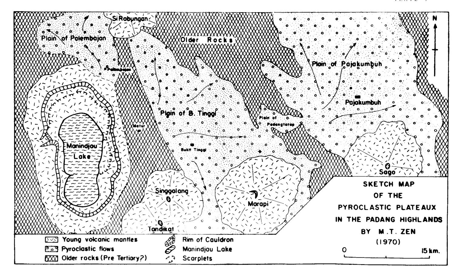
Three extensive pyroclastic plains—are found North of Mt. Sago and Mt. Marapi. These are—the Plain of Falembajan, the Plain of Bukit Tinggi—and the Plain of Pajakumbuh. Between—the Plain of Pajakumbuh and the Plain of Bukit Tinggi—another smaller one—is found, namely the Plain of Padang Tarap (Plate I).
According to Verbeek (1883, p. 525) these tuff mass must have been deposited in lakes. If this assumption was true we must assume the existence of three large diluvial lakes which were connected with each other by waterfalls, descending gradually in elevation towards the East and surrounded by gigantic volcanoes. According to the present morphology this is very unlikely.
In a sense the Plain of Pajakumbuh could be formed from a lake which drained through the valley of Buo. The activity of Mt. Sago gradually must have dammed the river and formed the "lake of Pajakumbuh". Later on the river must have incised another course and drained the lake. This is not the case however with the Plain of Bukit Tinggi or the Plain of Palembajan.
If these tuffmass which build the present tuff plains were deposited in water, this will be indicated by some kind of stratification and by the presence of fossils. This is not the case, especially not with the Plain of Bukit Tinggi which is completely exposed in the famous cleft of Ngarai SiAnok right in the middle of Bukit Tinggi or Karbouwengat.
THE PLAIN OF BUKIT TINGGI AND THE CLEFT OF NGARAI SIANOK
The pyroclastic plain of Bukit Tinggi is too extensive a plain to be formed from a lake deposit. The size itself already invalidates the argument. This plain descends gradually towards the west, bounded in the south by the volcanoes Marapi, Singgalang and Tandikat.
The most interesting part of the Bukit Tinggi plain is the presence of Ngarai SiAnok cleft. Here, the river SiAnok cut through the thick pyroclastic deposit and exposed a tuff profile of about 75 meters \(\frac{1}{2}\)
The presence of such a deep cleft in such a plain poses already a problem since this cleft is the only one of its kind found through the entire plain of Bukit Tinggi.
Generally, the pyroclastics which build the plains in the Padang Highlands are very pure and porous, especially the pyroclastic deposits around Bukit Tinggi as revealed in the SiAnok cleft.
The pyroclastic deposit is so porous so that it acts as a sponge absorbing water into it completely. In this way there is hardly any drainage along the surface since any superflous rain water disappears in the tuff. Automatically there is very little erosion. Still, Ngarai SiAnok is there, gaping like a miniature Grand Canyon.
Probably the acid pumice tuffs and breccias of Bukit Guntung (1,150 meter) and Bukit Palantar (953 meter) in the Manggani area, about 30 km NW of Bukit Tinggi belong also to the acid tuff plains of Central Sumatra which belong to the plio-pleistocene phase of volcanism, and van Bemmelen (1949) considered them to be products of fissure eruption. These tuff sheets cover unconformably the Tertiary formations, but they are certainly older than the younger quaternary
volcanoes, such as si Rabungan and Sago. The acld pumestone tuffs of Bukit Guntung can presumably be correlated in age with those of Ngaral SiAnok in Bukit Tinggi (Van Bennnelen, 1949).
Van Bemmelen (1949) stated further that the flssure eruptlons occured simultaneously with the plio-pleistocene arching of the Barisan geanticline. Thereafter, the more basic strato-volcanoes are built up such as Marapi, Singgalang and Tandikat.
n
i \' f
tt o)
Fotmation of Nganai SiAnok
How is the SlAnok cleft formed? As stated before, the pyroclastic deposit around Bukit Tinggi is very porous and acls as a sponge. But the Bukit Tinggi tuff is cur very deeply by the SiAnok river. The walls on both sides of the cleft are very steep,
Since the pure tuff deposirs absorbs water completely che superflous ground water drains to the North. It stays so long underground until they reach the normally irrcised part of the SiAnok river. So, Lte can inagine that the forrner incised SiAnok va11ey ended against the tuff wall with ground water seeping out from the wal1.
In this way Lhe existing wall of tuff wiII ret.reat and keep ics vertical position, The backward incission is caused by the groundwater itself. This process is clearly demonstrated in the SiAnok c1eft. The bottom of the cleft under the vertical tuff wall is wet. Many smal-l springs appear here. This is the groundwater which transports somc of the tuff and Ehe pumice fragments. The wall losts its support and tumbles down. Then comes the rain and carries away the debris formed in this way. Finalllr ir is transported by the SiAnok river.
If part of a wall does not tumble doL"n vertically rhe rain waler will carry away the accunulated debris such that finall.y the wall crumbles and becomes vertical again.
In chis way the depth of the SiAnok cleft depends on the base of erosion of Che incising river. Ihe tuff wall moves gradually by the attack of Ehe groundwater ln Elie direction of the main groundwater system wlrich gets its water fron tlre catchment area of the Marapi and the Singgalang volcano. So, tlre valley which is formed by backward erosion widens because of rivcr erosion and also by the subsurface accion of the groundwater. Tlris can be observed clearly in the field. At places where ttrere are bigger groundwater veins side ravines are formed which are moving backvard also. All the active side ravlnes still show groundwater spring at tl)e base of a steep end wall.
The pyroclastic deposit exposed aE Ngarai SiAnok does show sorne inLlicafion of stratificJtion in its upper parts. This js exposed i n some snaller branches oI thc canyon. TIle stratification is not horizonLal. In its deeper parts, betueen 5-7 meters from the surface Lhe straLificrtion disappears corrplctt'lv. The steep walls o[ \garai Si-Anok exl,ose ono homogcnorrs nass. It gives tllc impression as if deposited in one single blast.
r\s iar as 1r is expcrsod at Ngrrai SiAnok, the pvroclastic deposit is not rvclclcd nor dots it sl)ow somcr kind of zoning such as described bv Snritlr (I960).
!.iechrttticn of Erur:tion and t)r't.Jin
Three errrptive meclranisn have been proposed for extensive pyroclastic sheets like the type of the Padang Highlands pyroclastics.
.
These are the tuff flow or pyroclastic flow mechanism, the froth flow, and the ash fall. In Sumatra extensive pyroclastic sheets have been identified around Lake Toba, Lake Ranau, Lampung (South Sumatra) and in the Padang Highlands. More pyroclastic flow sheets have been identified lately in Indonesia (Zen, 1966). According to the author, we can not explain them by one eruptive mechanism. Every deposit or complex of deposits have their own eruptive mechanism. Some can be explained by flowage emplacement some others by ash fall.
The pyroclastic flow mechanism concept has its origin from nuees ardentes observations and also from reconstruction of the welded tuff deposits in the Valley of Ten Thousand Smokes by Fenner (1923).
Proponents of the flowage emplacement such as Marshall (1935, p. 14) and Gilbert (1938, p. 1851) believe that a welded tuff is emplaced as an avalanche of fine particles of viscous melt which are at high temperature and exsolve gas. The avalanche is believed to move solely by virtue of gravity like the nuces ardentes of Mt. Agung (Zen, 1964, 1964a). Such an avalanche of pyroclastics which is inflated by gas, would be fluid, and its emplacement would be very rapid. On coming to rest, the avalanche deposit would compact, it is supposed that the finely comminuted fragments of melt would retain sufficient heat to deform and weld (Boyd, 1961).
The author has observed numerous flows of nuess ardentes during the eruption of Mt. Merapi in Central Java and during the eruption of Mt. Agung in Bali. As of now no historic deposits emplaced in this way produced extensive pyroclastic deposit nor do they produced welded tuff.
Kennedy (1954) proposed that the welded tuff in Yellowstone has formed from "collapse froth flows". Kennedy pictured the erupting magma moving as an expanded lava froth rather than as an avalanche. Though this might explain welded tuff flow of smaller dimensions, many extensive pyroclastic sheets are known to be unwelded and which can not be explained by this theory.
Mansfield and Ross (1935, p. 309) however, concluded that the welded tuffs in southeastern Idaho were "sprayed or ducoed" over an erosion surface with a relief of 3000 ft. They found the thickness of the pyroclastics to be uniform, besides, they were independent of the underlying topography. These field relations seemed to invalidate the pyroclastic flow mechanism.
As far as the pyroclastic deposit of Bukit Tinggi is concerned, previous authors such as Van Bemmelen (1949) and Westerveld (1952) are of the opinion that it was emplaced by flowage from fissure eruption.
This explanation is very attractive and close at hand since this area is right in the middle of the Sumatra Rift Zone which dissects the entire length of Sumatra. Most of the active volcanoes of Central Sumatra are found clustering at intersections of fractures of the Sumatra Rift Zone and the obvious E-W trending topographic lineaments.
The author is of the opinion that the huge pyroclastic deposits in the Padang-Highlands were produced by the gigantic Manindjau volcano prior to its collapse to form the Manindjau Cauldron. The remarkable flatness of the Bukit Tinggi Plain and several flat pyroclastic terraces between Matur and Bukit Tinggi give the impression as if the whole landscape has been ducoed from the air by ash fall. The "Uniform" character of the deposit as revealed in Ngarai SiAnok suggests that the whole mass was deposited by one single huge blast. As the eruption waned, smaller blasts were produced and these were responsible for the several flat pyroclastic terraces found between Matur and Bukit Tinggi. (A more detailed paper on the origin of the Manindjau Cauldron and its products is in preparation and will be published shortly in this ITB Proceedings).
Unwelded State of the Bukit Tinggi Pyroclastics
Studying the pyroclastic deposit of Bukit Tinggi exposed at Ngarai SiAnok one can not help wondering why it is not welded. In this report welding is defined as a process which promotes the union or cohesion of glassy fragments. The degree of welding may range from incipient stages marked by the sticking together or cohesion of glassy fragments at their points of contact and within the softening range of the glass to complete welding, marked by the cohesion of the surfaces of glassy fragments accompanied by their deformation and the elimination of pore space, and perhaps ultimate homogenization of the glass (Smith, 1960).
Welding as previously defined will depend on many factors. The most important ones are: 1) initial temperature; 2) amount and composition of volatiles; 3) composition of ash and 4) load pressure. Further, welding will also be promoted by a) rate of cooling and b) rate of crystallization.
The first three variables control the viscosity of the glass (Smith, 1960a) and the load pressure is a function of density and depth in the deposit. Load pressure and viscosity on the other hand will influence the rate of lost of pore space. This is the only measure of the rate of welding. So, degree of welding ultimately will depend on: the rates of welding, cooling and crystallization, whereas the latter is related to the viscosity of the glass.
Perhaps the two most important factors which control the cooling history of pyroclastic deposits are the emplacement temperature and the thickness of the deposits.
Boyd and Kennedy (1951, p. 327) made the first attempt to produce welded tuffs by experiment. They found that crushed rhyolitic pumice from Mono Craters (California), welded at temperatures which range from \(775^{\circ}\) to \(900^{\circ}\text{C}\).
Boyd (1957) found that the presence of water vapor effectively lowers the welding temperature. Glassy rhyolitic volcanic ash from Yellowstone Park was sealed in platinum capsules with water equivalent to 0.45 weight per cent and hold for 80 hours under pressure of 52 bars. Under these conditions the minimum welding temperature was between 590° and 620°C. Increasing the time of the experiment to 2 weeks resulted in lowering of the welding temperature to between 550° and 590°C. Boyd found further that the same ash, dehydrated and without addition of water in the experiment, showed slight welding at 690°C after 72 hours at a pressure of 48 bars, and no welding at 655°C. From these and other experiments Boyd concluded that the minimum welding temperature in the presence of water vapor is about 600°C.
We know that heat losses during emplacement come from three different sources. These are: 1) radiation; 2) conduction to the ground and 3) conduction and convection to the atmosphere.
Dissipation of heat in these three ways will depend on many factors. The most important ones are the degree of turbulence in the moving flow, the time elapsed during emplacement, and the thickness of the flow.
The thickness of the pyreclastic deposit around Bukit Tinggi ranges between 75 to 150 meters. We know too that the heat lost during emplacement of a deposit is inversely proportional to its thickness.
If the deposit is emplaced by flowage and if the flow is laminar, the heat loss is insignificant. But, if there was turbulence within the moving flow, the heat lost in any interval of time would be greater, since hot material would be constantly supplied to the surface.
The sections at Ngarai SiAnok suggest that the emplacement is not by flowage but deposited from a huge single blast from the air.
The unwelded condition of the Bukit Tinggi tuff suggests that a considerable amount of heat was lost prior to its deposition. Even the lowest part of the tuff deposit exposed at Ngarai SiAnok is unwelded. So, the temperature of emplacement must be lower than the minimum welding temperature of 600°C.
The author suggests that most heat was lost by conduction and convection to the atmosphere during deposition from its source to the place of emplacement. When emplaced the temperature was already far below the minimum welding temperature to promote any welding.
| + | CITED REFERENCES | |
| Bemmelen, R.W. van, 1949 | : | The Geology of Indonesia, Government Printing Office, The Hague. |
| Boyd, F.R.& Kennedy, G.C 1959 | · , : | Some Experiments and Calculations Relating to the Origin of Welded Tuffs, Am. Geophys. Union Trans. v. 32. p. 327. |
| Boyd, F.R., 1961 | : | Welded Tuffs and Flows in the Rhyolite Plateau of Yellowstone Park, Wyoming, G.S.A. Bulletin, v. 72, p. 387-426. |
| Fenner, C.N., 1923 | : | The Origin and Mode of Emplacement of the Great Tuff Deposit of the Valley of Ten Thousand Smokes: Nat. Geogr. Soc. Contr. Techn. Papers, Katmai series, No.2, p.74. |
| Gilbert, C.M., 1938 | ; | Welded Tuff in Eastern California: Geol. Soc. Am. Bull. v. 49, p. 1829-1861. |
| Katili,J.A. & Hehuwat,F., 1967 | : | On the Occurrence of Large Transcurrent Faults in Sumatra, Indonesia: J. of Geosc., Osaka City Univ., v. 10, p. 517. |
| , 1970 | : | Large Transcurrent Faults in Southeast Asia with Special Reference to Indonesia: Geol. Rundschan, v. 59, p. 581-600. |
| : | Naplet Structures and Transcurrent Faults in Sumatra, Bull. Nat. Inst. Geol.Mining, |
3 (1), p. 11-28.
62, 762 p.
: Some Aspects of the Role of Water in Rock Melt, in Poldervaart, Arie, Editor, Crust of the Earth : Geol. Sos. Am. Spec. Paper
Kennedy, G.C., 1954
| Mansfield,G.R. & Ross,C.S., 1945 : | Welded Rhyolite Tuffs in Southeastern Idaho: Am. Geophys. Union Trans pt. 1, p. 308-321. |
|---|---|
| Marshall, P., 1935 : | Acid Rocks of the Taupo-Totorna Volcanic District: Royal Soc. New Zealand Trans., v. 64, p. 1-44. |
| Smith, R.L. 1960 : | Ash Flows, G.S.A. Bull., v. 71. p. 705-842. |
| Valkenburg, S. van, 1922 . | Geomorfologische Beschouwingen over de Padangsche Bovenlanden, Jaarversl., v.d. Top. Dienst in N.I. p. 76-103, 1922. |
| Verbeek, R.D.M., 1883 : | Topografische en Geologische Beschrijving v.e. Gedeelte v. Sumatra's Westkust : Batavia Landsdrukkerij. |
| Westerveld, J., 1952 : | Quaternary Volcanism on Sumatra, G.S.A. Bull., v. 63, p. 561-594, 1952. |
| Zen, M.T., 1964 : | Preliminary Report of the 1963 Eruption of Mt. Agung in Bali, Bull. Volc. v. 17 (Napoli). |
| , 1964a : | The Volcanic Calamity in Ball (1963) Kon. Aardr. Gen. Deel XXXI, No. 1 (Holland). |
| , 1966 : | The Formation of Various Ash Flows in Indonesia, Bull. Volc. Tome XXIX, p. 77-78, Napoli. |
| Origin of Lake Singkarak in the Padang Highlands (Central Sumatra), Proc. Inst. Tekn. Bandung, v. 5 (1) p. 1-8. | |
| , 1971 : | Structural Origin of Lake Singkarak in the Padang Highlands (Central Sumatra), Bull. Volc. Tome 35, 1971 (Napoli). |
(Received 8th April 1972).