

INTRODUCTION
Investigated Area
In January (1974) a short field work was conducted in the volcanic region of Minahasa. The investigation area covers practically the whole Minahasa peninsula, bounded in the Southwest by the Amurang - Malompar depression, and in the Northeast by the coastal plain of Minahasa's northern tip.
Through the courtesy of the GSI's mapping team, headed by Ir. Edie Kasimir, who put their field car at the authors' disposal, large areas could be covered, which otherwise could not be done within such a short period. The authors' gratitude is acknowledged herewith. Many places in Minahasa are now connected by adequate roads, whereas some isolated areas still could be reached making use of the available unpaved side roads. Exposures are plenty and since Minahasa is quite populated and the local populace are hospitable geologic reconnaissance work is made relatively easy and pleasant.
Statement of the problem
During the short reconnaissance work an extensive distribution of pyroclastic flow sheets are discovered. Van Bemmelen (1949) as well as Koperberg (1928) did not mention this pyroclastic deposit specifically, nor did they offer explanation as to their origin. Practically these pyroclastics are found most abundantly around Lake Tondano. Verbeek (op. cit. Kemmerling, 1923, p. 103) speculated that the Lembean ridge, which bounds Lake Tondano in the East might be an old craterwall. Kemmerling (1928) mentioned only briefly the exposures along the roads without really realizing the extend of its distribution. Kemmerling (1923) speculated whether the pyroclastics he observed along the roads Ratahan-Amurang, Tanawangko-Sonder, Menado-Kema and Menado-Tomohon, could have been produced by the Lembean volcanic group. Obviously, Kemmerling (1923) was referring to the same pyroclastics discussed in this paper.
The problems the authors intend to expose in this report are the following:
- i. Where is the source of origin of these huge deposit of pyroclastics?
- ii. What is the mode of emplacement ?
- iii. Could the "Old Lembean Volcanic Group" or even Lake Tondano have any genetic relationship with those huge pyroclastic deposit in Minahasa?
This paper is intended to be a preliminary report attempting to expose only the problems connected with the origin of the Tondano pyroclastics. A complete paper on the volcanic geology of Minahasa with detailed account on the Tondano pyroclastics is in preparation and will be published in the Bulletin Volcanologique, whereas another paper dealing with the geothermal system of Central Minahasa will be published in the Journal of Japan Geothermal Energy Association.
VOLCANIC GEOLOGY OF MINAHASA AND THE PROBLEM OF THE TONDANO PYROCLASTICS
Central Tectonic Framework
The volcanic country of Minahasa is the most eastern part of the North arm of Sulawesi, which in turn is making part of Sulawesi's West arm, interpreted by Van Bemmelen (1949) and Umbgrove (1947) as to be an inverted volcanic inner arc.
According to Van Bemmelen (1949) and Umbgrove (1947), Sulawesi consists of two arcs, mostly convex to the West, joined in the middle by land but separated at both ends by deep water. The western arc consists mainly of volcanic, granitic and metamorphic rocks of the type usually formed above Benioff zones (Hamilton, 1970), whereas the eastern arc exposes subduction complexes.
At present, only the northeast end of the western arc, and that is Minahasa, which is characterized by active volcanoes. The volcanic chain of Minahasa can be traced northward through the Sangir island group to Mindanao.
According to the new Plate Tectonics model (Hamilton, 1970., Fitch, 1970., Katili, 1973) an active Benioff zone can be supposed to exist, dipping beneath these volcanoes. This can be verified from seismic data and petrochemical analyses of volcanic rocks (Hatherton and Dickenson, 1969). See Figure 1.
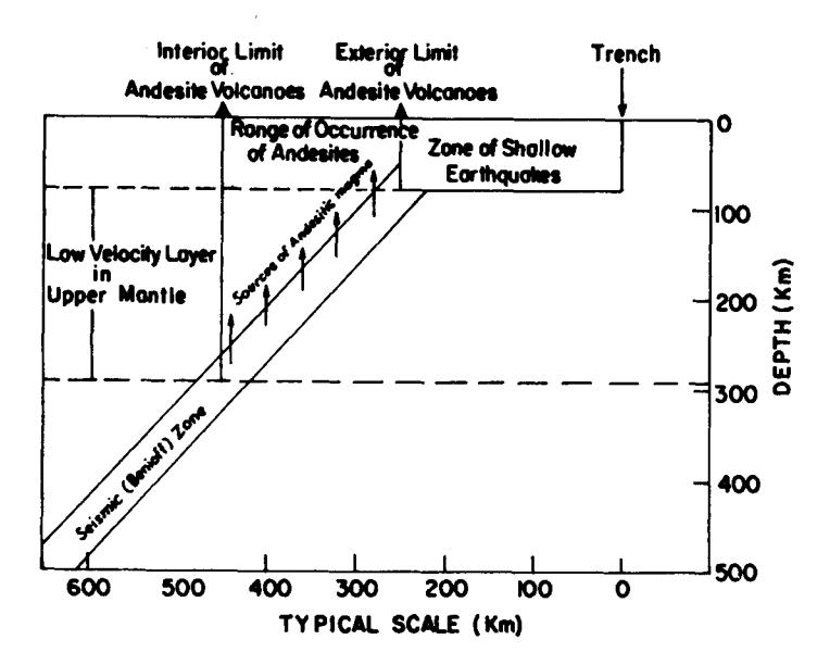
Figure 1. Schematic diagram of model for andesite production and distribution according to Hatherton and Dickenson, 1969.
A more detailed analysis of earthquake focal mechanism shows that shallow earthquakes define a zone of activity bordering the Sulawesi Sea between the northern peninsula of Sulawesi and Mindanao and another zone of activity paralleling the Philipine Trench between Mindanao and the southern tip of Luzon (Fitch, 1970). Between these two zones there is a complicated region, dominated at least in recent years, by intermediate depth activity. There is also a shallow and intermediate depth activity North and West of Halmahera that is consistent with the existence of an arc like structure (Brouwer, 1925).
Figure 2 present a seismic profile across the Sulawesi Sea including the seismicity near Halmahera, showing a seismic zone extending to depths greater than 600 km beneath the Sulawesi Sea and another zone extending only to intermediate depths beneath Halmahera.
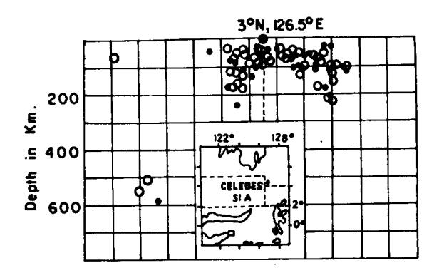
Figure 2. Profile of seismicity beneath the Sulawesi Sea and Halmahera according to Fitch, 1970.
VOLCANIC GEOLOGY OF MINAHASA
General
Minahasa, which is characterized by active volcanoes joints on to the Sangihe volcanic islands in the North. Geologically, part of the Minahasa peninsula, lying NE of the Amurang-Malompar river consists mainly of young volcanics of young Neogene and Quaternary age. Van Bemmelen (1949) mentioned the presence of marine sediments occurring near Kayu Ragi, which are represented by post-tertiary elevated beach deposits and elevated young coral reefs. In the Bantik peninsula, hydrothermally altered diabases and trachytes are reported (Van Bemmelen, 1949) and (Koperberg, 1928).
SW of the line Amurang - Malompar, marine and volcanic rocks of old neogene age are exposed in great abundance. Young volcanics, however, are found to have a much more limited distribution.
Morphologically, Minahasa proper, is divided distinctly into three separate units, namely, into South - Central - and North Minahasa. These three units are separated from each other by the Amurang-Malompar and the Menado-Kema depressions which can be interpreted as transverse fault zones. A third transverse fault runs along the NE coast of Minahasa.
Real active volcanoes, however, are only found in Central and North Minahasa.
Petrology and Petrochemistry of the Minahasa Volcanoes
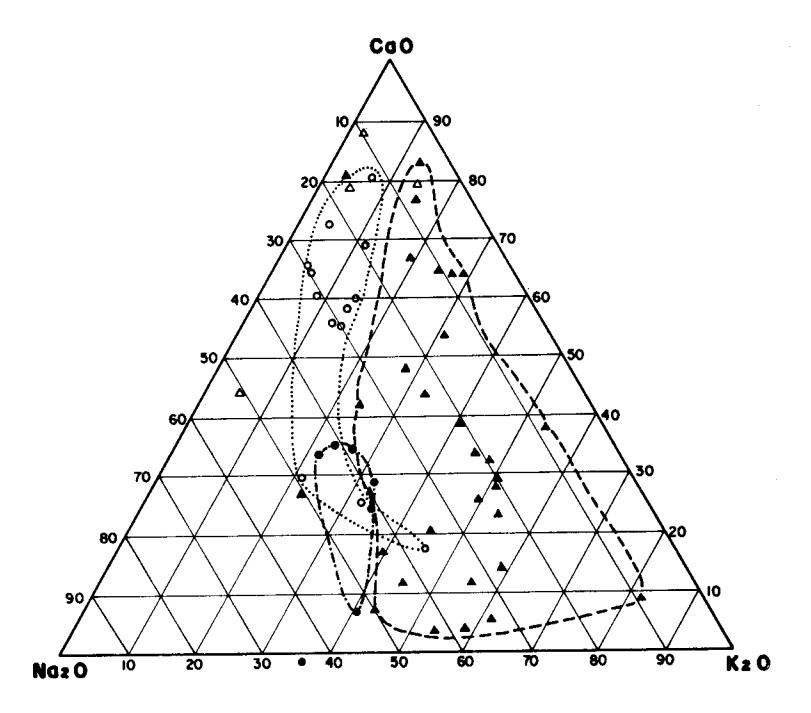
The petrology and chemistry of the rocks produced by the Minahasan volcanoes follow the general plan of a calc-alkali magmatic province usually produced above subduction zones. Table 1 shows the variety of rocks produced by the Minahasan volcanoes. Figure 3 gives a comparison between the various Volcanic provinces of Sulawesi's magmatic arc.
| Table 1. | Rock varieties | produced by | the Minahasan | Volcanoes |
|---|---|---|---|---|
| and surroundings. | ||||
| Rock type | Andesite | Basalt | ||||
|---|---|---|---|---|---|---|
| Pyroxene | Hornblende | Olivine | ** | Trachytes | ||
| 1. | Awu | ж . | ж | x | - | _ |
| 2. | Banua Wuhu | x | x | _ | - | - |
| 3. | Api Siau | x | - | - | - | _ |
| 4. | Ruang | x | - | _ | _ | _ |
| 5. | Tongkoko | × | - | _ | | - | - |
| 6. | Klabat | x | - | x | - | - |
| 7. | Mahawu | x | - | - | x | - |
| 8. | Lokon Empung | x | _ | x | - | - |
| 9. | Laheudong | x | - | _ | - | _ |
| 10. | Tampusu | x | - | - | | - | - |
| 11. | Tempang | ? | ? . | ? | ? | ? |
| 12. | Sempu | , ? | ? | ? | ? | ? |
| 13. | Soputan | x | _ | - | | x | - |
| 14. | Ambang | x | x | - | - | - |
| 15. | Sarongsong | x | - | - | - | | - |
| 16. | Una-Una | x | _ | _ | _ | x |
| 17. | Tanuwantik | - | - | - | - | × |
? No data
Most of the rocks produced by the Minahasan volcanoes are plagioclase-rich andesites with aphanitic groundmasses made of microscopic crystals and glass. Most are porphyritic with visible phenocrysts of plagioclase and pyroxene or hornblende.
According to the New Global Tectonics, andesitic magma are derived from within the slabs of lithosphere descending beneath magmatic arcs (Sykes, 1969). The concept of a heavy eclogite lithosphere that could descend gravitationally along inclined seismic zones is acceptable as an explanation for seismological focal-mechanism solutions, which suggests that down going slabs of lithosphere are locally under extensional stresses in the region of intermediate focal depths above which most andesitic volcanoes are known to stand, like the volcanic province of Minahasa discussed in this paper.
High pressure and high temperature experiments show that partial fussion of dry eclogite can yield melts of andesitic composition in the pressure region corresponding to similar depth of 100-150 km (Green and Ringwood, 1968).
** Just given as basalt
- O Sangihe Minahasa.
- Togian Islands. Maros Province.
- ∆ Talaud.
Figure 3. Diagram showing the position of the Minahasa volcanic rocks compared to the rocks from other magmatic provinces of Sulawesi's West arm and Togian Islands.
Tondano Pyroclastics
The most conspicuous geologic phenomena in Central Minahasa discovered during the short reconnaissance work is the presence of pyroclastic deposits distributed over nearly whole Minahasa.
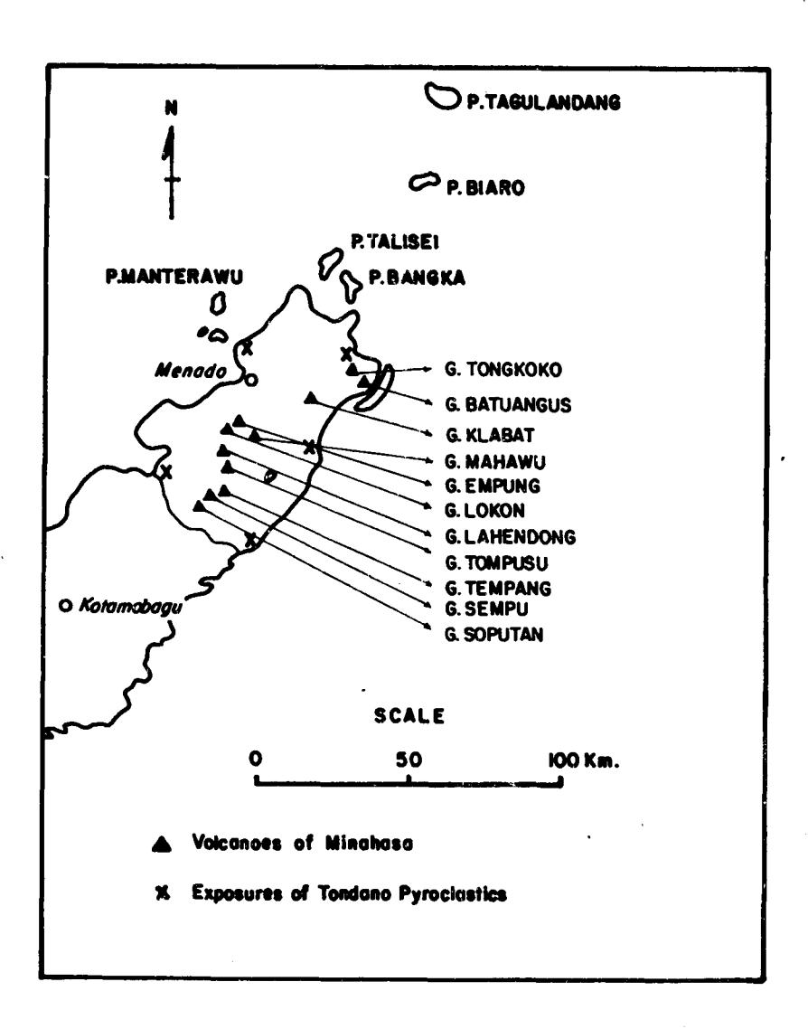
Figure 4. The volcanoes of Minahasa and places with remotest distribution of the Tondano pyroclastics.
Good exposures of these pyroclastics are found along the eastern shore of Lake Tondano, especially in the vicinity of Watumea village, along the road Ratahan-Amurang, from Ratahan down to the South coast, b tween Amurang-Kawangkoan, Tanawang-ko-Sonder, Menado-Kema-Langsot, Kema-Bitung, Menado - Tomohon, along the road between Air Madidi-Tonsea Lama-Tondano and between Menado-Pandu in the North (See Figure 4).
The presence of these pyroclastics in the previously mentioned places proves that they are widely distributed, covering once whole Minahasa. Only the products of younger activities obscure and obliterate most exposures.
From this it can fairly be assumed that these pyroclastics form part of the base of the younger volcanic cones, like Mt. Klabat, Lokon - Empung, Tampusu and the Soputan complex.
The numerous exposures, especially along the road Amurang -Kawangkoan, show that this huge pyroclastics were deposited through several eruption cycles.
At this spot, two uniform masses, each of 4 meter thick lying one upon another are covered by not less than 13 layers of pumice - tuff of about 20 cm thickness. In places where these pyroclastics are exposed pumice fragments are always observed, they range in size from a few mm to blocks measuring 15-to-20 cm across. These pumice fragments are angular to subangularly shaped. However, the farther away from Lake Tondano the fragments lost their angular to subangular shape and change into rounded oblong pumice bombs with distinct flow directions.
Except for some zones of compaction and a very limited zone of welding, generally the Tondano pyroclastics do not show welding phenomena.
Lake Tondano
The beautiful lake of Tondano in the plain of Tondano, lies at about 680 m above sealevel. The Tondano Highland is bounded in the East by the Lembean Ridge. Several wellknown peaks of this ridge are: Mt. Kamington, Mt. Kaweng and Kawatak. In the West the Tondano Highland is bounded by young volcanoes of the Soputan complex, Lengkoan, Tampusu and Tolongkouw, in the North by the volcanoes of Masarang and Rumengan.
The Lake itself is drained by the Menado river which incised a channel between the Masarang complex and the northern extremity of the Lembean Ridge.
The Lake has a maximum length of 12 km and an average width of 4 km. Its maximum depth, between Remboken and Telap, is not more than 28 m. A small inhabited island called Likeri lies close to the eastern shore.
According to Van Bemmelen (1949, p.389), "Lake Tondano resulted by ponding up of the drainage in a longitudinal rift-valley on the crest of the Minahasa geanticline, bordered to the SE by the slightly crescentic Lembean scarp and to the NW by a row of young volcanoes".
Verbeek (1908), the Dutch Governor Robertus Padbrugge (op. cit. Kemmerling, 1925, p.105), as well as Kemmerling (1925) himself hinted that the Lembean ridge which bordered the lake in the East, might be the remnant of an old craterwall of which the western part had collapsed.
Indeed, the Lembean ridge has a peculiar shape. It is slightly crescented, but it certainly does not resemble the remnants of a craterwall. The upper part of the Lembean Ridge consists of rocks which are distinctly older than the covering pyroclastics discussed in this paper.
As far as the lake itself, the authors of this paper do agree with Van Bemmelen (1949) that the lake resulted through ponding the drainage system. A more fundamental question is namely the origin of this morphology itself which made the formation on the lake by ponding possible.
The authors of this paper do not agree with idea of Verbeek (1908), Padbrugge and Kemmerling (1925) that the Lembean ridge is the remnant of an old craterwall. However, the thors do believe that the Lembean ridge is a faultscrap along which the western part of the old Lembean volcanic-mountain collapsed. This event must be connected with the production of the huge pyroclastic deposit mentioned in this paper previously, since none of the smaller young volcanic cones of central Minahasa could be held responsible for such a voluminous production of the rather acid pyroclastics. However, the ejection of this pyroclastics was not connected with a single central eruption, nor was it a type which formed the Toba resurgent cauldron (ZEN, 1973). It is more likely that the ejection of the voluminous mass of the Tondano pyroclastics was related with a fissure-like eruption and that the production of the pyroclastics happened in many eruption cycles during one but rather long period.
The pattern of distribution does indicate that the thickest deposit is found around Lake Tondano and decreased gradually with distance from the lake.
Until more data are accumulated and until all the data recently collected are analyzed, the authors of this paper refrain themselves from drawing definite and long range conclusions.
CONCLUSIONS
- The huge deposits of pumice tuff in Minahasa, referred to by the authors as the Tondano pyroclastics are of the pyroclastic flow sheet type. Field evidence obtained thus far leads to a working hypothesis that they were produced by fissure like eruptions on the crest of the old Lembean Volcanic Mountain now occupied by Lake Tondano.
- These pyroclastics were partly emplaced aerially and partly also by flowage.
- 3. The magnitude of this deposit makes it necessary for these pyroclastics to be mapped as a separate unit and that the regional mapping team of the Geological Survey of Indonesia should pay a considerable attention to its distribution.