

INTRODUCTION
Tertiary sedimentary basins of Indonesia have been known as prolific oil producer. Unfortunately the geology of these basins is little known except in general outlines. Since the work by Van Bemmelen (1949) very little has been published, since relatively little geologic investigations have been conducted. Previously the results of oil companies exploration work could not be published due to the competitive nature of the industry. Publications by Dufour (1957), Phillipi (1957), Wennekers (1958) and Weeda (1958) and also as outlined by Koesoemadinata (1969) on the oil basins of West Indonesia are largely based on pre-World War II data. The voluminous work by Hermes and Vischer (1962) on the results of petroleum exploration in West Irian is one single great contribution on the geology of Indonesia by the industry. A more recent publication on the South Sumatra basinal area has shed more light on the nature of sedimentary basins (Pulunggono, 1969).
The nature of the present day petroleum industry in Indonesia makes it possible to compile the results of petroleum
exploration throughout Indonesia. At present basin studies are being undertaken in many parts of Indonesia. Very significant contribution to the knowledge of the regional geology of Indonesia is the result of offshore exploration which has been conducted extensively in Indonesian waters since 1967. Modern marine geophysical methods and processing techniques followed by fast modern offshore drilling make it possible to obtain geological insight within relatively short period of time. This in turn also contributes much to our understanding of the geology of the onshore basins. Some of the results of offshore exploration in western part of the Java Sea was presented by Todd and Pulunggono (1971) at the American Association of Geologists meeting in Houston, Texas.
This paper will deal with the preliminary results of off-shore exploration in Indonesia. No details can be given, as exploration work is still progressing at an ever increasing speed. Many wells are scheduled to be drilled for many years to come, more detailed seismic work are still being undertaken. This paper is not based on an intensive study, but largely on day to day knowledge as exploration progresses. Evaluation of geologic data and intensive basin studies based on offshore as well as onshore exploration results are being undertaken, and will undoubtedly contribute a great deal to the geology of Indonesia.
MAJOR TECTONIC FRAMEWORK
The Indonesian Archipellago consists of island-arc systems, typical of the western pacific. A discussion on the island-arc nature of Indonesia is given elsewhere in this Congress by our colleague (Katili) and will not be repeated here. This island-arc system enclosed main shallow shelf sea areas, which are also large tectonic - physiographic features; the wellknown Sunda Shelf and the Sahul Shelf (Figure 1). The first belongs to the continent of Asia, and the latter to that of Australia, while in between are oceanic basin deeps. Although both shallow seas are presently the scene of active exploration for oil, much more has been known about the Sunda Shelf, so that this paper will primarily deal with Tertiary basins in the western part of Indonesia.
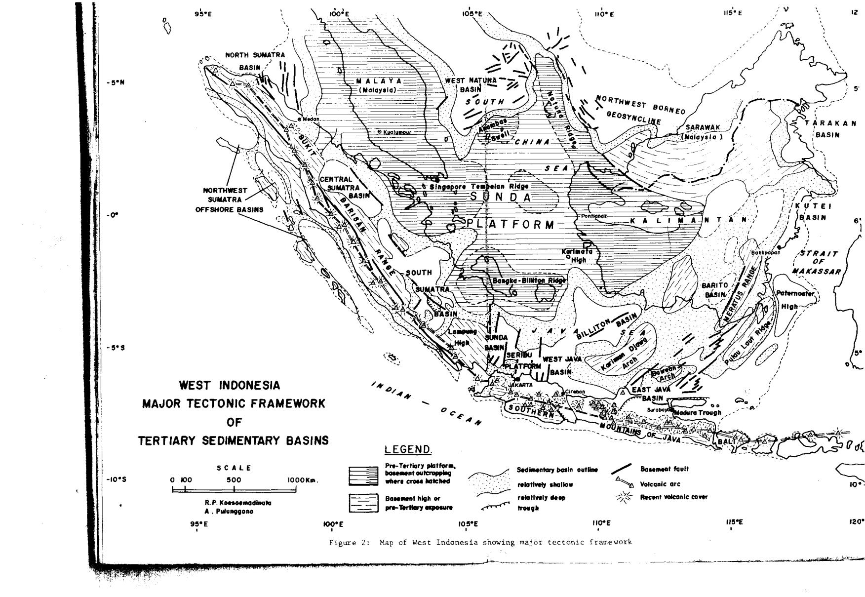
The following major positive tectonic elements may be recognized (Figure 2):
1. The Sunda-Platform (Sunda Shelf ss.); which is formerly thought to cover the entire Java Sea and South China Sea. It is now recognized to extend only between Bangka-Billiton Ridge in the south, and the Anambas and Natuna Ridges in the north. It consists primarily of consolidated pre-Tertiary sediments, which are locally metamorphosed and
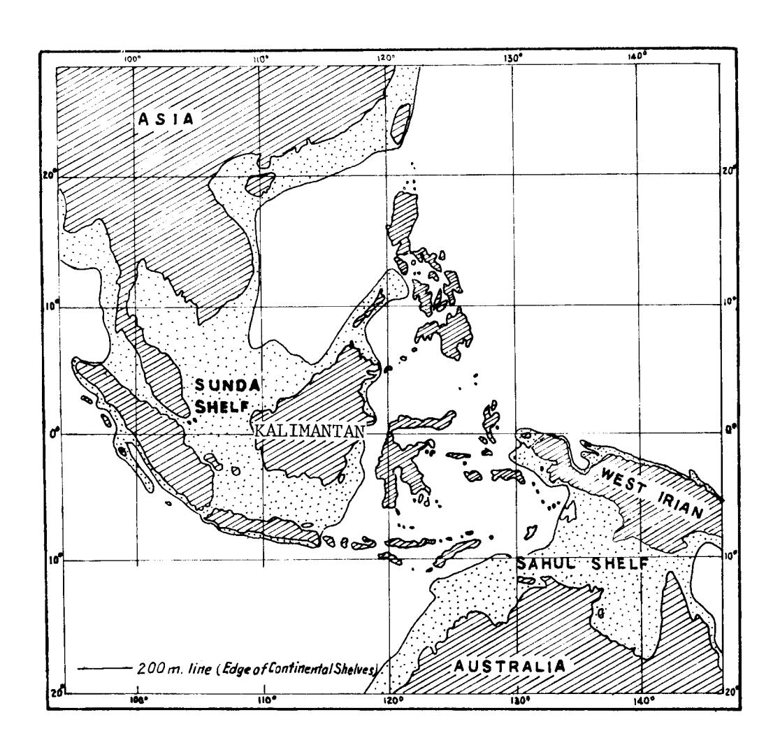
Figure 1: Map of Indonesia showing shelf seas
igneous rocks of various ages. referred to as trbasementtt. In this paper it will be
This stabilized shelf area has been considered as the core of Indonesia, having only a thin cover of rather undisturbed Tertiary sediments. Around this core are the main Tertiary Sedimentary basins.
- 2. The Inner Volcanic Arc; represented by the geanticllnes of Sumatra and Java.
- 3. The Auter non Volcanic Az,c; represents by the islands offshore west Sumatra. South of Java it is represented by a vague submarine ridge. North of the Sunda Shel-f no equivalent island-arc exists, but positive areas are known (Sino-Cambodian Shield) .
In between these main major tecfonics elements are the Tertiary Sedimentary basins, which are prolific in oil. The onshore portj-ons of these basins have been frequently described (van Benunelen, 1949, Weeda, 1958, Wennekers, 1958, and Koesoemadinata, 1969) and has been called "ideo-geosyncllnestt by Umbgrove (1933). The bffshore portlons of these baslnalareas, especially in the Java Sea have shed more llght ln the nature of mechanism of basin formatlon, as more modern selsmic processing techniques have been employed.
Two major offshore Tertlary baslnal areas can be recognizedl the Java Sea basinal area, and the South Chlna Sea basinal areas.
THE WESTER]{ JAVA SEA BASINAI, AREA
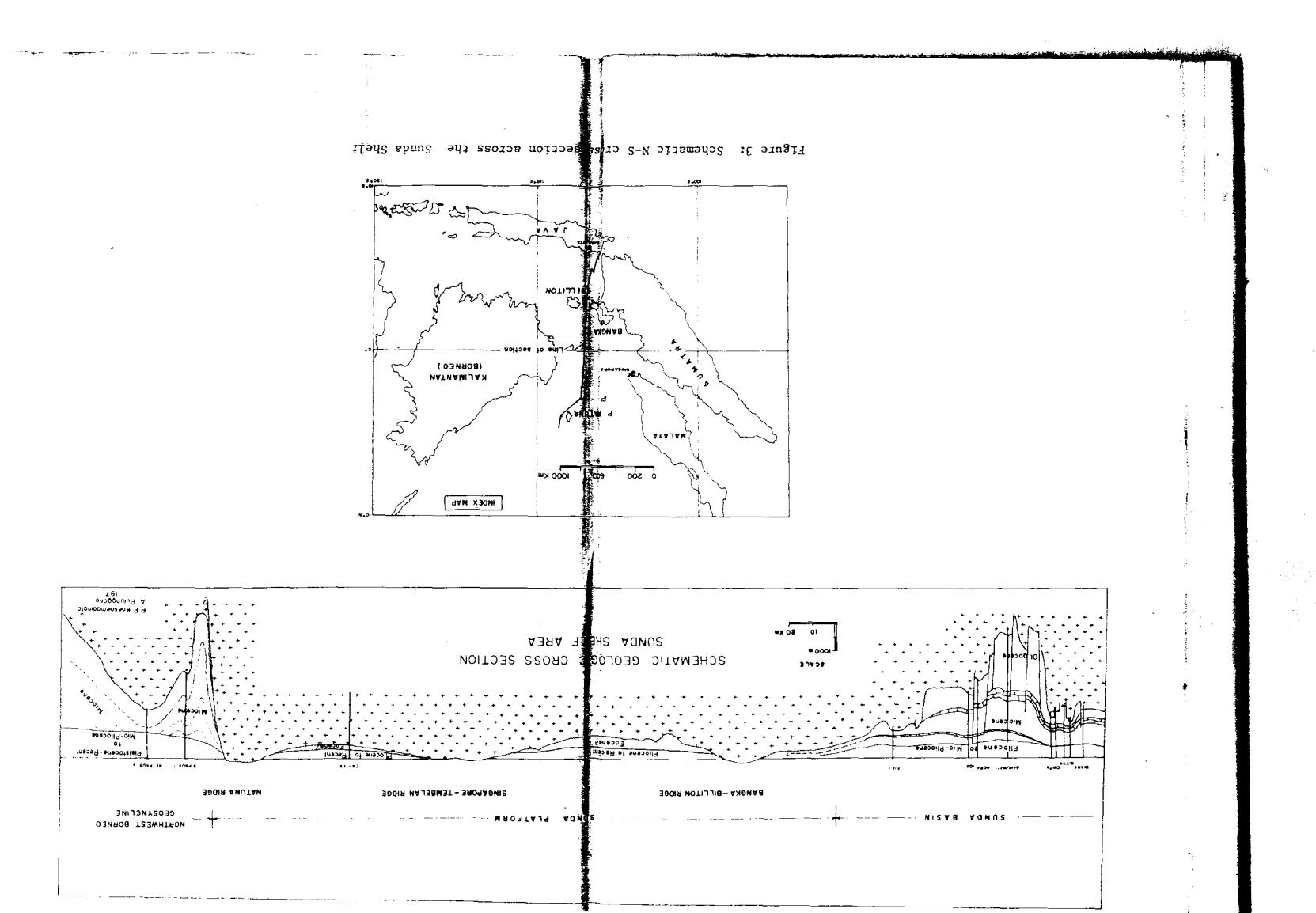
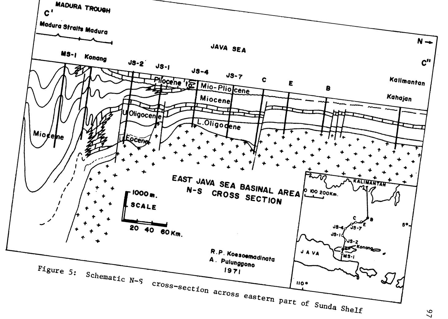
A major NE - SW trending positive tectonlc element separates the LrTestern Java Sea basinal (or the Sunda Baslnal area) frorn the eastern Java Sea basinal area. This tectonic element is called the Karimun Jawa Arch, represented by pre-Tertiary outcrops on Karimun Jawa Island group. This positive element appears to be a high area during the entire Tertlary tlmes, supplying sediments into the adjacent basin (Figures 3 and 5).
Ihe nature of the basins has recently been described by Todd and Pulunggono (1971). The controlling factor effecting tl-re basin formation, appears to be a major block-fault system on the rugged pre - Tertiary basement, which here consists of pre-Tertiary metamorphics and igneous rocks. Block-faulting subdivided the area into the Sunda Basin in the west, and the West Java basin in the east, separated by the Serlbu Platform, while in the northeast a deep is called the Billiton bastn.
In the Sunda and West Java basins a major north - south block-fault system governed erosion, deposition and tectonic growth throughout Terti.ary t.ime. This pre-Tertiary system existed as the most influential tectonic element in forming
the structural grain of these two basin, structural axls are also parallel to the fault system rather than paralle1 to the Java geanticlinal axis.
As a resul-t of continued Tertiary movements along these fault lines in the Sunda and West Java basin, structural growth and density are unusually high. Structures are often large in areal extent. The greatest Tertiary fault movement occurred in Oligocene and early most Miocene time. At least 1300 rqeters of displacement took place durlng this perlod along the east flank of the Sunda basin. Differential movements along many fault zones continued through Middle Miocene. Many structural features of the Sunda and West Java Basins exhibit structural growth during Tertlary deposition resultlng frorn fault movement. The north-south allgnment of the Sumatra coastline suggest a fault zone on the west flank of the Sunda basin adjacent to the Lampung high.
A similar basement block-faulttng tectonic control on sedimentation has also been establlshed in South Sumatra by the author (Pulunggono, 1969). Here the major fault trend is NW-SE, parallel to the Semangko Riftzone which has been established as transcurrent fault rdith recent movements by Katlll and Hehuwat (L967). Cross-trends, presumably fault-control-1ed, is in evidence in early basinal hlstory.
The Billiton baslnal deep also appears to be lnfluenced by a northeast southwest fault zone parallel to the Karlmun Jar"ra Arch. This deep basement fault zone ls expecteil to be present also onshore, extendlng from Jatibarang to Pelabuhan Ratu, called the "Pelabuhan Ratu Trough", where turbldite sedimentation have been observed. Simllarly, a NW-SE trend, parallel to the Sumatra trend is also suspected to lnfluence the NW-SE trending-Cirebon-Banyumas Trough, where again turbldite sequences have been observed. It appears that the Java geanticline is dissected by faultzones, and the southern mountain of West Java appears to be an upllfted block.
THE EASTERN JAVA SEA BASINAL AREA
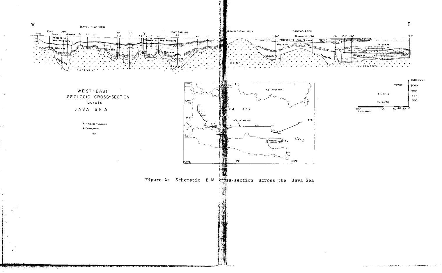
This basinal area is also characterlzed by block-faulting (Figures 4 and 5) . However, the- trend ls strongly IIE-SW, a trend already apparent in the Billiton basln and also exPress: ed by the Karimun Jawa Arch. Other positive areas are the Bawean Arch, and the more less pronounced NE-SW trending Masalembo High. More to the northeast there are several other highs. The basinal deeps are generally rnuch narrower and elongated in the NE-SW direction, as if squeezed in between the broad positive bl-ocks e.g. the basin between Bawean Arch-Karimun Jawa Arch. Indications are that in general the sediments are becoming thicker towards the southeast, i.e. Kangean Island.
Superimposed on this rather old Tertiary basinal configuration is the strong E-W trending Madura Strait Trough, a young Tertiary feature. More than 10.000 feet of Recent to Pliocene sediments is known in the Madura St.rait, contrasted to less than 18.000 of sectlon for the entire Tertiary in the eastern Java Sea area. This trough, the extension of the Randublatung zone in east Java, has a more geosyncllnal nature. Dlapiric structures are known from seismic data. Ihe eastward extension of this deep, is stlll unknown presently. In general the nature of the Tertiary basin toward the Flores Sea is still known to the authors, as exploration rrrork is just ln the beginnlng stage.
In the southern part of Strait of Makassar (offshore Pulau Laut) basement'hlghs also play a domlnatlng role, i.e. the Paternoster High which has about 1000 meters of Tertlary sediments. This high is presumably a pre-Tertiary basement composed of metamorphic and igneous rocks. Parts of thls high have undergone active subareal erosi-on and contrlbuted cl-astics to the adjoining basinal areas. The Paternoster High 1s bounded on the southeast by a down to the NNE-SSW trendlng najor fault or fault zone down stepping toward the southeast. The growth fault nature of bastn is clearly shown by the sedimentary sequence in the section 1 (see Flgure 6).
Northward, Miocene sediment.s are known to reach more than 3500 meters in an offshore welL east of Balikpapan, while offshore of Tarakan there are indlcations of marginal highs separating the shelf sediments from the oceanic deep of the Strait of Makassar.
SOIJ"IH CHINA SEA BASINAL AREA
The geology of this area has been discussed by numerous authors recently (Geiger, 1963, Hail-e, Key and Pimm, L964, Haile, 1968, 1969, L970, Issacrs, 1962. In thls paper, results of recent exploration efforts, especially drilling will briefly be summarized.
Extensive seismic surveys and subsequent drilling has confirmed the general outline of the Sunda Platform in this region. Two mai-n basinal areas can be recognized; the Northwest Borneo Geosyncline in the northeast side, and the west Natuna basin in the northwest. The Northwest Borneo gecsyncline has a strong NNW-SSE structural trend. Seismic map of a horizon below a major unconformity shows NNhI - SSE trending fault pattern whl1e the basement becomes rapidly deeper toward the northeast. Fold axis are more or less aligned para1lel to this fault trend, whil-e di-ssecred by NE - SW normal faults.
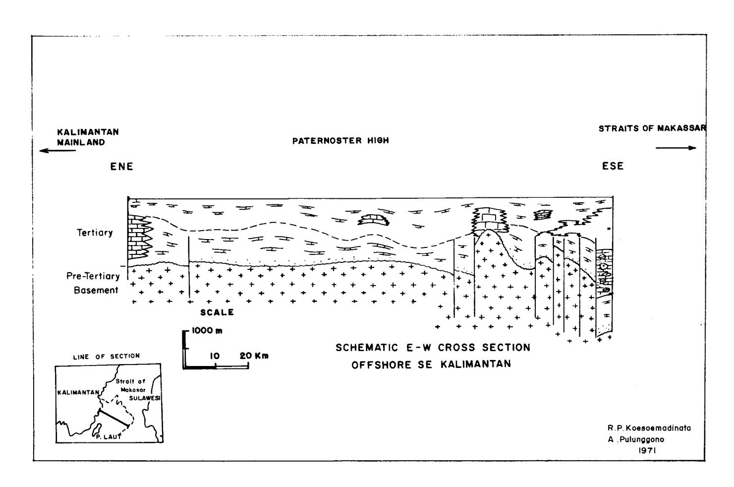
Figure 6: Schematic E-W cross-section across P. Laut, SE Kalimantan
Southwestward onlapping of Late Tertiary sediments toward the platform has been recognized.
This basln apparently controlled by a rnajor fau1t, hinges on the Natuna Ridge. Basement of the Northwest Borneo Geosyncline consj.sts of low grade metamorphic rock, such as phylJ-ites of Cretaceous-Eocene age. In the platform area the equivalent of thie unit J"s represented by ttthe Plateau Sandstoneil largely urunetamorphosed, although separated by a major unconformity from overlying Tertiary Sediments.
In the hrest Natuna basin a sl-milar set up has been recognized. The fold-trend along this basinal edge is definitely NE - SW, parallel to the predominating fault trend. NW-SE trending faults are also present. A major fault as shown in Northwest Borneo ge.osyncline is not present, but step faulting is well expressed. The folds are tlghtly controlled between these faults. The zone of folding is ln between trilo major synclines. Within thls zone diapirlc (apparently shale) intrusions are present parallel the above mentioned trend. This NE - SW trend seems to abut toward the Malayan pre-Tertiary trend. Younger Tertiary sediment are onlapping the Sunda platform.
A prominent feature of this northern part of this Sunda Shelf is the socalled Natuna Ridge, which trends NNW - SSE toward Vietnam. trIithin thls arch, faulting ls also knor^rn paral-1el to the trend. In the northwesternly extension of this ridge, the NNW - SSE and NE - SW trends are intersecting each other.
NORTHWEST AND NORTHEAST SUMATM OFFSHORX AREAS
Other offshore Tertiary basins are those situated between the inner volcanic arc and outer non-volcanic arc, off Sumatrars west coast. Recenf seismic surveys followed by drilling confirmed the presence of sma11 Tertiary basins, with Eocene sediments at the base. The outli-ne of the basin very much parall-el the Sumatra trend, but are subdivided transversely by intervening highs.
The Northeast Sumatra basi-n is known to continue offshore. It appears that no rnajor fault is to be found as suggested by Weeks, Harbison and Peters (L967) who postulated a NE-SW trending fault on the basis of a submarine topographic feature. The basin opens up toward the NW.
In general it can be said that NW-SW trending faults are common in Sumatra basinal area. These faults are very important in the formation of the basin. In South Sumatra basin such a fault has been described to border a basinal deep (Lematang basin) from a high area (Talang Akar - Pendopo - Limau Ilj-gh) (Pulunggono, 1969). In central Sumatra basin such a NW-
SE trending fault separates the Tapanull Basin from the Rokan Uplift. In north Sumatra basin such a similar trending fault with a pronounced strike - slip movement has also been recognized.
TERTIARY SEDIMENTATION
Tertiary sedimentation did not begin simultaneously throughout the basins, although the sedlmentary sequences are similar. This has been observed by the author in onshore basi-ns (Koesoemadinata, L969), that Tertiary sedlmentatlon consists of one megacycle, starting with transgresslon and endlng with a regression. Deviation from this sequence is apparent in the Java Sea basinal area, especially toward the east. In the West Natuna basin and the offshore portion of the Northwest Borneo geosyncline, a regressLve phase did not take place at the end of cycle.
In the West Java baslnal area Eocene transgresslon took place from the south, but did not reach the offshore baslnal areas. Eocene occurrences are restricted to southern part Java. In the East Java Sea Basinal area, however, Eocene also transgressed from the south, east and northeast. In East Kalimantan Eocene sedlnentatlon is firmly establlshed. The transgressive character of Eocene sedl,ments are frequently preceeded by parallc sedlmentation or even non-marine fluviatile sedimentatlon. Eocene transgression is also establlshed in the northwest Suroatra offshore baslns as wel-l as northeast Sumatra baslnal area. Apparently most of the Sunda shelf area was undergolng subaerl,al erosion, resulting into rugged topography. Block-faultlng may also have been responsible for this topography.
In West Java basln, Eocene is represented by volcanlc products, generally restricted to the southern part of Java, but extend also lnto the Java Sea (i.e. Jatlbarang area).
On the Sunda Platform and also in the northern basinal areas, the Eocene marked the end of a Mesozoic sedlmentation cycle, characterlzed by the deposition of i nolasse type nonmarine sediments, the ttPlateau Sandstonett or the trNatuna Formation'r as proposed by Haile (1970).
In the Northwest Borneo geosyncline Cretaceous - Eocene sedi-ments were folded and metamorphosed at the end of Eocene, and subsequently eroded. Here actual Tertiary sedimentation started in Miocene Time.
Blockfaulting control of sedlmentation is well exhiblted by the offshore basin of Southeast Kalimantan. Thick conglomeratic sediments including limestone, were deposited during the Eocene in the dovmthrown side (Figure 6).
During Oligocene time clastic sedimentation ln topographic lows marked the beginning of the Tertiary cycle in the Sunda basi-nal area. Main sources of these clastics are from the Bangka-Billiton high at the edge of the Sunda Platform a-nd Kari-mun Jawa Arch and the Lampung high. Blockfaulting continued to be the control-Ling factor in basin sedimentatlon, Rapid subsidence-kept pace with clastic infillings of the fault controlled basement lows, resulting into coarse clastics from the adjacent localized fault block.
In the beginning sedimentatj-on took place under non-marj-ne or at least paralic' conditions, such as deltaic, paludal or even fluviatile environments. As marine invasion from the south continued northward, marine condition prevailed, while several basement highs continued sticking above sea1eve1, supplying secondary clastic sediments, while the main source remained the Sunda-land in the north.
In eastern Java Sea basinal area this depositional condition has not been established, but there indications that similar happenings took place. More toward the east, northeast and presumably also to the south sedimentation started almost iuunediately under marine condition, followed by carbonate deposition. As trangression progressed westward 1ocal highs vere still sticking above sea leve1, e.g. Bawean Arch. Basement-fault control of sedimentation is less obvious here. Carbonate deposition is very conspicuous in this basinal area. During Lower Miocene time most basement highs in the entl-re Java Sea were practically submerged, with the exception of a few highs, such as the Lampung tlj-gn and Karimun Jawa Arch. This period was marked by an extensive carbonate deposition, including coralli-ne reefs; the latter especially directly on top of the submerqed basement highs. This extensive limestone formation can be followed from the Sunda basin to the easterlunost part of the Java Sea. It is equivalent to the Berai formation in the SoutheasE Kalimantan basin, and the Baturaja limestone of South Sumatra. It was presumably during this time that an eastwest trending trough was formed occupying the present Madura-Rembang zorLe of van Bemmelen (1949). Thick limestone reefs marked the edge of this downwarP.
Marine sedimentation constitued in the whole Java Sea basinal area, wh11e in the basinal deeps shales were deposited. In the \^restern Java Sea basinal areas (Sunda Basinal area) sediment lnfilling had gradually changed the floor to a relatively flat plane devoid of deep trough and steep basement highs. The maximum transgression, covered also the Lampung High and presumably also the Karirnun Jawa Arch. Thj.s infilling, associated with uplift to the borderland, caused the sea to reverse into a regressive phase with secondary transgrbssive incursions.
In the eastern Java Sea basinal area a similar sedimentary succession took p1ace, with the exception that more carbonates were deposited, especially in the southern and eastern portions. Lack of clastic sources is presumably responsible for this type of sedimentation. Less carbonate sedimentation occurred after the extensive Lower Miocene limestone deposition. Detrital clastics r^7ere even deposited frorn high areas, such as the Karimun Jawa Arch. However, at this time only very few basement highs remained above sea level. Isolated reefs occurred along the presen! northern coastal line of Madura.
The regressive phase in Upper Mid - Miocene is more pronounced here being represented by folding and uplift, til-ting the whole region gently toward the south, followed by erosion (Figure 4). In the East Java - Madura area the E-W trending trough shifted toward the present Strait of Madura (Randublatung zone of van Bemmelen, L949). This orogenic phase is not everywhere represented by folding, uplift and emergence. In the v/estern part of East Java basinal area (Cepu area) this phase is represented by a regression and deposition of detrital clastics (Ngrayong sand), followed by a second transgression. In the Madura Strait Trough (including Randublatung zone) downwarping continued, resulting into thick deposition.
The second transgression during Mio-Pliocene time is more pronounced in the eastern Java Sea area. The southrvard tilted pre-Upper Miocene strata j-s truncated and covered by reclfal deposit, which is rather extensively distributed (Figure 4). The area apparently became a shallow shelf.
In the southeast Kalimantan offshore area (Pulau Laut) the depositional sequence is similar to that of the eastern portion of the eastern Java Sea area, where carbonate deposition predomj-nated (Figure 6) .'1t'.'',,,.
The eastern Kalimantan offshore area has a similar depositional history as onshore (Mahakam Basin). Toward the end of Tertiary thick deposition of detrital clastics took place in a typical regressive phase. The pre-Tertiary basement has not been reached here.
The offshore portion of the northeast Sumatra basin shows similar depositl-on sequences as of offshore portion. The basement-fault, however, appears to have controlled deposition a1so.
Sedimentation history of the offshore basin west of Sumatra appears to be similar. The sequence begin in Eocene time, as is known from the outcrop sections in the neighbouring island. Numerous unconformities have been found, the 01igocene especially is missing. Environments of depositlon are generally shallow marine, and Tertiary reefs have been encountered. Although volcanic material forms a considerable part of the clastics, no characteristics of eugeosynclinal nature has been recognized.
In the West l{atuna basin, sedimentation sequence is different. The beginning of Tertiary sedirnentation j-s not known, as indeterminate (non - Marine) sediments from the base of sequence. Palynological analyses suggest an Oligocene age. It is not until Upper Miocene that marine sediments have been identlfied. NE-SW trending step-faulting with the down thrown side on the NW appears to influence sedimentation (growth fault). Shale diapiric intensions are apparently associaLed with these phenomena.
In the Northwest Borneo basin (geosyncline), the pronounced NNW - SSE trending fault is influential for sedimentation. The Tertiary cycle of sedimentation began in Lower Miocene time. Phyllite forms the basement which has been determined by K-Ar age as Oligocene age, Sedimentation started in shallow marine envl-ronment but immediatelly followed by deep to moderately deep marine condi-ti-on, until Quarternary. However, limestones i-ntercalations are also known in the se-9uence.
In this area folding took pJ-ace in Pliopleistocene time. Folding is presr:mably entirely due to basement faulting, as starta occurring away from faults are flat lying. Pleistocene occurs unconformably on top of folded Pliocene to Miocene sediments.
EAST INDONESIA
Not much i"s at present knovm, as data are sEill being collected, and being studied. Marine geophysical surveys and drilling are in progress. Numerous offshore drilling locations are scheduled for several years to come.
Ilowever,'recent seismic surveys fol-lowed by drilling confirrned the extension of the Salawati and Bintuni basins: s€Parated from each other by the Ayamaru Platform (Vischer and Hermes, L962). Fault - control of basin mechanism is convincing. The Sorong fault-zone-swing toward SW near Salawati island, becoming a major dipslip fault, bordering the Salawati basin on the NW (see Figure 7).
Pre-Tertiary sedimentary basins are aslo indicated NW of the Arafura plaEform (Sahul Shelf).
CONCLUSION
Recent extensive marine seismic investigatlons and subsequent drilling have contributed considerably to the geology of Indonesia. They have considerably changed our concepts of geotectonics and sedinentation history of the region as well as on basin mechanism.
Basement block faulting appears to have broken up the Sunda Shelf, which was consolidated toward the end of Mesozoj_c ti.me. Three sets of rnajor fault directions appear to dissect the pre-Tertiary landmass, NW-SE in western part (particularl-y in Sumatra) and the northeast edge of Sunda Shelf, a NE-SW particularly in eastern Java Sea and east Kalimantan (and t{W edge of Sunda Shelf as well as NW Borneo), and a N-S set, especially developed in West Java Sea basinal area (Sunda and West Java babins).
I t I
The first two sets may have originated as strike - slip faults, but considerable differential vertical movements must also have taken place, resuJ-ting into several basinal- subsidence and intervening highs. The N - S trending faults of the Sunda basinal area shows dlfferential vertical movement in a "piano-keyboard" fashion.
An E-W trending fault set is also present, but particularly well developed ls East Java, responsible for the troughlike subsidence of the Randublatung-Madura Straj.t zone.
This fault system apparently left a stable pJ-atform untouched, the Sunda platforrn (or Sunda Shelf proper), which during the enti-re Tertiary tlmes remains stable and provide clastics sediments. However, Kptlli (L967) recognized the present system with the same dlrection as mentioned above.
Fault movements appear to be contLnuous from the beginni.ng of the basinal subsi.dence, and controlled strongly sedimentation (growth-faults). Less differentlal movements took place in younger 'Tertiary, as the sedimentary strata of this age are generally not cut through, but folding 1s apparently localized by these fault trends. Uplifted fault-blocks localized clast.ic sedimentation, whlle carbonate deposition took place away from basement highs. While less is known from the northern part of Sunda Shelf, faultlng apparently also plays a role in sedj-mentation history as well as folding.
REEERENCES
- Bernmelen, R.W. van, 1949, The geology of Indonesia; The Hague, Martinus Nljhoff, v. I and II (2nd ed. l-970).
- Geiger, M.E., 1963, Paleogeography of the late Cretaceous-Eocene geosyncline: Borneo Reg. Malaysia Geol. Survey. Ann. Rept., 1963, p. L79-L87.
- Haile, N.S., Key, A.J. and Plnur, A,.C,, L964, Prelirnlnary report on the oceanographlc crulse of H.M.S. Dampier in the South China Sea, 1963: Brit. Borneo Geol-. Surv. Ann. Rept., L963, p. 11-9-145.
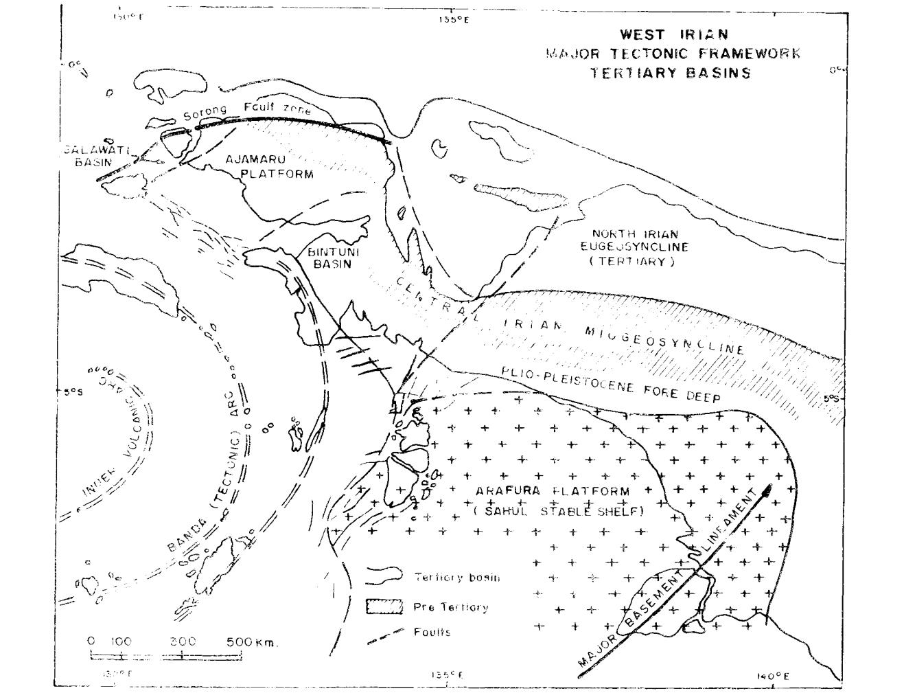
Figure 7: Major Tectonic Frame-work, Sahul Shelf-Irjan
- i{ai1e, N.S., 196B, The northeast Borneo geosyncline in its geotectonic setting: 8u11., n. 1, Geo1. Soc. Malaysia, p. 59.
- Ha1-le, N.S., 1970, Notes on the geology of the Tambelan Annamras and ^ Bunguran (Natuna) islands, Sunda Shelf, Indonesia: Techn. 8u11., v. 3, Econ. Comm. for Asia the Far East ECAFB.
- Isaacs, K.N., 1962, Interpretation of geophysical- profiles between Singapore and Labuan: Brj.t. Borneo Geol. Survey Ann. Rept., L962, p. 3744,
- Katili, J.A,, L967, Structure and age of the Indonesian tinbelt with special referance to Bangka: Tectonophysics, v. 4 (4-6), p. 403-418.
- Katill, J.A., 1969, Recent advance in knowledge of the basic geology of the Sunda Shelf area: Rept. of 6th section, C.C.O.P. (ECAFE), May, 1969.
- Katili, J.A., and Hehuwat, F., L967, On the occurrence of large transcurrent faults in Sumatra, Indonesia: Journal of Geoscience, Osaka City University, Vol. 10, Art. 1-1, p. 5-17.
- Koesoemadinata, R.P., 1969, Outline of the geologic occurrence of oil in Tertiary basins of West Indonesia: Am. Assoc. Petroleum Geologists Bull., v. 53, n. 11, p. 2368- 237 6 .
- Liechti, P., Roe, F.W., and Hail-e, N.S., 1960, The geology of Serawak, Brunei and the western part of North Borneo: Brit. Borneo Geo1. Survey, Bull., 3, 360 p., 2 vol.
- Mainguy, M., 1968, Regional geology and prospects for mj"neral resources on the northern part of the Sunda Shelf; Technical Bul-l. , v. 1. ECAFE .
- Pulunggono, A., l-969, Basement configuration in the south Palembang basinal area; its significance to depositional conditions and oil trappingr Fourth Petroleum Symposiurn Canberra, Australia, Oct./Nov. 1969.
- Schamb, H.P. and Jacksotr, A., 1958, The north western oil basin of Borneo in Habitat of oil-: Arn. Assoc. Petroleum Geologists Symposium TuJ-sa, Oklahoma, p. 1330-1336.
- Todd, D.F. and Pulunggono, A., 1971, The Sunda basinal area, an i-mportant new oil provinee: a paper presented at the Am. Assoc. Petroleum Geologists meeting in Houston, Texas. Considered version: 0i1 & Gas Journ., June L4, I97L, p. 104-110.
- Umbgrove, J.H.F., 1933, Verschillende typen van Tertiary geo-
- synklinalen in Indischen Archipel: Leidsch. Geol. Nededee1., v. I., p. 33-43.
- Weeda, J., 1958, 0i1 basin of East Borneo in Habitat of oi1: Am. Assoc. Petroleum Geologists Symposilm, Tulsa, Oklahoma, p. L137-I347.
- l'/eeda, J., 1958, Oi1 basin of East Java in Habitat of oil: Arn. Assoc. Petroleum Geologists Symposium, Tulsa, Oklahona, p. 1359-1-365.
- Weeks, L.A., Harbison, R.N., and Peter, G., 1967, Island arc system in Andaman Sea: Am. Assoc. Petroleum Geologists 8ul1., v. 51, n. 9, p. l-803-1915.
- Wennekers, J.H.L., 195B, South Sumatra basinal area ln Habitat of Oil: Am. Assoc. Petroleum Geologists SymposlG, Tu1sa, Oklahorna, p. 1347.
(Receiued tsth npriL. 1g74)