
1 0BIntroduction
Plio-Pleistocene strata are well exposed along the uplifted Bobotsari Low/ Basin, particularly south of Mount Slamet in the area around Bobotsari, near Purwokerto City, Central Java (Figure 1 and 2). Here, sediments of at least 50 m thickness accumulated in inner-shelf to subaerial settings known as the Bantardawa-Talanggudang Formation (Suyanto and Roskamil [1]).
The present study deals with the fossil mollusk association derived from the Plio-Pleistocene Bantardawa-Talanggudang Formation, with respect to slow subsidence of the Bobotsari Low in the late Neogene. The Bobotsari Low was subjected to continuous compression contemporary with rapid sediment in-fill during the late Neogene (Lunt, et al. [2] and Cipi, et al. [3]).
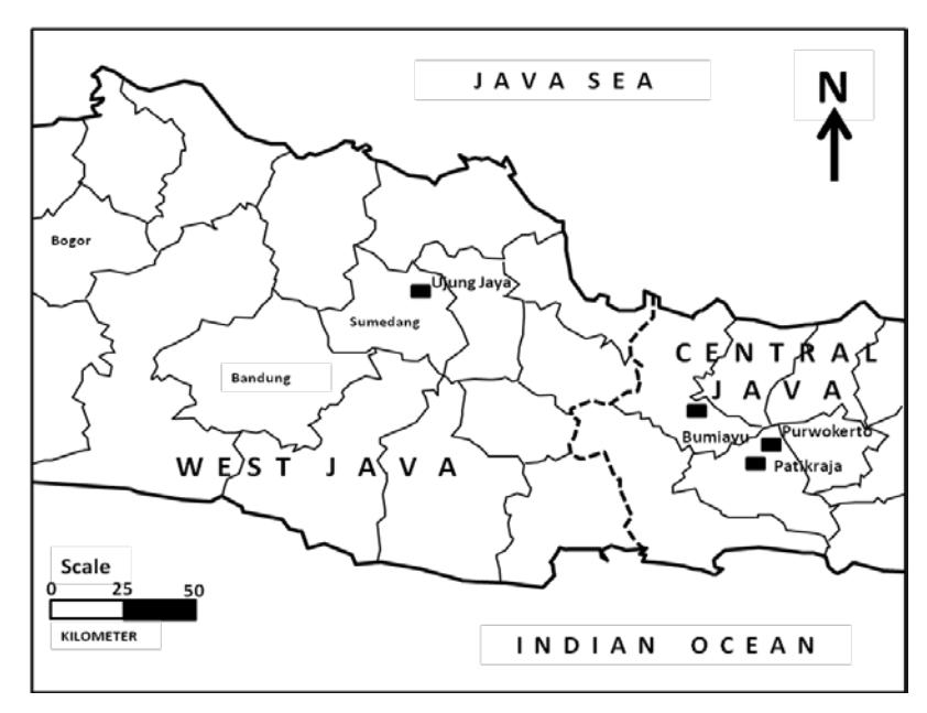
Figure 1 Map of West Java and Central Java Provinces. Locality names used in the text are marked with square signs.
Figure 2 Bobotsari Basin (indicated by white arrow) and the adjacent basins of North Serayu and Bogor (based on Cipi, et al. [3]).
The study of the Plio-Pleistocene mollusk association reveals that the slow subsidence of the Bobotsari Low continued until the early Quaternary, whereas previous studies usually concluded that compression in the study area ceased in the early Pliocene (Lunt, et al. [2] and Cipi, et al. [3]).
This paper also discusses the implications of the results to the petroleum system with respect to slow subsidence as observed during the Neogene and the early Quaternary. In this study, Plio-Pleistocene mollusk fossils were compared with other mollusk paleontological analyses from adjacent basins in the same Plio-Pleistocene interval. The adjacent basins include the North Serayu Basin in the northwest and the Bogor Basin to the west of the North Serayu Basin (Figure 2).
2 Regional Setting
The Bobotsari Low/Basin is an elongated structure extending from the south to the south-east of Mount Slamet in Central Java (Figure 2). The area was shaped by compression and uplift in the Mio-Pliocene as a part of the Majalengka-Banyumas structural high, where the basin formed due to isostatically low areas related to the structural high flank (Cipi, et al. [3]).
Based on the geological map of Purwokerto-Tegal published by the Indonesian Geological Survey Institute (Djuri, et al. [4]), the basin is in general composed of early-Neogene deep marine sediments (lower bathyal to abyssal zones) and late-Neogene shallow marine sediments (tidal to shallow shelf). Early Neogene deep marine sediments consist of turbidite deposits such as the Halang and Kumbang formations. The Halang Formation in general is an intercalation between tufaceous sandstone and claystone, whereas the Kumbang Formation is usually dominated by breccia. Late-Neogene shallow marine rock units are represented by the Tapak and Kalibiuk formations (Kabul, et al. [5], Kurniawan, et al. [6], Aziz, et al. [7], Hanif, et al. [8]), also referred to as the Bantardawa-Talanggudang Formation by (Suyanto and Roskamil [1]) based on the similar lithologic characteristics of the formations observed in the field. The Tapak Formation is dominated by greenish grey sandstone containing a few molluscs and trace fossils, whereas the Kalibiuk Formation is characterized by greenish claystone containing abundant mollusk fossils. The present paleontological study of mollusks was based on fossils derived from the Bantardawa-Talanggudang Formation (after Suyanto and Roskamil [1]). Nomenclature of the adjacent basins as noted in the result was based on Djuri [9] for the Bogor Basin and on Kastowo and Suwarna [10] for the North Serayu Basin.
Based on tectonic activity around the border of West and Central Java since the end of the Miocene, two major strike-slip faults have controlled the configuration of the surrounding basin. These faults are known as the Muria-Kebumen sinistral fault zone and the Pamanukan-Cilacap dextral fault zone (Satyana [11-13]). The surrounding basins include the western part of the North Serayu Basin and the eastern part of the Bogor Basin. These basins are sequentially located in the north and northwest of the Bobotsari Low (Figure 2). The late-Neogene (late-Pliocene) deposit of these basins, which contains mollusk fossils, was also studied as a comparison.
3 Methods
This research paid particular attention to the mollusk fossils in three Plio-Pleistocene stratigraphic sections from the Bobotsari Low, the North Serayu Basin, and the eastern part of the Bogor Basin (Figure 2). Stratigraphic sections representing each basin have been constructed during field work to understand the late-Neogene stratigraphic evolution of each basin (Figures 3-5). In each molluscan bed, whole individuals were identified and counted and their mode of occurrence was examined in a rectangular block, 1 m long parallel to the strike and 0.3 m wide, collected at 30 cm intervals. When only a few individual mollusks occurred in a block, supplementary fossils were sampled from the sediment next to the block. Age determination and reconstruction of the paleodepositional environment were based on foraminifers and mollusks (Oostingh [14]). Foraminifera determination was based on Bolli and Saunders [15], while age determination was based on Blow Zonation (Blow [16]), and paleodepositional environmental interpretations were based on Okutani [17] and Aswan and Ozawa [18]. Mollusk fossil determination followed Beu [19], Martin [20] and Okutani [17]. The term "mollusk association" as marked in the stratigraphic sections is used here to indicate an assemblage of species that occupy a similar habitat. Mollusk fossils collected during field work are now stored in Unggul Prasetyo's private collection and in the collection of the Geological Museum Bandung.
Plio-Pleistocene uplift times were compared among the study basins and the resulting implications for petroleum systems in each basin are discussed in this paper. Seismic and well analyses were also used in developing support for the hypothesis of late-Neogene Bobotsari Low configuration. Furthermore, some previous geochemical analyses of several wells or outcrops from each basin (Muchsin, et al. [21], Noeradi, et al. [22] and Usman, et al. [23]) are also discussed, especially those concerning basin configuration in the late Neogene and their hydrocarbon potential. Geochemical analyses utilized a LECO Carbon Analyzer for TOC determination, and pyrolisis was used to determine Tmax parameters.
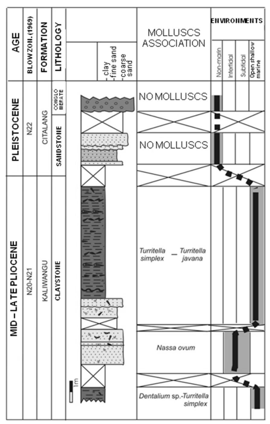
Figure 3 Cibayawak stratigraphic section representing Plio-Pleistocene sediments of the Bogor Basin.
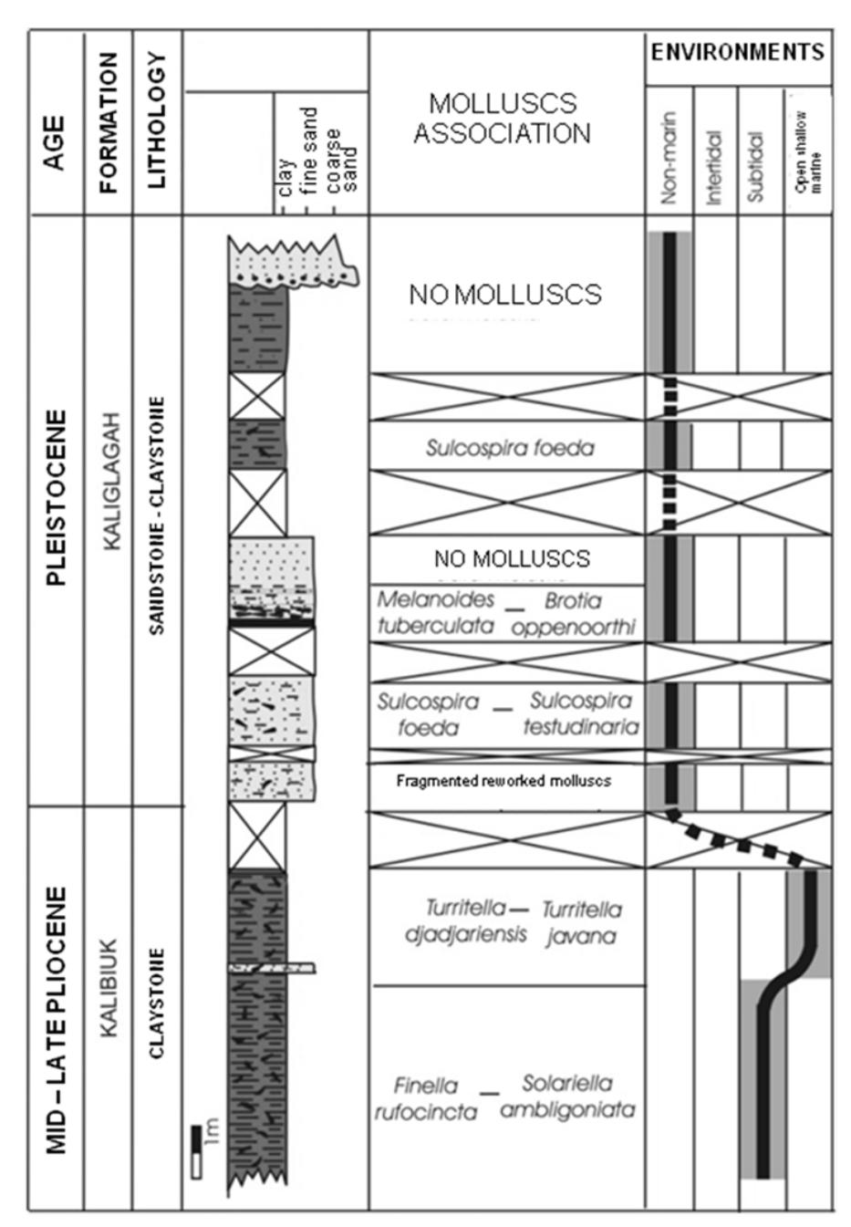
Figure 4 Kaliglagah stratigraphic section representing the Plio-Pleistocene sediments of the North Serayu Basin.
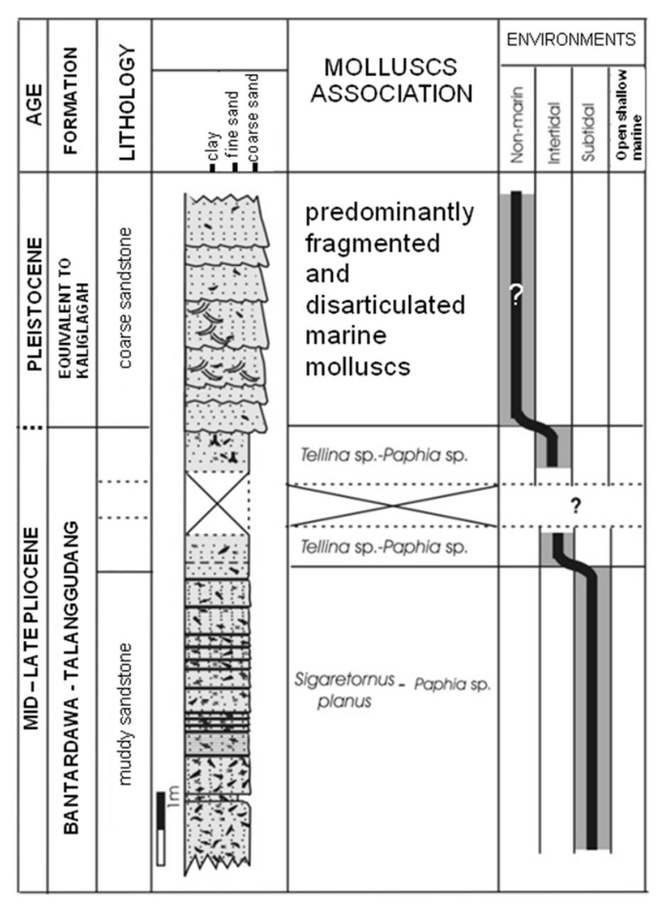
Figure 5 Kedungrandu-Gunung Tugel stratigraphic section representing Plio-Pleistocene sediments of the Bobotsari Low.
Results
Three mollusk fossil locations were studied, one each in the western part of Bogor Basin, the eastern part of North Serayu Basin and the Bobotsari Low. Representative mollusk fossils found during stratigraphic section measuring in the field are shown in Figures 6-11, while taxonomic identifications of mollusk fossils are listed in the Table 1. Stratigraphic columns of these mollusk locations were developed and analyzed with regards to the interpretation of the paleo environment.
Table 1 Mollusk Taxonomic Identification (see Figures 6-11).
| No | Mollusk | No | Mollusk | ||
|---|---|---|---|---|---|
| 1 | a b | Crucibulum extinctorium | 38 | a b | Arca navicularis |
| 2 | a b | Cardium sp. | 39 | a b | Ostrea chlamydoides |
| 3 | a b | Cardium njalindungense | 40 | a b | Anomia sp. |
| 4 | a b | Finella rufocincta | 41 | a b | Arca sp. |
| 5 | a b | Nassarius sp. | 42 | a b | Ostrea sp. |
| 6 | a b | Oliva sp. | 43 | a b | Venus chlorotica |
| 7 | a b c | Sigaretornus planus | 44 | a b | Natica sp. |
| 8 | a b | Eulima sp. | 45 | a b c | Architectonica perspecticum |
| 9 | a b | Dentalium longitrorsum | 46 | a b | Natica aurantia |
| 10 | a b | Dentalium sp. | 47 | a b | Paphia sp. |
| 11 | a b | Dentalium tegalense | 48 | a b | Conus ornatissimus |
| 12 | a b | Corbula sp. | 49 | a b | Strombus isabella |
| 13 | a b c | Solariella ambligoniata | 50 | a b | Natica globosa |
| 14 | a b | Dosinia sp. | 51 | a b | Cymbiola scapha |
| 15 | a b | Tellina bippopoidea | 52 | a b | Dipsaccus gracilis |
| 16 | a b | Ringicula arctata | 53 | a b | Oliva subulata |
| 17 | a b | Turbo sp. | 54 | a b | Pecten sp. |
| 18 | a b | Tellina sp. | 55 | a b | Turritella javana |
| 19 | a b | Nucula sp. | 56 | a b | Bufonaria rana |
| 20 | a b | Cerithium djampangtengahense | 57 | a b | Turritella simplex |
| 21 | Vermetus sp. | 58 | a b | Turritella djadjariensis | |
| 22 | a b | Rapa rapa | 59 | a b | Turritella acuticarinata |
| 23 | a b | Pleurotoma tjibalungensis | 60 | a b | Melania sp. |
| 24 | a b c | Eumargarita angsanana | 61 | a b | Melanoides fennemai |
| 25 | a b | Nassa madiunensis | 62 | a b | Sulcospira testudinaria |
| 26 | a b | Nassa ovum | 63 | a b | Melanoides junghuhni |
| 27 | a b | Natica lineata | 64 | a b | Sulcospira foeda |
| 28 | a b | Arca tjidamarensis | 65 | a b | Murex djadjariensis |
| 29 | a b | Marginella sp. | 66 | a b | Murex sp. |
| 30 | a b | Melanoides tuberculata | 67 | a b | Turritella sp. |
| 31 | a b | Corbula tjiguhanensis | 68 | a b | Viviparus javanicus |
| 32 | a b | Melania soloensis | 69 | a b | Cerithium karangense |
| 33 | a b | Nassarius crematus | 70 | a b | Oliva rufula |
| 34 | a b | Brotia oppenorthi | 71 | a b | Siphonalia paradoxica |
| 35 | a b | Thiara sp. | 72 | a b | Fusus verbeeki |
| 36 | a b | Myurella sp. | 73 | a b | Trigonostoma crispatum |
| 37 | a b | Arca terhaari |
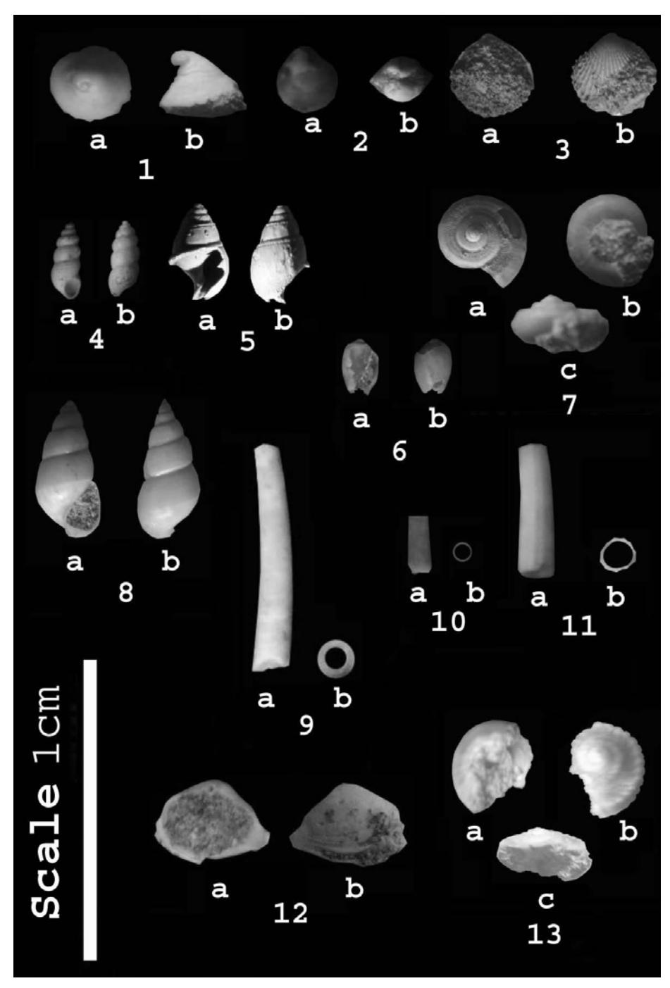
Figure 6 Some representative mollusk fossils found in stratigraphic sections (for taxonomic name see Table 1).
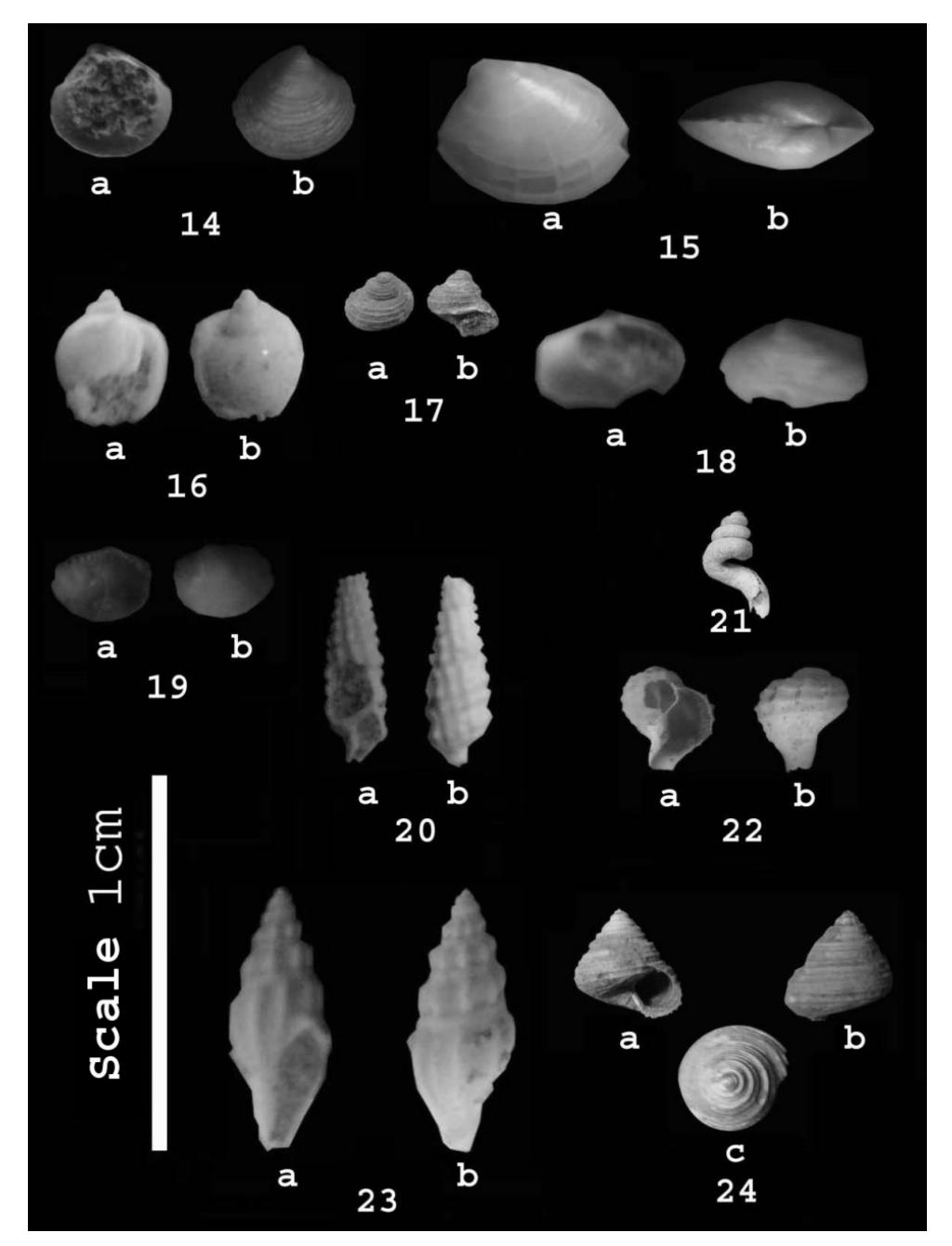
Figure 7 Some representative mollusk fossils found in stratigraphic sections (for taxonomic name see Table 1).
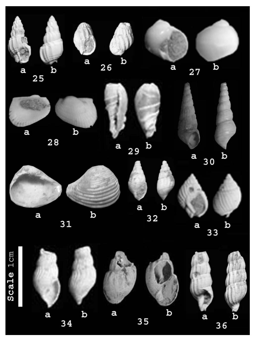
Figure 8 Some representative mollusk fossils found in stratigraphic sections (for taxonomic name see Table 1).
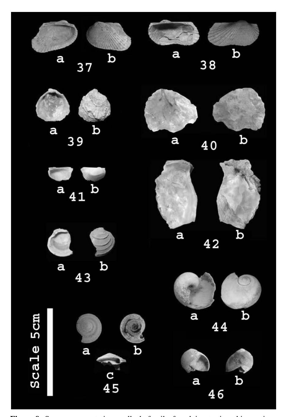
Figure 9 Some representative mollusk fossils found in stratigraphic sections (for taxonomic name see Table 1).
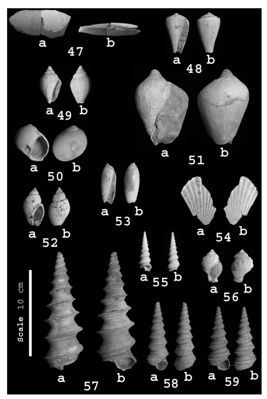
Figure 10 Some representative mollusk fossils found in stratigraphic sections (for taxonomic name see Table 1).
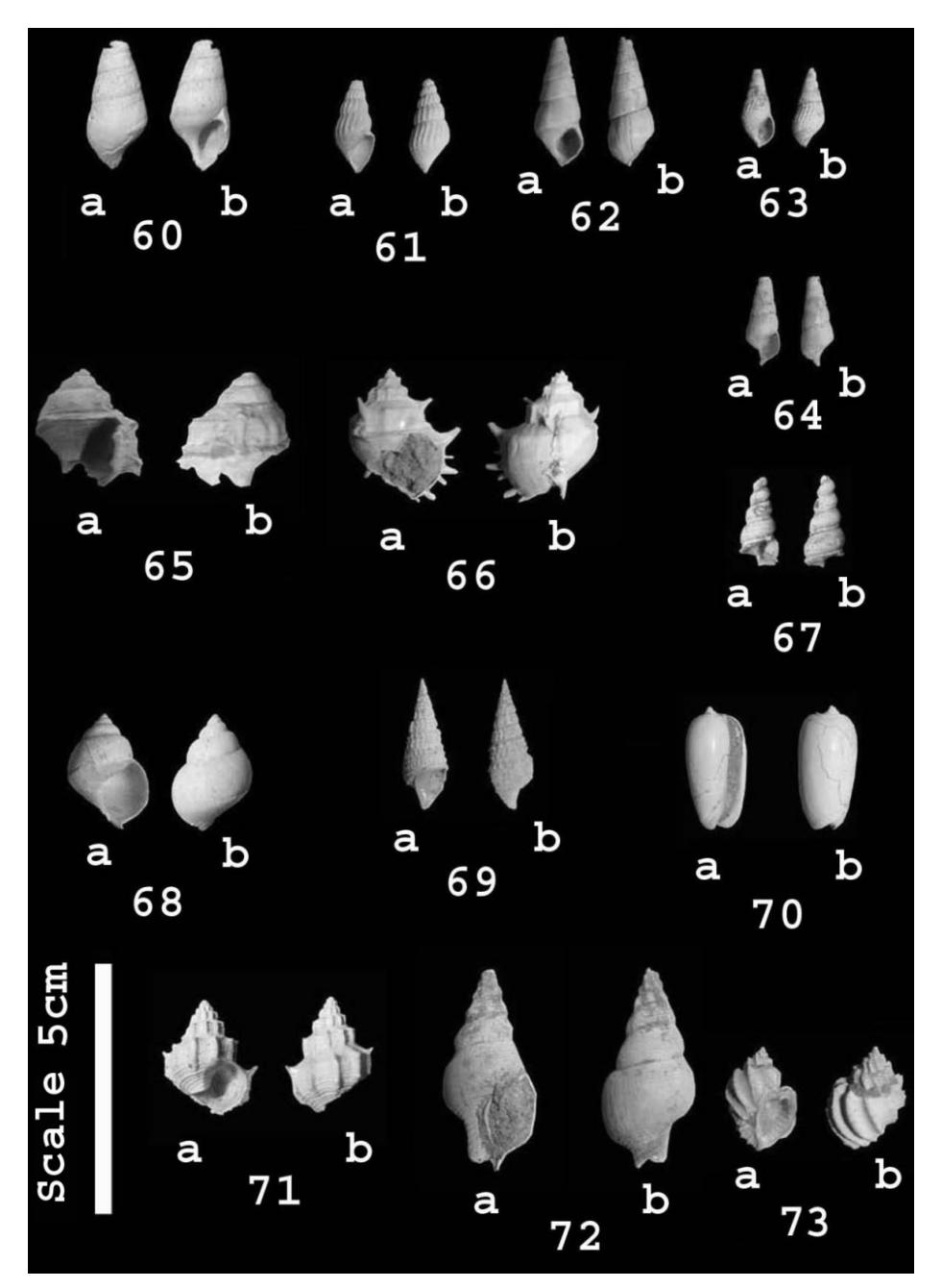
Figure 11 Some representative mollusk fossils found in stratigraphic sections (for taxonomic name see Table 1).
The paleontological study of the Bogor Basin was based on mollusk fossils derived from the Cibayawak section along the Cibayawak River in the area of Ujung Jaya, 25 km to the northeast of Sumedang City, West Java Province (Figure 1). The lower part of the stratigraphic section was interpreted as claystone and sandstone of the Kaliwangu Formation (Djuri [9] (Figure 12A), while the upper part was determined to be sandstone and conglomerates of the Citalang Formation (Djuri, et al. [4]). The lower part of the stratigraphic section contains marine mollusk fossils such as Turritella simplex (Figure 10, no. 57), Nassa ovum (Figure 8, no. 26) and Dentalium sp. (Figure 6, no. 10), whereas the upper part (interpreted as Pleistocene) is characterized by a very coarse grained lithology (conglomerate) without mollusks being present. Therefore, the upper part of the section is interpreted as consisting of riverine sediments (Figure 12B).
In this paleontological analysis, the Plio-Pleistocene North Serayu Basin is represented by the Kaliglagah section (Figure 4). This section was taken at the Kaliglagah River, located about 15 km north of the Bumiayu City, Central Java Province (Figure 1). The section is characterized by a change from marine mollusk fossils in the lower part into fresh water taxa in the upper part. The marine mollusks found in the lower part of the section are Turritella djajariensis (Figure 10, no. 58), Finella rufocincta (Figure 6, no. 4), and Solariella ambligoniata (Figure 6, no. 13). The marine intervals are dominated by greenish claystone with sandstone interbedded of Kaliwangu Formation (Kastowo and Suwarna [10]) (Figure 12C). The upper part of the section is rich in fresh water mollusks, such as Melanoides spp., Brotia oppenorthi (Figure 8, no 34) and Sulcospira foeda (Figure 11, no. 64). The lithology of this part of the section consists of very coarse grained sediments dominated by conglomerates (Figure 12D) and is interpreted as Pleistocene river deposits of the Kaliglagah Formation (Kastowo and Suwarna [10]).
Shallow marine molluscs obtained from the late-Pliocene lower upper part of the stratigraphic section are Tellina sp. (Figure 7, no. 18) and Paphia sp. (Figure 10, no. 47). Stratigraphic sections representing this basin were developed by forming composite sections from two adjacent locations. The lower part of the section was developed from the Kedungrandu location near Patikraja, an area that is located about 7 km southwest of Purwokerto City. This part is dominated by fine sand and was determined to represent the Bantardawa-Talanggudang Formation (Figure 12E). The upper part was observed at the Gunung Tugel location of the Patikraja area, about 3 km south of Purwokerto City. The lower part of the Gunung Tugel section consists of fine sand marine sediments (Figure 12F), whereas the upper part of the Gunung Tugel section consists of coarse sandstone and is interpreted as part of the Kaliglagah Formation equivalent (Figure 12G).
Figure 12 (A) Kaliwangu Formation outcrop in the lower part of Cibayawak section with molluscs, representing the late-Neogene marine sediments of the Bogor Basin. (B) Conglomerate of the Citalang Formation outcrop in the upper part of Cibayawak section, representing the early-Pleistocene riverine sediments of the Bogor Basin. (C) Kalibiuk Formation outcrop in the lower part of Kaliglagah section with molluscs, representing the late Neogene marine sediments of the North Serayu Basin. (D) Contact between greenish claystone (lower part) and conglomerate (upper part) of the Kaliglagah Formation outcrop in the upper part of the Kaliglagah section, representing the early-Pleistocene river deposits of the North Serayu Basin. (E) Bantardawa-Talanggudang Formation outcrop of the Kedungrandu section with molluscs, representing the late-Neogene marine sediments of the Bobotsari Low. (F) Bantardawa-Talanggudang Formation outcrop in the lower part of the Gunung Tugel section with mollusk fragments, representing the top of late-Neogene marine sediments of the Bobotsari Low. (G) Contact between fine sand marine sediments (lower part) and coarse sandstone (upper part) outcrop in the upper part of the Gunung Tugel section. The fine sandstone represents the top of the Bantardawa-Talanggudang Formation. The coarse sandstone is equivalent to the Kaliglagah Formation, representing the early-Pleistocene deposits of the Bobotsari Low that were influence by marine conditions during their deposition.
5 Discussion
Integrated studies of paleontology, sedimentology and stratigraphy of the three stratigraphic sections (Figure 3-5) in the Bobotsari Low and adjacent basins, indicate there was a slow subsidence during the Plio-Pleistocene in the area of Bobotsari Low compared to the other studied basins in the region. Analyses of the stratigraphic sections and their mollusk associations from North Serayu Basin and Bogor Basin indicate an abrupt uplift in the Plio-Pleistocene. This is based on the observed lithological contrast between fine grained shallow marine sediments with marine molluscs contained below and coarse grained sediments above (Figure 3 and 4).
Unlike in the other two basins, paleontological and stratigraphic analyses of the Bobotsari Low indicate that the marine influence lasted well into the late Pliocene/early Pleistocene. The ongoing marine influence on early-Pleistocene deposits in the upper part of the section is indicated by the presence of marine molluscs fragments, even though coarse grained sediments are present, which normally don't preserve fossils well.
6 Implications to Petroleum Geology
Slow subsidence in the Plio-Pleistocene of the Bobotsari Low is indicated by the presence of certain fragmented marine mollusk taxa. This allows for interpretations concerning petroleum geology. Slow subsidence is also indicated by the seismic section and well data of Karang Gedang-1 (KRG-1) retrieved from the Banyumas area, showing compression of this basin until the late Neogene (Lunt, et al. [2]). The high geothermal gradient that results from tectonic compression leads to increased maturity of the Neogene and Paleogene source rocks deposited within the compressed areas, which provide hydrocarbon windows more regularly than in adjacent basins.
Usman, et al. [23] analyzed the biomarkers of Maja-1 oil and early-Miocene (N4) samples from an outcrop at Cikaramas, Majalengka area. The early-Miocene Cikaramas rock sample has TOC 1.21 %. It appears from this that geochemically Maja oil can be correlated with the early-Miocene (N-4) Cikaramas source sample.
Noeradi, et al. [22] analyzed Halang and Pemali outcrop samples in the areas of Majenang and Bumiayu and found that generally the TOC of the samples was below 0.5% and the hydrogen index (HI) was below 200, indicating poor potential. Noeradi, et al. [22] also considered that numerous seeps in the area were supplied by Paleogene rather than Neogene sources.
Muchsin, et al. [21] analyzed early- to middle-Miocene Kalipucang and pre-Halang Formation outcrop bituminuous shales in the area of the southern Central Java region, near Bobotsari. The shales show a TOC of 0.7-15.63%, and Tmax of 400-440ºC (early mature-mature).
Based on the geochemical analyses representing the Bobotsari Low and adjacent basins it is here interpreted that the higher TOC in samples from Neogene outcrops have resulted from rapid burial in the Bobotsari Low due to the slow subsidence that continued into the early Quaternary.
7 Conclusions
Our analysis of Plio-Pleistocene mollusk fossils from Bobotsari Low and two adjacent basins from West and Central Java, Indonesia, supports the interpretation of the presence of marine-influenced conditions until the early Pleistocene in the Bobotsari Low, while adjacent basin environments were transitioning into terrestrial habitats (river systems). This result also supports the interpretation of slow subsidence in the Bobotsari Low that continued until the early Quaternary. Furthermore, the slow subsidence of the Bobotsari Low had a significant impact on hydrocarbon maturity compared to adjacent areas, including the Bogor and North Serayu basins. It is interpreted that the higher TOC in the samples from Neogene outcrops resulted from rapid burial in the Bobotsari Low due to the slow subsidence that continued into the early Quaternary.
Acknowledgements
The mollusk paleontological research data used in this study are based on the master thesis by Unggul Prasetyo in 2009. For aid in identification of specimens we thank Elina Sufiati from the Geological Museum Bandung. We wish to express our thanks to Prof. Dr. Eddy A. Subroto from the Faculty of Earth Sciences and Technology (FITB), Institute of Technology Bandung (ITB) for discussion on the petroleum geochemistry of some source rock from west and central Java and for provided literature. Dr. A.G. Beu and anonymous reviewers are also acknowledged for their useful comments for the improvement of this paper. We deeply thank Dr. Gregg Frederick Gunnell from Duke University (USA) for his useful suggestions that greatly improved the English text.