
Introduction
Growth in urban areas has been a major trend of urbanisation in the last 50 years, especially in developing countries. Importantly, urbanisation growth in the Asia region has contributed the largest proportion of urban populations in the context of overall world urbanisation trends (UN-WWAP, 2012). All evidence points towards those regions comprising developing countries being the focus areas of urban growth in the next 30 years, with China, India and Indonesia have been identified as having the highest urban population growth rates during this period (UN-HABITAT, 2011).
As urbanisation generates both positive and negative impacts on urban society and the environment, rapid urban growth in developing countries invariably implies some form of adverse consequences. Urban segregation and exclusion, for example, will become more complex in terms of their social, economic and spatial dimensions (UN-HABITAT, 2011). It is also acknowledged that urban segregation and exclusion have been key drivers in producing urban informality (Roy, 2005; Watson, 2009), which it has been argued results from rapid urban growth which distributes the least benefit to the poorer population (Watson, 2009; AlSayyad 2004 in Devlin, 2010). One result of the above is that urban space is subsequently produced by part of the urban population who have little concern and interest with formal planning rules, and by implication are excluded from such rules and regulations (Hall and Pfeiffer, 2000 in Roy, 2005; Jones, 2011). Recent planning literature confirms that urban informality is now a major mode of urbanisation, reflecting insights into how the processes of urbanisation unfold and play out in towns and cities (Roy, 2005; Porter et al 2011). As such, informality and its drivers should not be seen as separate elements of urban growth (Rukmana (2011) in Porter et al (2011)).
In the above context, this paper explores forms of urban governance emerging in the provision of urban services and infrastructure in Melanesia3 by comparing the situation in the mid-sized cities of Jayapura and Port Moresby. The paper identifies the increasingly informal nature of urban governance arrangements, particularly for infrastructure provision, which has been flourishing in both cities as well as the implications for future arrangement in urban management. The paper discusses the nature of urban governance, the rationale behind varying arrangements, and the impacts of various governance arrangements on broader city building processes. The paper concludes by acknowledging the importance of research into exploring forms of informal governance as a key contributor to urban development.
The Nature of Urban Governance
This paper defines the scope of urban governance as governance that encompasses both formal and informal arrangements that impacts upon resource allocation, enabling access and facilitating development (Nunan and Devas, 2004) and which "...encompasses a multitude of stakeholders that includes various levels of government, nongovernment organizations (NGOs), the private sector, civil society, donor organizations, and community groups" (ADB, 2012 p. 61). The scope of urban governance comprises individual citizens and households of all groups in as much as they have any influence over what happens in the urban domain (Nunan and 3 Melanesia is a subregion of Oceania extending from the western end of the Pacific Ocean to the Arafura Sea, and eastward to Fiji. The region comprises the countries of Vanuatu, Solomon Islands, Fiji and Papua New Guinea; New Caledonia; and the eastern part of Indonesia including provinces of Papua and West Papua.
Devas, 2004), thus delivering "… multiple social interactions through time, shaped by their histories, creatively adjusting to the flowing and changing context" (Healey et al, 2004 p.23). In the Pacific Region, urban governance has been viewed as a much broader concept than the government systems of urban administration, being terms misunderstood and misused (ADB, 2012). (see Box A).
As globalisation has accelerated, there has been increasing innovation in dealing with the complexity of management challenges in developing countries. This has occurred at the state, regional, local and increasingly at the communal group and household level as mainstream types of governance, such as "authoritarian" and "hierarchical" approaches, have failed in delivering services and welfare as promised (Chan and Hu, 2004). On one hand, spatial plans and policies are claimed to have a prominent role in managing these problems as they argue that they provide government the ability to intervene and support public interest, however defined (Friedmann, 1987 in David and Philip, 1998). The scope of public interest includes maximising the 'distribution of wealth' (David and Philip, 1998), 'city management' (You, 2007) and provision of infrastructure and services (Wahed, 2010). Thus, spatial plans and policies may assist the government to improve city welfare and prosperity. On the other hand, it is also admitted that traditional forms of public intervention has contributed in widening the social, economic and other 'gaps' amongst people and groups (Harloe, 1992; Watson, 2009). Groups with lower level of income remain neglected and not facilitated in the formal process of spatial plans and policies, thus accentuating the urban divide as rapid urbanisation proceeds and plays out in varying ways (UN-HABITAT, 2011).
Box A: Urban Governance in the Pacific Centre Context
"It is thus not surprising that "urban governance" and "urban management" are terms neither well understood nor familiar to Pacific bureaucratic institutions or the public-at-large. Urban governance is the conduit by which residents and groups - including government - voice their concerns, exercise their legal rights, debate, resolve their differences, and fulfill their obligations. Urban governance thus encompasses a multitude of stakeholders that includes various levels of government, nongovernment organizations (NGOs), the private sector, civil society, donor organizations, and community groups."
Source: ADB, 2012: 61.
Accentuation of the urban divide tends to push the marginalised and those already disadvantaged into the realm of 'informality' especially in terms of accessing public infrastructure and services needed for their survival (Altrock, 2001; Jones, 2012). In fact, 'conflicts between the logic of governance and government and the logic of survival' (Watson, 2009) - in other words, the disconnect between government plans and policies and implementation on the ground - has provided a window for these marginalised groups to mobilise themselves so as to fulfill their needs. What is increasingly clear is that urban development and the provision of public services and infrastructure is not merely the result of government intervention through formal processes, but also the result of a myriad of informal processes in society (Nunan and Devas, 2004; Healey et al, 2002).
In the Pacific Region, it has been acknowledged that urban governance encompasses two parallel forms of urban governance that operate in tandem: (i) urban governance based on formal state systems supported by systems of public administration and bureaucracy, both necessary for achieving the development objectives of the formal government; and (ii) urban governance anchored on traditional practices and customs. This includes structures and system that have their roots in social affinity and connections to family, place and landowning groups. Examples of traditional local governance mechanisms mainstreamed in the formal system are village courts, the scale of political power afforded local leaders, and, more recently, the establishment of local government committees in urban settlements and greater involvement of churches in local governance processes. The intersection and overlapping of the formal and importantly informal governance systems in increasingly recognised as a critical and legitimate component of city development (ADB, 2012).
In this context, increasing informal urbanism in respect of how urban governance plays out in many towns and cities in developing countries should be seen as an inseparable part of the urban development processes. Instead of viewing this phenomenon as a deviation from formal mainstream planning, informal governance should be acknowledged as critical building block in facilitating 'bottom up' approaches which allows urban citizens to take part in decision making processes and arrangements which contributes to improving their urban quality of life. Therefore, a better understanding the nature of urban governance in varying city contexts is essential to understanding and conceptualising the process of city building and its wider social economic, environmental and political dimensions.
Case Studies
Jayapura, Papua, Indonesia
The urban population in Indonesia has increased significantly during the period 1980-2010, rising from 22% of the total Indonesian population in 1980 to approximately 49% in 2010 (Firman, 2012). The largest concentration of both populations and urbanised areas remains focused in Java Island (BPS) with other islands such as Kalimantan and Papua remain least populated. Consequently, Indonesia has to deal with several issues concern with balancing patterns of urbanisation, including adequacy of urban infrastructure and service provision, as well as problems related to imbalances in human development disparity.
Papua is the least developed province in Indonesia, remaining last ranked in the country in terms of the Human Development Index (HDI) (BPS, 2012). Also in regard to levels of poverty, Papua is also the poorest province of the country, with 32% of its population classed as living in poverty in 2011 (BPS, 2012).
Formal planning policies to accelerate the development process in Papua have been carried out by the Indonesian government, including enacting Law 21 of 2001 concerning the 'Special Autonomy for Papua' (which includes both Papua Province and West Papua Province). According to Law 21, Papuans are prioritised to receive special rights, such as priority in access to education, health, infrastructure, gender equality and opportunities for community empowerment4 . Furthermore, a large number of territorial delineations have been put in place during the last decade, thus dividing the province from 11 counties and 2 cities in 2001, to 28 counties and 1 city in 2011 (BPS, 2012). This policy as contained in Law 21 has contributed to 4 Definition of Papuan according to Law 21 of 2001 includes people from Melanesian ethnic groups in Papua Province and or people who are accepted and admitted as Papuan by Papuan Community Groups.
an accelerated urbanisation process as towns were designated as focus areas for urban growth and development.
The capital city of Papua Province, Jayapura, started to grow significantly after the city was enacted as an autonomous administrative area in 1993 (Kambu, et al 2009). Unlike Java Island and other growth centres which have experienced declining urban growth, Jayapura maintains the largest proportion of urban population in Papua, with a total population of 236,476 persons in 2010 (BPS, 2012b). Jayapura also has the highest growth rate of population in Papua Province, approximating 4.4% annual growth (BPS, 2012). Furthermore, in terms of spatial development, Jayapura is the most urbanised in the province with approximately 97.68% of its population living in the defined urban area.
Jayapura was modeled on a Dutch planning approach during period of the early 1900s to the period approximating World War I (Kambu et al. 2009; Siagian, 1978). The first modern settlement was built in 1909 by the Dutch Government initially for military use. In the World War II period, the Dutch Government put in additional infrastructure and services to support their military purposes and administration systems. Under Indonesian government during the period of the New Order Government, that is 1962-1998, the region began to experience increasing disparity especially in regard human and spatial development.
The formal planning system in Jayapura comprises two major planning mechanisms, namely, spatial planning and development planning. Both forms of planning have different scope and spatial application at the national, provincial and local level as well as application across differing time periods5 . The arrangement of spatial plans, including their preparation, implementation and evaluation is based on Law 26 of 2007, namely, "Spatial Management" in which all types of should comply with. The unconformity with approved spatial plans and policies will result in legal and administrative consequences. Citizens' engagement in the preparation of formal spatial plans arrangement is regulated by Government Regulation 68 of 2000. In contrast to spatial plans, development plans contain policies and actions of government in providing infrastructure and other public services in the short, medium and long term in which government is the main facilitating stakeholder. The procedures and process of preparation, implementation and evaluation of development plans, including the community engagement are based on Law 25 of 2004 concerning "Development Planning" which falls under the ambit of the Planning Boards at all levels. Both spatial and development plans have their own evaluation mechanisms. The evaluation of spatial plans, often called spatial plan "review", is conducted at least every 5 years during implementation (Art 25 Law 26 of 2007). Development plans, in contrast, have an annual evaluation process which is conducted by the Planning Boards, Supervisory Boards and Treasury Board.
In Jayapura, spatial plans and policies have not been implemented effectively for a range of reasons. Due to resource limitations and other factors, the City Government has identified only a limited number of priorities for development, for public service and infrastructure development6 . Consequently, Jayapura continues to experience a trend that has been named
5 Spatial planning mechanisms are based on Law 26 of 2007 about Spatial Management, aimed at managing land use planning system, while development planning mechanisms are based on Law 25 of 2004 about National Development Planning System aimed at managing development planning, budgeting, implementation and evaluation.
6 Regarding development plans, analysis on mid-term development plans for the period 2008-2012 shows that city government has put priorities regarding development sectors and location. Major sectors are infrastructure (34%), general sector (23%) and education (18%), while health and economy sectors share
'spontaneous settlements' (Scargill, 1979), namely, the 'illegal occupation' of private or state land (including slums) in several parts of the city. The polarisation of a limited number of spatial plans and policies being applied to a select few areas, rather than citywide, has accelerated the urban divide however defined. One consequence of the above is that those most affected by the skewed development and implementation of the spatial plans and policies are the urban poor who by exclusion and/or needs develop their own ways to meet their community and household requirement.
In Jayapura, it is estimated some 25% of the population, namely, approximately 60,000 persons lives in informal or unplanned settlements7 . The informal settlements in Jayapura have emerged by taking up urban space within, between and contiguous to the planned areas of the city. This includes settlements which sprawl out from the fringe areas of the city. In all these areas, informal settlers occupy land without formal or legal permits from the owners or the government. On undeveloped land in the planned areas, settlers build shelters and kiosks in public spaces, such as parks, waterways, and on vacant land. The buildings and development use invariably do not comply with city planning and building regulations, often being developed on lands classed as marginal under the formal planning system. This includes steep and hilly areas (including power easements) or other areas prohibited for urban development according to the spatial plan.
Lands are illegally developed for settlement not only by migrants from other parts of Papua or wider Indonesia, but also investors large and small who build modern housing and commercial buildings in such locations. Since these settlements are considered illegal under the formal planning system, the issue of land titles and access to formal public infrastructure and services is constrained, thus development occurs in an ad hoc manner. As spatial plans recognise these areas by identifying them as unplanned, development plans mark such areas as 'least priority' in terms of the provision of urban infrastructure and services, including roads, drainage, water, sanitation and electricity.
Informal settlements in Jayapura can be classified into several groups according their location, types of resident and housing quality. In terms of location, informal settlements are located in two major areas, namely, the urban centres and the urban fringe. Informal settlements in and adjoining the built up urban centres take up public lands such as parks, roadside reserves, pedestrian paths, river floodplains, and coastal area in urbanised districts such as North Jayapura, South Jayapura, Abepura, and Heram. Settler groups have encroached onto formal public facilities, such as the city markets in Entrop, Gurabesi, Dok IX, Hamadi and the public transport terminals in Youtefa and Entrop. This included modifying space in these areas to residential use.
On the urban fringe, informal settlements are built in areas designated for conservation, including adjoining high valued mangrove reserves. In terms of housing quality in fringe areas, houses in the settlements are resided by mainly Papuan settlers have semi-permanent low quality. On the other hand, houses owned and built by Papuan and migrants from other islands which are located in urban centres and coastal mainly built with semi-permanent and permanent the least. District Abepura and Muara Tami have been the main locations for development as with total 288 and 235 projects respectively in the last five years, while District Heram has the least number of development projects in the same period.
7 Estimate by authors based on overlapping aerial maps of existing settlements and Jayapura City Plan 2008.
material, providing average to good quality housing stock. Some of these houses obtain use permits from traditional owners as well as agreeing terms of land acquisition. There is no incentive to adhere to formal rules and regulation in these settlements since these are regarded as illegal development.
As a general trend, settlers living in adjoining the urban centre have their place of origin from the western provinces of Indonesia, while settlers occupying the fringe areas come from other localities in Papua, or West Papua Province. Settlements have no formal land status since they are built on state land or private land without consent of the land owners and are considered illegal according to the formal system. Despite the overarching of all land ownership types, settlers often use informal or written permits from communal and traditional holders to occupy land. The permits are obtained by providing certain compensation to the tribal community for the land and use security. Such compensation includes cash, in kind, or share of interests in the development. This arrangement often triggers conflict between the government and settlers and the indigenous community (keondoafian) as each case is unique and outside the boundaries of government "one size fits all" approach.
Formal land governance in Jayapura is based on Law 5 of 1960 about Basic Agrarian Law, which puts the National Land Board as the institution responsible to manage all types of land tenure and mediating land disputes. Several tenures acknowledged by the Law are state land, private or corporate land and traditional communal land (tanah adat). Particularly Papua, Law 21 of 2001 recognises traditional communal land as one of the formal land tenures. Thus, all parts of land and water in Papua have their traditional tribal ownership embedded in their formal land status. In wider Indonesia, the implementation of formal land arrangements focuses mainly on state and private ownership, with lesser attention paid to traditional communal land (Daryono, 2010). The result is a duality of land systems contributing to a plethora of informal governance systems in Jayapura.
In seeking to address increasing informality of settlements in Jayapura, the City Government attempted to enforce building and development control regulations by enacting City Regulation 5 of 2008 (General Spatial Plans). The latter detailed spatial plans comprise building regulations and development controls as well as the legal and administrative consequences of illegal use, occupation and development. Nevertheless, the implementation of rigid government regulation has not resulted in the decline of informal settlements including use or development; rather they have continued to accelerate in their expansion. As the City Government applied the Spatial Plan according to Law 26 of 2007 in 2008, informal settlements have flourished in the city areas due their exclusion from the planned development expansion areas.
A review of City Spatial Plan, 2012, shows that approximately 25% of the city area remains unplanned with informal housing of various kinds dominating this city area. Thus, attempts by City Government to implement spatial and development plans at a city wide level has had minimal affect especially in terms of public infrastructure and services (BAPPEDA Kota Jayapura, 2012). Contributing to this intrusion, there has been major alteration of city conservation areas by settlements. According to the Regulation of the Minister of Forestry 782/2012, conservation areas have been reclassified, including critical land from 85.5% to only 36.13% while increasing the area for urban development from 14.9% to 43.65%8 . Thus, instead
8 These numbers are based on overlapping analysis on Jayapura Spatial Plan according to City Regulation 5/2008 and draft for Jayapura Spatial Plan 2012, conducted by BAPPEDA Kota Jayapura.
of acting as disincentive of growing informal settlements, these regulations have opened the opportunity for settlers to further spread out across the city.
Within the above setting, settlers have developed their own mechanisms in providing public services and amenities so as to meet their communal and household needs. This includes access to public infrastructure and services such as water, electricity, waste disposal. Regarding water supply, settlers build their own piping system delivering water from local springs to their houses using polyethylene pipes and rubber hoses, as can be seen in some areas such as APO, and Dok IX. There is no formal arrangement among users, adopting instead mutual unwritten and oral agreements about how they share and manage such resources.
Since the users comprise settlers from various ethnic backgrounds, it is often the head of neighborhood or community unit that takes responsibility to manage such arrangements. In some areas such as Buper Waena, Angkasa, Dok V, Dok IX and Pasir II, Papuan migrants build settlements next to water springs. Thus, the availability of a reliable water source is a key point for settlers when occupying land for settlements. Since many settlements are based on particular ethnic clans primarily from Papua, settlers develop more tribal based mechanisms in the use and management of water by replicating traditional rules brought from their original village and place of origin. Thus, it is common for the head of tribal groups ("big men") to be in charge of these high demand basic public services. Some other settlers also access clean water by make illegal connection to the public system owned by PDAM or City Government9 often by calling on favours by relatives.
Picture 1. Household self-helped water pipes in APO Bukit (Photo: BAPPEDA Kota Jayapura, 2013)
In addressing these gaps, Jayapura City Government has taken part in various initiatives. One such as initiative is a national program of poverty alleviation called the National Program for Community Empowerment (Program Nasional Pemberdayaan Masyarakat-PNPM) (PNPM, 2013)10. Focused on Papua and West Papua, this program has two major schemes: PNPM Urban and PNPM Respek, the latter designed in relation to the special autonomy policy for this 9 Verbal communication of BAPPEDA with users in Angkasapura 2009, and APO Bukit and Dok IX, 22 August 2013.
10 The program was funded by Indonesian national budget and a soft loan from World Bank (World Bank, cited 25 July 2013) focusing on projects that addressed environmental, social and economic improvement.
province. PNPM Urban is primarily funded by the regular annual government budget, while PNPM Respek is funded by the Special Autonomy Budget11. PNPM Urban in Jayapura was initiated in 2007 by carrying out programs in 7 Kelurahan (sub-districts). The number of kelurahans or kampung and community groups involved in the program consistently increases to 39 in 2013. The number of volunteers also increases from 578 persons in 2007 to 2087 persons in 2010 (BAPPEDA Kota Jayapura, 2013). However, the sustainability of the projects in supporting the longer terms needs of communities remains uncertain.
Picture 2. PNPM Urban in Jayapura (Photo: PNPM Kota Jayapura, 2013)
Hybrid governance in Jayapura is a manifestation of governance emerging from a mix of formal and informal systems. Indigenous communities take responsibility for managing natural resources such as eco-tourism, as well as trading stores, plus organising urban security. In respect of natural resource management, indigenous clans are recognised as the traditional land owners (pemilik hak ulayat) can manage tourism destinations in their localities, such as the beaches in Base G, Hamadi, and Skouw and Lake Sentani. They also work with the City Government on the provision of infrastructure such as roads and water (BAPPEDA Kota Jayapura, 2012). Papuan women working as street vendors apply traditional arrangements and protocols in sharing space for kiosks in urban centres, notwithstanding they face the threat of eviction in using public spaces as a location for trading12. . In regard to urban security, indigenous youths share responsibility with migrant groups in ensuring urban safety and security, especially at religious occasions. It is common in Jayapura that the Christian Youth Community be responsible for managing/regulating traffic flows and ensuring neighborhoods on Eid Day and Chinese New Year are safe13 .
11 Jayapura City Government is responsible in managing both schemes at municipal level. Coordination for conducting projects in infrastructure, economy and social improvement is the City Planning Agency
(BAPPEDA) which has developed coordinating teams for Urban Poverty Alleviation. 12 Papua Province government has provided space for traditional trading for Papuan women in urban centre of North Jayapura in 2009 addressing their aspiration for obtaining broader involvement in urban economy as enacted by Law 21 of 2001.
13 Result of author's individual observations during 2001-2012.
Port Moresby, Papua New Guinea
While PNG may have the lowest rate of urbanisation in the Pacific Region – approximately 13% in 2000 - it has both the highest number of urban residents and largest number of towns and cities in the Pacific Region, namely, three formally declared cities (Port Moresby, Lae and Mt. Hagen) and seventeen provincial towns (Office of Urbanisation, 2010). In the most reliable recent census in 2000, the Port Moresby population was 254,158 persons, or just over one third of the then PNG urban population of 675,403 persons (National Statistics Office, 2003). In 2008, the Port Moresby population was estimated at approximately 410,000 persons (UN-HABITAT, 2008), and at the end of 2012 was estimated to account for approximately 50% of the national urban population of one million persons, namely, around 500,000 to 600,000 persons.
In terms of formal government systems, Port Moresby sits within the National Capital District (NCD), a province of some 240 km2 classified as urban, and containing peri-urban villages and a rural hinterland. Between 1980 and 2000, the annual average growth rate of Port Moresby was 4% percent, with some 58% of the NCD population being migrants from other provinces. The 2000 census estimated 90% of these migrants had moved to Port Moresby in the 1990-2000 period, with most migrants taking up occupation in the settlements (Chand and Yala, 2008). This population movement continues today in varying forms, and has contributed significantly to a landless class of settlers living in a plethora of settlements in and around Port Moresby (Office of Urbanisation, 2010).
The population growth of Port Moresby is increasingly located in growing settlements (Pyati, 2013). Like other towns and cities in PNG, settlements continue to expand and develop without adherence to formal rules and regulations of NCD (Alaluku, 2010). Port Moresby's settlements are located on both State and customary land, with approximately 40% being customary, and 60% being on freehold or State land. The customary land in Port Moresby is owned by the coastal dwellers, the Motu Koita clans, and in 2006 accounted for some 37 settlements (NCDC, 2006).
In 2006, the National Capital District Commission (NCDC) estimated some 40% of the Port Moresby population were living in a range of settlement types (NCDC, 2006). In 2008, it was estimated 45% of Port Moresby's population, namely, around 185,000 persons, lived in 99 settlements comprising 20 planned and 79 unplanned settlements (UN-HABITAT, 2008). This aligns with earlier estimates that indicated some 50% of the Port Moresby population lived in varying squatter settlements scattered throughout the city (UN-HABITAT, 2004). In 2000, there were only 55 settlements, and thus by 2008, settlements had been expanding at a rate of around 5 to 6 new settlements per year. Some researchers, such as those at the National Research Institute of PNG, have suggested that the number of new settlements being added each year in Port Moresby is as high as 20 (Anis, 2010). By July, 2013, it was estimated there were over 140 plus settlements scattered throughout the Port Moresby urban area, containing some 50% plus of the urban population (verbal communication, Office of Urbanisation, July, 2013).
The NCDC defines settlements in Port Moresby into three categories, namely, formal, squatter and Motu Koita settlements (NCDC, 2006). The NCDC categorises a squatter settlement as "a spontaneous community or cluster of families who initially invade or progressively settle in and make use of property, or a site, or area of land without consent of the rightful owners" (NCDC, 2006 p. vi). The Motu Koita settlements are the original indigenous villages of Port Moresby as occupied by the traditional landowners, the Motu Koita. These village settlements have been developed under the auspices of customary law and have expanded and grown over time by both natural population increase as well as by the influx of new migrants. On the other hand, the formal settlements refer to areas of low cost self-help housing provided with limited infrastructure on State land, the latter often put in place after the initial development. Whilst in the minority, the formal settlements reflect a form of 'retro planning' or in situ urban renewal, upgraded on the basis of formal planning and building standards. However, the amenity of the formal settlements varies, with unmaintained dwellings, environmental degradation and uncollected rubbish increasingly becoming the norm as population increases and housing is increasingly overcrowded. As such, the delineation between 'planned and unplanned' in formal and squatter settlement areas, plus the Motu Koita settlements, is increasingly unclear.
It is increasingly documented in the literature that settlements are characterised by varying forms of governance, poor quality housing and minimal infrastructure, primarily water and power, with illegal connections common comprises the most extensive land use in the settlements (ADB, 2012; Chand and Yala, 2008a; Jones 2012a; Pyati, 2010), with most houses constructed of traditional, semi-permanent and permanent materials. Although there are new permanent houses being built in some settlements, most settlers reside in self-help temporary houses, including run down vacated buildings which become their permanent places of shelter (UN-Habitat, 2008). There is much trading in land as well as housing, despite the insecurity and informal status of land agreements. Land transactions by customary owners have become increasingly common as they 'sell' their land and or the use of their customary land for attractive cash payments (Chand and Yala, 2008a).
Settlements that have emerged on State land are effectively acquired by land invasion and occupation, while on customary land there exists both 'sale and purchase' of land rights and housing, and to a lesser degree, occupation by force. Despite the lack of clear title to land, an absence of secure land tenure does not constrain informal development including land dealings (Chand and Yala, 2008a: 2012). This view in Port Moresby is supported by recent work in squatter settlements in Fiji, which indicated a continuum of use rights and arrangements exists, which may or may not constrain settlers in developing their land (Kiddle, 2010).
There is a range of infrastructure and services provided by varying means in the Port Moresby settlements. In the older established settlements which date back to the 1950s and 1960s, there are churches, community halls and recreation areas. Water is supplied to those who can afford a connection fee by Eda Ranu, the National Capital Development (NCD) water supplier. With the support of wider clan, kin and family groups in the settlements, households break water pipes and make their own connections to households, while others may share a public standpipe, or mix thereof. Although most settlements are outside of the NCD sewerage system, settlers use pit latrines, septic styled systems, or where location allows, the sea or bush, with only few households having flush toilets (Jones, 2012a).
All settlements have roads, mainly unsealed, and a reliable system of Public Motor Vehicles small mini buses - which ensure ready access to all parts the city, including the many settlement markets and formal shopping centres. Where space and land suitability allows, subsistence activities supplements household diets and goods are sold in settlement markets. Approximately one third of settlements have access to reticulated electricity, with Easi Pay (prepaid electricity) being common in the settlements (NCDC, 2006). Not surprisingly, there is little or no compliance and enforcement of planning and building provisions, with formal NCDC town plans and policies having little relevance on the lives of those residing in settlements. This is apparent in all settlements including the traditional Motu Koita villages such as Hanuabada
Tatana, Taikoni, Vabukori and Gereka, which have existed before the establishment of Port Moresby and developed along customary lines (Pyati, 2013). As a result, the formal NCDC development plans for Port Moresby do not reflect a unified approach to development of the settlements because they remain viewed as illegal and temporal (UN- HABITAT, 2008)
Picture 3: Settlers sourcing water from broken water pipes in Eight Mile settlement, Port Moresby (Photo: Scott Pelletier)
Formal government structures and systems have little impact on those living in the settlements for a range of reasons. Because of this illegality, participation in NCDC planning, budgeting, policy and decision making is virtually absent in the settlements. Under the NCDC Act, ward councilors are appointed rather than elected representatives, with many allocated to political cronies. Councilors also have little influence at the higher NCDC levels (Pyati, 2013). As a result, local governance arrangements and systems continue to strengthen, representing a complex set of groups and village committees, overlain in some settlements by elements from formal institutions. Recent studies in Port Moresby have shown that settlements, despite their ad hoc appearance and irregular layouts to many outsiders, are far from "haphazard and disorganised" (Chand and Yala, 2008a p. 149). Governance arrangements have evolved to regulate, control and monitor settlers seeking approval for basic land planning and local infrastructure needs, such as allocating plots for housing, gardening, churches, market places, mini stores and public water supply standpipes, as well as ensuring vehicle and pedestrian access is not obstructed. Local governance systems embedded in committee systems, "chiefs and big men" ensure urban security issues including law and order, are met often along traditional lines (Jones, 2012a).
In all of the above matters, including land tenure and land occupation, basic communal and individual rights as accepted by settlement communities are informally defined and enforced within the local contextual setting. The common theme in all of Port Moresby settlements is that settlers coalesce into groups and develop their governance arrangements based on clan, kin, region, plus influences that filter through professional and educational ties. The socio-cultural norms and values of the ethnic and clan group strongly frame how they go about their daily lives and meet their individual and collective governance needs. Importantly, land tenure type, length of settlement occupation, population size, and the relative heterogeneity and homogeneity of the settlement population by type of ethnic group and allegiance to a village, locality or region, all strongly influence the stability of the settlement and its governance arrangements.
Formal government institutions such as the Village Court system, developed in the British and Australian colonial era, is one of the modern institutions that still co-exists in the settlements, especially in the older squatter settlements and native (urban) villages, namely, the Motu Koita villages (Chand and Yala, 2012). Churches also play a strong unifying and stabilising role in maintaining governance systems in many settlements as do the presence of the police (Pyati, 2013).
In the above context, a key advantage for individuals and households in settlements in Port Moresby is that they are not relatively powerless as kinship based governance arrangements including wantok systems play a crucial support role for people and households especially those in hardship. As observed, governance systems are more effective and united where settlements grow along tribal and ethnic origins, such as in the case of Four Mile Settlement, for example, where settlements represent enclaves, or a series of enclaves, of kinship support from settlers originating from the Southern Highlands (Jones, 2011; Mawuli and Guy, 2007). This clustering into settlements based on kin, village and related regional affiliations is common across all of Port Moresby, as well as other larger centres in PNG. In Port Moresby's Gorobe settlement as established in the early 1960's, for example, some 54% of household heads come from Gulf Province, 23% from Central Province, while the remaining settlers come from Madang and Western Province (Chand and Yala, 2008a). Not surprisingly, the myriad of settlements of Port Moresby have been described as "cosmopolitan networks of tribal groupings or anarchical subcultures, which have been defined by ethnicity and regionalism within an urban context" (Muke et al, 2001 p. 7).
With the growth of settlements and "village world" bottom-up governance arrangements in Port Moresby, politicians are both reluctant and wary to modify the fabric of "informal" governance operating in settlements (Jones, 2012b). As many settlements have been long established, governance structures and systems have been developed over time including recognising occupation agreements of landowners and other 'occupiers' (legal or illegal depending on one's perpective). This includes sanctioning of practices which allow access to basic water supply and power (Jones, 2011). With increasing hardship in urban areas, the priority for many governance arrangements in settlements is focused on meeting the family, household and 'urban village' needs necessary for survival, including land, housing, sustaining livelihoods and urban security. Traditional based systems are often best placed to meet these needs.
Senior kin and clan statesmen who have attained reputation and respect, such as chiefs and "big men", play important roles in mediating, representing, and politicising the views of particular clans, settlements, and urban districts (ADB, 2012). This includes politicians who invariably have ethnic and kinship ties to settlers, and who are called upon to assist with household and social enclave issues regarding land, housing, or cash contributions for food, school bills, and travel back to rural villages for funerals or festivities. Resolving these 'here and now' activities take on greater social relevance and importance in local governance arrangements, rather than addressing wider NCDC and national government urban development plans and policies (Jones, 2012a). With increasing hardship and poverty, maintaining unity of governance arrangements as the demand to sell or to distribute assets such as land and housing increasingly come under pressure by settlement members. In this setting, politicians and "big men" are acutely aware of the unknown consequences of tampering with established and often sensitive local governance arrangements based on kin. These can, arise in settlements when grand and sometimes alien
western plans, such as those promoted by development banks at a national and city level and need to be implemented locally, lead to disputes that did not openly exist. This includes elevating underlying and simmering land and clan leadership challenges (Jones and Lea, 2007).
Results and Main Findings
The proliferation of unplanned settlements in Jayapura and Port Moresby with their own systems of decision-making and wider governance arrangements reflect deep seated change that is evident across a myriad of both Indonesian and Pacific towns and cities. Such change is most prevalent in the deteriorating urban setting of the larger Melanesian towns and cities, such as Port Moresby (Connell and Lea, 2002; Jones and Lea, 2007). The permanency and extent of settlements, combined with the inability of formal government systems to address the depth of both existing town and city issues (including future urban growth scenarios), all contribute to the emergence of hybrid forms of governance arrangements. While some researchers have portrayed settlements as being outside the bounds of the 'legitimate city' (see, for example, Watson, 2009), they are increasingly more and more representing the 'real city' as planned development under formal governance arrangements becomes a minority concept. The emerging trend is an increase in settlements in both number and size, accompanied by varying systems of governance to meet the demands of their urban experience. "Because …. that is normal, that's what there is. That's their urban fabric, that's their urban village" (Jones, 2013 p.21).
The reality is that a multitude of different actors, stakeholders, institutions and arrangements, formal and informal, however defined, contribute to the building of the dynamic city (Nunan and Devas, 2004). In both case study examples, a high diversity of ethnic groups have contributed to the development of varying models of urban governance, reflecting adaptation of both western and local Melanesian governance unique to their urban experience in their city contexts.
Some literature argues that city governance can be classified as formal and informal, with informal arrangements being a deviation of the planned, and regulated formal systems (Jones, 2011; Hall and Pfeiffer, 2000 in Roy, 2005) (see Figure 1). The intersection between both realms is acknowledged as both an acceptance and toleration from the government to the increase of urban informality due to an inability to provide adequate public infrastructure and social services to the overall city population. Alternative governance arrangements fill the gap where formal government is considered irrelevant or not meeting a need. This can be seen in Port Moresby, for example, where wantok systems remain strong in influencing the management of settlements, including how village committees and "big men" resolve disputes regarding land, housing and access to public utilities within the settlements. On the other hand, formal government in Jayapura has made efforts towards integrating traditional governance in respect of land maters and formalising community village groups.
Figure 1: Traditional view on urban governance—operation of separate entities
The result of this preliminary analysis indicates that there are both commonalities and differences in the systems of urban governance in Jayapura and Port Moresby. In terms of commonalities, both systems are characterised by:
- Strong colonial influence: the British Australian system in Port Moresby, and Dutch-American systems in Jayapura.
- The poor performance of formal governance institutions and processes which are out of step with meeting current quality of life needs.
- The deteriorating physical and social condition of towns and cities generally.
- A plurality of governance systems which manifest themselves to varying degrees and effectiveness within the settlements.
- Communities which 'borrow' from each system those elements which are best placed to meet their needs.
- Multitude of stakeholders involved in different arrangements of city building.
- Diversity of ethnic groups, within many ethnic groups having strong links to rural areas, as well as with the urban areas themselves.
In terms of differences between the systems of urban governance, system of governance has been influenced by:
- Speed and pace of urban growth and urbanisation.
- 'Strength' of formal and informal systems that operate in local contexts.
- Degree of hardship and poverty.
- Depth of traditional and western values and norms persistent in the wider society.
In both examples, it can be well argued that while they may be classed as informal, they are still planned and regulated according to varying local governance systems comprising rules, regulations, norms and values (see Figure 2).
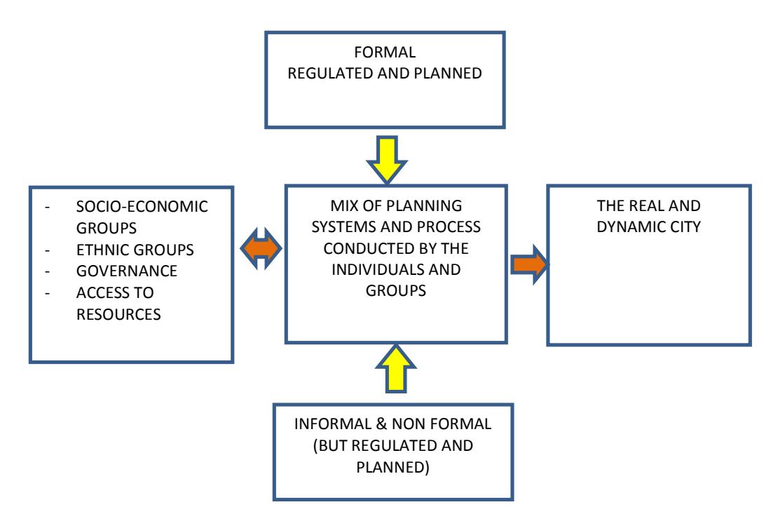
Figure 2: Emerging Perspective on Urban Governance
Conclusion
In summary, formal urban governance in Melanesian cities has resulted in not only the implementation of western bureaucratic style plans and policies, but also the rise of informal urbanism as expressed in a diversity of informal governance arrangements. The inability of formal government to recognise and meet the urban needs of the overall city population correlates strongly to the varied forms of informal urban governance now emerging at both different spatial levels, and in settlement forms.
Various initiatives have been suggested to address growing quality of life issues in settlements, especially their implications for urban management, service and infrastructure delivery. These include making more formal land available, such as customary land as being piloted with landowners in Port Moresby and elsewhere in PNG, and formalising settlements on customary and State lands (AusAID, 2008: Jones, 2013). In Jayapura, establishment of practical guidelines of land management as enacted by Law 5 of 1960 and Law 21 of 2001 is crucial in managing issues between formal and informal land tenures. Further exploration of the differing forms of governance as evolving in different contexts, the commonalities and differences will contribute to a better understanding of the nature of urban governance. This includes options to support settlements in the more effective provision of urban infrastructure and services and their overall management including basic human development gains.
Reaching the above position requires a major shift in the mindset of many researchers, policy makers, politicians and development partners in their perception and understanding of how governance really works in the building of the contemporary city. Relooking at both formal(planned) and informal(unplanned) settlements through different governance and management lenses will continue to be a paramount and an overdue challenge for development partners, governments and other stakeholders in Indonesia, PNG and the broader region.