
Introduction
Population growth and the need for housing and settlement are impacts that will always follow urban development. However, as a natural component with finite characteristics, at one point, urban land will be unable to accommodate the demand for urban facilities, including the demand for housing. This has implications for the expansion of housing development in the outskirts of the city. The periphery, which was originally a rural area, slowly changes in its physical, economic and social characteristics, gradually becoming more urban. This process is described as peri-urbanisation (McGee, 2005). In this case, the peri-urban area can be defined as a transition area between urban and rural activities, where this region is characterized as a mix of land uses and unclear inner and outer boundaries and is generally a combination of several separate administrative regions (Ginting, 2010). Peri-urban areas in East Asian metropolitan regions are rarely a unified spatial feature and its transformation tends to be triggered by formal land development, often in large scale (Hudalah, Winarso, & Woltier, 2007).
Changes in the characteristics of the peri-urban area, within a certain time period, will result in a transformation of the region. Regional transformation is a representation of a region's development as a process of change and the shifting of characteristics of the area's components within a certain time frame as a result of the reciprocal relationship between the area's components (Giyarsih, 2009 in Hardati, 2011). Yunus (2008) in Krismasta, Rogi, & Tilaar (2015) explains that the transformation of peri-urban regions involves spatial/ physical and socio-economic transformations. Spatial transformation of peri-urban regions involves aspects of land use, accessibility, and completeness of available infrastructure (Kurnianingsih & Rudiarto, 2014). Meanwhile, socio-economic transformation can be seen in aspects of population density and the livelihoods of its inhabitants. In this study, the peri-urban transformation will be discussed based on the spatial aspects. This focus on spatial aspects is to see the development of the built up area in the outskirts of the city over time as a manifestation of the physical propagation of the town center spreading to the peri-urban areas.
The transformation that occurs as a result of land use conversion in peri-urban regions is generally followed by an increase in land value. Land value is described by Astuti (2014) as a manifestation of land capability in relation to its utilization and use. Verheye (2009) divides land value into the categories of natural value (productive land), economic value (real-estate) and ecological value (parks and environmental conservation). In the peri-urban context, a phenomenon that often occurs is a change in land use from productive land to land with economic value, followed by a very significant price increase. Land price is a representation of the economic capacity of land and its value is measured by a nominal price in currency units (Astuti, 2014). At the level of land economy, land values are synonymous with land prices because the price of land is the manifestation of the value of land (Hermit, 2009 in Tilaar, 2013). In this case, the economic value of the land is not viewed in terms of activity and economic growth, but in terms of the property commodities.
One peri-urban region that has experienced a rural-urban transformation is the Gunung Batu Dalam area which is the border area between the western part of Bandung City and the northern part of Cimahi City. In this region, the transformation process has started since the early 1980s. In the beginning, this region was a natural stone quarry, agriculture area, and small-scale rural settlements. Since 1982, developers successively started to move in to conduct land acquisition which was then followed by housing and settlement development. Currently, the region has become a residential settlement area, where most of these residents are migrants. The spatial transformation was followed by higher land prices that are increasing yearly. In the early years of development, the price of developed land in this region was Rp. 12.500,-/m <sup>2</sup> and this has continued to increase, currently reaching Rp. 4.000.000,-/m <sup>2</sup>.
Previous studies on the transformation of peri-urban areas have discussed the topic more in terms of environmental change and socio-economic aspects of the communities (Dewi & Rudiarto, 2014; Ginting, 2010; Hardati 2011; Krismasta et al., 2015; Kurnianingsih & Rudiarto, 2014; McGee, 2005; Nugroho, 2014; Sari & Winarso, 2007). Research on peri-urban land prices has been carried out by Mulyanti (2015) and Tilaar (2013) but focussed more on analysis of the correlation between spatial transformation and increases in peri-urban land price instead of researching the extent of the contribution of the increase in peri-urban land values for the government. Therefore, this research will specifically study the processes of regional spatial transformation in the context of rising land prices and Land-Tax Object Sales Value (NJOP Tanah) to then assess this in comparison with the increase in the real value of the land itself. This assessment is important as a source of information for the public and policy makers in relation to the added value obtained from the shift of land function that occurs in peri-urban regions. Through this research, it will be known whether the increase in land value is proportional to the increase in benefits for the government related to the conversion of land function in peri-urban areas, which are an asset in protecting the environment in urban areas. To calculate the economic land value, this study will compare the market price with the Tax Object Sales Value of the land, starting from the early years of land development until today.
Methodology
This research was conducted using mixed methods approach between quantitative and qualitative methods. Data was collected through primary and secondary data collection. Primary data was collected through interviews with field informants in the Gunung Batu Dalam area to determine the market price of land over the last 10 years. Secondary data was obtained from the thesis report Proses Pasar Tanah dan Tatanan Ruang Permukiman di Kawasan Gunung Batu Dalam (Land Market Processes and Settlement Spatial Arrangement in the Gunung Batu Dalam area by Vitriana, 2005), Land and Building Tax (PBB) documentation, as well as the geographical maps of the region. Based on the data obtained, descriptive-explorative analysis was conducted to explain increases in land prices and Land-Tax Object Sales Value (NJOP Tanah) based on the region's spatial conditions.
In processing and analyzing field data, first, a quantitative approach was used to calculate and obtain a comparison of real price and land price based on the Tax Object Sales Value and the market price scheme. Then, to further clarify the results of the quantitative data processing, further analysis was conducted using a qualitative approach.
Results and Discussion
The start of the development of housing and settlements in the Gunung Batu Dalam area is the result of the expansion of activities in the city of Bandung. At the beginning of development, the area was administratively part of the Administrative City of Cimahi, Bandung Regency. The area was used for natural stone mining, agriculture and small scale rural settlements. Nonetheless, the primary activity in this region was the mining of natural stone. Only a small part of the region was used as an agricultural area and for residential settlements. Since the development of several infrastructure projects in the western part of Bandung City, which includes the Hasan Sadikin Hospital and Indonesian Aerospace (IPTN), this began to slowly change the use of the surrounding area. Gradually, new small-scale residential housing began to appear in the western border area of Bandung City. Currently, the Gunung Batu Dalam area is becoming increasingly densely populated. An illustration of the spatial transformation of the area can be seen through an overview of conditions of the area recorded by aerial photography in 1987, 2003, 2010, and 2015 (Figure 1).
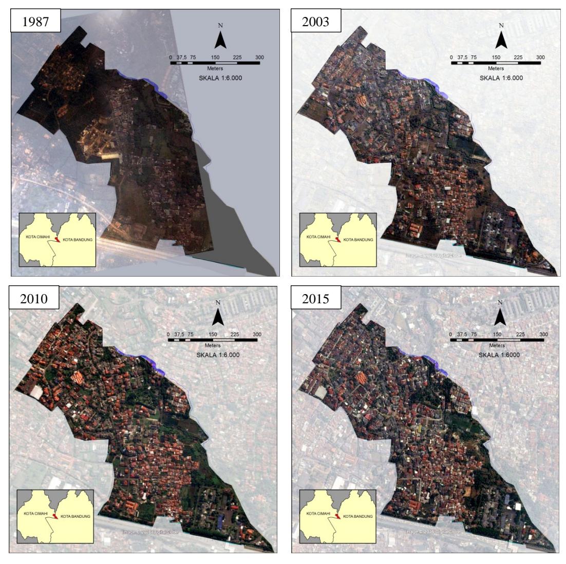
Figure 1. Spatial Transformation in the Gunung Batu Dalam area Source: Analyzed from Pasir Kaliki Sub-District Office (1987) and Google Earth
In 1987, the stone mining license for the Gunung Batu Dalam area was revoked. Although formally there has been no shift in the function of the area, the revocation of the permit has accelerated the process of development of the region into a residential area. In 2001, the Administrative City of Cimahi changed status to become an autonomous city. Based on Regional Regulation of the City of Cimahi no. 32 on Cimahi City Regional Spatial Plan, this area is formally a low-density residential area with a maximum Building Coverage Ratio of 40%. The size of the Gunung Batu Dalam area is + 34.42 Ha. At the beginning of land development, only 11.62% of the land was used for rural settlement by local residents. Currently, vacant land, which was formerly non-settlement land, has been converted into urban residential areas with clusters of residential complexes. Only 11.62% of the land still remains as a residential settlement of locals, however, with a higher density.
The process of spatial transformation the Gunung Batu Dalam area began with the construction of the Pondok Padent Complex (1980-1981) followed by Cidamar Permai Complex (1983- 1986), Jasa Marga Complex (1984-1986), Citra Asri Complex (1989-1990), Gunung Mas Complex (1991-present), Citra Asri II-AURI Complex (1991-1993), Setra Asri Complex (1996 present) and finally the expansion of Setra Duta Complex (2004-present). An interesting phenomenon in the development of this region lies in the order of location acquisition and land development which did not happen sequentially with its access to the main road (Jalan Gunung Batu Dalam). During this period land prices in the Gunung Batu Dalam area began to increase. The process of spatial changes and increases in land prices that occurred during the acquisition and construction of housing by developers can be seen in Figure 2.
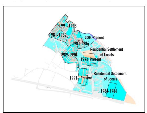
Figure 2. Map of Land and Housing Development in the Gunung Batu Dalam area Source: Results of Map Processing
While the process of spatial transformation took place, land prices have increased significantly every year. An overview of the increase in built-up land area with the increase in land prices of both Land-Tax Object Sales Value and the market price of the land can be seen in Table 1.
According to the Table 1, the spatial transformation occurring in the Gunung Batu Dalam area started in 1981. The increase in land prices began after the construction of the Padent housing complex. The opening of access to paved neighborhood roads in the region, built by the developer of the Cidamar Permai Complex in 1984, did not greatly impact the increase in land prices. Instead, significant increases in price started in early 1990. Based on further examination to the reason behind this, the increase in land price at that time was mostly influenced by external factors, such as the development of external infrastructure, in this case, the construction of the Padalarang-Cileunyi toll road which caused the widening of the area's main road. An increase and improvement of accessibility in the surrounding area have become a pull factor for city residents to live in this area.
Table 1. The order of housing development in the area of Gunung Batu Dalam in the period of 1981-2015
| Year | Housing Development | Relative Percentage of the Size of Built-up Land | Internal Facilities and Infrastructure Built | Land Market Price (per m²) | Land-Tax Object Sales Value (per m²) | External Facilities and Infrastructure |
|---|---|---|---|---|---|---|
| <1980 | Kp. Cidamar (4 Ha) | 11,62 | Stone/dirt road | (No information the land price a Object Sale | and Land-Tax | |
| 1981 | Pondok Padent (0.9 Ha) | 14,23 | Housing complex road | Rp. 12.500,- | Rp. 3.575,- | - |
| 1982 1983 | Rp. 3.575,- Rp. 3.575,- | |||||
| 1984 | Cdmr Permai Complex (0.6 Ha) | 15,98 | Neighborhood road, Housing complex road,Park (Green Open Space) | Rp. 15.000,- | Rp. 3.575,- | Paving of Gunung Batu Dalam Road |
| 1985 | - | Rp. 3.575,- | ||||
| 1986 | Jasa Marga Complex (0.5 Ha) | 17,43 | Housing complex road, Park (Green Open Space) | Rp. 30.000,- | Rp. 4.320,- | - |
| 1987 1988 | - - | Rp. 4.320,- Rp. 4.320,- | Construction of Padalarang | |||
| 1989 | Citra Asri Complex (1 Ha) | 20,33 | Housing complex road | Rp. 50.000, | Rp. 4.320,- | Cileunyi Toll Road starts |
| 1990 | (1 1111) | - | Rp. 4.320,- | Troug Starts | ||
| 1991 | Gn. Mas Complex (1.1 Ha) | 23,53 | Housing complex road | Rp. 200.000,- | Rp. 5.832,- | |
| 1992 | Auri Complex (2 Ha) | 29,34 | Housing complex road | Rp. 200.000,- | Rp. 15.753,- | Padalarang Cileunyi Toll |
| 1993 1994 1995 | - | Rp. 48.000,- Rp. 48.000,- Rp. 200.000,- | Road officially open | |||
| 1996 | Setra Asri Complex (1.26 Ha) | 33,00 | Housing complex road | Rp. 300.000,- | Rp. 200.000,- | Angkot St. Hall – Gn. Batu |
| 1997 1998 1999 | , | Construction of mosque | Rp. 243.000,- Rp. 243.000,- Rp. 243.000,- | |||
| 2000 | 34,74 | - | Rp. 500.000,- | Rp. 243.000,- | ||
| 2001 2002 | - - | - | Rp. 335.000,- Rp. 335.000,- | |||
| 2003 2004 | Expanding of Setra Duta | 36,66 | Housing complex road | Rp. 1.000.000,- | Rp. 394.000,- Rp. 394.000,- | |
| 2005 2006 2007 | - | Rp. 394.000,- (No PBB information obtained) | ||||
| 2008 | 38,12 | Construction of | Rp.1.750.000,- | Rp. 614.000,- | ||
| 2009 2010 | 23,12 | artesian well | F 2 01000, | Rp. 702.000,- Rp. 916.000,- | ||
| 2011 2012 | - | Rp. 916.000,- Rp. 916.000,- | ||||
| 2012 2013 2014 | - | Rp. 916.000,- Rp. 916.000,- Rp. 916.000,- | ||||
| 2014 | 39,87 | Rp. 4.000.000,- | Rp. 916.000,- |
Source : Vitriana (2005) and Land and Building Tax Documentation (PBB) 1981 – 2015
Note: No information obtained about the land market price. In this period, construction of houses was carried out individually (either through informal or formal processes)
The same trend is shown in the increase in Land-Tax Object Sales Value (NJOP Tanah) which occurred significantly in the period from 1992 until 1996. Based on the above data, three housing complexes were developed in this period. The land price increase is a phenomenon that affected most peri-urban areas in Indonesia during the 1980s and 1990s, as described by Firman (2000) as the effect of a property boom. In this era, an economic boom caused many residential areas and settlements, particularly downtown slum areas, to be turned into hotels, luxurious high rise apartments, and shopping centers. This increase in land prices in the central business districts quickly turned fringe areas of large cities into residential areas and settlements, industrial areas, golf courses, and resorts for tourists (Firman, 2004 in Kusumastuti, 2005). This shows that the increase in housing construction in the Gunung Batu Dalam area is also caused by a property boom, in addition to infrastructure developments in the surrounding area.
The monetary crisis that hit Indonesia in 1997 had a nationwide impact on the property sector. However, land prices in the Gunung Batu Dalam area still increased during the period of the crisis, although, this increase was not significant, as described by Vitriana (2005). The monetary crisis did not really affect the upward trend of land market price increase in the area. However, the opposite occurred for Land-Tax Object Sales Value. Based on the data obtained, regional Land-Tax Object Sales Value remained the same from 1997 to 2000. This means no increase in the land value was attributed to the area by the government during the period.
From 1997 spatial changes began to slow down. The great majority of the land was already controlled and built by the developers. What remained were relatively small scale individually owned parcels of land that had not been developed by their owners. Regional physical development was more directed at the improvement of regional infrastructure and individual development of prepared land plots. In 1998 a mosque was built and in 2008 a regional artesian well was constructed. After the year 2000, the market price of land in the region again showed a sharp increase. This was predicted as an effect of recovery of the economy and business property after 2000 (Kusumastuti, 2005).
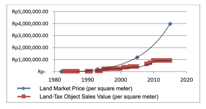
Figure 3. Comparison of Land Market Price Increase and Land-Tax Object Sales Value in the Gunung Batu Area. Source: Data Processing
The rapid increase in land prices in this area are not directly proportional to the trend of increasing Land-Tax Object Sales Value (NJOP Tanah). Based on the above data, the increase in Land-Tax Object Sales Value moves very slowly compared to the increase in the market price of land. In 2015, the price difference between Land-Tax Object Sales Value and the market price of land reached a four-fold difference. An overview of the imbalance between the market price of land and Land-Tax Object Sales Value in the Gunung Batu Dalam area can be seen in Figure 3.
The Figure 3 above shows that in the Gunung Batu Dalam area, the imposition of Land-Tax Object Sales Value since the beginning of the land development of the area has been below the standard market price, however, the difference was not significant. The imbalance between the land market price and Land-Tax Object Sales Value began to increase significantly since the economic crisis in 1998. At that time, the increase in the market price of land continued to rise while the Land-Tax Object Sales Value was stagnant. Based on Land and Building Tax data collected, the trend in Land-Tax Object Sales Value increase is irregular from year to year. This phenomenon might occur as one of the impacts of the implementation of Law Number 28 Year 2009 on Regional Taxes and Fees of which Article 79 paragraph 2 states that the amount of Tax Object Sale Value is determined every 3 (three) years by the Regional Head, except for areas with fast development, then the increase of Tax Object Sales Value can be faster than every 3 years.
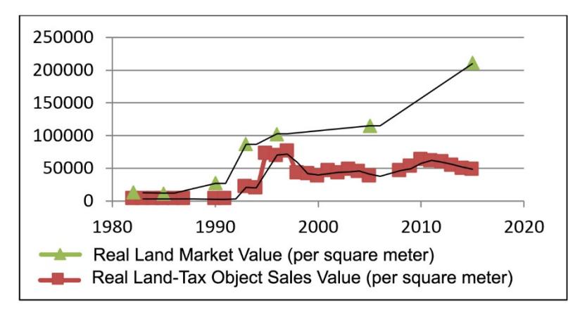
This phenomenon implies that when Tax Object Sales Value is in a stagnant position in a certain period of time this causes the government to suffer potential lost revenue twice. First, a large gap between the market price and the Tax Object Sales Value indicates the government's failure to regulate the source of state revenue. Tax Object Sales Value forms the basis for determining Land and Building Tax (PBB) and the Land and Building Transaction Tax (BPHTB). Second, when a price tends to stagnate at a certain position then the real value of that price declines given the fact each year currency value is subject to inflation. As Winarso (2007) in Hudalah, Winarso & Woltier (2007) by his research of land development at Bumi Serpong Damai emphasises the result of the dynamic of the market-driven land prices has violated the tax-based land prices as regulated by the local government. A comparison of the increase in real value of the market price of land with the increase in real Land-Tax Object Sales Value in the area Gunung Batu Dalam can be seen in Figure 4.
Note:
- 1. Calculations of the real land value take into account yearly inflation which was converted in the parameter of value in the first year of development (1981)
- 2. Inflation rates are based on data from the Central Statistics Agency and Sadikin (2010)
Figure 4. Comparison of Real Land Market Value Increase and Real Land-Tax Object Sales Value In the Gunung Batu Dalam area. Source: Data Processing
The graph above was obtained by charting the Land-Tax Object Sales Value data while taking into account the increase in inflation. Based on this figure, it is clear that the movement of
Land-Tax Object Sales Value tends to be slow and unstructured. It is completely contrary to the facts on the ground that indicate that peri-urban land market value constantly increases and even moves outside the ordinary increase of land. The simulation shows that since the monetary crisis, the government did not obtain a reasonable income from the increase in the market price of land in this region.
When looking at other impacts of spatial changes in the Gunung Batu Dalam area, these spatial changes gradually began to cause environmental degradation in the center of the region as well as in the environment of the surrounding area. Along with the spatial expansion of settlements, the region's main neighborhood road since the late 1990s started to experience frequent floods after heavy rain. In this case, environmental degradation is a result of the immaturity of the plan/regional development concept. Due to this, developments were not followed by adequate regional infrastructure development. An example of this is the construction of roads without adding adequate drainage facilities. Besides this, the area has already started to experience drought during the rainy season due to the lack of water infiltration, given the fact that 8 housing clusters were built, only two of which have their own facilities for green open space. Other green open spaces only consist of building plots that have not yet been developed by their owner and yards of residential houses. The direct impact felt by the public is the difficulty of clean water availability during the dry season due to a decrease in ground water level. To overcome this, in 2008 the local government has built an artesian well in the area. Other environmental degradation consists of the emergence of congestion that is getting increasingly worse from the west toward downtown Bandung due to an imbalance between the number of vehicles and road capacity.
Referring to the many things that are happening, governments may need to review their policy in developing the peri-urban land. Peri-urban areas were originally rural regions with the majority of the areas undeveloped. In these conditions, peri-urban areas not only have productive value as fulfilling the demand for food (paddy fields) but are also ecologically valuable in regulating water reserves, carbon sequestration in the air, etc. (Verheye, 2009; Hariyanto, 2010 in Dewi & Rudiarto, 2014:1). The Bandung City Regional Regulation No. 8 Year 2008 on Regional Long Term Development Plan (RPJPD) Year 2005-2025 (Bandung, 2008), Appendix Chapter II on the General Overview of Bandung explains that in the last 20 years there has been a decline in rainfall, an increase in average temperature, an increase in air pollution, increased water runoff, a decrease in groundwater quality and quantity, and increased transport activities as a result of the spatial development of the city of Bandung.
Based on the above phenomena, the increase in spatial transformation in the peri-urban area can be viewed from a positive and negative side. From the positive side, the spatial transformation is not only capable of tackling the problem of urban housing demand, but also capable of creating many employment opportunities and economic multiplier effects (Webster, 2002 in Winarso, Hudalah, Sari, & Novastara, 2008:1). While from a negative perspective, this peri-urbanization is seen as an image of uncontrolled and unsustainable development (Webster, 2002 in Winarso et al., 2008). In line with this, Firman (2009) explains that land conversion could in turn bring both direct and indirect impacts, which includes loss of agricultural land, the loss of investment in irrigation infrastructure and the influx of population into fringe areas from urban ones. From those sides, that is to say that the impact of the negative effects of environmental degradation in peri-urban areas are more obvious than the expected benefits.
Conclusion
The study shows that increases in land prices caused by spatial transformation in the Gunung Batu Dalam area will have a different meaning when viewed from the perspective of the government and society. From a societal perspective, the price increases brought a significant annual increase in value. This also leads to many investors/land speculators to utilize the increased economic value of peri-urban land. From the government's perspective, the price increase has no impact on the value that should be obtained by the government. The increase in prices is not directly proportional to the revenue obtained by the government on the added value of peri-urban land. The phenomenon that occurs shows that an increase in peri-urban land prices can become one of the potential losses of local revenue.
Suggestions and Recommendations
To address the problem, two alternative solutions can be used as input for local governments, namely:
- 1. The government should be able to control the increase in the market price of land. If not, then the base for land tax should be in accordance with the prevailing market price. If this is enacted, the government is expected to earn an appropriate amount of revenue where these benefits can be used to overcome the environmental problems posed. However, to be able to apply this alternative, the government should be able to solve the other impacts, which are the increasing marginalization of native peri-urban inhabitants whose socio-economic capabilities are far below that of the urban migrants in general. If this principle is applied, the government should be ready to apply the concept of mitigating the environmental impacts of peri-urban development through strategies and further planning in order to reserve the land needed for the ecological equilibrium of the peri-urban area in particular, and the urban environment in a broader scope.
- 2. In order to preserve the environment, the government needs to strictly maintain the productive and ecological value of peri-urban areas by limiting peri-urban land use for urban activities. Therefore, the government should be consistent with the rules enacted which were created with the purpose to regulate land use in peri-urban regions. Peri-urban regions should no longer be considered as a solution for spatial expansion of housing. To solve the problem of housing in urban areas, the government has no choice but to plan settlements vertically.