
Introduction
Tourism shows a positive development trend towards global and national economic growth. Tourism in Indonesia is ranked the fourth export sector contributing most to the country's foreign exchange earnings. It also has a positive trend over the past 5 years compared to the higher ranked sectors that show a decreasing trend (Ministry of Tourism, 2014). In its development, tourism is no longer confined to natural destinations but develops by viewing cities as potential destinations that have a comprehensive infrastructure and greater accessibility as well as their own tourist market. Moreover, cities are the places of entrance and transit to other tourist destinations (Inskeep, 1991; Pratiwi, 2011, 2008). Urban tourism is considered to have its own market because cities generally have large populations so it has the potential to attract friends and relatives which in tourism terminology is known as visiting friends and relatives (VFR) (Hayllar et.al, 2008). The magnitude of this market potential allows tourism to be developed in urban areas through optimization and development of attractions that can provide employment for the local community (Gunawan, 2004).
In line with this, this article will discuss the study to support the development of tourism in Pekanbaru City. Pekanbaru is the capital of Riau Province which is better known as a business city. However, the city, in fact, has another potential for development of tourism, such as cuisine, unique Malay culture, museums, and the Siak River that divides some cities/regencies in Riau. Tourism in this city has not developed into a leading sector, which can be seen from the absence of a Master Plan for Regional Tourism Development (Ripparda) and the condition of attractions that are not maintained causing city residents prefer to go on holiday out of town or abroad (Kabar24.com, 2015).
The Siak River clearly has the potential for the development of tourism areas on the riverfront. The study location focuses on Kampung Bandar and Kampung Dalam Urban Villages located in the city's cultural heritage area (Senapelan Sub-district) and has much undeveloped tourism potential. This study will focus on a discussion of the elements of developing riverfront tourism areas by modifying the theories of Wren (1983, in Yassin, 2011) and Toree (1989, in Tangkuman et. al., 2011) which consist of geographical factors, themes, image, authenticity, function, public perception, accessibility, and effective management. These elements are analyzed qualitatively and quantitatively based on questionnaires given to the community and visitors, observations, and interviews. Based on the analysis, the study location already fulfills these elements and could be the beginning of riverfront area development in Pekanbaru. Nevertheless, to transform the area into a tourism destination that is ready for the arrival of tourists still requires a strategy. This article will also formulate recommendations for the development of this new riverfront tourism destination.
Literature Review
Development of areas near water is part of urban regeneration. The relations between rivers or other water sources and cities often show a complex interaction of various elements, including the development of tourism around the river, hereinafter referred to as riverfront tourism. This terminology comes from the term waterfront, which is more common and widely used. A waterfront is an area bordered by water in various forms, this can be a river, lake, ocean, bay, tributary, or canal, even man-made water (Timur, 2013). The term riverfront is used in this study to clarify that the study is carried out in the waterfront area of a river. The theory used in this study is the basic principle of successful waterfront area development by Toree (1989, in Yassin, 2011) and Wren (1983, in Tangkuman et al., 2011).
- Function
- Function as a recreational area such as a culinary center or entertainment center by providing pedestrian paths to reach the area.
- Image
- Image can be interpreted as a representation of an object. Implementation of the theme will create a regional image. The image of the area can be formed by five main elements, i.e. path, edge, node, landmark, and district.
- Themes
- The theme is determined by several considerations, such as climate, spatial planning, design, land use design, land use development, and culture and history.
- Geographical factors
- Geographical factors include waterway conditions (the type of river), tidal and water conditions, land and ownership conditions, and climate which includes types of seasons, temperatures, winds, and rainfall.
- Authenticity
- Maintaining the value of authenticity of the waterfront area and the surrounding region is important in planning the waterfront area.
- Accessibility
- Accessibility is related to the road network and transportation facilities used from and towards the planning site.
- Public perception
- Combining theme, image, authenticity, environment, and finance should take into account local communities to avoid future problems.
- Effective management
- Good management should include experts from diverse fields, and coordination between them is necessary, both for the development of private and public waterfront areas.
Methodology
The research approach is a combination of quantitative and qualitative research (mixed-method research). A quantitative approach was used to analyze the perception of the local community and visitors on the development of riverfront tourism areas in Pekanbaru using questionnaires. Meanwhile, a qualitative approach was used to analyze the constituent elements of riverfront
areas and to formulate a development strategy using observations, interviews, and analysis of the questionnaires.
Data collection was conducted through field observations, questionnaires, and interviews. Field observations were conducted to observe the existing condition in the study location. Questionnaires were administered to determine the perception of the community as the supply side as well as visitors as the demand side. Questionnaire data is part of the final project titled Riverfront Tourism Area Pekanbaru, Riau: Development Strategy based on Community and Visitor Questionnaires. Questionnaires for 90 community members and 104 visitors, with questions covering socio-demographic information, travel characteristics, and perceptions of the riverfront tourism area. Meanwhile, interviews were conducted with relevant parties such as the Regional Development Planning Agency (Bappeda), the Culture and Tourism Agency (Disbudpar), and local tourism communities.
Study Location
Senapelan Sub-district is one of the sub-districts located right in the center of Pekanbaru and is directly adjacent to the Siak River. The study location focuses on two urban villages that have various tourism potentials i.e. natural, cultural, and man-made attractions, namely Kampung Bandar and Kampung Dalam. The natural tourist attraction is the Siak River which is one of the few locations with natural tourism potential in Pekanbaru. This river has an average depth of 29 m with a length of 300 km. The development of the riverbank as a tourism area will support revitalization efforts to improve the river's original function which has been neglected.
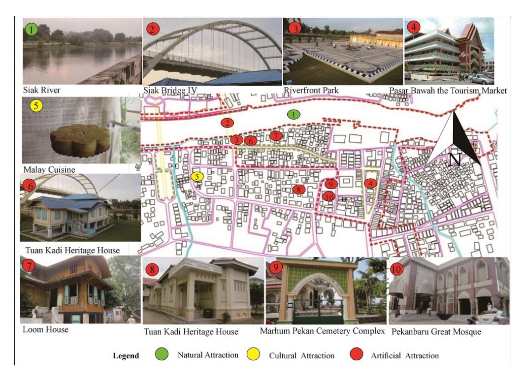
Figure 1. Distribution of Riverfront Tourist Attractions Pekanbaru. Source: RTBL Pekanbaru City, processed 2016
Man-made tourist attractions consist of the bridge over the Siak, the Waterfront Park located directly at the riverside, the Tourism Market Pasar Bawah which has become a center of Pekanbaru souvenirs, Tuan Kadi Heritage House which is a remnant of the Kingdom of Siak, the Loom House which can no longer be found in Pekanbaru, Marhum Pekan Cemetery Complex where the founders of Pekanbaru are buried, and Pekanbaru Great Mosque which is the first mosque in Pekanbaru and a remnant of the Kingdom of Siak. Cultural tourist attractions comprise local culture such as Malay cuisine, traditional art, and culture of Petang Megang which is still maintained as local wisdom in welcoming the holy month of Ramadhan. The distribution of attractions can be seen in the map on Figure 1.
Discussion
Summary of Community Interviews and Visitors Questionnaires
Questionnaires were given to affected communities and visitors in the study area (Table 1). This article will describe some of the data obtained from the questionnaires as part of the aforementioned Final Project.
Table 1. Summary of Results of Community and Visitors Questionnaire
| Category | Public Perception | Visitor Perception |
|---|---|---|
| Public knowledge of riverfront development plan | Aware (41%), unaware (59%) | - |
| Willingness to engage in tourism activities | Willing (96%), unwilling (4%) | - |
| Approval of tourism development | Agrees (100%) | - |
| Community activities around the river | Trade (31%), fishing (29%), transportation (18%), and recreation and sports (17%), others: bathing, cleaning, etc. (5%) | - |
| Attractions visited | History, art and traditional culture (45%), shopping centers (20%), the natural beauty of the Siak River (13%), local customs (12%), culinary center (10%) | Nature tourism (22%), cultural history tourism (21%), shopping (18%), traditional crafts (16%), culinary center (15%), traditional arts (8%) |
| Favorite activities | - | Leisure (39%), cultural history tourism (30%), culinary center (13%), nature tourism (9%), sports (2%), others (7%). |
| Facilities that have been provided | Good road access (42%), public toilets (24%), open spaces (16%), public transport (16%), direction signs (1%), and signs of entrances (1%) | Open space (34%), good access (20%), public transport (16%), direction signs (16%), public toilets (11%), and signs of entrances (3%) |
| Additional attraction | Floating culinary market (50%), cultural centers (26%) sports facilities (19%), homestay (2%), others (3%) | Floating culinary market (37%), sports facilities (28%), cultural centers (28%), homestay (5%), others (2%) |
The outcome of the questionnaire is used as the basis for analyzing the success of the development of the riverfront tourism area, supported by the data obtained from field observations and interviews.
The Elements of Successful Development of Riverfront Tourism Areas
The elements that can support the success of a development program for a tourist destination on a riverbank is based on a modification of the theories of Toree (1989) and Wren (1983). It consists of 8 elements comprising function, image, theme, geographical factor, authenticity, accessibility, public perception, and management.
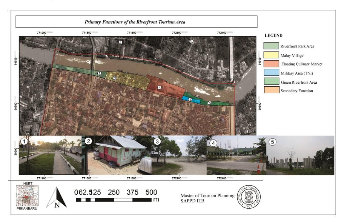
Figure 2. Primary Functions of the Riverfront Tourism Area
1. Function
Area functions that can support tourism activities consist of primary and secondary functions. The primary function of the area focuses on areas located right on the riverbank of the Siak whereas the secondary function is other tourist activities aimed at the city. Primary area functions include (Figure 2):
- Recreational functions around the waterfront park The waterfront park is located right on the riverbank of the Siak. This park is a gathering place for city dwellers, especially in the afternoon to relax while enjoying the river scenery (Damanik, 2016). However, there is no activity that visitors can do to increase the length of their visits and spending while in the park. Attractions that can be added to the waterfront park to support the visitor's favorite activities while in the area include a pedestrian bridge, pedestrian paths, water transportation and a riverfront culinary center.
- Floating Culinary Market A floating culinary market is a new attraction that can be added to become a new riverfront tourism icon in Pekanbaru (Damanik, 2016). The floating culinary market will possibly be located in the former port of PT Pelindo located close to Pasar Bawah.
• Malay Village
The Malay Village is located along the riverside of the Siak and consists of stilt houses. The Malay Village is maintained in the tourism area to provide an authentic impression for visitors of the area that is the origin of the city.
• Green Riverfront Area
A green riverfront area is needed to provide access to open spaces for tourists and residents of Pekanbaru. The green area is located in an area not flat enough for development that serves to reduce the flood potential in the Pasar Bawah area.
2. Image
The image of an area has an important role as representation and identity of the area. It is formed by five major elements, i.e. path, edge, node, landmark, district. The path element consists of the path towards the riverfront area, from Siak Bridge I, past Siak Bridge III, and Perdagangan Street directly adjacent to the river. The edge element of the study area consists of the river as a natural boundary and roads as man-made boundaries. The natural boundary (Siak River) shows the northern edge of the area, while the road boundary (Sudirman Street) is the southern edge. The node element of the existing area consists of the waterfront park, Pekanbaru Great Mosque, and the Pasar Bawah Market. Meanwhile, a planned node is a floating culinary market that is planned to be a new riverfront area attraction. The landmark elements of the riverfront area comprise of Siak Bridge III and the Siak River that indicate that visitors are already in the riverfront tourism area. Covering all elements, the district consists of the urban villages of Kampung Bandar and Kampung Dalam, Senapelan Sub-district (Figure 3).
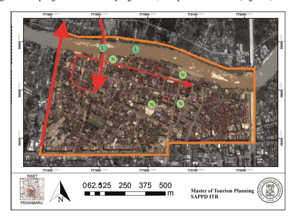
Figure 3. Elements Shaping The Image of The Riverfront Tourism Area
3. Theme
Due to the location and activities, the proper theme of the development in the tourism area is urban cultural heritage riverfront, with the following explanation:
• Urban describes the administrative region of the tourism area in Pekanbaru.
- Cultural heritage illustrates the cultural legacy in the tourism area. The cultural heritage consists of natural heritage, i.e. the Siak River. The measurable heritage includes historic buildings in study location such as mosques, tombs, and historical buildings. Meanwhile, the immeasurable heritage includes long-standing traditions such as Petang Megang, Malay art, as well as hereditary abilities such as weaving and cooking distinctive Malay cuisine.
- Riverfront describes the main theme of the area located at the riverbank of Siak River.
4. Geographical Factors
The Siak River is one of the deepest and longest rivers in Indonesia with an average depth of 20 - 30 meters and a length from upstream to downstream reaching 300 km. The land slope in this area, such as in most of Pekanbaru, in general is 0 - 2% which is considered flat and suitable for urban development. The elevation is about 5 - 10 MASL and can be classified as lowland. The soil type is alluvial which is suitable for light and medium activities. However, this type of soil is impermeable, causing slow water absorption. Looking at the regional climate, the average air temperature can reach maxima of 31.90 C - 35.10 C and minima of 23.10 C - 24.20 C. This temperature can be higher at certain times, especially with increased cases of forest fires in the past few years. This condition requires a great addition of vegetation to provide a cooler atmosphere in the tourism area such as groundcover and wood, namely mahogany (Swietenia sp) and rain trees (Samanea saman).
5. Authenticity
The authenticity of the area can be seen from two points of view, namely object-related authenticity and activity-related authenticity. Object-related, the Siak River as a natural object with a status as the deepest river in Indonesia. Its authenticity lies in its physical aspect. The community, tourists, and visitors, in general, enjoy the Siak River for its scenery (visual). The authenticity of this area can also be felt from the presence of Malay villages around the river with characteristic Malay traditional stilt houses, local community activities such as fishing and swimming in the river, as well as indigenous cultures associated with the river such as Petang Megang.
Meanwhile, the activity-related authenticity is shown by the experiences of tourists while they are in the tourism area, i.e. comfort and serenity because of the process of 'enjoying' the scenery of the Siak River. This experience would be contrary when tourists and visitors are headed for the attraction of the city, where the experience felt is liveliness with dominant activities related to trade and commerce.
6. Accessibility
Accessibility can be measured from elements such as infrastructure in the form of transport networks and facilities used as transportation facilities (Ellis 1997, in Farida, 2013).
• Road Network
The existing road network in the riverfront tourism area consists of arterial, collector, and neighborhood roads. The roads have been paved, but are not yet equipped with road facilities such as sidewalks, streetlights, and direction signs (Figure 4-5).
• Transportation Facilities
Transportation facilities include personal and public facilities. Public transportation includes the Trans Pekanbaru Bus that has been provided by the city government. However, there is no direct route yet to the Siak riverside.
Figure 4. Local Road Conditions in The Riverfront Tourism Area
Figure 5. Road Network of The Riverfront Tourism Area
7. Public Perception
Based on the questionnaires that were distributed to the community affected by the development of the riverfront tourism area in Pekanbaru, 100% of the community agrees with the plan. However, only 96% is willing to be involved due to their profession that is not related to the plan or due to ignorance about how they can be involved. As for respondents that agree, their involvement includes trade, maintaining hygiene and safety standards, becoming a tour guide, providing parking services, as well as providing homestay facilities.
Meanwhile, the community can experience positive and negative impacts. The positive impact people expect is additional income that can improve the welfare of the local community. Meanwhile, the negative impacts people fear are the cleanliness of the river being affected and the impact of bad culture entering the region, for example, a large number of young people dating around the park which they fear can affect the development of small children in the area. This prompts a great need for surveillance by the local community.
8. Management
Management in the area involves local management of the riverfront tourism area comprising the Tourism Management Unit Kampung Bandar, Marhum Pekan Micro Financial Institution, and Kampung Dalam Tourism Awareness Group (Pokdarwis). In addition, this area is also under the supervision and guidance of the Pekanbaru City Tourism Agency. Meanwhile, the private sector has not undertaken cooperation that can support the development of the tourism area.
Development Strategy for New Pekanbaru Riverfront Tourism Destination
A. Strategy of Destination Development
Revitalization of the Siak River has started with the construction of concrete slope structures in the area that will be developed into a tourist area. However, efforts to restore river conditions should be made by relocating factories located along the banks of the river to the Tenayan Raya area in accordance with the spatial plan, as well as the prohibition of untreated waste disposal into the river. In addition, the development of tourism activities are as follows.
- Crossing the river over pedestrian and cyclist bridges, with attractive designs and providing access for boats.
- Water tourism by utilizing traditional boats operated by local communities, as a form of community empowerment, either with or without machine power.
- The floating culinary market located at the former port of PT Pelindo. This market will become a new icon of the tourism area with the arrangement of merchant boats at the riverbank while the customers are on the land. This is to avoid boat traffic congestion on the river.
- Extra activities at the Waterfront Park as a Malay culinary center and routine festival which can be organized on a small stage.
- The addition of activities at Tuan Kadi Heritage House by adding books or historic objects.
- The arrangement of the Malay village and development of homestay for traditional types of accommodation.
- Adding green open space on the banks of the river as a new space for the city dwellers.
B. Strategy for Tourism Facility Development
- Extra entrance gates to be a marker that visitors have entered and are in a destination as well as to help direct the movement of the visitors.
- The addition of direction signs that indicate attractions (especially those not located on the main road) and service facilities such as public toilets, ship bridges, and others.
- The development of a tourism information center complete with tourist maps that can help tourists to identify the area first before enjoying the tourism activities on offer.
- The addition of interpretation boards for tourists to get to know more about the attractions visited, related to history, background, general conditions, and others.
- Added parking area by utilizing an empty area under the bridge.
C. Strategy of Developing Tourism Accessibility and Transportation
Development of accessibility in the tourism area is done by adding road equipment to improve the convenience of road users such as lighting, pedestrian walkways, park benches, garbage cans, and trees for shade. Transportation development is performed with the addition of public transportation routes directly to the main entrance of the riverfront tourism area using the Trans Pekanbaru Bus.
D. Strategy of Community Empowerment Through Tourism
Based on the questionnaire, the majority of the community chooses to engage in trade activities. However, the involvement of the community should be followed by the provision of skills training, in the form of the development of weaving products that can be used as souvenirs as well as other handicrafts. In addition, community empowerment is also done by involving the community in cultural festivals held in the area where they live. The community is not only involved as spectator but as committee, organizer, and performer. Another involvement is supervising of tourism activities in the area. This local control is important to avoid negative effects of tourism, such as cultures that are different from the local culture that may affect the younger generation in the area.
Conclusion
Urban Villages Kampung Bandar and Kampung Dalam, Senapelan Sub-district fulfill the elements to be developed as a riverfront tourism area. This area could be the start and an icon of riverfront tourism development in Pekanbaru. However, the development of new destinations requires destination development strategies that include the development of attractions, facilities, accessibility, and the empowerment of local communities through tourism activities.