
Introduction
Vertical urban development (VUD) is an urban development concept that intensifies the use of land. There are at least two criteria that can be attributed to VUD. First, the neighbourhood needs to be a combination of high-density urban development and high-intensity transit nodes like bus or train stations (Ratner and Goetz, 2013; Kamruzzaman et al., 2014). Secondly, the urban services that cater the VUD neighbourhood need to be within walking distance. Another prerequisite for successful VUD is mixed use of land parcels, which allows multiple functions to be developed within the same building, for instance, high-density residences developed on top of urban services (Ratner and Goetz, 2013). By implementing these two criteria in a VUD neighbourhood, it is expected that vehicle usage will decrease while the number of people who prefer to walk will increase.
Among various VUD concepts, transit-oriented development (TOD) is a well-known urban development concept that is currently implemented in several cities worldwide, for example in Southeast Queensland, Australia; Jakarta, Indonesia; and San Francisco, USA. A majority of existing urban studies have revealed that vertical urban development such as transit-oriented development (TOD) results in positive results for both the government and the public (Canepa, 2007; Cervero et al., 2002). The benefits of implementing TOD include transit users traveling greater distances within the neighbourhood than in the original design; increased health levels observed in TOD-surrounding communities (Canepa, 2007); reduced energy consumption and traffic volume (Nasri and Zhang, 2014). The advantages of TOD implementation in urban systems shows that combining TOD with green urbanism (e.g. urban agriculture) brings down carbon emission and energy use by 30 percent (Cervero and Sullivan, 2011). TOD also creates a substantial capitalization in retail and offices in the Santa Clara, California (Cervero et al., 2002). Another advantage of TOD for the general public community is the increase of house values and train ridership (Cervero and Murakami, 2009). TOD generates greater value than if each land use (e.g. commercial, transit nodes, residential areas, and public services) is constructed separately or alone (Duncan 2011). As exemplified above, abundant researches and implementations of TOD across the globe signify an interest of urban planners and practitioners in bringing VUD in practice and a vision of sustainable urban development into reality.
Despite implementations of VUD revealing various advantages in urban planning, the majority of urban models overlook vertical urban development. The majority of past urban models represent expansive type urban development, where new urban areas emerge in non-urban areas or at the fringe of the urban boundaries (Schwarz, Haase, and Seppelt 2010). Representing vertical urban development such as TOD in a computer model is challenging for at least two reasons. First, it challenges the current urban concepts and theories on urban development processes. Urban models rely on urban theories/concepts to develop the conceptual framework and on the assumption that the epistemology is correct and reflects the represented system in reality. Past urban models propose a simple model with factors such as distance from the city's CBD and transportation costs to explain a monocentric urban form and expansive urban development (Altmann, 1981). Monocentric and expansive urban features may have been possible in the early 1960s, when motorized transport, the population's activities and construction technology were not as abundant and complex as today (Baynes, 2009). However, in the last three decades, urban developments in many global cities, such as Shanghai in China, Singapore, and Jakarta, Indonesia, are marked by the proliferation of high-rise buildings (Cervero and Murakami, 2009; Kwon, 2015), as business offices, residences and other urban services demand more space to cater to urban activities. This vertical type of urban development impacts the structure of the city because urban services such as shopping centres, hospitals, or fire stations need to relocate based on population concentrations and activities around these high-rise buildings. As a result, developing an urban growth model that incorporates VUD entails a redefined urban land theory that synthesizes urban development in which space expanses vertically.
Secondly, incorporation of VUD in urban models poses a challenge on current modelling platforms. The representation of space in three dimensions requires a computer platform that allows all modelling elements (e.g. input, process, output, and visualization) to include threedimensional (3-D) space definition. For example, the elevation of the landscape and height of buildings need to be embedded as 3-D attributes in the model and visualized in the output panel. For the interaction between space and agents (e.g. residents), the movement of the agents needs to consider a 3-D space (i.e. movement along the z-axis as well as along the x- and y-axis). While most modelling platforms have limitations in representing 3-D space, a representation of 3-D urban models can be developed in NetLogo (Wilensky, 1999). Although the most recent version of NetLogo 3-D (version 6) can only simulate simple modelling rules, it allows urban researchers to explore dynamic changes in agent behavior in 3-D space.
The aim of this research was to investigate the influence of VUD on resident movement through an agent-based model (ABM) approach. ABM is a computer tool that has the capability to simultaneously represent individual agent decisions and interactions that give rise to macro-level patterns at discrete time steps (Grimm and Railsback 2005; Auchincloss and Diez Roux 2008). Generally, three separate modules are used: agents, space (or environment), and interaction. ABM is a dynamic modelling approach that unlike static urban modelling approach, it can simulate changes both in spatial elements and in human attributes simultaneously. ABM is best suited for the current case study as it has the capacity to represent dynamic movement of agents in 3-D space and also allows changes of model parameter values to be recorded during simulation. Hence, unlike preceding studies (Lo Feudo, 2014; Rodier, Johnston, and Abraham, 2002), which used a static modelling approach (i.e. a single model output at the final simulation run), modelling with ABM offers a stream of images during simulation (i.e. from the start to the end of the simulation). Furthermore, all information generated during simulation can be recorded, visualized, and analyzed. These dynamic features of ABM are demonstrated in Badland et al. (2013), who investigated the walkability of agents (i.e. people) along a street network. They showed that the street network influences the walkability level and thus is crucial for policy makers in carefully designing street networks. In brief, research developed within the ABM framework allows microscale assessment and fine-grained identification of urban processes, in this case the walkability of residents in a built environment (Wahyudi and Liu, 2015). The expected contribution of this work is to enable urban planners to better understand the quantitative interactions of resident movement within the high-rise buildings while providing a modelling framework for the development of more advanced agent-based models.
Methods
Model components
There are three modules in the model, each of which represent attributes of agents, space, and the interaction between agents and space.
1. Agent module
The agent module represents residents who have the ability to move around the city. Agents initially stand at coordinate 0, 0, 0 (south corner of non-urban land cover). They then move according to the following pseudo-code:
FIND voxel within three cell distance AND
   voxel with non-empty land cover,
  THEN move to one of the selected voxels
The movement rule allows the agents to spend part of their walking time in and around a building when there is a high-rise building in the vicinity. It also limits the agents' movements to empty voxels, which otherwise would create flying-like movement of agents.
2. Space module
The study area designed for the model is fictitious. Space is represented as voxels in a threedimensional grid that carries information such as type of land cover (i.e. non-urban, urban area, and building height) and records the number of agents that visited each voxel. The space module is 33 by 33 by 33 voxels. The building lies in the middle of a land parcel covering a 10 by 10 voxels. The user sets the height of the building at the beginning of the simulation.
3. Interaction module
A simple interaction module designed for the model recorded the number of visits by agents to each voxel. No limit was set on how many times the same agent can visit a voxel. Thus, a voxel could be visited repeatedly by the same agent.
Simulation steps
The model was implemented in NetLogo. Figure 1 shows its interface (Wilensky, 1999). The simulation starts with the user selecting the height of the building and the number of agents. Then, the simulation runs as indicated by the agents moving along non-build up areas as well as inside the building. The movement of the agents is recorded by the voxels. In this research, 10 agents were used. The left panel in Figure 2 shows the land cover and height of the building at the initial state. Three scenarios according to building height were simulated: (i) no high-rise building, (ii) five-storey building, and (iii) ten-storey building. At the end of the simulation (i.e. after 500 time steps), the output revealed the amount of agents' movements in the three scenarios.
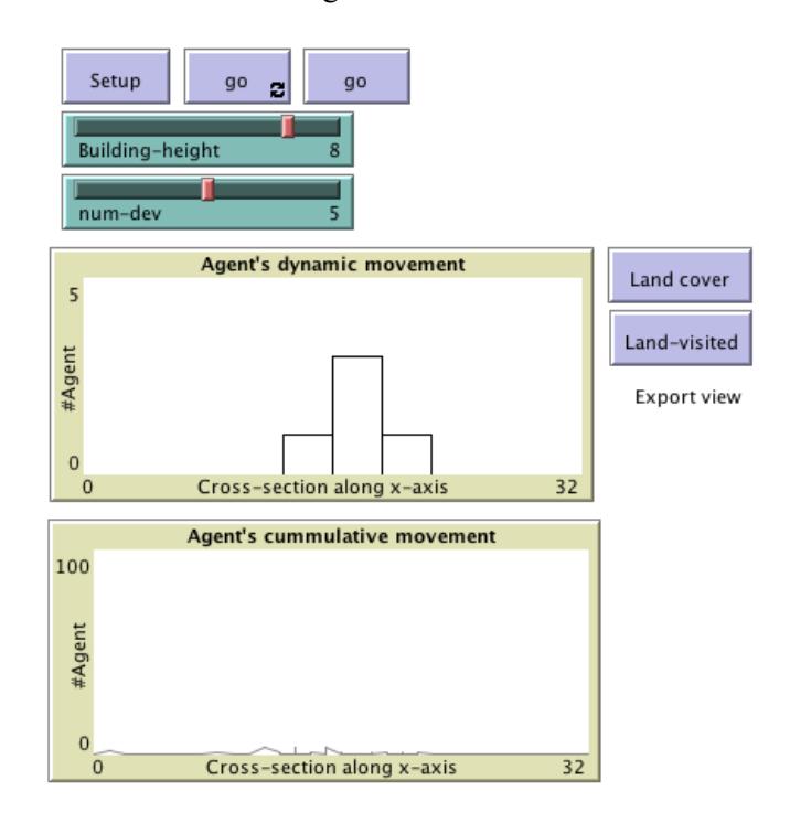
Figure 1. Interface of the model as implemented in Netlogo.
Results
Representing the visiting frequency of agents for each voxel, Figure 2 reveals a dissimilar pattern across the three scenarios. The brighter colour intensity degrades from the no high-rise building scenario (d), to the five storey building scenario (e), and finally to the darker colours in the 10 storey building scenario (f). Looking into the agents' movements in the non built-up land area
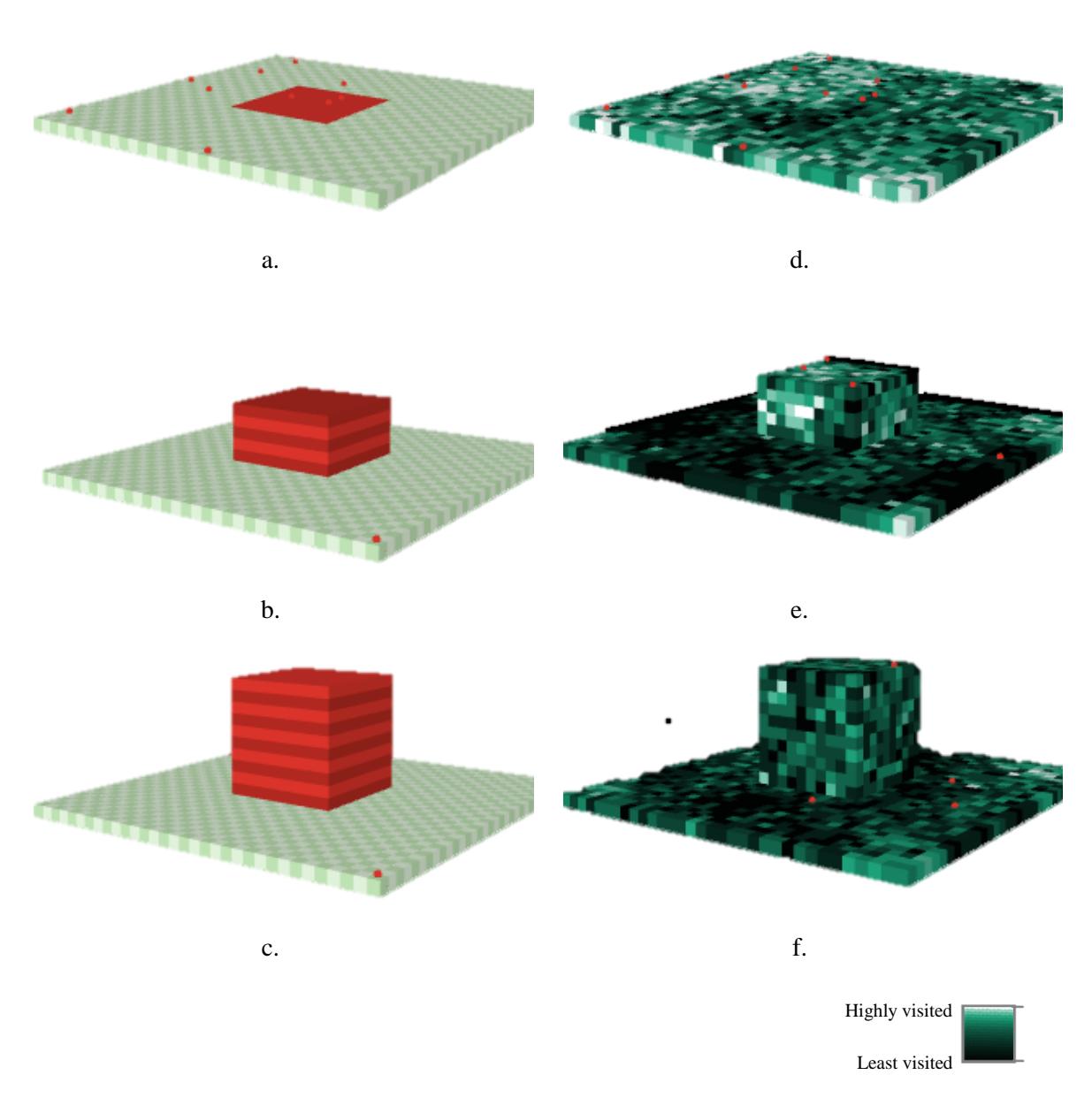
Figure 2. Non-urban land cover at the initial state represented by green voxels and urban area with elevated building represented by red voxels for: no high rise building scenario (a), 5-storey building scenario (b), and 10-storey building scenario (c). Corresponding agent movement frequency as recorded at every voxel for: no-high-rise building scenario (d), 5-storey scenario (e), and 10-storey building scenario (f).
(green voxels), the higher colour intensity (brighter) in the no high-rise building scenario than in the 10-storey building scenario indicates a change in the agents' movements. Initially they roam around no-building land and are then pulled toward the building
Measuring the walking distance of the agents on land, Figure 3 suggests that the agents roam more on land when there is no high-rise building (a), while when there is a high-rise building they walk less on the surrounding land (c).
Discussions and Conclusions
This research investigated vertical-urban development by simulating building height and analyzing its impact on resident movement around the area. By implementing a dynamic model in the form of an agent-based model, the model brings insight into the relationship between the spatial (in this case, the height of the building) and the human dimension (the residents' movement preferences). Although the simulation result seems intuitive with the high-rise buildings generating more resident movements around and within the buildings, the ABM reveals a dynamic process. Unlike traditional mental models or static models, see for example (Wahyudi et al., 2009), ABM allows us to extract values of model parameters during the simulation run, which gives the possibility to get quantitative results that show the dynamics of pedestrian movement in walkable areas during the simulation run. The potential contribution of this early version of the model is two-fold. Firstly, being able to simulate and explore existing spatial theories in combination with theories from social science (e.g. on human behavior). An example is the opportunity to explore Schelling's residential segregation theory in 3D space. Secondly, the current model can be used to test proposed urban policies. For example, with a similar amount of floor space, the user may compare the impacts of vertical and horizontal development on socioeconomic changes of the neighbourhood. Furthermore, the current version of the model allows urban practitioners to understand when a particular policy (e.g. height-floor building ratio) is to be implemented in a certain region and the impacts on the human dimension.
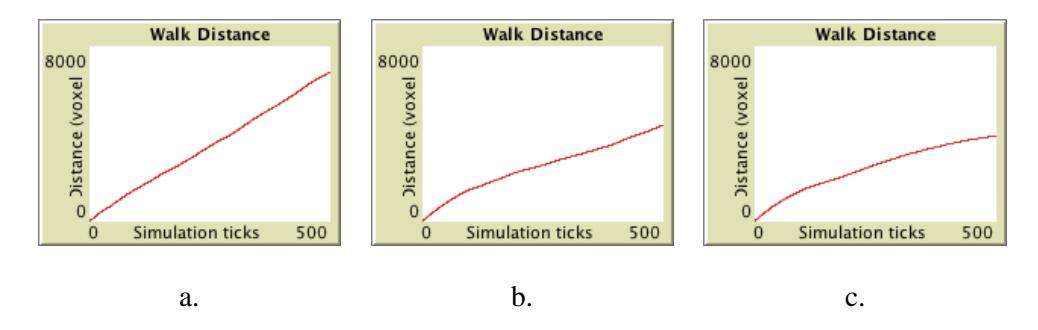
Figure 3. Change of walking distance as measured from the centre of the landscape for no-highrise building scenario (a), 5-storeybuilding scenario (b), and 10-storey building scenario (c).
The limitations of the current model are obvious. Two crucial limitations that will be implemented in future development of the model are: first, the absence of agent movement along lines such as a road network. In the current model, agents roam according to a set of pseudo codes. Freeroaming activity assumes that each voxel is equally accessible without the presence of buildings or infrastructure that may hinder agent movement. In reality, the movement of agents (residents) is restricted to designated spaces such as pathways or roads. In the further development of the model, agent movement along particular lines such as roads will be taken into account. Secondly, the agents have homogeneous characteristics, where differences according to social, economic, or demographic circumstances are overlooked. It is known that socio-economic factors influence
human locational preferences and the shape of urban neighbourhoods (Wahyudi and Liu, 2013). Implementing heterogeneous residents based on their socio-economic characteristics, such as age, health, or family structure, may reveal better insight into building-height preferences as observed from particular groups of agents. Distinction of types of land use may also be pursued in the next version of the model. Discerning land use for each building and the surrounding neighbourhood could potentially reveal a heatmap that identifies the locus of residents' activities in the area, which may reveal early indications that vertical urban development is needed in that particular area. Information from the simulation model can provide evidence for urban planners to better design the urban boundaries or building envelopes.
Acknowledgement
An earlier draft of this article was presented at "The 4th Planocosmo International Conference", Bandung, 2-4 April 2018.