
Introduction
There is a need to augment urbanisation research centred on Europe, North America and selected disadvantaged mega-cities with analyses from the developing and developed regions of Asia and the broader Pacific Rim (Gross et al., 2014). This is particularly so in the context of managing peri-urban growth and development through institutional mechanisms such as land-use planning. Urban sprawl, which can lead to significant social and economic disparities and the loss of important landscape values, typically requires management that traverses traditional administrative boundaries. Regional approaches, through land-use planning, can provide governance processes that control and distribute growth across a region, not just one jurisdiction, and facilitate the timely provision of community infrastructure and economic opportunities.
This case study aimed to synthesise and discuss the regional land-use planning approach being applied in South East Queensland (SEQ), Australia (Figure 1) to manage the region's population and urban growth. The proposition that regional, spatial land-use planning featuring strategic urban containment and consolidation can successfully manage urban and population growth while maintaining key peri-urban landscape values was examined. The research objectives comprised:
- a) briefly contextualise and conceptualise urbanisation and regional planning in terms of comparative Asian and Australian experiences
- b) outline the key principles and elements of South East Queensland's current regional plan, emphasising its growth management ('Grow') theme;
- c) identify the impact of regional planning on contemporary regional landscape development in South East Queensland;
- d) report community and professional evaluations of regional planning efficacy; and
- e) identify some specific issues concerning planning approach and execution.
This paper is based on a critical analysis of policy documents, a review of secondary literature and the authors' lived experiences in the region. As part of the research methodology, a thematic content analysis of the South East Queensland's regional plan was executed, aimed at delineating and describing the key planning devices being adopted to effect the strategic, spatial distribution of growth and development. In addition to the urban landscape, particular attention was afforded to the management of transformation in the region's peri-urban landscapes.
Following a brief discussion of the issues underpinning the management of urban growth in Australia and Asia, this paper details the approach and mechanisms of regional planning in South East Queensland aimed at strategic growth and development control. The landscape outcomes of such regional planning over the past two decades are subsequently outlined and the efficacy of the approach critically examined from both community and professional viewpoints. From this process, a number of key challenges are identified concerning peri-urban region recognition, plan integration with disaster management, growth management of master planned communities in peri-urban spaces and plan evaluation.
Urban Growth and Regional Planning in Australia and Asia
Comparing urbanisation experiences between places is always difficult due to the complexities and contrasts of the social, economic, institutional and political systems that underpin the process (Gross et al., 2014). There are significant risks in inappropriately generalising and applying local, case-specific concepts and findings. Nevertheless, sharing knowledge is a means by which to reveal and highlight the similarities and differences in urbanisation experiences between places and hence provide a catalyst for deeper, more lateral investigation and comprehension of individual cases (Gross et al., 2014).
Australia is one of the most highly urbanised countries in the world, featuring an overall low population density and a coastal orientation of settlement. Historically, Australian settlement occurred in areas of highly 'viable and versatile' agricultural lands, reflecting strong productionist values. Peri-urban regions today still have an important role in agriculture, along with their lifestyle and amenity values (Kennedy et al., 2016).
Suburbanisation, driving urban sprawl, is a key process in Australian cities. The response to pressures of urban population growth has traditionally been the expansion of urban development into greenfield sites resulting in city forms with a central business district (CBD) surrounded by widespread, relatively low-density suburban residential land use. These areas are supported by urban infrastructure and nodes of commercial, service and industrial activity (Kennedy et al., 2016). Brisbane broadly fits this form.
Beyond the urban limits of Brisbane, peri-urban development is a significant geographical manifestation of population and urban growth in South East Queensland. Its contemporary drivers and forms both compare and contrast with those of the broader Asian region. As is typically the case in Asia and globally, peri-urban South East Queensland is characterised by growing populations occupying heterogeneous, commonly fragmented landscapes of mixed agricultural, economic/industrial, residential, natural and protected land uses. It is an area of transformation where stakeholders can express diverse, conflicting values and priorities (Low Choy, 2008; Wardell-Johnson, 2016; Slade & Wardell-Johnson, 2016).
In contrast to many Asian experiences (notably developing Asia), however, peri-urban South East Queensland has not been principally transformed by pronounced influxes (sometimes state-led) of foreign investment, export-oriented manufacturing and industrial development (Webster et al., 2014; Legates & Hudalah, 2014). Furthermore, the displacement of people and augmentation of disparity (Hudalah et al., 2007), while occurring (Randolph & Tice, 2014), are arguably not as pronounced in South East Queensland as they are in Asia and elsewhere. These differences are variously attributable to complex, region-specific social, economic and governance factors.
Several drivers of counter-urbanisation, fueling the urban encroachment on peri-urban regions, have been identified for Australia and are potentially relevant generally. These include local cultural aspirations and economic drivers such as: housing affordability; accessibility to regional employment and infrastructure; and amenity – the latter driven by 'sea change' and 'tree change' motivations (Kennedy et al., 2016; Butt et al., 2016; Butt & Fish, 2016). An Australian cultural persuasion to perceive greater livability away from city centres has not been historically shared in Asian regions, although this now appears to be changing with the advent of outer-urban residential developments and increasing promotion of amenity and lifestyle (Webster et al., 2014; Hudalah et al., 2007; Smith, 2014).
Given the pressures, conflicts and transformations occurring in both urban and associated periurban landscapes, advocates argue for an encompassing, regional approach to urban and growth management (Low Choy, 2008; Webster et al., 2014; Legates & Hudalah, 2014; Hudalah et al., 2007; Buxton et al., 2016).
Regional Planning
In urban planning and growth management, capturing both urban and peri-urban components demands a coordinated, regional-scale planning approach. Many local factors, however, ultimately determine the adoption, approaches and efficacy of regional planning. In the broad Asian context, common barriers and constraints can be identified from past experiences. These include the legacy of unplanned or poorly planned land use, colonial legacies, tenure regimes and uncoordinated development (notably in relation to infrastructure provision) in addition to fragmented and/or deficient governance for plan implementation, enforcement and monitoring (Webster et al., 2014; Legates & Hudalah, 2014; Hudalah et al,, 2007; Smith, 2014). In the case of the latter, the extension of urbanisation beyond the historical administrative boundaries of cities is often a barrier to planning coordination, although the extensive municipal boundaries in China mark exceptions (Legates & Hudalah, 2014). Nevertheless, the need for robust urban planning, including regional planning, is appreciated and is being effected with increasing success, underpinned by increasingly robust planning concepts and frameworks (Legates & Hudalah, 2014).
In Australia, there has not been a strong tradition of regional planning at any level, or a propensity to engage strategic visions, particularly in the case of peri-urban landscapes (Buxton et al., 2016; McFarland, 2016). It is further suggested that the prevalence of a 'neo-liberal', economic rationalist trajectory, with its emphasis on economic development through population growth and urban expansion, administrative efficiency, entrepreneurialism and economic freedom, inhibits regional Australian planning (McFarland, 2016). The initiatives in South East Queensland can therefore be viewed as pioneering in this space.
A Framework for Regional Planning
The core of South East Queensland's regional planning approach for growth management is conceptually based on the urban containment paradigm. This paradigm promotes the use of spatial urban-development boundaries within which urbanisation is contained, with growth being absorbed through urban consolidation and densification within the urban 'footprint'. By limiting outward urban expansion (i.e. urban sprawl), proponents argue that this urban morphology can reduce infrastructure costs, lessen car dependency, reduce landscape fragmentation, refresh cities and conserve agricultural and natural lands (Angel et al., 2011). Early application of this approach is reflected by the establishment of green belts to contain development in London and Seoul during last century (Angel et al., 2011).
Although the urban containment paradigm has been widely accepted and applied, risks include inflation of land prices (and hence house prices and rents) driven by scarcity, should policies not provide for adequate supply (Angel et al., 2011). It is further argued that sustainable, equitable urban containment may be less appropriate in developing countries, where sprawl is difficult to contain and infrastructure is lacking to support higher urban densities. This can be variously due to high growth, resource access and governance realities. Alternatively, a modified paradigm is suggested that encourages more realistic projections of land needs, consequent relaxation of development limits, protection of open space and coordinated infrastructure development (notably road network development to facilitate public transit).
In the Australian and Asian regions, there appears to be an emerging, broad consensus across geographies regarding the key elements of viable regional planning in urbanising growth areas. Synthesised from a selection of regional investigations and case studies (Low Choy, 2008; Webster et al., 2014; Legates & Hudalah, 2014; Hudalah et al., 2007; Buxton et al., 2016), the key elements include:
- 1) Robust, integrated governance supporting regional spatial and sectoral policy integration;
- 2) Interpreting the region as an integrated landscape system;
- 3) Controlling the spatial extent of urban expansion (e.g. establish urban boundaries, green belts);
- 4) Protecting agricultural production and natural landscapes;
- 5) Strategically developing and locating commercial and industrial hubs and key regional infrastructure (e.g. transport);
- 6) Considering social, economic and environmental elements/services to support a sustainable region.
Supporting cross-sectoral, collaborative and flexible planning approaches, and establishing ongoing systems of collaboration and monitoring.
Following a background brief, South East Queensland's adoption of such elements to establish its regional planning approach will be outlined and critically discussed in the following sections.
South East Queensland (SEQ) Case Study Background
Brisbane, the state capital of Queensland, Australia, is the urban focus of the growing South East Queensland region. It is a developed, coastal, subtropical city sited on plain land backed by low hills. The population of Brisbane's large local government area is approaching 1.2 million people and has grown over recent years at about 1.6% per annum. Brisbane's metropolitan area is characterised by extensive urban and suburban development featuring a low-medium density suburban residential matrix that contains local nodes of higher-density commercial, industrial and/or government activity. The CBD still dominates the urban form and function, linked to the suburbs by a radially patterned transport network.
Brisbane itself is surrounded by growing regional centres, comprising Ipswich and Toowoomba to the west, the Gold Coast (Southport – Coolangatta) to the south and the Sunshine Coast (Caloundra-Noosa) to the north (Figure 1). Urban development over recent decades has featured the gradual convergence of these urban localities towards an elongated, north-south oriented urban zone extending some 200 km and a developing east-west lobe extending to 130 km. This sprawl has encroached on land previously used for agriculture, forestry and even extractive industries (e.g. coal mining at Ipswich, west of Brisbane). This development has typically maintained low-medium urban densities, providing relatively low-cost housing opportunities, but presented challenges to infrastructure provision and access to employment and services.
As described previously, much of the region yet to be urbanised can be conceptualised as periurban. This area is subdivided and fragmented, as evidenced by the high number of small lot sizes within non-urban settings. These properties of 1-5 hectares are larger than suburban residential blocks but too small for economically viable, traditionally structured agricultural uses (Low Choy, 2008). Agriculture, however, remains an important landscape element in evolving systems, including horticultural production and pastoral enterprises on relatively small lots (Slade & Wardell-Johnson, 2016). Although the number of people engaged in agriculture (even while inmigration has been significant) has decreased, the value of agricultural production in the area increased between 2006/06 and 2010/11, underlining the continued significance of this industry to the area (Slade & Wardell-Johnson, 2016). There has been considerable peri-urban growth due to the expansion of suburban-estate and rural-residential settlements associated with the network of towns in the area and the advent of larger masterplanned communities. The overall spatial form of peri-urbanisation is significantly influenced by growth corridors along key transport infrastructure and growth associated with the coastal urban centres in particular (Low Choy, 2008).
South East Queensland's administrative governance comprises a collective of twelve (12) local government areas that broadly define the region as extending north to Noosa (Sunshine coast), south to the New South Wales border and west to Toowoomba (Figure 1). Each of the twelve local councils operates an independent local government and has prime responsibility under Queensland's land-use planning framework to produce and execute local planning schemes that are consistent with state-level legislation and set priorities (Queensland Department of Infrastructure, Local Government and Planning, 2 2017a). Nevertheless, greater cooperation in recent years between these councils has enabled a regional approach to planning and development. A regional planning framework is now in place, consistent with state objectives, to which local governments must adhere in the development of their local schemes.
The South East Queensland Regional Plan 2017: 'ShapingSEQ'
In the 1990s, strategic, regional land-use planning was initiated for the South East Queensland region in response to growing concerns about the rate of growth and the potential loss of environmental, agricultural and cultural landscapes (Abbott, 1995). A cooperative exercise between all government levels resulted in the first Regional Framework for Growth Management (RFGM) in 1995 (known as SEQ 2001). It was not until 2005, however, that an updated regional framework became a statutory planning instrument. Periodic reviews of the plan have augmented its sophistication and detail, but the overall planning vision and spatial planning approach to contain and guide growth for sustainability have remained relatively consistent.
'ShapingSEQ - South East Queensland Regional Plan 2017', with a planning horizon of twentyfive years, is the latest iteration of the regional plan (Queensland Department of Infrastructure, Local Government and Planning, 2017b). It recently superseded the South East Regional Plan 2009-2031, which directed contemporary development (Queensland Department of Infrastructure and Planning, 2009). Plan synthesis and discussions presented in this paper are based on the latest 2017 regional plan (Queensland Department of Infrastructure, Local Government and Planning, 2017b).
South East Queensland's regional planning is premised on controlling the spatial distribution of expected population growth and urbanisation through strategic land-use planning. Continuing outward expansion of Brisbane's urban fabric is deemed undesirable as it poses risks to social and environmental landscapes that will likely manifest in deteriorating long-term sustainability and liveability. Regional growth is currently projected to be in the order of 75,000 new residents per year resulting in 30,000 new dwellings. The total population is expected to rise from 3.5 million
2 Following a State Government restructuring in late 2017, planning responsibilities were assumed by a new State Department: Department of State Development, Manufacturing, Infrastructure and Planning.
to 5.3 million over the next 25 years (Queensland Department of Infrastructure, Local Government and Planning, 2017b). This may appear moderate compared to other global growth areas but is significant in the Australian context. The preservation of amenity, high standards of living and the environment are highly valued in the region.
The regional plan envisions an outcome that is characterised by a compact urban structure of wellplanned, liveable and sustainable communities that are supported by a network of accessible and convenient centres. Transit corridors link residential areas to employment locations (Queensland Department of Infrastructure, Local Government and Planning, 2017b). Achievement of this outcome is buttressed by a range of plan elements and strategies under the themes of 'Grow', 'Prosper', 'Connect', 'Sustain' and 'Live'. In summary, they promote:
- 1) Increasing urban densities through contained, compact development and re-development;
- 2) Sequenced, coordinated development of new areas (notably infrastructure provision);
- 3) Strategic use of housing design and mixed dwelling types;
- 4) Support for rural town and village development to accommodate growth and manage fragmentation;
- 5) Clustered and networked hierarchy of economic development to generate income and employment region-wide;
- 6) Continuing support for rural production;
- 7) Efficient, active, connected, coordinated and prioritised transport systems and regional networks;
- 8) Strategic protection of the environment, biodiversity, regional natural landscapes, natural resources (e.g. water) and ecosystem services;
- 9) Planning and design for social equity and wellness;
- 10) Promotion of good planning and design to compliment local landscapes, character, liveability, sustainability and resilience, and;
- 11) Recognition of the influence of global megatrends.
Importantly, as a statutory document, the plan takes precedence over most other planning instruments and its regulatory provisions must be taken into account in state and local planning schemes and development processes, including the prioritisation of infrastructure development. Therefore, the plan represents a genuine attempt to achieve both horizontal and vertical planning integration.
Emphasising the 'Grow' theme in this paper, the regional plan spatially delimits three regional land-use areas that define the desired regional growth pattern: the Urban Footprint; the Rural Living Area; and the Regional Landscape and Rural Production Area (Figure 1). These are supplemented with Development and Potential Future Growth Areas. Within each there are specific landscape visions linked to enabling controls on settlement and development. Although the plan does not specifically define a peri-urban region, which is arguably a flaw, peri-urban landscapes can be broadly aligned to the Rural Living Area and the Regional Landscape and Rural Production Area.
In summary, these land-use areas, with their respective planning controls, seek to direct the spatial pattern of urban growth within the overarching paradigm of urban containment. Foremost, growth is concentrated within the Urban Footprint that surrounds the existing urban landscape through mechanisms promoting densification and limited expansion. In peri-urban areas, development is concentrated around existing local towns. Overall, this approach is deduced to limit land fragmentation and arrest inappropriate, haphazard development (for example extensive industrial
development) in peri-urban landscapes in order to maintain their characteristic land-use diversity, including agriculture use.
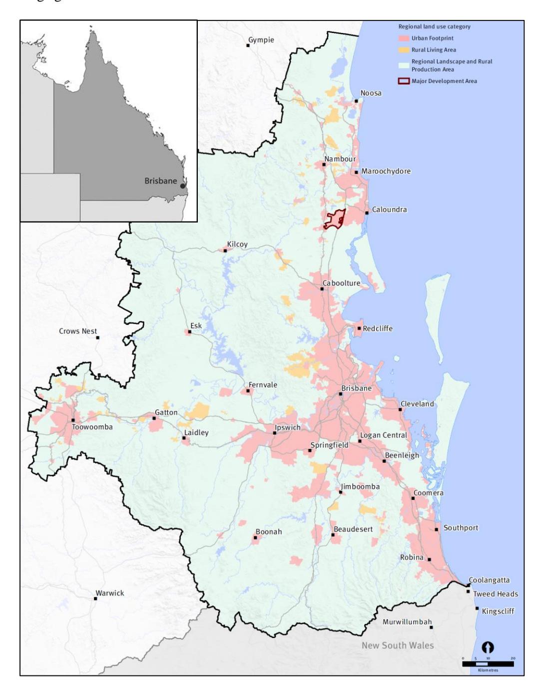
Figure 1. The SEQ Urban Footprint, Rural Living Area, Regional Landscape, Rural Production Area and Major Development Area as defined in SEQ's Regional Plan 2017. 3
3 © The State of Queensland, August 2017. Published by the Department of Infrastructure, Local Government and Planning, 1 William Street, Brisbane Qld 4000, Australia. Reproduced under the Creative Commons CC BY 4.0 Australia licence. This map is not intended for reference to specific parcels of land and is to be treated as indicative only
The Urban Footprint
The Urban Footprint includes about 14 per cent of the region, defining the current urban settlement and the boundary within which future urbanisation can take place and is prioritised. There is, however, recognition that not all land within the broad Urban Footprint is suitable for urban development due to, for example, environmental values, resource values or hazard risks. Discretion is left to local planning and/or other state legislation in such cases. Open urban, green and recreational spaces are also acknowledged as key components of the urban landscape.
Development principles for this area clearly advocate majority compact and consolidating (e.g. infill) settlement forms (Figure 2a). Ongoing, the plan's principles prioritise consistency in the boundaries of the Urban Footprint (favouring increasing capacity over boundary expansion), but still leave the opportunity to expand the Urban Footprint in specific circumstances. Local government planning schemes are expected to maintain a supply of appropriately zoned and serviceable land for at least 15 years of urban development in order to meet demand while protecting land and housing affordability.
Rural Living Area (RLA)
The current land use here features larger-lot (1-5 hectares) rural residential development, covering a comparatively small 1.7 per cent of South East Queensland. The regional plan aims to consolidate rural residential development in suitable locations, i.e. areas currently used or designated for that use in planning schemes (Figure 2b). The aim is to protect productive agricultural land, green buffer zones and land of natural significance from further rural residential development, except within the bounds of existing towns and villages. The plan is cognisant of reducing land-use conflicts and ensuring access of such communities, stating a range of planning principles for new developments, which include: requiring reasonable access to employment; infrastructure and services; avoiding conflicts with rural uses and not compromising environmental or biodiversity values.
Regional Landscape and Rural Production Area (RLRPA)
Covering about 84 per cent of South East Queensland, present land uses include a heterogeneous, fragmented mosaic of rural towns and villages; low-density rural settlement; agriculture and other rural economic activity; natural environmental resources; cultural landscapes; recreational landscapes and activities relating to 'lifestyle' decisions. These are connected to the urban areas through the movement of people and/or goods, other cultural and economic interactions and/or the provision of ecosystem services.
The primary aims of regulatory planning provisions for this area are the limitation of further fragmentation of land holdings and the restriction of various forms of urban activity in order to maintain and manage the landscape and halt urban encroachment. The continued development and economic growth of rural production and landscapes is explicitly supported (Figure 2c), as is the protection of natural assets and landscapes. Formal Priority Agricultural Areas are designated, protecting production from urban and industrial development pressures. Overall, diverse and sustainable rural landscapes are sought with rural communities building on their strategic advantages; adapting for profitability and sustainability; engaging in intensification, diversification and value adding; and planning local rural precincts.
Successfully effecting this spatial growth framework, however, depends on strategically facilitating economic and infrastructure development, and maintaining ecosystem services, in order to maximise liveability and minimise relative disadvantage, particularly on the urban fringes. Planning contingencies for containing additional future growth are also prudent in order to limit urban sprawl resuming into the peri-urban landscape if growth expectations are exceeded, and for timeframes beyond that of the current plan. The plan response is outlined in the following sections.
Coordinated Economic and Infrastructure Planning
Complementing the spatial strategies for growth management are spatial frameworks for the strategic delivery of supporting economic development for local job and wealth creation and infrastructure, such as sustainable transport and community services. Contained, multifunctional urban communities are envisaged that locally attend to community needs, reducing commuting distances and alleviating the issues of poor accessibility to employment and services that can typify urban fringe and peri-urban landscapes.
Figure 2. Landscape illustrations of: (a) Urban Footprint, (b) Rural Living Area, (c) Regional Landscape and Rural Production Area in South East Queensland. 4 4 © The State of Queensland, August 2017. Published by the Department of Infrastructure, Local Government and Planning, 1 William Street, Brisbane Qld 4000, Australia. Reproduced under the Creative Commons CC BY 4.0 Australia licence.
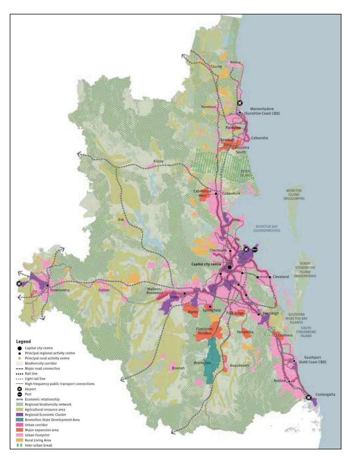
Figure 3. The envisaged SEQ landscape in 2041, based on the South East Queensland Regional Plan 2017. Key elements of the plan are illustrated.5
5 © The State of Queensland, August 2017. Published by the Department of Infrastructure, Local Government and Planning, 1 William Street, Brisbane Qld 4000, Australia. Reproduced under the Creative Commons CC BY 4.0 Australia licence. This figure is indicative and not for development assessment purposes.
The economic strategy seeks to facilitate the appropriate co-location of industries in urban growth areas to provide employment opportunities that are more easily accessible to population clusters. This is achieved by way of a designated hierarchical network of nodes that spans the region, including so-termed activity centres and regional economic clusters and areas (Figure 3).
Providing infrastructure and connectivity for these economic nodes and the community commands specific attention in the regional plan. The need to coordinate and strategically sequence infrastructure and urban development at all scales is therefore prominent in plan elements and strategies. Principles overarching activity-centre development are consistent with those of transport-oriented developments (TODs), with envisioned road and freight systems mapped and prioritisations of specifically defined transport infrastructure projects listed. Importantly, these regional plan elements are now supported by a governance framework that explicitly connects it to the state's Infrastructure Plan and Regional Transport Plans.
In both the RLRPA and the RLA, plan strategies encourage 'place-making' initiatives in rural towns and localities that enhance the regional reputation for liveability, subtropical design, economic vitality and community engagement in place-making, unlocking creativity and potential and attempting to preserve and enhance the distinctive landscape character of the peri-urban region. Such strategies, notably regarding place making and economic viability, can promote recognition and exploitation of the functional links between the peri-urban and urban landscapes within the broader regional system.
The Environment
The regional plan advocates the protection of cultural heritage and natural assets including ecosystem services and biodiversity. Land degradation and fragmentation are managed through mechanisms including the spatial designation and strategic management of protected and significant areas (ecology and amenity) and maintenance of green belts/buffers (including an inter-urban breaks and an urban greenspace network), natural corridors and significant cultural localities. Environmental buffers particularly protect and spatially define peri-urban landscapes.
Development and Potential Future Growth Areas
The regional plan specifies development areas that include Major Development and Priority Development Areas. They are a hedge against development risks, such as faster than expected growth, within the Urban Footprint. Figure 3 locates these areas under a combined category of 'major expansion areas'. Major Development Areas are large, proposed growth areas that may be called upon to absorb growth if needed, but they require progress in coordinated land use, economic and infrastructure planning and development to be viable and sustainable. For example, Beerwah East is identified as one such area between Brisbane and the Sunshine Coast (Figure 1, Figure 3). Several previously identified areas are now being developed as large-scale master planned communities. These will be discussed in a following section.
Priority Development Areas are land parcels managed from state level, by Economic Development Queensland, under specific legislation. The emphasis in these localities is on accelerated, economically oriented development within collaborative regional planning (Queensland Department of State Development, Manufacturing, Infrastructure and Planning, 2018).
Potential Future Growth Areas are located within the RLRPA and intended as a further contingency for high future urban growth. They are indicative only and are not subject to planning, investigation or promotion unless existing strategies are underperforming, in which case their designation may be defined and elevated to a Priority Development Area in future regional plans. Again, the specification of the discreet areas for future urban development supports the containment of development within the currently defined Urban Footprint and near existing settlements in the peri-urban landscape, hence discouraging the encroachment of unchecked urban sprawl and its impacts.
Figure 3 visually summarises the key elements of the 2017 Regional Plan, expressed as the envisaged landscape outcome in 2041. Although a regional view is taken, the plan provides specific planning detail at sub-regional scales – Metro, Northern, Western and Southern. This aims to assist achieving greater clarity and direction to the plan and provide a framework to facilitate the application of state-level planning interests. Specific detail at this scale is beyond the scope this paper.
Plan Implementation and Monitoring
Implementing plans effectively through appropriate governance frameworks and then monitoring their performance are regarded as key elements in planning success. Outcome delivery and plan monitoring are addressed within the regional plan document as a purposeful attempt to address and avoid the fragmentation of governance that has been observed to affect the efficacy of regional planning (Webster et al., 2014; Legates & Hudalah, 2014; Hudalah et al., 2007; Smith, 2014). Roles and responsibilities for coordinated leadership and governance are nominated, along with a supporting framework of government, committee and engagement structures, some being statutory requirements. There is clear specification of the relationships between the regional plan and other plans, programs and policies including the State Infrastructure Plan, State Planning Policy, Planning Act and Planning Regulation, and detailed frameworks for regular plan review, implementation and consultation. The new regional plan is hence part of an integrated governance framework that explicitly links planning and development at all levels to infrastructure coordination (Figure 4).
Importantly, statutory regional plans are now clearly located within Queensland's hierarchical planning system. State-level planning policy prevails over regional (and local) plans where inconsistencies emerge, while the regional plan similarly takes precedence over the local planning scheme. The fundamentally important local government planning schemes require ratification, from state level that they adequately integrate the regional plan (Queensland Department of Infrastructure, Local Government and Planning, 2017a).
The regional plan outlines an implementation program that comprises the categories of:
- 1) Delivering new growth areas
- 2) Driving future prosperity
- 3) Supporting growth
- 4) Sustainability and natural systems
- 5) Delivering better design and housing
- 6) Continuing the conversation, and
- 7) Keeping SEQ progress on track.
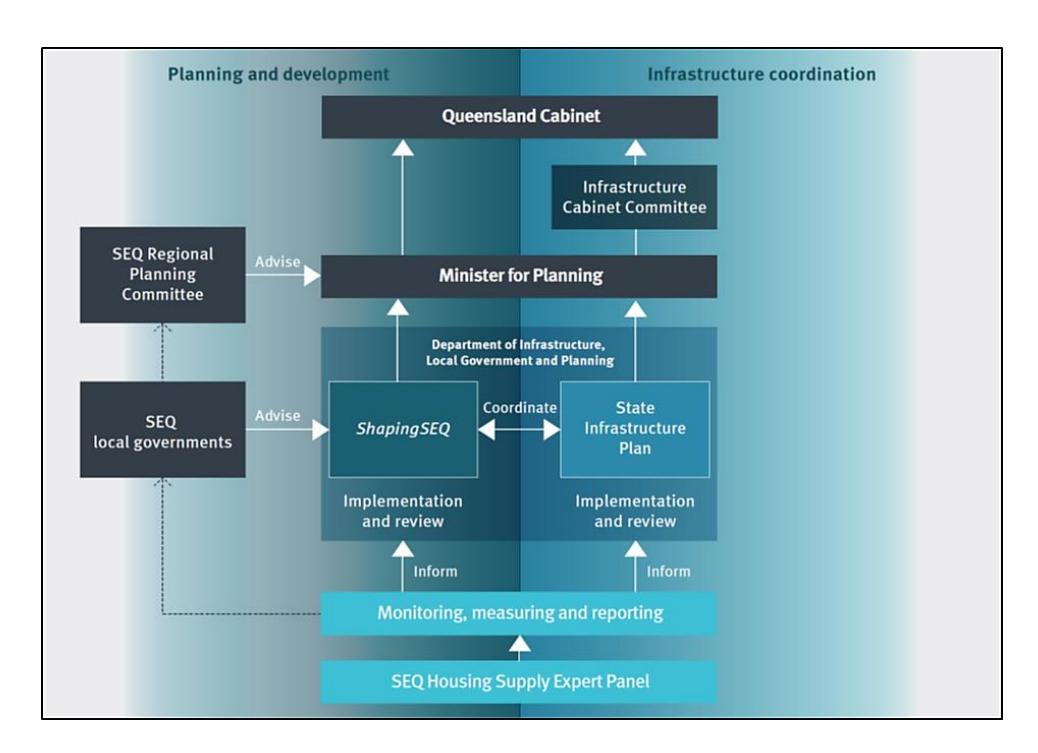
Figure 4. Governance arrangements in Queensland's coordinating planning and infrastructure. 6
Under each category, purposes are defined, for example 'unlocking underutilised Urban Footprint', under the growth delivery category. In turn, actions are recommended for each purpose, for example, investigating development constraints. Role responsibilities are hence assigned to specific government departments, authorities and external groups, with task prioritisation.
Regarding monitoring, the regional plan stipulates a framework comprising a set of key progress indicators ('measures that matter') and the SEQ Growth Monitoring Program. In the former, a small set of indicators reflect progress in each of the regional plan's five themes of 'Grow', 'Prosper', 'Connect', 'Sustain' and 'Live'. For example, under the 'Grow' theme, the progress indicators are: years of supply (indicating land supply/scarcity that affects land and house affordability); dwelling growth (monitoring urban consolidation and expansion); housing type (reflecting housing diversity); and housing density (monitoring efficient land use). For each indicator, reporting requirements are itemised, including required detail and timeframes. Significantly, indicator benchmarks are nominated against an SEQ baseline, current trend and 'SEQ's preferred future'.
The plan provides some support for achieving benchmarks. For example, there is brief guidance on urban density and design, but most responsibility for achieving practical outcomes that are consistent with both state and regional planning policies is left to local-level planning schemes. The SEQ Monitoring Program is primarily directed to analyse dwelling supply, expected land availability and employment baselines on an annual basis via robust methodology and crosssector consultation. Local government planning schemes are expected to provide appropriately zoned and serviceable land for 15 years of urban development to address potential growth and 6 © The State of Queensland, August 2017. Published by the Department of Infrastructure, Local Government and Planning, 1 William Street, Brisbane Qld 4000, Australia. Reproduced under the Creative Commons CC BY 4.0 Australia licence.
land price pressures. The regional plan itself is set for periodic review with the next scheduled for between 2022 and 2024.
Settlement, Economic and Landscape Change in Response to SEQ Regional Planning
The test for regional planning efficacy is whether its application progressively results in landscape transformation that is consistent with its visions, goals and principles. Over the time of regional planning in South East Queensland, the broad, spatial planning approach to urban growth management has been relatively consistent with that described for the 2017 Regional Plan (although there has been progress in specific strategies and coordination).
The Queensland Department of Infrastructure, Local Government and Planning identified several benchmarks and trends that support regional planning efficacy in achieving desired landscape outcomes. These include: (summarised from Queensland Department of Infrastructure, Local Government and Planning, 2016a, p. 8):
- 1) Compact settlement 2006 to 2016: "68 per cent of SEQ new dwellings were approved in the existing urban area" (p. 8)
- 2) Housing diversity since 2011: apartments and townhouses (and the like) comprised more than 50% of new dwellings approved (i.e. compact design)
- 3) Growth in high value sectors, including: "financial and insurance services (9.5%), professional, scientific and technical services (7.5%); transport postal and warehousing (7%); and construction (6%)" (p. 8)
- 4) Efficient land use 1995 to 2015: reduced median new residential lots size (from 675 m² to 475 m²)
- 5) Support for rural production and tourism 2006 to 2015: increased gross regional rural production ($1.083B AUD to $1.200B) and tourism ($5.460B AUD to $7.299B), but these reduced as a proportion of SEQ's Goss Regional Product
- 6) Integrated land use and transport 2004 to 2011: increased car usage, but also increased public transport journeys (from 7 to 7.4%)
- 7) Improved public transport services and active transport infrastructure 2001-2011: increased the share of journey to work trips by public transport (10.4% to 12.3%), following a sharp decline in the 1980s
- 8) Protection for regional greenspace network 2006 to 2015: increasing land area of the protected greenspace network (an extra 21,300 ha of land was added)
- 9) Protection for the region's biodiversity: decreased vegetation loss in SEQ since the advent of statutory planning (from average 7700 ha per year to 3600 ha per year), "however, vegetation is still being lost every year" (p. 8), and
- 10) Affordability: level and growth of Brisbane median house price has been relatively low and steady respectively compared to other Australian state capitals.
From an urban consolidation perspective, Brisbane's urban morphology is increasingly characterised by near-CBD and suburban densification, including the establishment of TODs, suburban master planned communities and suburban re-development. Reflecting regional plans, this is occurring in a spatially structured, integrated manner through Brisbane's own local planning scheme, which specifies hierarchical nodes of higher-density development and zones of commercial and industrial activity to direct and focus densification and land-use change. This aims to strategically preserve Brisbane's distinctive suburban and natural landscape character, while addressing the wider regional growth-management goals (Brisbane City Council, 2014).
Considering peri-urban landscape transformation, expansion developments within the urban footprint are of particular interest. A contemporary feature of South East Queensland urban development is the emergence of large, outer-urban master planned communities. Their sites were typically identified in past regional plans as development/potential development areas that served the regional growth management agenda. Regional plans have previously set the Urban Footprint boundary to accommodate these developments.
The Forest Lake and Springfield developments, south-west of Brisbane, were the first large, master planned communities to emerge in the 1990s. They were developed on greenfield sites and now house 10,000 and 30,000 people respectively. Figure 5 shows the current, distinctive urban morphology of the Springfield development. North of Brisbane, the North Lakes master planned community, with a current population of 15,000, developed adjacent to the Bruce Highway and close to the Narangba commercial/industrial area.
Figure 5. The Springfield master planned community southwest of Brisbane. Source: Google Earth image ©2017 DigitalGlobe.
Among the aims of these developments was to provide diverse, affordable, well-serviced and livable communities that would help to absorb and consolidate population growth within the region. The Springfield development, for example, offers local education (up to university level) and employment and commercial precincts, and is connected to the major centres of Ipswich and Brisbane by newly developed rail infrastructure and major road networks.
South East Queensland's regional planning approach embraces the strategy of focusing regional growth into such centres. More master planned communities are currently under construction, or proposed on greenfield sites within the Urban Footprint, including developments at (see Figure 2):
- 1) Ripley Valley (southwest of Ipswich; 50,000 dwellings for a population of 120,000),
- 2) Greater Flagstone (south-east of Ipswich; 50,000 dwellings for a population of 120,000),
- 3) Yarrabilba (south of Logan; 20,000 dwellings for a population of 50,000 people, and
- 4) Caloundra South (southwest of Caloundra; 20,000 dwellings for a population of 50,000). (Queensland Department of State Development, Manufacturing, Infrastructure and Planning, 2018)
Generally, these developments attach to the existing urban fabric and extend it into the adjacent peri-urban landscape but in a compact, contained form within the Urban Footprint rather than a sprawl. In siting these master planned communities, priority is given to the ease of accessibility to essential infrastructure, services and employment. Therefore, they are typically located near key transport routes, existing urban infrastructure and either developed or developing commercial/industrial hubs that provide local employment opportunities. For example, Greater Flagstone is located adjacent to the existing Logan City and other towns/villages; on the Brisbane to Sydney rail line; and near state-promoted commercial/industrial development and other designated development areas (e.g. Bromelton) (Figure 3).
In addition to the larger master planned communities, smaller residential and rural residential developments are appearing on the urban fringes but still within the regional Urban Footprint. These smaller developments have a residential focus and rely on the existing, local urban functions to provide services and employment. Although small, they are collectively significant in extending urban land use into the peri-urban landscapes surrounding cities, smaller towns and major transport corridors, potentially in a fragmented pattern. Local planning schemes take prime responsibility for their location, design and approval, underpinning the importance of cohesive, enforced regional planning to avoid many smaller decisions compromising the regional vision.
Community Evaluation of Regional Planning Efficacy
To further assess South East Queensland's regional planning, the Queensland Department of Infrastructure, Local Government and Planning surveyed the community to elicit their perceptions and attitudes towards the region and its management (Queensland Department of Infrastructure, Local Government and Planning, 2016b). Almost 1,400 members of the public were surveyed in 2016 by way of participation in community conversations. This was followed up by further consultation aimed particularly at the development of the final 2017 SEQ regional plan (Department of Infrastructure, Local Government and Planning, 2017c7 ). Although commentary continues amongst academics and professionals regarding growth-management approaches and specific details of regional plans and local planning schemes, the community itself is in the best position to comment on planning successes, concerns and failures from their perspective. Nevertheless, the researchers highlight that the above-mentioned survey and consultation was overseen by the state government department responsible for land-use planning.
Continuing regional growth has been historically met with some trepidation by the public, possibly due to a range of factors including: previous adverse publicity concerning urban consolidation and resulting loss of residential amenity; lack of supporting infrastructure in urbanfringe growth areas; and increased traffic and environmental concerns. This survey's results, however, arguably reflect increasing public acceptance of regional growth, with respondents identifying increased infrastructure, business and job opportunities as benefits of growth. Nevertheless, the planning and form of such growth is important to the public, who desired strategic location and design of increased residential densities; access to infrastructure and transport with growth; creation of employment hubs; integration, connectivity, capacity and frequency of transport; green space retention and environmental value recognition; retention of the identities of places; and better subtropical design. Overall, high percentages of respondents reported satisfaction with living in South East Queensland and stated that their quality of life was excellent (81% and 77% respectively).
7 The community survey results reported in Queensland Department of Infrastructure, Local Government and Planning (2016b) are also reported in this publication.
Table 1 summarises changes of responses concerning resident attitudes towards growth in South East Queensland from 2010 to 2016. The increase of the acceptance of growth is quantified, but concern has grown about access to the amenity and recreational features of the beach, bushland and city, and concerns remain over employment access.
In pursuing this paper's sub-theme of peri-urban transformation, the survey results can be deconstructed into sub-regions, which allows responses from the Brisbane metropolitan area to be excluded. The remaining northern, western and southern sub-regions do not eliminate the urban landscapes of the coasts, Ipswich and Toowoomba, but they at least capture responses from the peri-urban areas and dilute the influence of Brisbane.
Table 1. Attitudes and attitude change by surveyed residents towards population growth and liveability in South East Queensland.
| (Adapted from Department of Infrastructure, Local Government and Planning, 2016b) |
|---|
| Theme | Survey Question | The 2010 response indicating 'change for the better' | The 2016 response indicating 'change for the better' | Change between period |
|---|---|---|---|---|
| Grow | Please indicate how you feel about the effect of population growth for South East Queensland | 47.4% | 55.7% | +8.3% |
| Please indicate the type of change you think long-term population growth will have in South East Queensland; for example… | ||||
| Prosper | the availability of jobs | 41.7% | 41.9% | +0.2% |
| Connect | our public transport system | 38.2% | 7.8% | +9.6% |
| Sustain | access to beaches, bushland and the city | 75.4% | 68.9% | -6.5% |
| Live | the character of housing | 37.1% | 42.8% | +5.7% |
Table 2 presents a selection of statistically significant results, focussing on overall perceptions and the 'Grow' theme. Amalgamated sub-regional survey responses (excluding the Brisbane metropolitan sub-region) are compared to the total for South East Queensland, highlighting issues relating to overall perceptions and population growth. Selections included are those more relevant to the peri-urban experience.
Respondents in the non-metropolitan sub-regions were, compared to the South East Queensland aggregate, relatively positively inclined towards access to open space, recreation, beaches, bushland, city and locally grown produce. They were more likely to consider that natural assets are being protected and that they should feel safe. The data also reflect that in the nonmetropolitan sub-regions there are relatively stronger associations between population growth in South East Queensland and hence improved opportunities to access services and protect rural industries and the environment. The key negative issue here was access to transport infrastructure.
The overall impression from the results of this government-sponsored community survey is that South East Queenslanders, including those in peri-urban landscapes, are reasonably comfortable with the approach to contemporary development and the regional-landscape form advocated (i.e. compact urban design, regional settlement and greenspace networks, infrastructure prioritisation, etc.). A continuing issue, however, is the provision of transport to the non-metropolitan areas. Although this imperative is recognised in the current regional plan, delivery of improved transport infrastructure has likely lagged in some areas.
Table 2. Community perceptions of South East Queensland's environment and liveability, excluding the Brisbane Metro (metropolitan) sub-region.
(Adapted from Department of Infrastructure, Local Government and Planning, 2016b)
Non-metropolitan sub-regions: more likely than total South East Queensland to AGREE
Overall
Easy access to open space and recreation areas Easy to get around/ travel Beaches, bushland and city are accessible Natural assets are being protected Locally grown food is readily available Good urban design Perceived as safe
Grow theme
More sporting and recreational opportunities with population growth More education options with population growth
Greater housing availability and diversity with growth
The natural environment and rural activities/production would change for the better with growth
Better public transport with growth
Better availability to entertainment options and cultural experiences
Non-metropolitan sub-regions: more likely than total South East Queensland to DISAGREE
Overall
Plenty of travel options
There are opportunities to live near public transport
Grow theme
High-density living generates more traffic congestion
The survey research reported above, managed by the Queensland government itself, was considered in developing the latest plan. There is a need, however, for further research that is independent of the planning process (and those effecting it) to critically evaluate these findings and facilitate on-going, impartial community evaluation of regional plans and their outcomes.
Regional Planning Issues and Opportunities
The recency of the latest South East Queensland Regional Plan, ShapingSEQ, means that a substantive literature of professional and academic critiques is yet to be published. Over the period of regional planning in South East Queensland, however, discussion and debate over the approach and earlier plans and drafts has been significant. Common themes included:
- 1) Environmental concerns, for example the lack of specificity of earlier plans in addressing climate change, change adaptation and the protection of ecological values and green belts (Dedekorkut et al., 2010; Burton, 2010);
- 2) Critiques of the spatial distribution, equity and economic viability of proposed activity centres and densification (Searle, 2010);
- 3) Governance fragmentation in Queensland resulting in less than desirable coordination of regional growth, economic and infrastructure planning, and the regional plan's lack of statutory power, all affecting the efficacy of earlier plan versions (Steele & Dodson, 2014; Abbott, 2012; Planning Institute of Australia, 2017; Spearrett, 2010); and
- 4) Concerns over the recognition of the regional contribution of rural areas and the efficacy of plan-outcome monitoring and review (Planning Institute of Australia, 2017).
The current regional plan has progressed several of these themes through its incorporation of global megatrends (including environmental), consideration of housing design in relation to densification and clear, detailed frameworks for integrating growth management with economic and infrastructure development (Planning Institute of Australia, 2017). Systematic, if not quantitative, approaches to monitoring and benchmarking are specified. Importantly, recent regional plans have been elevated to the status of statutory instruments requiring structured and integrated planning across localities and scales.
While evaluation of the current plan will be the subject of ongoing research, this paper briefly introduces three contemporary issues of interest: recognition of the peri-urban landscape systems, integration of disaster management into the regional plan, and the management of master planned community developments.
Recognising 'Peri-urban'
Although the term 'peri-urban' is used in the 2017 Regional Plan, it is defined only at a rudimentary level: 'The area of influence between rural and urban areas, usually located near urban areas' (Queensland Department of Infrastructure, Local Government and Planning, 2017b, p. 182). The spatial framework of the plan does not specifically delineate a 'peri-urban' region, nor is this term specifically used in defining its sub-regions for 'sub-regional directions'. Nevertheless, the plan's pivotal regional RLRPA and RLA appear to at least approximate the heterogeneous peri-urban region. Research is now detailing the complex systems, values, transformations and conflicts of peri-urban landscapes as a distinctive geographical system. More explicit recognition and demonstrated understanding of this work seems justifiable in regional planning.
Integrating Regional Planning and Disaster Management
South East Queensland has significant exposure to natural hazards, including storms, tropical cyclones, flooding, bushfires, landslides and heatwaves. Large areas within the region, including Brisbane itself, have experienced moderate-to-severe flooding within the past decade. Only in the recent past have there been significant attempts in Queensland to genuinely integrate land-use planning and disaster management, for example in the development of frameworks for integrated floodplain management (Queensland Reconstruction Authority, 2012) and the specification of state land-use planning policies that address risks for hazard exposure (Queensland Department of Infrastructure, Local Government and Planning, 2017a). For both land-use planning and disaster management, local governments take prime responsibility for local plan development and management, directed by state-level policies and plans.
The South East Queensland Regional Plan 2017 addresses natural hazard resilience under its 'Sustain' theme (Element 10: Safety). It advocates the use of risk-management planning, adaptive strategies and avoidance of high-risk exposure to hazards including floods, bushfires and landslides (the latter under its Urban Footprint and rural living principles). Under its
implementation program, flood risk is specifically identified for integrated risk management and emergency response-and-recovery management under the sustainability and natural systems category. Although relevance across all stream catchments of the region (there are 16 major catchments) is recognised and responsibilities for action nominated, there is a focus on the Brisbane river catchment and the development of a Brisbane Region Strategic Floodplain Management Plan. No such detail is forthcoming for other hazards, including bushfires. The latter may be particularly significant at urban boundaries and particularly for rural residential developments that are observed, in the peri-urban area, to be in or near relatively high bushfirerisk zones. Without further regional planning guidance, the burden of responsibility for integrating hazard/disaster management and land-use planning is devolved to the local government level, where planning and execution can be problematical due to a range of factors, including knowledge and resource constraints and stakeholder pressure (Childs et al., 2010).
Master Planned Communities
The expected continuing growth and the desire by the community and governments for diverse, affordable housing in the region both exert pressure and create demand for ongoing urban development. A significant proportion of this is likely to be accommodated by peri-urban master planned communities advanced by private developers. Although the regional plan includes contingencies for future growth within the designated urban footprint, it does not explicitly exclude the footprint's future expansion, hence potentially compromising the current vision, even if gradually. This is of particular concern in the longer term (beyond the current planning horizon) given the commercial incentives for development, the potentially significant influence of private developers on local decision-making, and governments' wishes to 'unlock' land for development in order to address affordability issues, meet benchmarks, and progress their local communities.
A further issue in this context, again related to disaster management, concerns the designation of Potential Future Growth Areas in the regional plan. Here, only 'coastal hazards' are specifically mentioned in the context of investigating Potential Future Growth Areas. Given that past designated growth areas (variously named in earlier regional plans) have evolved to accommodate development, including master planned communities, comprehensive hazard-risk assessment may be prudent even at the earliest stages of identifying localities for potential, future urban development. Hazard risks now faced by established and developing large master planned communities concerning hazard exposure, accessibility, evacuation and emergency service provision, and their management, requires further investigation.
Conclusion
The current South East Queensland Regional Plan 2017, ShapingSEQ, provides an example of an integrated regional plan and planning process that has been developed and refined over the past twenty-five years. The plan exhibits a framework of elements and strategies that are generally deemed desirable for effective and sustainable regional planning and growth management. These include:
- 1) The aim of geographically-defined urban containment and consolidation in relation to growth management.
- 2) Regional integration of governance with a clear framework that articulates relationships between policies and stakeholders and identifies goals, principles and stakeholder responsibilities in addressing these.
- 3) Infrastructure and economic development that is spatially coherent with the desired regional distribution of population/residential growth.
- 4) Protection of broader landscape values, services and amenities of natural, rural and agricultural production landscapes, through strategic spatial zoning.
- 5) A consultative planning approach.
- 6) Ongoing, prescribed evaluation, monitoring and benchmarking of growth, development forms, land supply and the Urban Footprint extent, the latter to avoid supply shocks potentially associated with urban containment policies.
- 7) Identification of future growth localities, reflecting plan flexibility and contingency buffers.
Generally, the public and professional communities have been supportive of regional planning in South East Queensland. Nevertheless, ongoing challenges are apparent in applying the integrated, regional framework. For example, lags in the provision of infrastructure (notably transport) in growth areas continues to be a publicly perceived issue that arguably reflects both management and market failures. Other issues challenge the efficacy of the planning framework itself. For example, ShapingSEQ does not directly delineate and describe the peri-urban region, hence detaching itself from embracing the current progress in conceptualising and understanding periurban landscapes. Furthermore, the growth containment strategy that aspires to protect regional landscape values and diversity is significantly dependant on the consistency of the Urban Footprint's spatial extent. The plan, however, does not explicitly guarantee that its boundary will not be modified in the future. Finally, the plan also does not take the opportunity to significantly progress the integration of land-use planning and natural hazard/disaster management to reconcile a coordinating, region-wide 'all-hazards' approach.
The recency of ShapingSEQ means that extensive critical commentary from professionals and academia on its concepts and application are still forthcoming. Continuing, independent evaluation of plan efficacy is highly desired for genuine, objective evaluation. In general, risks remain as global megatrends manifest themselves at local and regional scales, changing social, political and economic perceptions and objectives. In the longer term, these may challenge and require compromise to the current regional landscape vision and enabling strategies. Evolving public perceptions and acceptance of the urban forms envisaged is also an ongoing risk, in particular their potential intolerance of continuing urban densification within the Urban Footprint and any impacts of limiting urban sprawl on land/housing affordability. These community concerns could eventually be reflected in political responses that dilute the conviction of the contemporary regional planning strategy to manage growth through urban containment. Pressures from developers and local governments to release land (including greenfield sites) similarly may pose a risk to the strategy, including the longer-term consistency of the Urban Footprint's extent. Any expansion of the Urban Footprint and local urban development thresholds potentially impacts the peri-urban landscape.
As previously observed, the validity of applying local lessons to other contexts, notably developing Asia, is difficult. South East Queensland does, however, provide an example of an established, long-running regional planning approach. At a general level, its acceptability and reasonable success is grounded in its priority to overcome governance fragmentation through a detailed, inclusive, hierarchical regional framework that now has legal planning status. Direct integration with infrastructure and economic planning and development, supporting a contained and consolidated urban form appears to have also been critical. In the regional landscape context, diversity of land use and values are respected, preserved and enhanced, as much as possible, including cultural and environmental values and ecosystem services. The plan is now also underpinned by systematic, regular land demand/supply evaluation and monitoring. Elsewhere, local decision-makers must evaluate the practicality and potential of this overall approach for their own circumstances.
Acknowledgement
A Bond University Faculty Grant funded this research.