
Introduction
The awareness of vulnerability and risk assessment (VRA) for natural hazards and the effects of climate change is increasing. For example, at the global level, Oxfam published a practical VRA guide (Morchain & Kelsey, 2016). At the regional level, the Association of Southeast Asian Nations (ASEAN) conducts regional risk and vulnerability assessment (AHA Center, 2017) since 2014. Meanwhile, in the context of Indonesia, VRA has gained more attention since it was first formally institutionalized through Regulation No. 2/2012 on risk assessment of the Head of the National Disaster Management Agency (BNPB). One of the risk assessment products in Indonesia is a disaster risk study called InaRISK (BNPB, 2016b). InaRISK is the basis for risk management and the formulation of policies and actions for disaster risk reduction (BNPB, 2016b).
The mutual relationship between the human population and nature influences the vulnerability and risk of an area (community) in the form of the physical background and the social-political structure (Oliver-smith, 2009). According to Oliver-Smith (1999, 2004, 2009), vulnerability is a subject of political ecology because it studies human and natural interactions closely related to the political economy. Although some researchers, such as Pelling (1999), Marks (2015), Salami, von Meding, & Giggins (2017), Maes et al. (2019) have utilized the urban political ecology (UPE) framework, so far no research has been carried out in the Indonesian context. Notably, there have been no studies that discussed the vulnerability of coastal areas or communities.
The purpose of this study was to elaborate on existing VRA, primarily to discuss vulnerability more profoundly and search for a comprehensive approach in conducting VRA for Bandar Lampung. This research used UPE in reviewing VRA projects and vulnerable communities and areas. UPE views the condition of the urban environment as influenced by human-nature interaction. In this case, poor urban environmental conditions are another form of vulnerability. Also, human-nature interaction, in this case, is not only in a balanced state but also influenced by an imbalance in resources and politics in the context of urban space (Swyngedouw & Heynen, 2003). Where urban conditions are not only influenced by components within a community or region but also by external components (Oliver-Smith, 2009). Therefore, the UPE framework can be used to understand the dynamics of cities that affect vulnerability. As Marks (2015) mentioned, UPE can be useful to explain more fully how disasters are formed and occur.
To give an example of how community and area vulnerability is formed, we used kelurahan (urban villages) Kota Karang and Kangkung in the city of Bandar Lampung as the study locations (see Figure 1). The two sites are coastal areas that are considered vulnerable to earthquakes/tsunami (Bappeda, 2011; Elmhirst & Darmastuti, 2018; Lassa & Nugraha, 2015; Taylor, 2010), flood-prone (ACCCRN, 2010), and vulnerable to sea-level rise (ACCCRN, 2010). Moreover, low-lying coastal urban areas are a culmination point of social vulnerability where low human adaptation and high exposure collide (Nicholls et al., 2007). Therefore, city dynamics and the trajectory of how human settlements become more vulnerable to natural hazards and the effects of climate change cannot be captured only by technocratic risk assessment (Adger, 1996). In other words, a more comprehensive approach is needed to understand vulnerability.
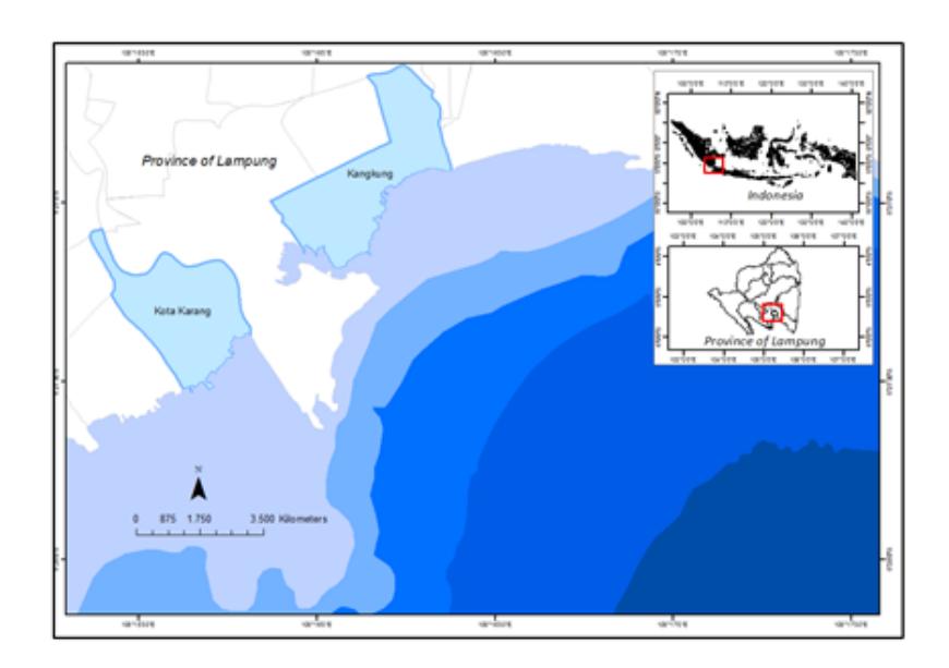
Figure 1. The map of study location.
This research used data collection through field observation, interviews, literature study, and focus group discussions (FGD) on achieving its aim. In addition, one of the authors has been involved in climate change projects in the city of Bandar Lampung since 2009. Meanwhile, interviews were conducted with ten key informants with community and government backgrounds. The literature review was carried out on more than 40 VRA documents, scientific articles related to UPE and VRA, as well as government and news reports. The FGD was carried out by participating in an FGD held by the Ministry of Agrarian Affairs and Spatial Planning/National Land Agency (KemenATR) in 2018 in the framework of a disaster risk reduction (DRR) and climate change adaptation (CAA) integration project.
This study consisted of three stages of analysis. The first stage was to review projects containing VRAs related to coastal areas in Bandar Lampung. The second stage was to elaborate on why coastal areas are considered vulnerable communities based on the literature. The third stage was to reflect on the practical problems in the coastal areas that are connected with the Bandar Lampung landscape as a metabolic system. In the third stage, the practical problems in question are the material circumstances that have the potential to produce vulnerability to communities or coastal areas. At each of these stages, UPE was used to find out how the processes that occur within a city affect vulnerability in the coastal city of Bandar Lampung.
The Concept of Urban Political Ecology
We begin by discussing political ecology and looking at vulnerability. As stated above, the vulnerability and risk of a location (community) are influenced by the relationship between the human population and nature, which is controlled by the physical background and the socialpolitical structure (Oliver-Smith, 2009). According to Oliver-Smith (1999, 2004, 2009) vulnerability is a subject of political ecology because of the human population and nature mutually influencing each in the context of the political economy. We applied UPE in this context mainly in relation to how environmental vulnerability is produced as a result of the nature-human interaction process.
The UPE is progressively recognized as an analytical tool to analyze and evaluate socioecological issues in an urban context. It is mainly related to the nature-society nexus transforming the city. It also simultaneously provides a conceptual scheme to look at the urban area as a manifestation of the metabolism processes of human-nature metamorphosis (Angelo & Wachsmuth, 2015). The term urban metabolism, according to Céspedes Restrepo & Morales-Pinzón (2018), refers to energy and matter flowing through a city to maintain the processes of operation, growth, and reproduction. From a Marxist perspective, UPE is frequently defined as hybridized socio-nature (re)producing uneven outcome distribution in urban space (Newell & Cousins, 2014). The central notion underlined in this sense is how an urban environment (a condition) is formed mainly driven by the process of human-nature interaction.
One of the most important features when discussing UPE is the political aspect. Swyngedouw & Heynen (2003) argue that UPE can contribute to the explanation of interrelated economic, political, social, and ecological processes that jointly shape an unevenly distributed urban landscape. In other words, UPE introduces a paradigm to see the urban arrangement in a politicecological way. In such interrelation, power is involved in the formation of the urban environment. Further, Swyngedouw & Heynen (2003) assert that the field of urbanized nature is a hugely contested domain, so they argue that UPE will help to identify the investigations over an equal allocation of social power and environmental production. We take into account the political aspects represented by involved power, the matter of who contributes—and how—to the creation of an environmental condition, and the matter of whose gains-losses become essential for the UPE framework.
The urban metabolic power, driving force, and upheaval can never be seen as modestly static cycles or regular recirculation (Heynen, 2014). To put it another way, the urban environment, either social or physical, is a geo-historical process of an urbanized nature (Swyngedouw & Kaika, 2014). This has been highlighted by Castree (1995), where the environment and people are substantially consolidated in historical-geographical production processes. It isre-emphasized by Haila (2000) that history and diverse communities take part in building social constructs of social and natural relations. The geo-historical knowledge in understanding the ever-changing urban configuration is necessary for a better consideration of the future evolution of the urban environment. In sum, UPE sees urban problems as a whole and as connected with the past, present, and future.
So far, no scientific studies have utilized UPE in dealing with disaster governance research and climate change adaptation in the Indonesian (urban) context. Some researchers have utilized political ecology concepts to analyze urban disaster governance and climate change adaptation in the context of Indonesia, for example Elmhirst & Darmastuti (2018). According to them, the political ecology perspective highlights that historical migration patterns should be considered in the forming of vulnerability and capability, which sees the city as an integrated space. Nevertheless, the ideas of PE and UPE are different in regarding the city as a problematic urban environment produced by an integrated process of human-nature interaction, the so-called urban metabolism. Therefore, at this point we propose that a problematic urban environment can be represented as a socially vulnerable and hazard-prone area.
In a more global context, researchers have already utilized UPE in disaster studies, such as Marks (2015), analyzing the 2011 flood event in Bangkok, Thailand, and Maes et al. (2019) talking about landslide and flood risk zonation. They used UPE to reveal a disaster as an urban socio-ecological
issue in a more political context. Putting it differently, UPE, as Marks (2015) argues, helps to explain disaster creation and shaping.
To summarize, this study examined the urban metabolism process potentially producing coastal area (communities) vulnerability (urban environment) by using the UPE framework. This framework relies on the argument that the formation of vulnerability in the coastal area of a city is influenced by the metabolism of society-nature in other parts of the city. The vulnerability pinned to a community and location is also influenced by political, social, economic processes as well as by differences in space and time. Such interrelated-features are seen as a whole that occurs within the city's metabolism. In this sense, UPE helps us to understand the roots of the problem of coastal community-related disasters and climate change impact moving forward from only a technical or calculus problem per se.
The Missing Puzzle of VRA Progress Post-Indonesian 2007 Disaster Management Laws in The Bandar Lampung City Context
We analyzed projects containing VRA in Bandar Lampung. The projects were presented after the enactment of a disaster management law in 2007 (Law 24/2007). Law 24/2007 is considered a turning point for disaster management to become more proactive in dealing with potential hazards, vulnerabilities, and risks (Lassa, 2013). We analyzed VRA projects to describe their impact on disaster risk reduction and climate change adaptation policies using the UPE framework. According to our findings, before 2007 no document specifically contained VRA, whereas in 2007 an intensive discussion on the subject of climate change began after the conference on climate change (COP) in Bali 2007.
Several VRAs that focused on Bandar Lampung as a case study have been carried out by the government and NGOs (see Table 1 below) since the introduction of Law 24/2007. First, a project was carried out by the Institute for Social and Environmental Transition (ISET) through the ACCCRN project in 2009. ISET and local partners conducted studies in Bandar Lampung and Semarang through a project called the Climate Change Resilience Network of Asian Cities (ACCCRN). The result of this project, among others, was a community-based vulnerability assessment based on which a vulnerability map was produced using climate change vulnerability assessment (CCVA).
This study analyzed the social vulnerability of an urban village and focused on several communities in two urban areas of Bandar Lampung, i.e. Kangkung and Kota Karang. However, the scope of the analysis did not cover the core problems since it insufficiently explained how local communities become vulnerable. Although the report described the historical trajectory of land use, demographics, and climate change in Bandar Lampung, when it came to vulnerability assessment it only included single-time data, referring to data from a socio-economic survey in 2005 provided by the Indonesia Statistics Agency (BPS). Other data sets of various time-series were not used; the narrow timeframe used did not adequately reflect the vulnerability trajectory.
A different version of risk assessment is contained in Regulation No. 2/2012 on Urban or Regional Risk Assessment issued by the Head of the Indonesian National Board for Disaster Management (BNPB). With this, the government of Indonesia sought a way to strengthen the VRA process by establishing a risk assessment policy framework. In the context of Bandar Lampung city, documents for risk analysis have been prepared by local governments supported by BNPB in 2016. These documents aimed to support disaster risk reduction and development planning in general (BNPB, 2016a). However, those documents did not explain the basic terms of environmental hazard, vulnerability, and risk of communities in the city of Bandar Lampung. Also, the document again used only single-time data instead of extensive data to validate the findings. Using only a single-time frame to make long-term predictions is insufficiently reliable and results in an analysis that only narrowly addresses the effects of disasters and climate change with short-term solutions.
Table 1. Summary of VRA projects and potential consequences for past and forthcoming policies.
| No | Projects | Advantages | Scope of Study | Consequences for (forthcoming) policies |
|---|---|---|---|---|
| 1 | ACCCRN, 2009- 2016 | Produced some comparative research outputs between Bandar Lampung-Semarang and research outcomes. Inspired some researchers to create Bandar Lampung ACCCRN-related articles. At some point has given a broader perspective of vulnerability. | Intentionally dedicated to climate change vulnerability assessment. | Successful in dragging authority's attention to CC related issues and infiltrated the consciousness of it on the policy level. The city government annually allocated a budget to support coordination encounters among local government agencies, NGOs, and academia (Lassa & Nugraha, 2014) |
| 2 | Bandar Lampung Risk Assessment 2016-2020 (Kajian Risiko Bencana Kota Bandar Lampung 2016-2020), 2015 | Gave a global understanding of potential hazards in Bandar Lampung and influenced the medium-term planning document (RPJM) and the budgeting allocation for government agencies in the program for increasing the capacity of government institutions, agents and citizens in disaster mitigation. | Level of analysis used was sub-district. Did not focus intensely on vulnerability. | Potentially dragging a banal offered solutions to deal with hazard and CC impact |
| 3 | KemenATR project, 2018 | Potentially offers a concept to integrate vulnerability and risk assessment to spatial planning. | Only updated the ACCCRN's previous works. Focused on spatial temporal analysis. | Influences spatial planning to be more adaptive to potential hazard and CC impact. |
Source: Author, 2018
Two years later, in 2018, KemenATR undertook a project to integrate disaster risk reduction and climate change adaptation plans into spatial planning instruments. They carried out the project in several pilot cities. They choose Bandar Lampung as one of the pilot locations because it had already carried out a CCVA as part of the ACCCRN program. This project can be considered a follow-up of the 2009-2016 ACCCRN research. The choice of Bandar Lampung as a case study was relatively pragmatic as the initial data were already available. However, only basic information from ACCCRN was used to explain the fundamental issue. Besides, the results of this project were not widely publicized, as was the case with the two previous projects.
How does UPE see Vulnerability in Coastal Areas?
Coastal areas are one of the most attractive areas for urban residents based on strategic, cultural, economic, social or recreational reasons, and development benefits (Littles, Jackson, DeWitt, & Harwell, 2018; Mehvar, Filatova, Dastgheib, de Ruyter van Steveninck, & Ranasinghe, 2018; Sausner & Webster, 2016). Hence, coastal areas tend to have higher populations (Balica, SF; Wright, NG; van der Meulen, 2012), and a considerable population can potentially increase vulnerable communities (Adger, 1996). From the perspective of climate change, sea-level rise affects coastal areas through the occurrence of submergence, coastal flooding, and coastal erosion (Wong et al., 2014). In general, coastal areas are also affected by meteorological phenomena and are vulnerable to the effects of environmental change (Ferro-Azcona et al., 2019). Potential hazards in coastal areas come from geological, meteorological, hydrological, and humanactivities induced hazards. The location of coastal areas on lower land further contributes to existing vulnerabilities.
The VRA study in Bandar Lampung, referring to ACCCRN (2010), considers Kangkung and Kota Karang to be vulnerable to climate change and environmental hazards. ACCCRN also reports that the likelihood of rainfall that would lead to flooding or tidal flooding would increase slightly in Bandar Lampung. They also state social vulnerability, such as poverty and lack of necessary infrastructure, is a factor that potentially produces increasingly diverse effects of urbanization and climate change. In other words, weak and vulnerable people will suffer most from the impact of disasters.
Meanwhile, the Bandar Lampung coastal population often experiences coastal flooding (Lassa & Nugraha, 2015). Numerous flood events have been closely linked with poor drainage and solid waste management issues caused mostly by the failure of the administration to intervene for many years (Lassa & Nugraha, 2015). By using the political ecology concept, Elmhirst & Darmastuti (2018) stress that understanding historical migration patterns is essential in addressing flood problems. Elmhirst & Darmastuti (2018) have already used the historical dimension of vulnerability in explaining the realities of coastal communities. They argue that past migration and social geographies in the form of mobility contribute to the forming of vulnerability to flooding and reactions to flood events (Elmhirst & Darmastuti, 2018).
However, the UPE framework sees the vulnerability of communities and coastal areas differently. The urban environmental conditions that potentially cause increased risk of disaster are called vulnerability. For Oliver-Smith (2009), vulnerability and risk are described as the relationship between the human population and the environment in the form of physical conditions and sociopolitical structures that affect the vulnerability of people in an area. In other words, the state of a coastal community today is the result of a trajectory of interactions between humans and nature and socio-political influences. From the UPE perspective, this is part of the urban metabolic process. Social vulnerability caused by poverty or lack of necessary infrastructure is a condition
created by the urban metabolism that occurs inside/outside the community and within a city. Poverty and lack of essential support also add to this.
Referring to the close relationship between nature and society that produces the city's metabolism shows that the problem of vulnerability does not necessarily result in locally occurring processes. Vulnerability is mainly influenced by broader stress factors (Oliver-Smith, 2009). The emphasis here is on mutual human-nature relations framed in an invisible bond, which in this context is called a city in which a metabolic process takes place. In other words, the vulnerabilities that exist today are the result of the process of interaction between nature and the human population in a wider area. Besides, strong political influence also affects the vulnerability of a community.
Urban Metabolism Producing Coastal Community Vulnerability
Rapid Massive Land Utilization in The Upper Area of Bandar Lampung
Bandar Lampung city is located in the Lampung Bay and flanked by the edge of Bukit Barisan Mountain and Lampung Bay. As the capital of Lampung province, Bandar Lampung is the most advanced city in Lampung province and also the city nearest to Java Island in Sumatera and the most important town of the most Southern part of Sumatera. Bandar Lampung has a diverse topography, from low areas (coastal) to hilly areas. As we have mentioned above, Bandar Lampung's coastal areas are facing potential hazards from flooding, sea-level rise, earthquake, and tsunami.
We argue that the topographical condition of Bandar Lampung contributes to the production of uneven land utilization leading to the creation of vulnerability of the coastal community. Taylor (2010) states that the hilly communities rapidly mushroomed after the development of the coastal areas. This indicates that the coastal town was already established long before the development of settlements on the hillsides of Bandar Lampung city. Lassa & Nugraha (2015) show that Bandar Lampung was segregated to become two meta-city divisions, the upper part (Tanjung Karang) and the lower part of the city (Teluk Betung). This segregation was triggered by the tsunami caused by the explosive eruption of the Krakatoa volcano in 1883. The wealthier people preferred to live in areas that were safe in the upper side of Bandar Lampung (Tanjung Karang). Even though at present the land use is not factually completely segregated, as explained by Lassa & Nugraha (2015), what is happening now is the mixed-use of land utilization upstream and downstream. The explanation of Lassa & Nugraha (2015) reflects that natural hazards can encourage the formation of new residential groups or locations within the city. The point that must be highlighted here is that those who can afford it will prefer living in a safer place and move away from hazardous and exposed (coastal) areas. However, for groups that do not have access to new land, the only option is to occupy land impacted by a previous disaster.
The most attractive locations to build formal houses are on the sloping upper side of Bandar Lampung (Lassa & Nugraha, 2015). Malik & Dewancker (2018) even found that the area with the highest population increase was a conservation area that had to be protected. (ACCCRN, 2010) observed significant land-use changes in Bandar Lampung city between 1992 and 2006. By using a comparative method of land use in Bandar Lampung from 1992 to 2006, they concluded that the settlement area was highly increased, up to 21.4 % from 1992 to 2006, which was also the most significant increase in land use at that time. The direction of the growth of the settlement area in Bandar Lampung from 1992 to 2006 was toward the east and northeast (ACCCRN, 2010) (see also Figure 2 below) on higher land. The yellow arrows in Figure 2 indicate the urbanization direction from 1990 to 2018.
Meanwhile, the people who do not have sufficient financial capacity, education, and social capital will settle near the source of their livelihood, such as fishermen in the coastal areas. The fisherman do not have any other options, and inevitably end up living close to the coast, following their cultural and hereditary livelihood. A similar situation is described by Swyngedouw & Heynen (2003), where the mutual relations between economic, politic, social, and ecological aspects together form an unequal urban landscape.
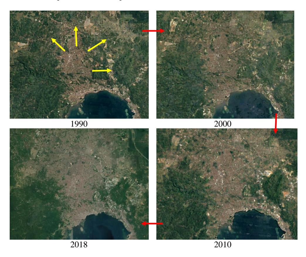
Figure 2. Urbanization in the city of Bandar Lampung in the period from 1990 to 2018 clockwise from the upper left (1990) to the lower left (2018). It can be seen in the picture that the city of Bandar Lampung is developing towards the east, northeast, southwest, and north, which is higher than the coastal area.
Source: GoogleEarth, 2019
In the meantime, in the context of flooding caused by overflowing river water, either due to siltation or lack of capacity, some actions of upstream communities have been accused of being the cause of flooding in the downstream area of Bandar Lampung, as described by the local authority as follows:
If the smart people on the hillside do not throw away their garbage anywhere it will be fine, the water will flow smoothly (local authority, 2018).
The statement above reveals two things. Firstly, there is a common opinion in the community that the people in Bandar Lampung city who live in the upstream region are well-educated. This is also supported by the fact that some higher education institutions are located in the upper area of
Bandar Lampung city. These priviliged people are accused of causing flooding in lower areas generally inhabited by poor people. More importantly, this is not only a matter of access to education but also a matter of the upper community having better economical-cultural opportunities to access a good education rather than the poor fishermen living in Bandar Lampung's lower area. Secondly, the downstream community is described as the antithesis of a well-educated society. But considering there is no clear boundary between the upstream and the downstream area, according to our analysis, the downstream community described as the antithesis of the community living upstream are the fishermen who live on the coast, especially those who still live on stilt houses above the sea. The people in these communities generally have low income, low property ownership, and low education.
Meanwhile, like the local authority in the statement cited above, the community in the lower area suspects that the problem of river water overflow is caused by the garbage massively produced in the upper areas of the city, blocking the drainage and river, which in turn causes flooding. Thus, the several potential hazards in the coastal area are caused by problems in the upper area of Bandar Lampung, the population of which has characteristics that are the opposite of those of the vulnerable coastal community. This situation underpins our previous analysis that the rapid and massive development of the upper area of Bandar Lampung contributes to the vulnerability of community in the coastal area.
Figure 3. Local small river in the Kangkung sub-district.
The coastal area, as explained in the previous sub-section, is the most vulnerable environment in the city. However, little effort has been done to find out the fundamental causes of this situation. For example, the studies from ACCCRN (2010) and BNPB (2016a) focused on vulnerability assessment using single-time dimension data. What the government does to overcome problems is often based on a short-term vision and not a comprehensive understanding of differences in time and space, frequently turning it into a commodity for politicians to gain popularity. Local communities are often profited from by politicians without any fundamental action plan to deal with the core problems, as told by an interviewee:
A mayor candidate promised us (the people) he could do something for the local inhabitants when he was running in the mayor's election. Then I requested him to have the shallow river in our neighborhood dredged because it caused flooding. Long story short, he won the election and fulfilled his pledge. Soon after dredging the flooding stopped. However, it has been six years since the river was last cleaned and now it is already shallow again (Kangkung inhabitant, 2018).
Meanwhile, people living on reclaimed land in Kangkung (see the explanation of reclaimed land in the subsection Morphological change of Kangkung's coastal area below) complain about improper solutions to tackle the problem of flooding. The authority prefers to physically improve the local streets (making them from concrete or making them higher) than dredge the small shallow river (see Figure 3). Improving the quality of the street based on the government's perspective may be sufficient to tackle the problems in the coastal community environment. Yet, this solution is not in line with the inhabitants' expectations. The government's intervention is perceived as a new problem by the inhabitants. The higher the street in this reclaimed land area (see Figure 4), the more vulnerable the people. The height of the local people's houses is increasingly equal to that of the adjoining street as a result of the physical improvement of the local streets. The local people suspect a garbage-filled small river was the cause of flooding in their environment, which is exacerbated by the road becoming increasingly high.
I have never experienced flooding as severe as now since I have been living here and since the concrete exists... There was just a measurement for improving the street but I refused. Then I was called and was questioned by the head of the sub-district (Kangkung inhabitant, 2018).
On another occasion, in early 2013, Pasar Kangkung, a part of the Kangkung area with around 20 other locations, experienced severe flooding caused by the collapse of an embankment in the Citra Garden real estate after heavy rainfall for several days (Alvin, 2013; Kompas.com, 2013). Citra Garden is a property development, of which construction started in 2005, marketed to uppermiddle class people (Ciputra, 2007, 2017). The response from representatives of the Citra Garden property management regarding the collapse of the dam suggested that a natural disaster was the primary cause of the collapse rather than a faulty construction.
This was a natural disaster (referring to the collapse of the embankment). The lake functions as a reservoir. If there was no lake, the flooding in lower areas would be more severe (Kompas.com, 2013, p. 1).
Morphological change of Kangkung's coastal area
Bandar Lampung's coastal area has been changing physically over time. Taylor (2010) classified Bandar Lampung's coastal land into three types: solid ground, reclaimed land, and houses over water. In Figure 3, we explain the classification of land types in Kangkung Bandar Lampung in more detail based on a map made by the Dutch colonial government in 1912 (KITLV, 1912). The coastal boundaries are indicated by a red line in Figure 3 below. We compared this with satellite images from 2001 (green line) and 2017 (white line) provided by GoogleEarth (GoogleEarth, 2018). The land above the red line is solid ground that already existed as solid land before 1912, based on the map arranged by Topographische Inrichting/Topographic Institute (KITLV, 1912). Meanwhile, between the red and green lines is an area of reclaimed land as a result of accumulated waste, or intentionally landfilled. The land between the green and white lines has stilt houses above the sea. Interestingly, the area between the red and green lines was originally also the location of stilt houses above the sea before it became reclaimed land.
Figure 4. Coastal reclamation morphology in Kangkung, Bandar Lampung. Source: GoogleEarth (2018); KITLV (1912); Authors (2018)
The people who live above the sea (Figure 5) regularly experience floods caused by an abrupt sea-level increase. Most of them are fishermen. According to Lassa & Nugraha (2015), people who stay on reclaimed land (between the red and green line in Figure 4) have physical vulnerability to floods, sea-level rise, and tsunami. They are most frequently blamed for living in a vulnerable area when a sea-level rise occurs. These people cannot afford proper housing and property. As explained in a previous subsection (Rapid massive land utilization in the upper area of Bandar Lampung), the lack of access to legal property and closeness to the source of their livelihood are the main limitations for people such as fishermen.
Figure 5. Houses above the sea in Kota Karang.
In conjunction with sea-level rise, the study from (Wiryawan et al., 1999), for instance, instead of emphasizing that the cause of the increased sea-level flood was climate change, they concluded that the cause of the sea-level rise was the unfinished and massive artificial reclamation (450 ha) of Bandar Lampung coastal areas conducted since 1983. The massive reclamation effort, in this case, was driven predominantly by economic motives rather than environmental preservation efforts (Kusumaputra, 2010). However, for instance, according to Wong et al. (2014), sea-level rise could be caused by local natural processes such as reclamation around the coast or by more global effects such as meteorological change. In other words, the decision to live above the sea can be interpreted as the inability to afford formal housing. This position, vulnerable to sea-level rise, is similar to that of other coastal communities caused by local and global processes.
Massive Commercial Land Reclamation
In Bandar Lampung, the massive land reclamation in the coastal areas supported by private companies (Deviani, 2012; Negara, 2017; Roy, 2016; Wiryawan et al., 1999; Wulandari, 2017) induces conflict. The reclamation was triggered, among others, by an attempt to improve the tourism sector (Kusumaputra, 2010; Mahi & Trigunarso, 2017), including the idea of a waterfront city (WFC) to strengthen Bandar Lampung's image as a tourist destination. Thus, this study focused on the massive land reclamation of the Teluk Betung Selatan sub-district (kelurahan), an area in between Kangkung and Kota Karang that sticks out into the sea (see Figure 3 above, the large area outlined with a white line). The soil used for reclaiming the sea came from the dredging of some of the hills in Bandar Lampung (Mahi & Trigunarso, 2017). In total, there are 32 hills in Bandar Lampung city, of which only three are in good condition, while the rest of them are in bad condition (Herumanika, 2018). One of the hills is in severe condition (Putra, Mulyana, & Caturiani, 2012) due to the reclamation project called Kunyit Hill. A similar method of engaging in reclamation by cutting the hill and filling the sea also took place on the island of Batam in Indonesia (Priyandes & Majid, 2009). Hill erosion can lead to floods and landslides (Herumanika, 2018). The Forum for the Environment (Walhi) in Lampung suspects that the absence of regional regulations (Peraturan Daerah/Perda) to control the dredging of hills is the leading cause of environmental issues related to several damaged hills in Bandar Lampung city (Herumanika, 2018).
One of the environmental impacts of reclamation is alteration of the tidal pattern (Priyandes & Majid, 2009). Coastal reclamation causes river estuaries to narrow, which disrupts the drainage and causes flooding or inundation during heavy rainfall combined with a rising tide (Wiryawan et al., 1999). The local people suspect that the environmental damage induced by the massive reclamation processes is making it more and more difficult to catch fish (Negara, 2017; Roy, 2016; Wulandari, 2017).
The reclamation projects have been halted for some time—for instance, in 1998 (Wiryawan et al., 1999) and 2016—due to environmental issues and the fact that contractor broke the regulations (Negara, 2017; Roy, 2016; Wiryawan et al., 1999; Wulandari, 2017). However, such cases are never seriously handled by law enforcers because they involve powerful actors (Lampost, 2017). The core of the problem in these cases is simple: the reclamation projects were environmentally problematic and recognized as such by the government, activists, non-government organizations (NGOs), and inhabitants. This might show that in realizing their aim, the dominant parties enable doing all ways including illegal procedures.
Related to the cases of massive commercial coastal land reclamation, we can summarize at least two environmental problems: hill dredging and reclamation of coastal land. Both generate environmental issues, contributing to increased vulnerability of the inhabitants of Bandar Lampung, especially the coastal communities. At this point, the transformation of nature in different space and time contributes to the vulnerability of the population in the coastal area.
We can also try to look for the cause of the environmental problems connected to the progress of spatial planning in Indonesia. Spatial planning after 1992 (the year the first Indonesia spatial planning regulation was passed) was still permissive and strongly depended on the political actors, which meant that the intentions of regional leaders strongly influenced it. As described by Rukmana (2015), the spatial planning in that period was not very transparent. The permissiveness of spatial planning brought consequences in the form of numerous investments in inappropriate land use. Some problematic environmental events, such as the damaging of most of the 32 hills and the coastal reclamation land issues, are the result of opaque planning and excessive permissiveness. The government gave permission and then they also stopped the projects.
Conclusion
Although a wide range of researchers have recognized the importance of vulnerability, different perspectives can be utilized to see what vulnerability is (Pamungkas, Bekessy, & Lane, 2014). However, at a practical level, various constraints cause projects to address only technical matters, leading to narrow solutions. For instance, the tempting trap of trying to solve social problems while neglecting the circumstances that are the source of the problem (the cause of vulnerability or the vulnerability itself). Consequently, some essential issues are ignored.
Firstly, this study showed that vulnerability assessments frequently see vulnerability problems as a sectional issue. In other words, the assessment mostly focuses on existing vulnerability, who is vulnerable and who is not vulnerable, and rarely questions why the vulnerable community is vulnerable. We argue that the metabolism of Bandar Lampung city plays a significant role in the production of vulnerability of some communities within the city. Therefore, we argue that projects supporting VRA studies need to embrace multiple disciplines. Some researches have provided more elaborative descriptions of vulnerability in the Bandar Lampung context, such as from Taylor (2010), Lassa & Nugraha (2015), and Elmhirst & Darmastuti (2018), which can potentially complement the existing assessment process.
Secondly, the narrow approach of executing VRA potentially leads policymakers to proposing narrow/superficial solutions to deal with existing and future environmental hazards and climate change impacts. In most cases this will not solve the community's problems and will only create another uneven situation. For instance, the people living on reclaimed land in Kangkung are still categorized as people living above the sea whereas the sea beneath their houses has become reclaimed land. It shows that the vulnerability chains in coastal areas will never be broken as long as the problem of affordable and sufficient housing for the fishermen is not solved. Without consideration of the vulnerability trajectory of the coastal community, stakeholders have only limited options and will only be driven to short-term solutions.
Thirdly, the results of this research also suggest that urban disaster governance should incorporate the dynamics and metabolism of how (social) vulnerability changes and forms over spatial and temporal dimensions in disaster risk reduction and climate change adaptation.
Acknowledgement
We would like to thanks to LP3 ITERA for the financial support through the research grant No. 134bo/IT9.C1/PP/2018. Also, our great gratitude to Warid, Irfan, Haikal, Ade, the interviewees, and the two blind reviewers.