
Introduction
Background
Morphology studies in general focus mostly on urban areas. Only few studies have been done on rural areas. Along with the development of rural areas towards modernization, it is interesting to study the morphology of residential environments in rural areas because they are thick with local values. The process of building a residential environment in a specific place always has different characteristics: the residential environment is formed according to the character of the inhabitants. In line with changes in the normative process, cultural roles and behaviour, the character of the community can also change because of modernization and the character of the environment. For this reason, the character of the community's housing environment must be studied to protect it from disappearing. Today's rural areas are increasingly developing towards modernization, where instead of leading to better development, it actually drowns the local characteristics that constitute its identity. In fact, these characteristics can make rural areas subsist for hundreds of years. Singengu Village's residential environment is a neighborhood in a rural area that has begun to undergo the process of modernization, especially seen from the physical changes in the buildings of the community residents.
Morphological studies have been done in the last ten years at different scales of assessment, both building scale and regional scale. A building-scale morphology study has been conducted by Ratih (2019) in the Bergenbuurt Road area, Malang city to identify the typology and morphology of the buildings that had previously been assessed in other studies to provide recommendations for the visual quality of the area. A study of building morphology was also carried out by Setyabudi et al. (2012), who analyzed the morphology of Jengki's house architecture in the cities of Malang and Lawang based on the level of change and the tendency of change. Morphological studies on buildings, especially on the courtyards of buildings, have been conducted by Guedouh and Zemmouri (2017), who specifically investigated the temperature and lighting of courtyards located in hot and dry areas. This study was carried out to identify artificial lighting strategies and thermal comfort conditions that are most feasible and suitable for buildings that have a courtyard.
Morphological studies at the regional level are prevalent, especially on an urban scale, for example, Fadhilah et al. (2013), Tallo et al. (2014), Wei et al. (2016), Wijaya (2017), Yan and Chen (2018), Mathewson (2018), McCartney and Krishnamurthy (2018), Sitompul and Roychansyah (2018), and Jones (2019). Overall, the studies in this field that have been carried out over the last ten years focused mostly on urban areas, such as the study conducted by Fadhilah et al. (2013), who studied the morphology of Kampung Kalengan in Bugangan Village, Semarang City through two aspects: firstly, a physical study that included courtyards/fields and road space, and secondly, a non-physical study covering socio-economic aspects. This study was guided by the rationalistic theory of space morphology of Carmona (2003), which includes elements of land use, building structure, plot pattern, and street pattern. The same thing was done by Tallo et al. (2014) by identifying the morphological patterns of cities in Malang through an analysis using the theory of elements forming an area by Zahn (1999 in Tallo et al., 2014), namely figure ground, linkage, and place. The identification study by Tallo was carried out based on the characteristics of activities in the space that affect the physicality of the city in accommodating ongoing activities within the city. The visual theory of the city (figure ground, linkage, and place) was used by Sitompul and Roychansyah (2018) in studying the three periods of the old city of Semarang. They found two factors that have
influenced the morphology of the old city of Semarang, namely economics and politics. In contrast to previous studies, Mathewson (2018) focused more on the morphology of the city in terms of the phenomenon of flooding and its influence on the spatial growth of cities, especially the city of Jakarta. As for McCartney and Krishnamurthy (2018) and Jones (2019), they focused on identifying the morphology of informal or slum areas that are very dynamic. McCartney and Krishnamurthy (2018) explain that slums need different handling from other urban areas, therefore, an appropriate strategy for subsequent planning practices should be aimed at urban slums in general. Jones (2019) studied a slum area in Lebak Siliwangi Village, Bandung through identification of the structure of the urban village settlements and their nature and changes.
Most of the abovementioned morphological studies, both at the scale of the house and the region, were qualitative researches using descriptive methods. An exception is Wei et al. (2016), which was motivated by the process of urbanization that affects the climate and the urban environment, and is a quantitative research through parametric studies related to the impact of urban morphological parameters on microclimate, namely the temperature and temperature of the average radiation. Wei (2016) recommends providing a suitable range of parameters that are beneficial for pedestrian comfort in urban areas. Yan and Chen (2018) used a combination of qualitative and quantitative approaches in uncovering the spatial transformation of Daxi Village in Anji, Zhejiang, covering physical, economic and social transformation. Similar to Yan and Chen (2018), Wijaya (2017) also conducted a morphological study on a village settlement area located in the Batu city area, Malang. The typo-morphological study of the area and settlement of Oro-oro Ombo Village, Batu city by Wijaya (2017) used the theory of regional typology by Lynch (1999 in Nuraini, 2010), using elements such as landmarks, paths, nodes, edges, and districts as physical aspects of morphology. The non-physical aspects viewed from the socioeconomic and socio-cultural side by Wijaya (2017) show that the development of tourism in the village has changed an agrarian society into an economically-oriented society that is still able to maintain a harmonious culture in managing businesses arising from the inclusion of the tourism industry in the village.
The above description shows that of the many studies on the morphology in a region, none presents a morphological review of a rural residential area. Therefore, it is interesting to study the morphology of a residential area in a rural area that reflects the specific character of its inhabitants with the same ethnic and cultural background, namely Mandailing. Not only to find out the character of the housing environment in the rural area but also to provide an overview for planners involved in Mandailing to understand that local character better.
Research Problem
This study was a morphological research with the focus on a rural area of a residential neighborhood in the mountains, i.e. the Mandailing community residential environment in Singengu Village. The description of the background above summarizes the research problem: what is the residential neighborhood morphology in Mandailing Julu Singengu?
Research Methods
This study is an interpretive historical study (Schwandt, 2001; Howell, 2013, Groat and Wang, 2002, Yin, 2003) that narratively constructs the morphology of the residential environment in Singengu Village through four sources: archives, documents, evidence from locations, and explanations from interviewees/eyewitnesses. The data were analyzed using a descriptive
method to describe the state of progress of each phase of the residential neighborhood in Singengu Village through three morphological components, collated based on the theoretical framework of Carmona (2003), Carmona (2008), and Nuraini (2019), namely: 1) land-use pattern, 2) building layout, and 3) the road network.
Literature Review
Morphology and Components of Morphology
Carmona (2003) revealed that morphological studies are related to the form and shape of a settlement environment. Form refers to the form that can be observed and is a configuration of several objects, while shape is a geometric feature or the external shape and outline of an object. Form emphasizes the shape consisting of various elements while the characteristics of each element can be clearly seen. Visually, each form element is in a single configuration, for example, a corridor formed by a row of buildings. Meanwhile, shape puts more emphasis on the external shape of the form, for example, a silhouette that in the context of the townscape is often referred to as the skyline. A collection of objects located above the ground surface can form certain shapes, such as linear, grid, concentric, radial, cluster, and so on.
Morphological studies are always related to an environment, both residential and settlement environments (Carmona, 2003). According to Carmona (2003), civilization always starts from the activities of settling in an environment until they form a large settlement complex. The complexity of the residential environment's growth then forms larger environmental units, namely villages and cities. Therefore, villages and cities cannot be separated from the residential and settlement environment.
Morphological analysis according to Carmona (2003) is always related to the settlement environment. There are four components of morphological analysis according to Carmona (2003), namely: 1) plot, which is the most fundamental morphological scale of observation, including physical components such as buildings and land use; 2) district, which is a set of plots with all the physical components in them, including demographics and the physical environment's characteristics; 3) cities, which morphologically constitute a unity of territory with the complexity of the structure and pattern of space as the center of settlements; and 4) territory, which is a unitary territory composed of tiered settler centers that has developed in stages. Conzen (in Carmona, 2003) states that there are four morphological components that need to be considered in the analysis of morphological studies, namely:
1. Land use
Land use is a key component in regional growth, which is a generator of activity systems that determine the pattern and direction of regional growth (Kaiser, 1995 in Carmona, 2003). This component also has a high level of temporality in terms of change, especially when associated with economic values.
2. Building structure
The structural component of the building is a representation of two aspects, namely the structuring of the building mass, which is related to how the buildings on a site are distributed, and the relation to the physical embodiment of space and buildings that represent the culture, history, and creativity of a society.
3. Plot pattern
This component is related to the dimensions (size), which are heavily influenced by the natural potential, such as contours and geological/geographical conditions. By law, a plot is limited by ownership, which affects the use and management of space.
4. Road network
This component greatly affects the efficiency and effectiveness of a region because of its function as a connecting line. The road network is also a representation of public space, which is considered a core generator of regional vitality.
The Bincar-Bonom Theory
The Bincar-Bonom theory is a theory of space-attachment that is rooted in the lifestyle of Mandailing tribes, who originally lived in the rural mountains and later moved to the valley of Mandailing. Bincar-Bonom refers to the direction of the sunrise (bincar) and sunset (bonom). It is the basis for the settlement layout of Singengu village through three concepts: parkauman, banua, and mangulaki pangkal (Nurainiet al., 2014b). Bincar-Bonom is not only applied at the micro-scale of the buildings, which regulates the location of the space in the house for its inhabitants (Nuraini, 2014b; Nuraini and Thamrin, 2017), but also on the meso-scale environment that regulates the locations of residential buildings (Nuraini, 2014a). Bincar-Bonom, which at first was only a conceptual perception that existed in the thought of the Mandailing tribal communities in the village of Singengu and their ancestors, turned out to have manifested itself in the physical settings of buildings and environmental elements (Nuraini et al. 2018). In the context of architecture, Bincar-Bonom has also been applied in shaping the design of the growing residential community, known as house expansion based on GDS-BB principles (Nuraini et al., 2019a).
The application of the Bincar-Bonom concept on two scales, building and environment, can be seen in Figure 1 and Figure 2.
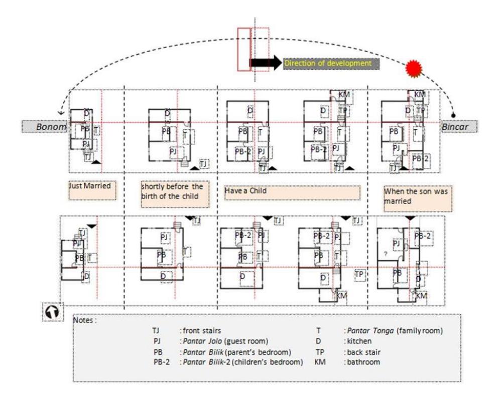
Figure 1. The process of house expansion based on Bincar-Bonom. (Source: Nuraini et al., 2018)
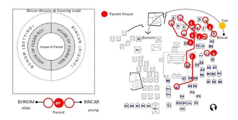
Figure 2. Dwelling arrangement based on Bincar-Bonom. (Source: Nuraini et al., 2014a)
Results and Discussion
The Overview of Singengu Village
Singengu Village is located in the middle of the Mandailing Julu landscape, precisely between two large mountains, Mount Tor Sorik Marapi in the west and Mount Tor Kulabu in the east. The boundary of the Mandailing Julu region to the west is Mount Tor Sihite, which borders directly on the Mandailing Godang area (Nuraini, 2019b). Nuraini (2019b) revealed that Singengu and the villages in Mandailing Julu are thought to have existed since before the 1800s. The development of Singengu Village shows a quite interesting phenomenon. The village is developing towards a hill to the south, Parkutahan hill. The village's development does not follow the shape of the river but stays away from the river. The development of villages in general can be traced through the process of spatial development. In the beginning of its development, Singengu Village was located at Tor Tanggi, or Tor Hutatinggi, the area at the entrance of the village where the pakkuburan (cemetery) and the madrasah (school) are now located, as can be seen in Figure 3. Tor in the Mandailing language means high but the area is basically just a hilly area and not a mountain at all. Singengu Village's landscape can be seen in Figure 4.
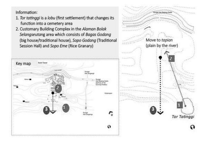
Figure 3. The first settlement of Singengu Village in Tor Tatinggi. (Source: Nuraini, 2019b)
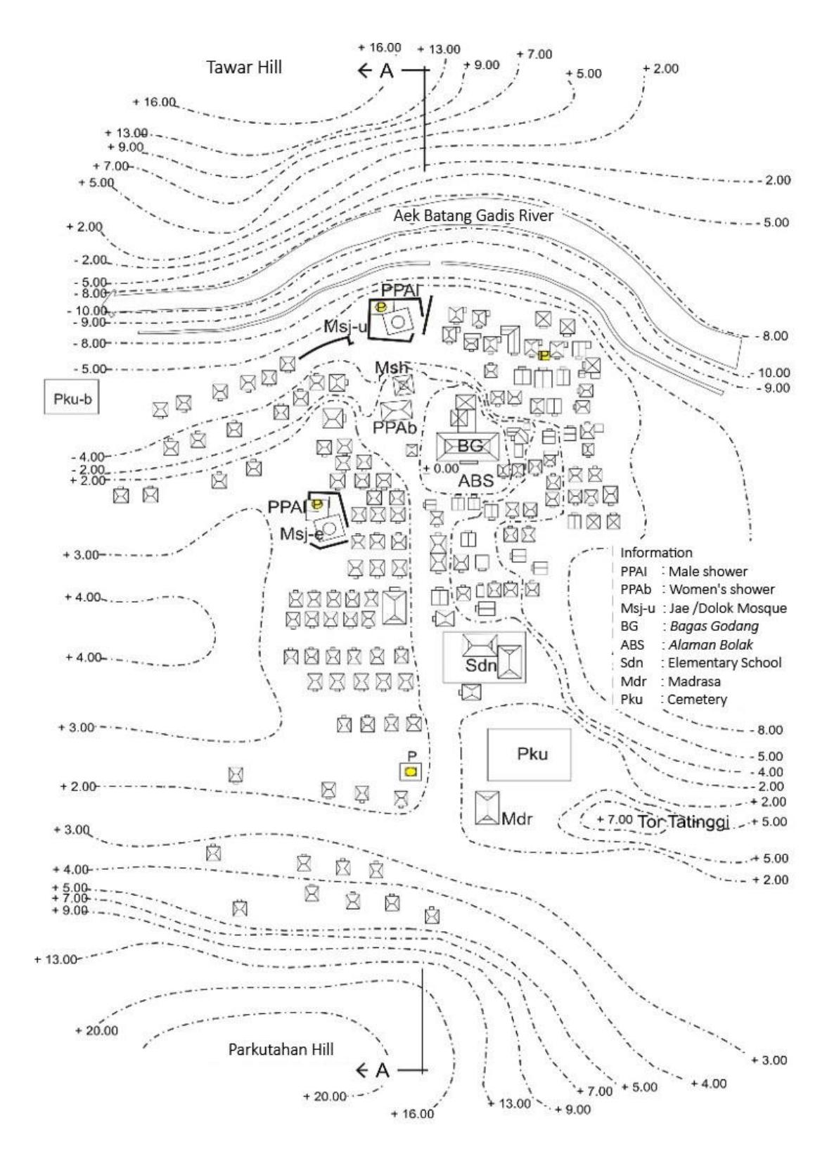
Figure 4. Singengu landscape. (Source: Nuraini 2019b)
Morphology of the Singengu Village Residential Environment
The information collected from archives, documents, evidence from locations, and explanations from interviewees/witnesses related to the history and development of the residential environment in Singengu Village summarize the development sequence related to the formation of Singengu Village's residential environment, as presented in Table 1.
Table 1. Development process of Singengu Village residential environment.
| Level of Development | Description | Code |
|---|---|---|
| Sosor | Foundation of a new village | M1 |
| Banjar | Small villages consisting of 2-5 houses | M2 |
| Pagaran | A larger village consisting of several banjar | M3 |
| Bona bulu | A village that has fractions/sub-villages and is the location of the | M4 |
| king's residence | ||
| Huta | A village that has traditional customs and is the residence of the king | M5 |
| Huta adat | A huta that has been compacted | M6 |
(Source: compiled by the author based on Nuraini, 2004, Nuraini, 2014; Nuraini, 2015; Nuraini, 2017; Nuraini, 2019b)
The data on the development process can be grouped into two aspects, namely physical and non-physical aspects. The development of the residential environment in Singengu Village can be further divided into six phases of development, namely:
- 1. Phase 1 banjar (before 1800)
- 2. Phase 2 pagaran developing into a huta adat (1800 to 1899)
- 3. Phase 3 huta adat, stage 1(1900 to 1950)
- 4. Phase 4 huta adat, stage 2 : developing and changing into a village (1951 to 1999)
- 5. Phase 5 village, stage 1 (2000 to 2015)
- 6. Phase 6 village, stage 2 (2016 to the present)
Each stage of the development of Singengu Village's residential environment was reconstructed through spatial sketches to get a picture of the spatial conditions at each stage. The beginning of a residential environment in Singengu Village was formed after the second phase. Previously, the ancestors of the Mandailing people who first descended from the mountains and settled in Hutapanopaan (now Kotanopan, the subdistrict's capital, approximately 500 meters from the village of Singengu to the east). Hutapanopaan (Kotanopan) was the first residential neighborhood. Then the ancestors of the Mandailing people moved to Tor Tatinggi (see Figure 3 in the previous description). The second move was made from Tor Tatinggi towards the north, which is currently the midpoint of Singengu Village's residential environment with alaman bolak (large yard) as the marker element.
Environmental Morphology of Singengu Village's Residential Area
The findings of the morphological stages of the Singengu Village's residential environment can be explained as follows:
Phase 1 – banjar (before 1800)
At the beginning of its growth, Singengu Village's residential environment consisted of six residential units. Based on interviews with key informants, village elders, and Mandailing historians, the village in Mandailing was established by a group of people who had a kinship bond. Brotherhood ties in Singengu Village's residential environment are marked by the presence of kahanggi, mora, and anakboru. Kahanggi is the eldest family group founder/eldest person and future king, mora is the family who gives daughters to kahanggi (the parent-in-law family of the king) and anakboru is the children-in-law's family (Nuraini, 2016). Phase 1 as a banjar can be seen in Figure 5.
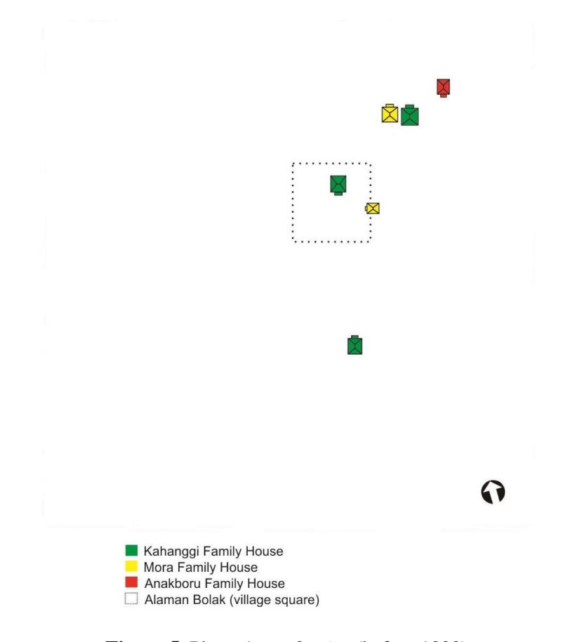
Figure 5. Phase 1 as a banjar (before 1800).
Phase 2 as a pagaran developing towards a huta adat (1800-1899)
In the second phase of its development, the pagaran Singengu began to develop towards a huta adat, which was marked by completing the traditional structure of a huta, i.e. a bagas godang (big house), sopo godang (traditional court hall), and sopo eme (rice barn) around the alaman bolak (large yard) as the main public space in the residential area. Around the 1800s, Islam entered Mandailing, brought by the Paderi tribe from Minangkabau. This stage was marked by the construction of the first mosque in Singengu Village's residential complex. Phase two is also marked by the construction of a special bathhouse for women around the alaman bolak (large yard) area. A bathhouse for men was in the area around the mosque and became an integral part of the mosque area. The family groups of kahanggi, mora, and anakboru increased. At this stage, new settlers came in. Their clans were different from the people in Singengu Village's residential environment. The new residents were from the Tanjung clan. Phase two of Singengu Village's development is shown in Figure 6.
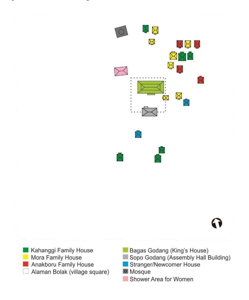
Figure 6. Phase 2 as a pagaran developing towards a huta adat (1800-1899).
Phase 3 as a huta adat, stage 1 (1900-1950)
This phase was marked by an increasing number of migrants who settled in Singengu. The king's residence, bagas godang (large house), also experienced an increase in the volume of space by expansion of the back area (kitchen). New settlements also increased, exclusively consisting of groups of kahanggi, mora and anakboru. The initial settlement area at Tor Tatinggi in this stage turned into a burial area for the royal family. In this stage, there was no permanent road in Singengu Village's residential area yet. Access for pedestrians relied on a row of alaman-alaman (courtyards) of houses forming a path. At this stage, a lopo (coffee shop) was opened by residents who lived around the alaman bolak (large yard) in the bagas godang area or the king's house, a place exclusively for male adults to hang out. At this stage Singengu was still called a huta by its inhabitants. In the next stage, the designation of huta was changed to desa (village) because of the national development program that translated the local term for sub-village (huta) into Indonesian. Phase three of Singengu Village's development is shown in Figure 7.
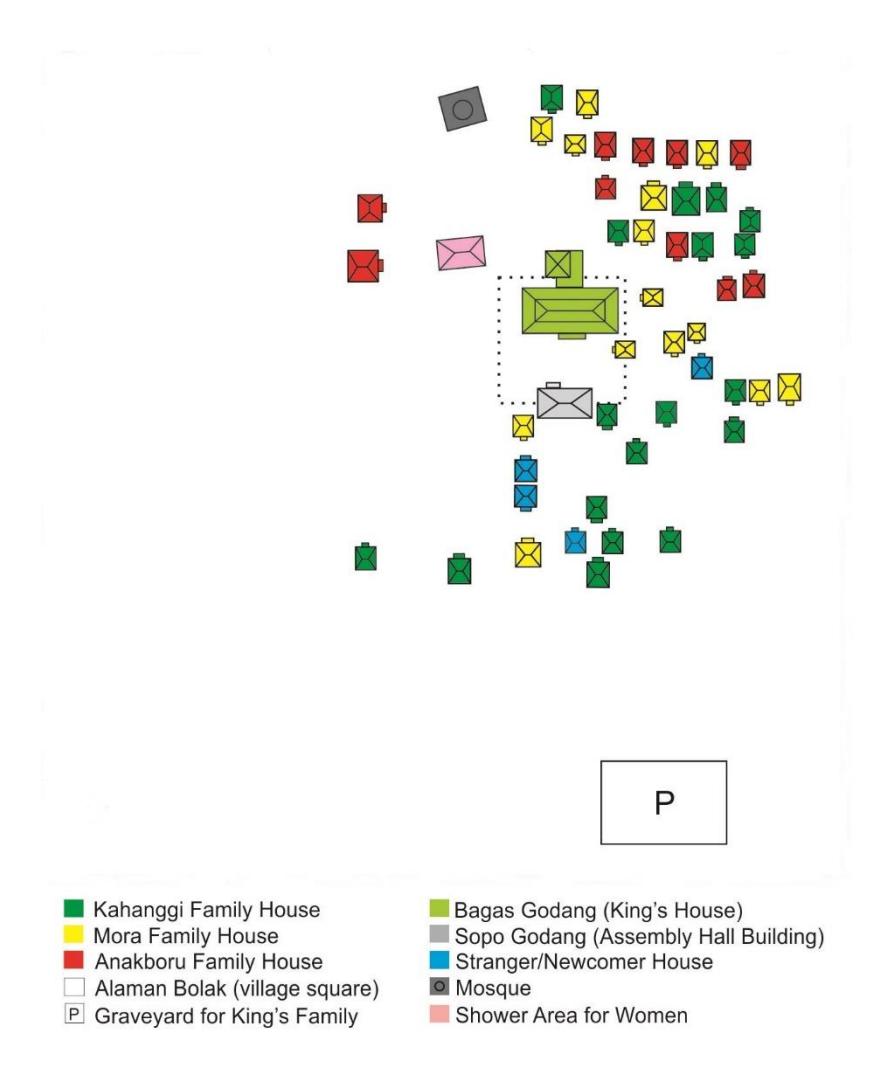
Figure 7. Phase 3 as a huta adat, stage 1 (1900-1950).
Phase 4 as a huta adat, stage 2: developing towards a village (1951-1999)
In stage four of the development of Singengu Village's residential environment there were quite many migrants, who still only consisted of kahanggi, mora and anakboru groups. The mosque was further developed with the construction of an outdoor terrace and improvements to the men's bathhouse in the mosque area. At this stage, a special mosque for women was built close to the women's bathhouse. This stage was also marked by the loss/damaging of the sopo godang (traditional court hall) and marked by the construction of a new bagas godang. The people called it the Bagas Godang Dolok, which was established by the King's relatives who developed Singengu Village towards dolok (above) in the southern area. The Bagas Godang Dolok was smaller in dimensions than the previous bagas godang in the middle of the alaman bolak (large courtyard) and also served as a dwelling. This stage was also marked by a change in orientation of the residential buildings, which were originally built facing each other and now turned facing the path. Most residential houses underwent physical changes, consisting of the expansion of space, the addition of new space, even the conversion of stilt houses to permanent houses on the ground. In this stage, parjagalan (food stalls) also began to open, which are usually specifically used by adult women to gather and chat. Migrants began to expand or enlarge their dwellings, while new dwellings continued to be built to form layers of old buildings. Phase four of Singengu Village's development can be seen in Figure 8.
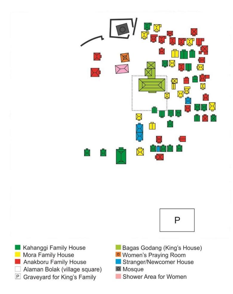
Figure 8. Phase 4 as a huta adat stage 2: developing towards a village (1951-1999).
Phase 5 as a village, stage 1 (2000-2015)
In Phase 5 of its development, Singengu formed an increasingly dense residential environment with the new designation of desa (village). In this stage, there were four new elements that marked the density of the residential environment, i.e. the construction of an elementary school, a clean water fountain from the government, the Julu mosque, and a new burial area in the western area. This stage was also marked by a change in function of the godang julu from a residence to a community meeting hall. Another sign of the developmental stage where Singengu became a village was the increase in occupancy in the western area of the alaman bolak (large courtyard), still consisting of three groups, namely kahanggi, mora and anakboru. In this stage, the residential environment of Singengu Village was divided into two major groups, Singengu Julu and Singengu Jae. Related to the provision of clean water, in the previous stages the community tapped clean water directly from the Parkutahan hill in the north of the village, which was channeled using bamboo gutters. Currently, clean water is still tapped from the hills, only bamboo gutters as a means of water distribution from the hills have been replaced by plastic water pipes. Phase 5 of Singengu Village's development is shown in Figure 9.
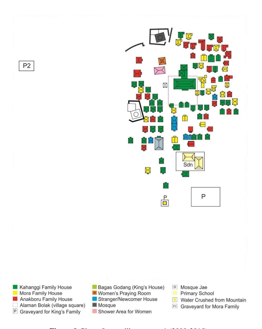
Figure 9. Phase 5 as a village, stage 1 (2000-2015).
Phase 6 as a village, stage 2 (2016-present)
Since 2016, Singengu Village's residential environment has undergone a significant transformation compared to the previous stages. In addition to being two different villages (Singengu Julu Village and Singengu Jae Village), residential density is a major feature of the transformation of Singengu Village's residential environment. There are more of food stalls (parjagalan), as well as coffee shops (lopo). In addition, near the king's burial area, a madrasah (Islamic school) was built. New settlements continue to be built on the outside of the village, up to the Trans-Sumatran highway. At this stage, the pedestrian trail was converted into a permanent road using funds from the National Community Empowerment Program (PNPM) for villages. When the road was built, some houses changed their orientation to facing the road. However, most buildings still maintained the orientation of the original house, i.e. facing each other. Phase 6 of Singengu Village's development is shown in Figure 10.
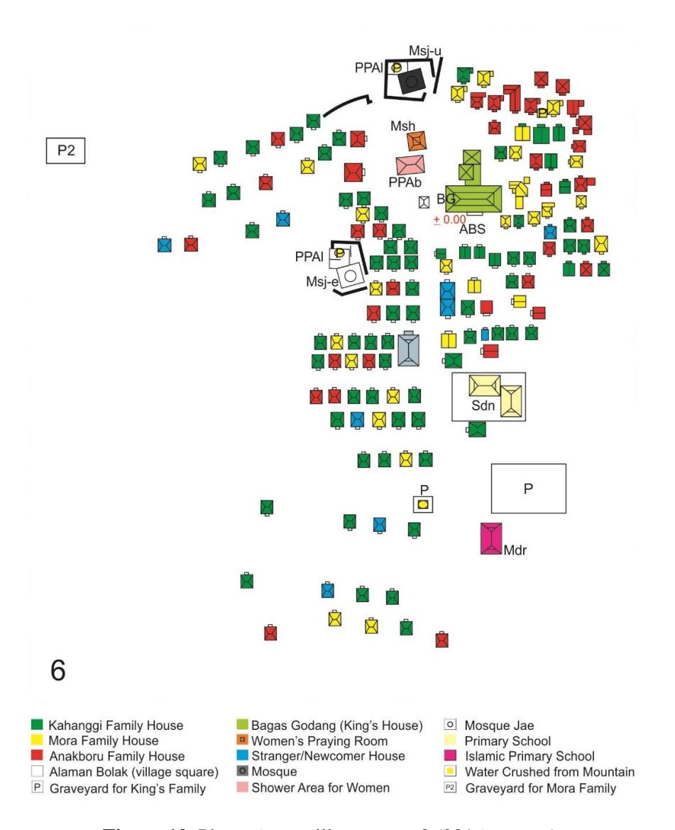
Figure 10. Phase 6 as a village, stage 2 (2016-present).
Physical Morphology Components in Singengu Village's Residential Environment
Land-use pattern
From the beginning, the land-use pattern in Singengu Village's residential environment had a specific concept that regulates residential areas in such a way that the residential environment was formed that is still maintained until today. The community centre, alaman bolak (large yard), was placed in the middle of the residential environment. The alaman bolak was the centre of activity, especially related to gathering activities of all citizens, both men and women, such as traditional wedding ceremonies, traditional inauguration ceremonies for new kings, court ceremonies, marriage ceremonies, and other customary events involving the whole community. Nowadays, alaman bolak is still a centre or gathering place for all members of the community when holding special events each year, such as the annual race, lubuk larangan, traditional celebrations and other special occasions.
The land that is used as a place to build dwellings on stretches from julu (upstream) to jae (downstream) and dolok (up/hill) to lombang (down/near the river) with the midpoint at the alaman bolak (large courtyard). The difference in land use can clearly be seen in the settings of worship facilities, public facilities, and social facilities. The worship facility for men, the mosque, is placed outside the central area (the midpoint, alaman bolak) and tends to be in the western area, while the mosque as a place of worship for women is placed near the central area. Public facilities such as schools/madrasah are located outside the residential area, while bathhouses are placed according to gender: the men's bathhouse is in the mosque, while the women's bathhouse is in the smaller mosque's area. Other public facilities such as lopo (coffee shop) and parjagalan (food stalls) are currently growing in number, utilizing the area in front of people's homes as their own business. However, at the beginning of the development, the lopo were first on the west side of the central area (alaman bolak), while the parjagalan were first found in the residential area on the east/Julu/upstream. Social facilities such as village halls were placed on the outside, but still within walking distance of residential areas, while the cemetery was placed in two outermost areas, from the main road to the south and from the west in the area of the entrance built in the early 2000s.
The land-use pattern in Singengu Village's residential environment is shown in Figure 11.
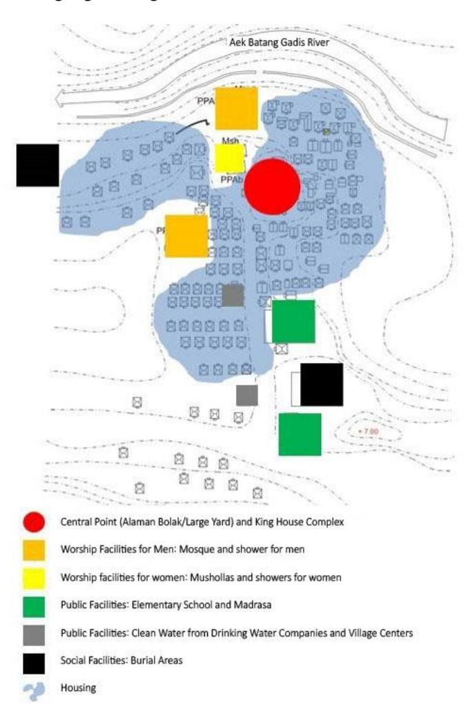
Figure 11. Land-use pattern in Singengu Village residential environment.
Building Layout
The buildings that can be found in Singengu Village's residential environment can be divided into two major groups: residential buildings and non-residential buildings. Residential buildings and community homes have a unique pattern because they are set according to the Bincar-Bonom principle oriented in the sunrise (bincar) and sunset (bonom) direction, as described by Nuraini et al. (2014a) and Nuraini et al. (2014b). The layout of non-residential buildings was discussed in the explanation of land use in the previous subsection.
Road Network
In addition to the unique land-use pattern and residential building layout, Singengu Village's residential environment is also unique in terms of the process of road formation. The streets in Singengu Village have basically been formed by footpaths between alaman-alaman (courtyards) that exist in every home of the community. Originally, the roads in the Singengu Village residential area were these footpaths. Therefore, roads are unknown in Singengu Village's residential environment. Roads have been physically built since the early 1920s, but people have never called them roads. People only know alaman (courtyard) and alaman bolak (large courtyard), where the king's complex resides. The development of the road network in Singengu can be seen in Figure 12.
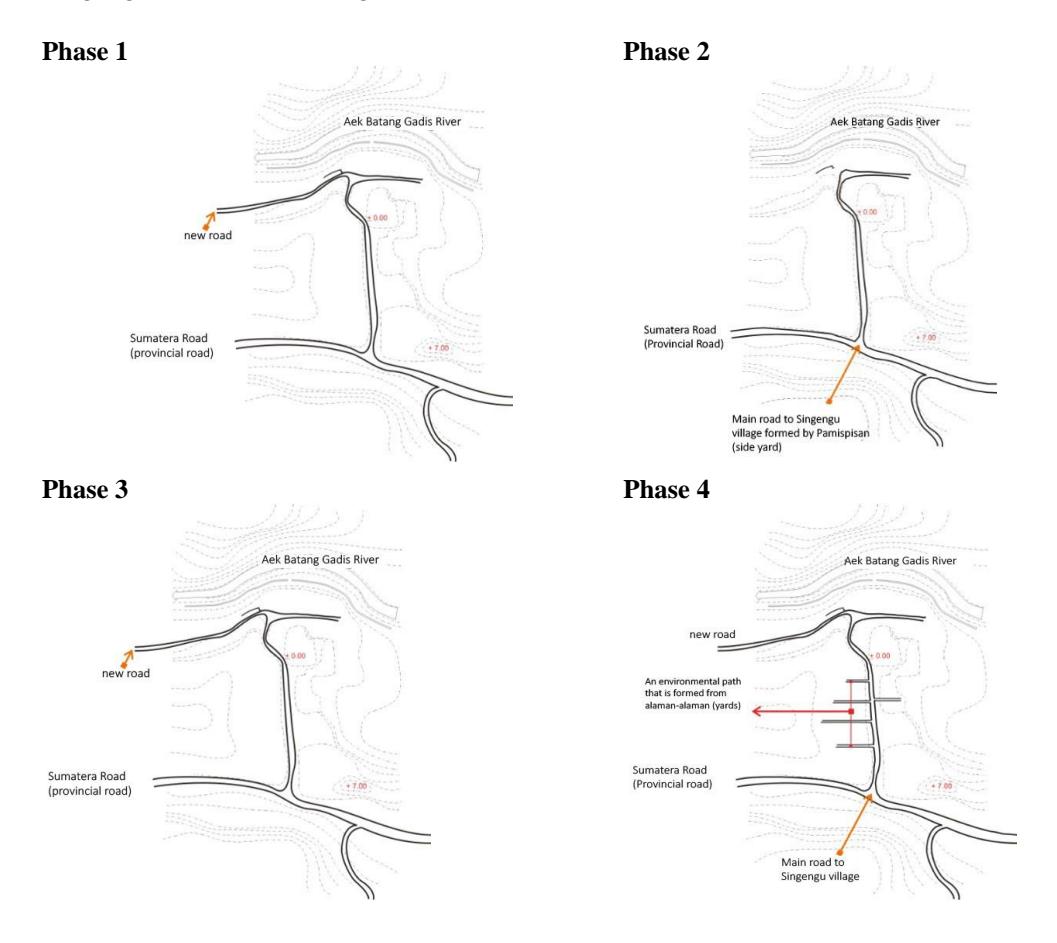
Figure 12. Development of the road network in Singengu Village. (Source: Nuraini 2014, in Nuraini, 2019)
The development of space in Singengu Village's residential environment is shown in Figure 13.
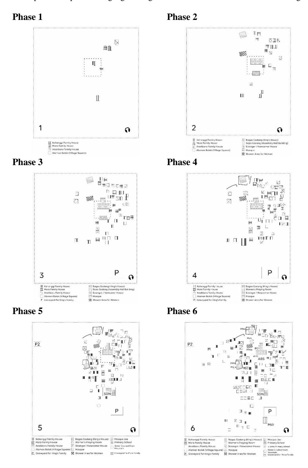
Figure 13. Development of space in Singengu Village's residential environment.
Conclusion
There are two results of this research: first, that the development of the morphology of Singengu Village's residential neighborhoods can be divided into six stages: 1) before 1800; 2) between 1800 and 1899; 3) between 1900 and 1950; 4) between 1951 and 1999; 5) between 2000 and 2015; and 6) 2016 to the present. The second finding is that the morphological components of Singengu Village's residential environment include three main aspects: land-use pattern, building layout, and road network. The road network in Singengu Village's residential environment is unique because it was formed after the construction of residential areas and not vice versa. The aspects of land-use and urban design patterns have a typical Mandailing character because they are consistent with the concept of Bincar-Bonom.
The morphology of the Singengu Village's residential environment developed in six stages. The process was closely related to the local concept of Bincar-Bonom that is still applied today. Each stage of the development corroborates the previous findings (by Nuraini et al. 2014a, Nuraini et al. 2014b; Nuraini, 2017, Nuraini & Thamrin, 2017; Nuraini et al., 2018) that the Bincar-Bonom principle is a major factor that affects spatial planning at all scales, both the micro scale of the buildings, the mesoscale of the environment, and the macro scale of the region. This research proves that the Bincar-Bonom principle was also the basis for the formation of the morphology of the Singengu Village residential environment; this can be seen especially clearly from the morphological components land-use pattern and building layout. The findings related to land-use pattern in Singengu Village's residential environment show that the land near the central area (alaman bolak) and julu (upstream) area on the east (direction of sunrise/bincar) are areas designated for public facilities for women. The areas in the jae (downstream) direction and in the west (sunset direction/bonom) are areas designated for public facilities for men. Public facilities that are communal for all residents, such as the alaman bolak (large courtyard) placed in the center and main area of the founder of the village/huta. Social facilities that do not comprise a building, such as the cemeteries, are placed in the outermost areas.
Suggestions
The results of this study provide some suggestions or recommendations for the protection and development of Singegnu Village's residential environment, which has a strong character in terms of the environmental characteristics of a mountainous rural residential area. Some ways to maintain it should be in the form of regulations for the development of local areas, especially regarding building regulations, and offer conservation concepts in accordance with potential areas. This is important because of the influence of modernization, which is quite strong in this area and has resulted in physical changes in the buildings. Physical changes that occur will result in a loss of the local character of Singengu Village's residential environment, which is arranged according to the Bincar-Bonom principle at different levels. However, the environmental characteristics and its natural settings, especially the current land-use pattern and residential building layout, are still very prominent and recognizable, and have shown continuity from the beginning of observation based on archived data, history, physical evidence, and interviews with key informants up to observations made in 2019. This shows that the Bincar-Bonom principle is still the main reference in regulating the layout and settings of existing facilities to form the morphology found today.
Important suggested recommendations: 1) efforts to develop Singengu Village's residential environment must always pay attention to and consider its morphological history so that the distinctive features of the Mandailing community's residential environment in mountainous rural can be preserved. 2) Development carried out in Singengu Village's residential environment should not change local terms into other terms that are not understood by the community. It is feared that the use of new terms will eliminate the local characteristics that are very thick with Mandailing cultural values, especially the concept of alaman and the concept of roads being unknown in Singengu Village's residential environment. It is necessary to to educate policymakers, planners and the general public about local terminology, so that everyone who is involved in planning for the Mandailing settlement area better understands the local character of the place. 3) The results of this in-depth case study carried out in a Mandailing community village can be used for comparison with other villages. Morphological study of residential areas in other village environments can be carried out to confirm if the Bincar-Bonom principle has also been applied in other residential environments in the Mandailing area.
Acknowledgements
Researchers would like to thank the Directorate of Research and Community Service (DRPM) for providing research funding for the Decentralization of Higher Education Basic Research Scheme (PDUPT) for the 2019 Budget Year (Second Year). Thank you also to the entire community, customary leaders, village heads, and elders in Singengu Village, who helped the researchers by providing information about Singengu Village and its surroundings.