
Introduction
Land-use change within the upper Citarum watershed is a phenomenon that, according to Rosyidie (2013), is hypothesized to be a factor in flooding, and one in which local governments can intervene via development control and land conservation efforts. The drivers of which may have been due to urban sprawl and/or peri-urbanization in the greater Bandung Metropolitan Area, which extends almost throughout the upper Citarum watershed. Both are similar and have similar ecological implications but develop via different patterns and are therefore not interchangeable. Urban sprawl is uncontrolled, unplanned, and uneven outgrowth of an urban area (Batty et al., 2003). In contrast, peri-urbanization is a process in which rural areas on/near the outskirts of established urban areas become more urban (Webster, 2002). Piorr et al. (2011) gave a framework in which peri-urbanization can be analyzed and characterized by the urban-rural continuum. They defined the peri-urban area as an extension of the dense, built-up areas around the city center and features patchwork development of urbanized pockets in an otherwise agricultural or undeveloped region. Within the greater Bandung Metropolitan Area, recent publications suggest periurbanization as the primary driver of land-use change within the region (Firman, 1996; Hudalah, 2007; Budiyantini & Pratiwi, 2014; Hudalah, 2016).
Land-use change, either caused by peri-urbanization or urban sprawl, will influence runoff (SCS, 1986) should there be changes in land use resulting in increased urban development. Expansion of built-up, urbanized areas into previously undeveloped areas is a known phenomenon in Indonesia (Tikno, 2012; Rosyidie, 2013). Deforestation (Hutagaol & Hardwinanto, 2011) is another known phenomenon that may contribute towards runoff change. Both studies have shown increased runoff as a result. As increased runoff levels can potentially result in flooding downstream (SCS, 1986), it is important to understand how land-use changes in the Upper Citarum Basin have influenced runoff. Peri-urbanization (Firman, 1996; Hudalah, 2007; Hudalah, 2016) and unspecified urban expansion (Wijaya, 2015) within the Bandung Metropolitan Area have caused significant land-use changes, in which agricultural and forest land were primarily converted into residential land uses. This, according to Rosyidie (2013), is hypothesized to contribute significantly to increased flooding due to increases in surface runoff levels upstream.
From the previously cited literature, changes in land use are a known factor in increased surface runoff. In contrast, peri-urbanization is a known driver of land-use changes in outlying regions of the Bandung Metropolitan Area. A link between increasing peri-urbanization within metropolitan areas and increases in surface runoff is plausible, according to Rosyidie (2013). However, the literature on this particular topic is limited, and Rosyidie (2013) does not provide an in-depth analysisthat is sufficient to implicate that peri-urbanization has indeed caused increases in surface
runoff. Based on the literature regarding surface runoff (SCS, 1986; Tikno, 2012), soil infiltration is tied to land cover/land use and soil type. Increasing land-use intensity will reduce soil infiltration and increase surface runoff , especially when it occurs in areas where soil and groundwater characteristics provide a naturally high soil infiltration capability, as in areas identified to have become groundwater recharge zones. Such areas must remain conservation zones, but according to Firman (1996), human development has been known to push towards said conservation zones, potentially causing increases to surface runoff as hypothesized by Rosyidie (2013). In order to answer Rosyidie's (2013) hypothesis, we, therefore, found a need to explore the relationship between peri-urbanization, general patterns of land-use change and how they impact surface runoff.
Therefore, in this study, we attempted to investigate how land-use change patterns upstream in the upper Citarum basin influence runoff, focusing on the Cirasea Sub-watershed, an upstream sub-watershed within the upper Citarum basin, located on the peripheral edges of the Bandung Metropolitan Area with significantly large groundwater recharge zones within. This study's result was then further studied to give possible policy recommendations. In this study we asked three questions: What are the land-use change patterns that occur in the study area? How do the known patterns of land-use change influence runoff? And lastly, what policies could be accomplished to help stem flooding downstream?
Contextual Considerations
Land Use Change Patterns in Bandung Metropolitan Area
Within the last couple of decades, land-use change within the greater Bandung Metropolitan Area has been significant. Urbanization is an Indonesia-wide phenomenon, particularly in West Java, whereby it is estimated that at least 86.6% of its population will live in urban areas by 2030 (Salim et al., 2015). Urbanization within the Bandung Metropolitan Area has extended far beyond the administrative limits of Bandung City, well into the countryside and even into the foothills surrounding Bandung (Wijaya, 2015; Ardiwijaya et al., 2014). Such urbanization drives out agricultural workers, tenants and smallholders alike (Firman, 1996; Firman, 2000), much of whom lack the necessary education to partake in non-agricultural work, resulting in the settlement and establishment of agriculture on previously forested, mountainous regions surrounding Bandung (Rohman, 2014). As a result, urban expansion not only creates pockets of urbanization within previously rural regions but may also drive deforestation elsewhere.
Whether urban expansion within the Bandung Metropolitan Area is urban sprawl or periurbanization is much debated. However, the literature surrounding this topic tends to lean towards peri-urbanization over urban sprawl. Even within the literature that supports urban sprawl as the dominant driver of land-use change (Ardiwijaya et al., 2014), the land-use patterns presented tend to conform to those of peri-urbanization. Firman (1996) found that this urban expansion has been driven mostly by new manufacturing industries developing alongside new road infrastructure, and the establishment of new urban centers surrounding an urbanized core. Recent literature (Hudalah et al., 2007; Hudalah et al., 2016) fully supports the idea of peri-urbanization being the driver of land-use change. With Hudalah et al. pointing out in 2007 and reaffirming again in 2016 that within the northern parts of the Bandung Metropolitan Area, urbanization has largely been driven by tourism, particularly, luxurious holiday homes (Hudalah et al., 2016). As a frame of reference in discussing peri-urbanization, Piorr et al. (2011) define an urban-rural continuum in which periurbanization can be understood. Within that urban-rural continuum, Piorr et al. (2011) determined the peri-urban area as the outskirts of a functional urban area, an area surrounding an urbanized core composed of scattered, low-density urbanization in an otherwise rural area.
Land-use Change and Runoff
Land use is known to influence runoff within a watershed due to its influence on soil infiltration capacity and groundwater recharge. Land-use change, according to Rosyidie (2013), is hypothesized to be the main factor behind the increase in flooding in the Citarum floodplain due to land-use changes in upstream, groundwater recharge zones. The link between land-use changes from nonbuilt-up areas into built-up areas and agriculture is well known (Tikno et al., 2012; Hutagaol & Hardwinanto, 2011; Verbeiren et al., 2011). Particularly severe is deforestation of groundwater recharge zones, as forests provide much-needed soil infiltration through the help of exposed tree roots and general vegetation cover, both of which stem runoff (Vandas, 2002). Deforestation in groundwater recharge zones has been shown to significantly increase surface runoff, according to Hutagaol & Hardwinanto (2011). In contrast, land-use change towards denser vegetation, reforestation and afforestation, in particular, is known to heavily reduce runoff, as has happened in South Korea, according to Kim et al. (2017).
Peri-urbanization meanwhile, is a known driver of the land-use changes mentioned earlier, from nonbuilt-up areas into built-up areas, as specified by Firman (1996), Hudalah, et al. (2007), and Hudalah et al. (2016), in the case of land-use change within the Bandung Metropolitan Area. As pointed out by Firman (1996), who studied peri-urbanization in the northern reaches of the Bandung Metropolitan Area, low-density urban development has (as early as 1996) encroached up to the 750-m (above sea level) threshold, set as the guideline for groundwater recharge zone conservation. The change of land use from densely vegetated forest/plantation land into lowdensity residential (as noted by Firman, 1996 and Hudalah et al., 2007) will result in a severe increase in surface runoff should it ever occur in a groundwater recharge zone.
Peri-urbanization, however, should not be assumed to be the one single factor behind changes in surface runoff. As pointed out by Hutagaol and Hardwinanto (2011), large-scale deforestation in groundwater recharge zones can also significantly impact surface runoff levels, as forests provide significant soil infiltration capacity to aid in alleviating surface runoff. Deforestation as an indirect result of urban expansion is known in the greater Upper Citarum watershed (Haryanti et al., 2007; Rohman, 2014). Still, the literature on this topic is insufficient and thus it cannot be concluded that occurrences of deforestation occur as its result.
Methodologies to link land-use change and changes towards surface runoff, in which land-use change can be directly implicated, exist in the literature. The rational method is an old (Kuichling, 1886; Thompson, 2006) method that has been used to try measure runoff based on precipitation and land use as its two variables, but one which is inaccurate and unsuitable for catchments above 1 km2 in area, especially on sloped land (Fantina, 2012). The curve number method, as described by the US Soil Conservation Service (SCS, 1986), is a much more recent methodology. It calculates a dimensionless runoff based upon a curve number, a parametric variable set based on a combination of the land use and hydrologic soil group of a given point/cell within the watershed being studied. Further elaboration of the curve number method can be used to output water discharge levels of watersheds (SCS, 1986; Asdak, 2001; Tikno et al., 2012), by taking into account a slope raster and a (24-hour maximum) rainfall raster. In order to link changes in land use with changes in surface runoff (Haryanto et al., 2007; Hutagaol and Hardwinanto, 2011; Ideawati et al., 2015), examining changes to the curve number of an area is sufficient, assuming a constant slope value and 24-hour maximum rainfall for the duration of the study period.
The ability to directly imply changes in land use as causing changes in surface runoff allows for increasingly focused policies regarding watershed management, in particular preventive management of flooding via land conservation measures. More accurate, sophisticated models to link land-use change and surface runoff exist (Verbeiren et al., 2011), including the SWAT model (Neitsch et al., 2011), which in itself is a derivative of the curve number method from (SCS, 1986), both of which allow the computation of a watershed's debit rate. However, in the context of this study's goals, following Tikno et al. (2012) and Hutagaol & Hardwinanto (2011), the methods used in this study are sufficient to link changes in land use with runoff and generate relevant land-use policies from the findings of this study.
The Cirasea Sub-watershed
The Cirasea Sub-watershed is one of the many sub-watersheds compromising the greater Upper Citarum watershed; it is also its uppermost sub-watershed, with the source of the Citarum (Situ Cisanti) being located in this sub-watershed. This sub-watershed is situated entirely within the administrative boundaries of Kabupaten Bandung. This watershed's topography includes mountains to the south and the northern, flat floodplains of the upper Citarum Basin.
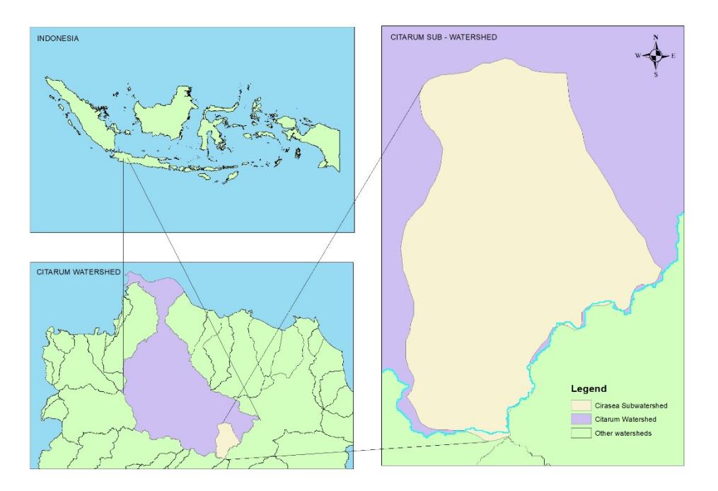
Figure 2. Cirasea Sub-watershed in the context of the greater Citarum watershed. (Source: Modified from Ministry of Public Works, 2019)
Administratively, 12 districts (kecamatan) are located, or situated partially, within the subwatershed boundaries. Those 12 districts are: Bojongsoang, Baleendah, Ciparay, Solokanjeruk, Majalaya, Arjasari, Pacet, Paseh, Ibun, Banjaran, Pangalengan, and Kertasari. The study area chosen was located at the outer fringes of the officially recognized Bandung Metropolitan Area (West Java Metropolitan Development Management, 2014), with Budiyantini & Pratiwi (2014) identifying a predominantly urban district surrounding Majalaya. The southern half of the watershed, namely the Pacet, Kertasari, Ibun, and Arjasari districts, are outside the Bandung Metropolitan Area as delineated by the West Java Metropolitan Development Management. The southern half of the watershed carries important ecological functions as a water recharge zone for the Upper Citarum basin, as identified in the technical documents of the Spatial Plan (RTRW) of Bandung Regency 2007-2027 (BAPPEDA Kabupaten Bandung, 2007). As the sub-watershed features a groundwater recharge area within its catchment area, it is important to understand landuse change patterns in that part of the catchment. The land-use change in groundwater recharge areas can significantly impact the runoff values (Tikno et al., 2012; Vandas, 2002; Kim et al., 2017).
In order to contextualize how our study area relates to the existing literature, we therefore need to review studies that have been done within our study area or at least surrounding the Bandung Metropolitan Area. The hypothesis stated by Rosyidie (2013), implicating peri-urbanization as a driver of increased flooding around the Upper Citarum River due to increased surface runoff levels, can only be confirmed via a thorough study with a study delineation that is within the Upper Citarum River basin.
Studies on similar topics regarding land-use change and/or surface runoff change in this watershed (and neighboring sub-watersheds of the Upper Citarum Basin) are limited, with Haryanto et al. (2007) including this sub-watershed in a study of the greater Upper Citarum basin, regarding changes in land use and surface runoff for a studied time frame between 1983 and 2002. On periurbanization it should be noted that detailed studies regarding peri-urbanization in the Bandung Metropolitan Area, as done by Hudalah et al. (2007) and Hudalah et al. (2016), were limited to the northern parts of the Bandung Metropolitan Area, closer to the Bandung city proper and with slightly different characteristics when compared to our study area. As studied by Hudalah et al. (2007) and Hudalah et al. (2016), the study area featured land-use change patterns that were highly influenced by tourism. In contrast, land-use change patterns in our study watershed were influenced more by industrialization (Firman, 2000).
As noted in Hudalah et al. (2007), tourism-driven land-use change have resulted in intense pressure upon previously existing land uses, particularly concerning forested land. In contrast, industrial driven land use change has tended to result in the densification of residential districts surrounding an industrial core, with lessened outward pressure to develop residential land into conservation areas (Firman, 2000). This may or may not lead to differing conclusions regarding peri-urbanization's influence on surface runoff in our study area. From this we can confirm (or disconfirm) the hypothesis of Rosyidie (2013), who implicated peri-urbanization to be a cause of increased surface runoff within the Upper Citarum River basin.
Tangentially related studies within the watershed, focusing on mechanisms possibly related to land use change (or attempting to reverse land-use change) exist. Rohman (2014) encountered farmers conducting illegal cultivation on conservation land within our study watershed, noting that these farmers had previously sold their land for urban/industrial development and were pushed towards illegal farming as they lacked alternative income sources beyond farming. Hapsari (2019) also encountered farmers farming horticultural crops on land zoned as protected forest, promoting agroforestry as a solution to the problem in mind, with legal, economic and environmental considerations. However, the connection between peri-urbanization and farmers extending onto protected forest land is unknown or at least tenuous (Firman, 2000; Rohman, 2014).
Data and Methods
Land-use change was identified by the use of GIS overlay techniques on land-use data from 1999 and 2018. Through the said process, we could identify patterns in land-use changes between 1999 and 2018. Additionally, the results of the overlay were used to form an aggregated land-use change matrix for the entire watershed to determine the aggregate amount of land-use change within the Cirasea Sub-watershed. Areas in which land-use change has occurred were separated into its shapefile and overlaid with administrative boundaries, allowing us to properly deduce and interpret land-use change patterns in the watershed.
Two methods exist that utilize land-use as a factor in runoff calculation. The rational method (Asdak, 2001; Thompson, 2006) is a simple method that multiplies the land-use runoff coefficient, rainfall intensity and watershed area under the general formula:
\[Q = 0.278 \times C \times I \times A\] with Q = runoff (mm3 /s), C = runoff coefficient of land use, I = precipitation, and A = area of a watershed in hectares.
The rational method in itself is useful for computing runoff, but as Asdak (2001) and Fantina (2012) have shown, it is inaccurate for computing runoff in large, regional watersheds. The SCS Curve Number method (SCS, 1986; Asdak, 2001) presents a better, if somewhat complex, method. The SCS-CN method follows the following basic, general formulation:
\[Q = \frac{(P - Ia)^2}{(P - Ia) + S}\] with Q = runoff (mm), P = precipitation, Iα as given by:
\[Ia = 0.2S\]
Derived, the general equation becomes as follows:
\[Q = \frac{(P - 0.2S)^2}{P + 0.8S}\] with S for the metric system given as follows:
\[S = \frac{25400}{CN} - 254\] where CN is the curve number. The curve number coefficient constitutes the rainfall-runoff relationship and is influenced by land use, soil classification, and soil moisture. Here, the value of Q is dimensionless and is used as an input for calculating runoff flow (q, m3 /s) at the head of the watershed. The curve number coefficients used in this study are given, following Tikno et al. (2012), assuming an average amount of soil moisture (see Table 1).
For larger, regional watersheds above 1 km2 in area, the SCS-CN method is much more accurate than the rational method (Fantina, 2012) and therefore, should be used in such cases. The curve number is given by the land use and soil hydrologic group, which is inferred from soil data following the NRCS National Engineering Handbook, Section 630, Chapter 7 (2009).
| No | Hydrologic Soil Group | ||||||
|---|---|---|---|---|---|---|---|
| Land Use | A | B | C | D | |||
| 1 | Forest | 25 | 55 | 70 | 77 | ||
| 2 | Grassland | 36 | 60 | 73 | 78 | ||
| Industrial, and impervious surfaces | |||||||
| 3 | (parking, roads, etc.) | 90 | 93 | 94 | 94 | ||
| 4 | High density settlement | 90 | 93 | 94 | 95 | ||
| 5 | Low-mid density settlement | 60 | 74 | 83 | 87 | ||
| 6 | Unused land | 72 | 82 | 88 | 90 | ||
| 7 | Agricultural plantations | 52 | 68 | 79 | 84 | ||
| 8 | Agriculture | 64 | 75 | 83 | 87 | ||
| 9 | Waterbody (rivers, lakes, etc.) | 98 | 98 | 98 | 98 | ||
Table 1. Figure of curve numbers for particular land use and hydrologic soil group pairs.
The SCS-CN method gives different runoff coefficients for each of the four hydrologic soil groups, as shown in Table 1. According to the NRCS National Engineering Handbook, Section 630, Chapter 7 (2009), the respective hydrologic soil groups can be described as follows:
1. Group A:
Soils in this group have low runoff potential. Soils in this group are mainly composed of sand, silty sand, with clay composition below 10%. Soils in this classification are particularly permeable. Soils in this group may have rock fragments and boulders comprising no more than 35% of the entire upper soil layer.
2. Group B:
Soils in this group have below-average runoff potential. Soils in this group are somewhat permeable. Soils in this group have a clay composition between 10% to 20%, with sand grains, silt and silty sand comprising anywhere between 50% to 90% of the total upper soil layer. Soils in this group may have rock fragments and boulders comprising no more than 35% of the entire upper soil layer.
3. Group C:
Soils in this group have above-average runoff potential. Soils in this group are somewhat impermeable. Soils in this group have a clay composition between 20% to 40%, with sand, silty sand, silty dust, silty clay, and sandy clay comprising the rest of the soil.
A soil can only be categorized into hydrologic soil group A, B or C if it fulfills the following conditions:
- 1. the groundwater depth is more than 60 cm from the soil surface
- 2. the depth between the topsoil and impermeable soil layers/bedrock is more than 50 cm
4. Group D:
Soils in this group have high runoff potential and are particularly impermeable. Soils with a clay composition above 40% belong to this group. Additionally, soils that do not fulfill the above requirements (groundwater depth, impermeable layer depth) to belong to groups A, B, or C, belong to this soil group.
Precipitation in the SCS-CN method for calculating runoff in millimeters is done using the Log Pearson III distribution to infer extreme daily rainfall for a 20-year return period. In the absence of detailed rain gauge data over our chosen watershed, daily rainfall data from BMKG was inferred from the nearest rain gauge. As a result, it was not possible to account for climatic rainfall variations within our watershed in the form of interpolated raster data, such as those conducted by Ly et al. (2011). The Log Pearson III distribution assumes a skewed distribution to the left, which is true in hydrology and must be assumed as such (Asdak, 2001).
To determine the rainfall at a given return period, Asdak (2001) gives the following formula:
\[\log P = y + Kc_s\] where y is the average of logarithms \(\frac{\sum \log p}{n}\) from given sample data, K is the frequency factor, and \(C_s\) is the coefficient of skewness. The formula for the coefficient of skewness is described as follows:
\[Cs = \frac{n^2 X^3 - 3nX^3 + 2X^3}{n(n-1)(n-2)s^3}\] where N is the number of samples given by the data, X is the logarithms of rainfall data (log P), and s is the standard of deviation.
Analysis of runoff was done using GIS, made possible by raster analysis techniques that allow for per-pixel calculation. The land-use data were overlaid with the hydrologic soil group shapefile, allowing us to input the respective curve numbers based on Table 1. The hydrologic soil group shapefile itself was an overlay of soil classification data and groundwater depth data that had been categorized manually into the respective hydrologic soil group according to NRCS (2009), translating the Indonesian soil categories into the soil classification used. Rasterizing the data allowed us to perform raster calculation, which we used to find and examine the curve number delta within the watershed and calculate runoff values and delta within the watershed between 1999 and 2018.
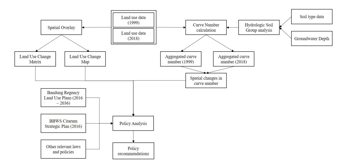
Figure 3. Analytical framework and workflow. (Source: Authors' Elaboration)
Based on this analysis results, we reviewed implications on policy and what policies could be accomplished to deal with the implications from our study results. The documents reviewed are: Renstra (Strategic Plan) BBWS Citarum (2016), Renstra KLHK 2015-2019 (2015), and RTRW Kabupaten Bandung 2016-2036 (2016), in addition to relevant laws in Indonesian Government Order 6/2007, West Java Provincial Law 12/2014, and Presidential Law 45/2018. Other documents include those from relevant stakeholders, such as Perum Perhutani and the Citarum Integrated Water Resources Management program, relevant to our study watershed. Content analysis was utilized to get a brief understanding of the documents we reviewed and how they relate to this study's results and its implications towards previously mentioned policies.
Summarizing the methodology used in this study, we provide an analytical framework and workflow that best integrates the different steps in this study. Our analytical framework and workflow is summarized in Figure 3.
The data used in this study were derived from data requirements for the methodology and the analytical framework used in this study. In order to fulfill the data requirements for the SCS-CN method, we used land-use data, soil data, groundwater depth data, and watershed boundaries (1:50000) from BAPPEDA Kabupaten Bandung. All data from BAPPEDA Kabupaten Bandung were in spatial form. The land-use data utilized in this study were land-use data for 1999 and 2018, giving a study period of 19 years and sufficient time to deduct land-use change within an area (Ardiwijaya et al., 2014; Wijaya, 2015). Soil and groundwater depth data were used to classify hydrologic soil groups for the watershed. Daily precipitation data for the SCS-CN method came from BMKG Klas I Bandung, sourced from the nearest rainfall gauge. Due to data constraints, we only used data between 2008 and 2016. The policy documents reviewed in this study were downloaded from the respective websites of the data-giving institution, except for the RTRW Kabupaten Bandung documents, which were obtained directly from BAPPEDA Kabupaten Bandung.
Results and Discussions
Land-use Change and Patterns, 1999-2018
Inferring from Figure 4 and Figure 5, land-use change within the Cirasea Sub-watershed between 1999 and 2018 has been significant. In the northern parts of the watershed, urbanization has occurred in the form of densification and the development of industries and higher-density urban settlements. Further south, land-use change mostly manifested themselves in the form of deforestation for agricultural land (horticultural, rice paddies or plantations), or simple deforestation resulting in previous forests being turned into scrubland. Interestingly, spatial expansion of urban areas has largely been limited outside of already existing urbanized/developed areas, with development mainly in the form of densification over expansion.
By evaluating land-use changes via a land-use change matrix (see Appendix I), we were able to infer a detailed conclusion of land-use change within the Cirasea Sub-watershed. The most significant change of land use between 1999 and 2018 was the conversion of forest land (deforestation) into upland agriculture (1281.85 hectares), scrubland (286.39 hectares), and plantations (241.74 hectares). Other significant land-use changes included the conversion of low/medium density settlement into industrial/high density settlement and plantations being converted into field agriculture and scrubland (286.39 hectares). Interestingly, urban expansion was limited, with most urbanization occuring in the form of densification rather than outright urban development. With urbanisation patterns are very much resembling that of periurbanisation in accordance with Webster (2002) and Piorr et al. (2011), confirming the hypothesis of peri-urbanization being the main driver of growth in the Bandung Metropolitan Area (Firman, 1996; Hudalah, 2010; Hudalah et al., 2016).
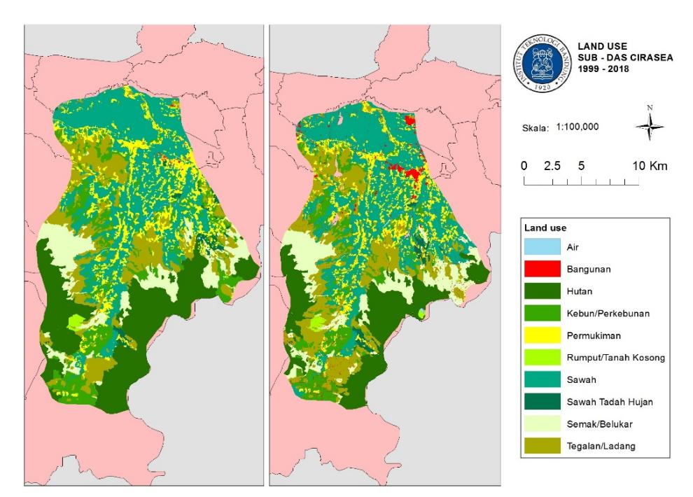
Figure 4. Cirasea Sub-watershed land use, 1999 and 2018. (Source: Modified from BAPPEDA Kabupaten Bandung, 2019)
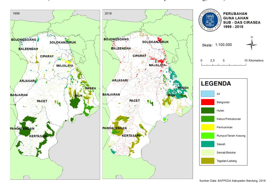
Figure 5. Cirasea Sub-watershed, changes in land use, 1999 and 2018.
Changes in Runoff, 1999-2018
The changes in runoff were evaluated by calculating (using rasterized data) the curve number of the entire sub-watershed for the years 1999 and 2018, based on the SCS-CN method, as pointed out in the method section of this paper (SCS, 1986; Asdak, 2001). The curve number at a given point is given by computing the land use and the hydrologic soil group classification.
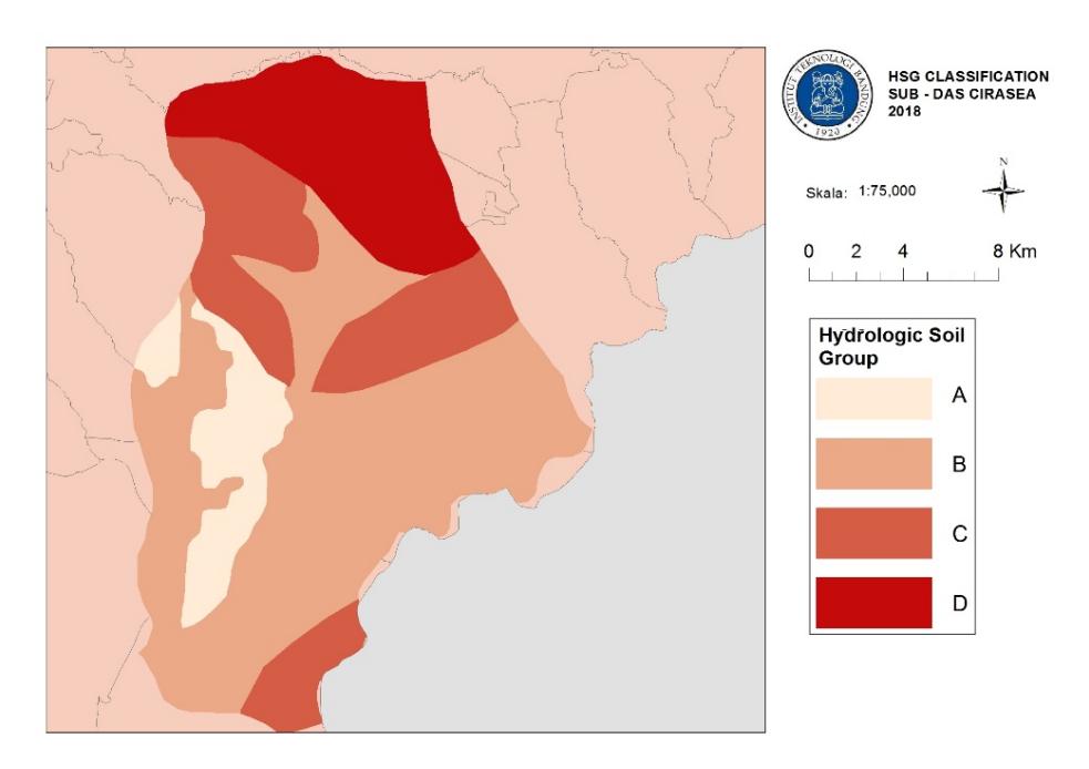
Figure 6. Hydrologic soil group classification.
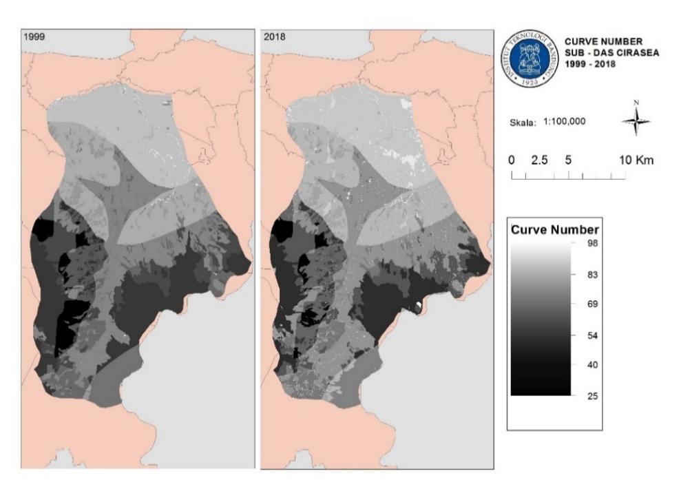
Figure 7. Curve number, 1999 and 2018.
The hydrologic soil group classification itself was computed per standards given by NRCS (2007). The soil data were reclassified to match the NRCS standards, with the groundwater depth component given by groundwater depth data from BAPPEDA Kabupaten Bandung. Much of the Cirasea Sub-watershed is a groundwater recharge area, with hydrologic soil group B being the most dominant hydrological soil group within the watershed (see Figure 6). The southern parts of the watershed should, therefore, be given priority as groundwater recharge zones, with corresponding land-use policy implications. In the northern parts of the watershed, a combination of shallow groundwater levels and latosol/alluvial soil types create an environment less conducive to groundwater recharge, making it more or less suitable towards sustainable development with manageable impacts towards the runoff characteristics of the Cirasea Sub-watershed.
Between 1999 and 2018, the aggregate curve number of the Cirasea Sub-watershed has risen from 70.98 in 1999, to 72.66 in 2018 (see Figure 7). From a 20-year extreme daily rainfall analysis, calculated using the Log Pearson III method (see Appendix II), we determined a design rainfall of 85 mm for analyzing runoff. Inserting the said design rainfall into the equations as given by the SCS-CN method provided an aggregate surface runoff number of 24.54 mm in 1999, and 26.89 mm in 2018 for the entire sub-watershed.
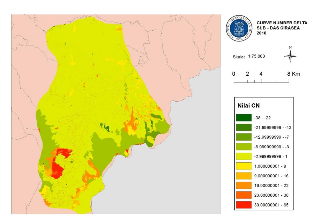
Figure 8. Curve number delta, 1999 and 2018.
While the increase in runoff is seemingly minor, the large size of the chosen watershed in our study (Cirasea Sub-watershed) has significant implications of increased runoff towards river flow at the watershed's mouth. Our calculations do not extend as far as river flow and/or flood modeling, but otherwise the land-use change in the Cirasea Sub-watershed is enough to be concerning, notwithstanding similar patterns of land-use change occurring throughout other subwatersheds within the greater Upper Citarum basin. Thus, it can be interpreted that the hypothesis of land-use change being a factor in increased flooding (Rosyidie, 2013) is at least partially true, with changes in climatic factors.
From the delta in curve number (per raster pixel) between 1999 and 2018, as shown in Figure 8, the increase in runoff was mostly due to land-use changes in the southern parts of the watershed, particularly areas in which deforestation occurred. Some increase in runoff has occurred due to urbanization, however, the increase in runoff is relatively minor. This is down to the fact that much of this urbanization has occurred in areas (see Figure 5) where soil infiltration rates are naturally low, due to differing soil characteristics in the northern parts of the sub-watershed (see Figure 6). Therefore, it can be implied that while peri-urbanization has occurred, its impact on surface runoff is slight (at least within our study watershed), unlike Rosyidie (2013), who hypothesized that peri-urbanization is directly correlated with increases in surface runoff.
Revelevant Policies and Implications
At the national level, policies are structured through two ministries, the Ministry of Public Works, governing watershed management via BBWS Citarum and Ministry of National Development and Planning (BAPPENAS), which coordinates watershed management across various actors, including non-governmental actors and governmental actors across three levels (national, provincial and local) of Indonesian government through its Integrated Water Resources Management plan. Policies at the national level regarding watershed management encompass all sections of watershed management and are created with the entire watershed in mind, aligning with national interests.
Policies relevant to this study (in particular, runoff and river flow control) conducted by BBWS Citarum, in accordance with the BBWS Citarum Strategic Plan (2016), include conservation, engineering, and infrastructure management. Conservation efforts include, among others, afforestation, community development, reforestation of eroded land (lahan kritis), land ownership mapping, cross-actor coordination, and integration of watershed-wide policies into local (kabupaten and kota) level land-use development plans. In addition, monitoring and evaluation efforts are conducted to ensure implementation of said policies by other stakeholders, particularly those at local and provincial government levels. Engineering efforts include the construction of check dams, gully plugs, infiltration galleries, slope terracing, and retention ponds. Infrastructure management meanwhile concerns day-to-day management and maintenance of already built watershed infrastructure. All of which are attempts to control river flow to manageable levels, thereby reducing flooding risk.
The Ministry of Public Works, in their BBWS Citarum Strategic Plan (2016) document, signals an understanding that runoff is a key planning and environmental issue that additionally relates to similar issues including erosion, flood control, and land-use conservation. The plan proposes significant budgetary measures for physical, engineered efforts, much more so than conservation efforts in the vein of afforestation, community-based land conservation, and/or land use/development control. Meanwhile, engineered efforts, such as check dam construction, may aid runoff control. Non-engineered, primarily vegetative, efforts can also be particularly effective in controlling or even reducing runoff within a watershed, as pointed out by Kim et al. (2017) regarding afforestation efforts undertaken in South Korea. Increasing urbanization in Indonesia combined with an aging agricultural populace, as pointed out by Salim et al. (2015) and Rohman (2014), may open up land for possible reforestation in the near future, with a lack of youth available to continue agricultural activities.
Conservation efforts are of particular interest due to their low-cost nature compared to the amount of money needed to build and then maintain physical flood prevention/reduction infrastructure, both upstream and downstream. In Indonesia, development control in the form of land-use
policymaking and its implementation (as according to Law no. 26/2007 on Land Use Planning) is primarily conducted by the local government (in this case, Kabupaten Bandung) in the form of administrative and criminal sanctions, based upon current land-use policy (RTRW Kabupaten Bandung, 2016-2036, see Figure 9). Therefore, it is necessary to conduct a mapping of land-use violations in upstream, groundwater recharge zones of watersheds and to restore lands into more proper, environmentally sustainable land uses.
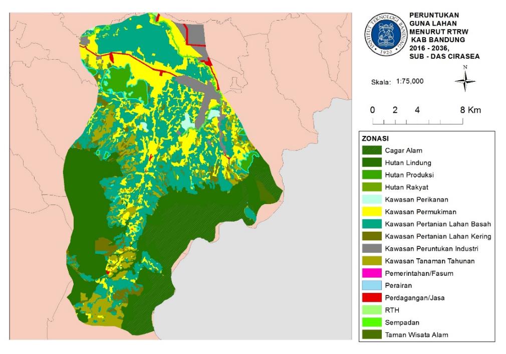
Figure 9. Land use zoning map, Cirasea Subwatershed in accordance with RTRW Kabupaten Bandung, 2016-2036.
(Source: Analyzed from BAPPEDA Kabupaten Bandung, 2019).
Existing land-use plans within the watershed provide an ample amount of forested areas on groundwater recharge zones upstream in the southern parts of the watershed, while also allocating zones for urban and suburban development downstream. The northern parts of the watershed, namely Kecamatan Majalaya, Kecamatan Solokanjeruk and Kecamatan Ciparay, are zoned for suburban and industrial development, aligning with the region-wide policy of having a local urbanized core (pusat kegiatan lokal) in that area in accordance with West Java Provincial Law 12/2014 and Presidential Law 45/2018.
Agroforestry is an interesting pathway to consider, in terms of increasing forested land in groundwater recharge zones. Agroforestry allows afforestation without negatively impacting the livelihoods of upland farmers (Hapsari, 2019). As Hapsari (2019) pointed out, agroforestry, particularly coffee agroforestry, reduces soil erosion and may even be more profitable in the long term compared to the current agriculture (tegalan/ladang) as practiced by upland farmers in Tarumajaya Village, Kabupaten Bandung. Coffee cultivation requires shade; therefore, coffee cultivation and afforestation complement each other very well. Kim et al. (2017) point out that afforestation, even if the primary goal is to reduce soil erosion, will also reduce runoff potential. However, as Hapsari (2019) pointed out, coffee cultivation requires three years before becoming
profitable; therefore, much social assistance is required to smoothen the transition from upland (tegalan/ladang) agriculture towards agroforestry.
Even with the best efforts in land conservation and development control, they alone may not be enough to control and reduce flooding downstream within the greater Upper Citarum watershed. As such, physical intervention (gully dams, check plugs, etc.) as planned by the Ministry of Public Works (BBWS Citarum, 2016) may still be needed upstream. In Kim et al. (2017), as studied in South Korea, afforestation took place over a long period, between 1971 and 2010, to produce an increase of 43% in soil infiltration and water retention. Likewise, there may be possible increases in extreme daily rainfall events due to climate change that have not been accounted for in this study and may require additional physical, engineered construction in addition to land conservation methods to reduce and control runoff and flooding within the Upper Citarum watershed.
Conclusions and Recommendations
Conclusions
In terms of land-use change patterns, the most significant is deforestation in groundwater recharge areas, in particular the conversion of forests into agricultural land. While peri-urbanization has indeed happened within the watershed, urbanization within the Cirasea Sub-watershed could be characterized as densification around Majalaya as opposed to straightforward urban expansion. Even so, land-use conversion from agriculture into urbanized land uses (residential or industrial) is not insignificant. As pointed out by Firman (2000), peri-urbanization is potentially damaging towards agricultural productivity in the intermediate area. The findings of Rohman (2014), of displaced, uneducated landless farmers committing deforestation and cultivating previously forested land may be connected to land-use change caused by peri-urbanization, however, further detailed study is needed to confirm this connection between peri-urbanization, agricultural displacement and agricultural deforestation in the context of the greater Upper Citarum watershed.
Land-use change has indeed influenced the watershed's surface runoff characteristics, as hypothesized by Rosyidie (2013). However, in this particular watershed, much of this change has mostly been caused by deforestation, as mentioned earlier in groundwater recharge areas. Similar results have also been noted by Tikno et al. (2012) and Hutagaol and Hardwinanto (2007) for different watersheds. The impact of urban development and peri-urbanisation here is indirect, and based on this study and the available literature on the subject, the link of which cannot be fully confirmed. Due to land-use change alone, the aggregate runoff coefficient of the watershed has increased from 70.98 in 1999 to 72.04 in 2018. Surface runoff (dimensionless) itself has increased from 48.98 mm in 1999 to 51.8 mm in 2018, assuming a designed 24-hour extreme rainfall of 120 mm.
So, what could be done to remedy the increased runoff? The latest kabupaten-level land-use plan, RTRW Kabupaten Bandung 2016-2036, zones a significant amount of land as forest-oriented land uses in areas that currently not forested. Implementing said plans via afforestation-based land conservation effort, in addition to stricter policing of land-use violations throughout Kabupaten Bandung, requires a concerted effort on behalf of the Kabupaten Bandung government to adequately fulfill intentions envisioned by said land-use plan. Resistance to this plan by persons affected may occur. Therefore the onus is on the government to figure out action plans which allow afforestation that does not economically displace the local populace, or even improves their economic standing, given their inability to find alternative employment, as pointed out by
Rohman (2014). One alternative we propose is coffee agroforestry (Hapsari, 2019), which has great potential to be developed in our study watershed area. However, other options can also be pursued, pending further study on local capacity, capabilities, and economic potential. Development of physical, engineered efforts such as check dam and gully plug construction by the Ministry of Public Works are possible methods to remedy increased surface runoff or even decrease surface runoff, but should not be used as the main policy with regard to reducing/controlling surface runoff due to the large expenses in construction and maintenance.
Recommendations
Further study is required on what method is best to ensure the implementation of afforestation and reforestation plans, as proposed by RTRW Kabupaten Bandung 2016-2036. Here, we propose agroforestry (based on the findings of Hapsari, 2019), but this is just one of many possible alternatives intended to reduce runoff to pre-1999 levels. Rohman (2014), for instance, prescribes further education and community development to develop non-agricultural economic activity in order to stem deforestation. Rosyidie (2013), meanwhile, proposed watershed management, integrating built, engineered runoff/flood control works in addition to land-use control.
This study was done without the assumption of factors related to climate change, which Rosyidie (2013) has hypothesized as a possible factor in increased runoff and flooding downstream. As per the SCS-CN (1986) methodology, extreme daily rainfall is a factor in the equations used by the method and may be influenced by climate change. Therefore, it could be that this climate change may have more of an influence on changes in runoff as opposed to land-use change itself. Therefore, further study is needed to figure out how climate change has influenced flooding and surface runoff within the greater Upper Citarum basin.