
Introduction
The planning of Kebayoran Baru2 in 1948 was an important political speculation of the Dutch colonial government, in the middle of the uncertain socio-political situation in Indonesia after World War II. The speculation was grounded in the colonial government's optimism: they imagined that they could regain control over the hard-fought federal state of Indonesia (Blackburn 2011: 216). This uncertainty made the planning process for Kebayoran Baru, led by H. Mohammad Soesilo and perhaps facilitated by Jac. P. Thijsse, both from the Central Planning Bureau, relatively fast, although it was only supported by limited available data3 . During its initial implementation phase, the 'developer' (i.e. Centrale Stichting Wederopbouw/CSW – Central Reconstruction Agency4 ) was unable to complete the process of acquiring the land for the proposed Kebayoran Baru of ±730 Ha5 . However, interestingly, in the transitional period after the transfer of sovereignty (27 December 1949), the Kebayoran Baru plan was not adapted. The plan produced by the Ministry of Public Works and Power in 1953 re-affirmed the plan that was produced in 1948 (Ministry of Public Works and Power 1953). Until the Kebayoran Baru development was formally declared finished in 1954 – although by then it had only achieved approximately 75% of its targets in terms of number of houses developed (Boedhiarto 2018: 46) – no changes in the plan were made.
The fast planning process, centralistic and technocratic but sufficiently detailed, took climate into consideration as well as local socio-cultural values. It reflected the dominant planning approach of the era. This classic planning approach (Moser 1993: 83-87; Taylor 1998), developed during the first half of the twentieth century, emphasized physical and design aspects.
2 The initial task was to develop a satellite city which, as Soesilo, the planner of Kebayoran, puts it, had never been done in Indonesia before (Soesilo nd: 319). The reason was to decentralize the population of Jakarta to its surrounding areas. However, the selected location for the satellite city was only 4.5 km away from the southern boundary of Jakarta, which was far from sufficient (according to Soesilo it should have been at least be 15 km) (Soesilo nd: 321), and no buffer zone was planned between Jakarta and the intended satellite city in that part. The intended satellite city did have eastern and western green belts planned. However, at least for the eastern green belt, insufficient efforts seemed to have taken place in its implementation (Claudio and Fahmi (forthcoming)). Thus, the intended satellite city failed to be realized.
3 Due to time pressure, the planning of Kebayoran Baru did not utilize, for instance, proper topographic maps; instead, it utilized aerial photo-based maps at a scale of 1:500. The contours of the land were estimated by the planner/engineer (Soesilo nd: 323).
4 CSW was primarily tasked to carry out post-war city reconstruction in the archipelago.
5 Kuswartojo (2019: 145) states that land acquisition for the Kebayoran Baru was completed in December 1948, so before the transfer of sovereignty (Silver 2018: 86). Land acquisition happened fast because it was not fully based on negotiation; the colonial government at a later stage unilaterally decided certain land prices (Silver 2018: 86). Consequently, according to Kusumawijaya (2017), more than half of the 4500 existing inhabitants (i.e. 2500) tried to resist but were warned by the authorities that "… if they refuse to move with due compensation they will be evicted with force without any compensation". However, the study by Claudio and Fahmi (2020) has demonstrated that, at least the zone planned for eastern greenbelt, was not fully acquired; up to the 1950s when part of the zone was decided as relocation site of ex-inhabitants of PTIK (Police Education Institute) Complex it was fully occupied by indigenous Jakartans (Betawi). Perhaps, due to this and other challenges JP. Thijsse humblely said: "an urban plan should not be rigid, but needs to be adjustable to changes and developments" (Sudiro 1953: 14).
It had also been codified through the enactment of the colonial city planning law (Stadsvormingsordonnantie/SVO) of 1948.
The present study was an attempt to reconstruct the core intellectual tenets of the city planning profession in Indonesia, especially from the perspective of Indonesian scholars. Other studies on the same era by foreign scholars, unavoidably, tend to utilize a euro-centric perspective6 . This study on the roles of Thomas Karsten (1884-1945) and H. Mohammad Soesilo (1899-1994) in city planning and development in Indonesia will hopefully bridge the gap between colonial and post-colonial city planning7 . With regard to Karsten, two facts need to be underlined. Firstly, ideologically he was emphatically attuned to the life and culture of the indigenous people (specifically the Javanese) and he tried hard to understand their concepts of architecture, spatial planning and culture in a broader sense 8 . Secondly, he was influenced by the opinions of his wife, Soembinah Mangoenredjo, a Javanese woman from the Dieng Plateau, on the spatial practices of the Javanese9 . Not surprisingly, therefore, his works and thoughts differed fundamentally from those of his fellow architects and town planners in the colony as well as from those who practiced in the Netherlands and other European countries (Coté and O'Neill 2017).
Problem Statement
This study investigated:
1. The planning approach for Kebayoran Baru;
- 2. The thinkers behind this Kebayoran Baru planning approach and their thoughts;
- 3. Its relevance to current urban planning approaches and practice in Indonesia.
6 This was also recognized by one of the most prolific writers on the history of architecture and urbanism in the Dutch East Indies, namely Pauline van Roosmalen. She admitted that her writings are often criticized because they tend to use an 'eurocentric' perspective, which, in her view, is entirely 'justified'. Among the reasons is that most of the material she refers to, which is limited in number, is material compiled by officials and professionals working for the colonial government or for colonial interests (van Roosmalen, nd).
7 Coté also indicates this: "To understand Thomas Karsten is to look beyond his specific contributions to the development of architecture and town planning in the Dutch East Indies and beyond conventional perceptions of colonialism and colonials. Ultimately his search for answers was resolved in a vision of a universal modernity in which the hierarchies and boundaries of colonialism and the dichotomies of East and West would be resolved." (Coté 2017: 20)
8 For this reason he actively interacted with Javanese cultural observers and aristocrats and was a member and the executive board of the Java Instituut. The Java Instituut was an organization founded by Javanese and European cultural observers and aristocrats, and aimed to revive and advance Javanese art (culture). See: O'Neill 2017: 47.
9 Interview with Oerip Mangoenredjo, Thomas Karsten's brother-in-law, 1989. Among the examples he provided was the design of the Djohar market in Semarang which, according to Mangoenredjo, was also influenced by Soembinah. It was Soembinah who informed Karsten of the custom of Javanese traditional traders to carry merchandise on their backs (bakul) and that markets in Java were full of flies, especially in the booths of meat and fish traders, and therefore both booths needed to be located on the second floor. In the last ten minutes before he died in a hospital in Cimahi during his Japanese internment, Karsten revealed how important Soembinah was for him as a source of inspiration (O'Neill 2017: 64-5).
'Planning approach' here means the perspective, or point of departure, from which planning and strategic choices are made. In this regard, 'approach' differs from 'method', which emphasizes the processes or techniques used.
Research Method
This study applied a qualitative (or constructivist) and narrative approach. Such an approach emphasizes the experiences, the thoughts and/or works of individuals as part of their efforts to respond to the professional challenges of their era. In this context the thoughts and contributions of two prominent figures in the planning of Kebayoran Baru, namely H. Mohammad Soesilo and his mentor Thomas Karsten, will be discussed.
Data collection was conducted through a literature review, documentation, interviews, and examination of artifacts.
Research Findings and Discussion
Kebayoran Baru: continuing the tradition?
Planning for Kebayoran Baru was deliberated in July 1948 and perhaps decided in August or September of the same year (Kuswartojo 2019: 145). As stated in Footnote 1, Kebayoran Baru was only 4.5 km away from the southern boundary of Jakarta. The plan was prepared by the Central Planning Bureau (Central Planologisch Bureau/CPB), where Jac. P. Thijsse and Soesilo were part of leadership. Two important factors that influenced the plan were: the limited supply of housing in Jakarta (Ministry of Public Works and and Power 1953) and the need for post-war reconstruction. The post-war reconstruction was also reflected in the involvement of CSW in managing the technical and financial aspects of the Kebayoran Baru development10 .
Figure 1. Map of Jakarta and Kebayoran Baru, 1951. Source: Surjomihardjo 1977: 66
10 Being involved in two important aspects of the Kebayoran Baru development, i.e. technical and financial, CSW was the actual developer of Kebayoran Baru.
The planning and development of Kebayoran Baru was a continuation of new town development, or city expansion, a tradition in the archipelago that was started during the first four decades of the 20th century11. The basic approach, method and regulation of this new town planning tradition had been laid out at that point. Karsten had been instrumental in its development in three roles.
Firstly, as a town planning professional in the Dutch East Indies he was deeply involved as a town planner or advisor in the development of several cities and new towns, such as Nieuw Tjandi in Semarang (1916), East Bogor (1917), Surakarta (1920), and Malang (1933 and 1935). All of these were considered conceptual successes and have subsequently been the subject of study and debate.
Secondly, as a reflection of his professional experience, Karsten had developed the concept of Indiese stedebouw (town planning in the Dutch East Indies), which contained the principles, norms, methods and techniques of town planning in the Dutch East Indies. When he presented a paper on this subject in 1920, the discipline of town planning was not only new in the Dutch East Indies, but also in the Netherlands (Bogaers and de Ruijter 1986: 78). Therefore, in the absence of adequate professional guidelines, it served as a guide not only for town planners but also for municipal government officials, even decades after the paper was first published (van Roosmalen 2017: 265-303; Coté and O'Neill [eds.] 2017).
Thirdly, in addition to his technical-planning role, Karsten was also instrumental in setting up the legal and institutional infrastructure of the field. He was involved in three colonial government committees relating to town development. One of them was the Town Planning Committee (Stadsvormingscommissie, 1934). This committee was established at the recommendation of the Decentralization Congress in 1933, which had called on the colonial government to centralize town planning regulations (Bogaers and de Ruijter 1986: 77). The involvement of Karsten in those committees reflected his growing reputation and expertise as a practitioner and main theorist for town planning in the Dutch East Indies. The results of the Town Planning Committee, i.e. the Town Planning Bill of Java and its memorandum, were presented to the colonial government in Batavia in 1938 to replace Supplement 1127212 (Bogaers and de Ruijter 1986: 77), although their enactment as law, with a number of adjustments (including the extent of its coverage, i.e. not only Java) was only done in 1948. The committee consisted of both Dutch and Indonesians (boemipoetera) experts and was led by J.H.A. Logemann; the intellectual leadership in town planning, however, was provided by Thomas Karsten, Logemann's right-hand man (Bogaers and de Ruijter 1986: 83; van Roosmalen 2017: 292). Two main figures in the planning of Kebayoran Baru, Soesilo and 11 Nieuw Gondangdia (Menteng, 1910), Darmo (Surabaya, 1914), Nieuw Tjandi (Candi Baru, 1916), Malang (1933 and 1935), etc.
12 Supplement 11272 (Bijblad 11272) was issued by the colonial government as guideline for town planning before the establishment of municipal governments (gemeentes). However, the guidelines were relatively vague, such as on the need to draft a 'rough plan' before any town expansion was approved (see Handinoto 2015:210).
Thijsse13 – some called them Karsten's protégés (Silver 2008: 87) – were also members of the Town Planning Committee in 1934.
Specific to the planning of Kebayoran Baru, Silver (2008: 85) indicates that an initial scheme may have been developed by Prof. V.R. van Romondt, a professor at the Technische Hoogeschool (Polytechnic) in Bandung. However, referring to his later exchange with Soesilo, it seems clear that this initial scheme was not accepted nor continued. Concerning this exchange, van Roosmalen (2008: 184-5) writes: "Van Romondt's criticism of the design for Kebajoran Baru focused mainly on the fact that, according to Van Romondt, the map showed little relationship with the structural and proportionate construction of traditional Javanese cities. Soesilo replied von Romondt that in his opinion a modern Indonesian city should be a synthesis between East and West" (translated). Therefore, it is quite likely that, being a planner with a modern viewpoint and a nationalist, Soesilo also attempted to apply his own vision to Kebayoran Baru.
Soesilo's modern viewpoint is reflected in his unpublished memoirs. Learning from the experiences of London and other cities during his attendance at a town planning congress in Hastings, England in 1946, he envisioned that a city could not be allowed to expand limitlessly, because "…its inhabitants cannot be served economically" and consequently "… all aspects of city life will no longer be comfortable" (Soesilo nd: 297). As a nationalist, Soesilo realized that Jakarta was not only in need of a large expansion of its housing supply at that moment but also, or especially, for a future in which the conflict between the Dutch and Indonesia would have ended.
Karsten and Soesilo: Their Backgrounds and Thoughts
Two important concepts of Thomas Karsten in new town planning are the concepts of 'social mix' and 'organic whole' 14. As will be discussed below, these two concepts left traces in Kebayoran Baru. The social-mix concept was developed in the planning of Nieuw Tjandi in Semarang, Thomas Karsten's first important work in the Dutch East Indies (1916-1919). Social mixing is the idea of housing groupings based on socio-economic achievement and not on ethnic or racial groupings, which was the norm of the time. This concept dismantled a centuriesold order going back to the indigenous pre-colonial city, as a way of controlling the plural society, grouping and organizing the population based on race or ethnicity (Santoso 2009: 9-17). In fact, apart from applying social mixing within a new town only, Karsten also connected the new town to the surrounding kampungs with pathways. Thus, to some extent there was 13 Apart from being the head of the Central Planning Board, the role of Jac. P Thijsse in the planning of Kebayoran Baru, if any, is not so clear. In fact, few publications mention his name in relation to this project. Therefore, it may be safe to say that his role was primarily to facilitate the work of Soesilo.
14 Other concepts that may not be unique to Karsten are the concepts of incorporating the local climate in architecture and town planning, and the concept of regional planning. He incorporated the local climate in perhaps all of his plans by designing spacious housing lots, placing trees along main and local roads (also part of his townscape plans) and including large green open spaces. This concept is not unique to him, as other architects/town planners of his era also applied this in one way or another. He applied the concept of regional planning in the planning of the city of Malang. At this time this concept was unique to the colony, even though it was much in line with international developments in this era (van Roosmalen 2017: 281).
integration both within the new town and between the new town and the kampungs (which were generally lower-class dwellings) around it15 .
The concept of 'organic whole' has two dimensions. Firstly, that a city can grow and develop as an organism (Bogaers and de Ruijter 1986: 79; Karsten 1920: 338). Secondly, that city planning "...must bring together what belongs together, separate that which has nothing in common; it must accentuate what is important and what is special, but at the same time bring it together with the ordinary and the common and through inserting rhythm and diversity, to make it attractive…" In this way, the city is planned to form a certain unity, namely as an organism with elements that are related to one another, and not left to its natural development (Karsten 1920: 339).
Thomas Karsten' 95-page paper Indiese Stedebouw was presented at the Decentralization Congress conducted by the Vereeniging voor Locale Belangen (Society for Local Interests) in Bandung, May 1920. Key aspects included:
- a. The direction of town planning must shape the town into an 'organic whole'. A town is a place where social life takes place, at work, in the park, on a trip; although different and separate, all of the above aspects must be organically connected, forming a unity;
- b. The task of town planning is not primarily a technical-engineering task but rather an organizational task. The town is dynamic and growing, not static, and must therefore be able to accommodate the developing needs of its people.
- c. Regarding the form of the town: the aesthetic demands of the community must be treated in line with practical, hygienic and economic considerations; a good form also requires good maintenance.
- d. Regarding the dynamics of the town, it must be remembered that what we plan and build today will be the core of the city in the future, which may be four to five times larger than what we have now. Mistakes we make now cannot be undone in the future.
- e. The kampung must be seen as an integral element of the town. Therefore, kampungs need to be fully integrated with the rest of the town. For this reason, kampungs need to be organized and equipped with basic facilities.
(Summarized from Karsten 1920: 338-350)
15 In the Memorandum of the Town Planning Bill for Java (1938), Karsten (and Logemann) reaffirmed the importance of this 'social-mix' concept. According to both, the application of what was called "... selective and strategic state-led zoning ..." at the same time meant "... to overcome disorderliness and potential conflicts". This disorderliness occurred because "... conflict over urban space" which, according to Karsten and Logemann, was created by the colonial government through, among other things, "... racial (and ethnic – EF) division of space" (Kusno 2018: 220). Karsten's efforts to sharply address the issue of racial and ethnic segregation of space were echoed much later in the post-colonialism discourse.
Karsten's socialistic tendencies went back to his student years at Technische Hoogeschool Delft (1905- 09), where he joined the Sociaal Democratische Arbeiderspartij (Social Democratic Labor Party) and his professional body, the Sociaal-Technische Vereeniging voor Democratische Ingenieurs en Architecten (Social-Technical Association of Democratic Engineers and Architects) (1907). It is with this tendency in mind that we can understand his writings in 1930: "For several years I have had in mind (since about '28) the hope that I might free myself of all architectural work, with the possible exception of public housing [...] and to devote my time completely to planning work [...]. More and more I dislike building for rich people." (Thomas Karsten's diary in Coté 2017: 19)
In this way, Indiese Stedebouw reflects the dominant approach of the time, namely the technocratic and centralistic approach, i.e. that the planning task was the 'prerogative' of town planners. However, in carrying out this task, Karsten encouraged social reform through the concepts of 'social mix' and 'organic whole'. These two concepts were taken over by Soesilo in the planning of Kebayoran Baru.
Before becoming the planner of Kebayoran Baru, Soesilo had worked at Karsten's architecture and town planning bureau for a long time, both in Semarang and after moving to Bandung. After working for more than seven years under Karsten, it was only in 1937 that he separated himself to continue his career as an employee of the Department of Public Works of the city of Batavia (Soesilo nd: 180). After Indonesian independence, as part of the Central Planning Bureau, he was involved in planning the reconstruction and improvement of the cities of Makassar, Ambon and Kupang (Soesilo nd: 301-05).
Before joining Karsten's architecture and town planning bureau, M. Soesilo had been a clerk at the colonial government-owned train company (Staatsspoorwegen) in Solo and near Kediri. He then worked at a rubber plantation in Pati as a supervisor for the construction of a building where the rubber sap was frozen and of a road (Soesilo nd: 97-113). He was a talented and selfeducated person – he had not finished his junior high school (Meer Uitgebreid Lager Onderwijs/MULO) nor a vocational school (Prinses Juliana School) due to illness. In both schools he probably acquired simple building knowledge and skills. At Karsten's bureau, he developed from his initial position as a draftsman into a praktijk ingenieur (practical engineer)16 in architecture and later in town planning. Thus, during his terms at the bureau he was able to internalize not only the technical competencies of an architect and a town planner from an expert of such high caliber as Thomas Karsten, but also his work ethic, such as his commitment to the development of the field of town planning (Soesilo nd: 158-9)17 . Not surprisingly, he admired Thomas Karsten. In his old age he said about his mentor: "The pencil in his hand was like something soulful". In the eyes of Soesilo, Karsten was "... not only an architect and at the same time town planner but also a high-class artist from the ranks of the architectural masters" (Kompas 30 September 1994).
The Kebayoran Baru of Kebayoran: Planning Approach
Like previous new towns in the Dutch East Indies, Kebayoran Baru was planned with a very centralistic and technocratic approach. The main agency for its planning was the Central Planning Bureau with Soesilo as the planner. He made the plan without consulting other parties outside CPB, except perhaps CSW, the 'developer' of Kebayoran Baru. In terms of the design, Kebayoran Baru adopted Karsten's two most important design concepts.
16 As part of his efforts to develop the town planning profession in the Dutch East Indies, Karsten through his position as chairman of the Sociaal-Technische Commissie (Social-Technical Committee) of the Society for Local Interests since 1935 organized an exam called Architect Locale Werken (Architect of Local Works) every two years. Karsten was a co-examiner for the architecture and town planning category (Bogaers and de Ruijter 1986: 76). Those who passed this exam became qualified praktijk ingenieur (practical engineer).
17 For example, Soesilo was able to write articles on town planning, published in the magazine Locale Techniek of July and November 1935 and May 1936 (Soesilo nd: 159). According to Soesilo, Karsten valued these articles as supports to such a commitment (Soesilo nd: 159).
Firstly, the 'social-mix' concept, which in the planning of Kebayoran Baru was applied at two levels. At the first level, the accommodation of three types of house, namely: large type/twostory villas (300-3500 m2 plots), medium type (200-600 m2 plots), and common people's houses (140-300 m2 plots). At the second level, good access to the surrounding kampungs, such as Kebayoran Lama in the west and Manggarai in the east, and other nearby kampungs, in addition to access to the city of Jakarta in the north.
In applying the 'social-mix' concept Soesilo did not, however, place socio-economic housing classes in close proximity to each other. Villa-type houses, for instance, were located in Block J, while common people's houses were in Block S (see the map of Kebayoran Baru below). Nevertheless, each type of housing had good access to centers of activity at a reasonable distance (markets, schools, mosques/churches, public open spaces). These common facilities were used by all socio-economic strata of Kebayoran Baru's residents. Firman (interview, March 2019), who spent his childhood in Kebayoran Baru, remembered how he and other children of the Kebayoran Baru used to bike and play with children from nearby neighhoods and kampungs. Some of those neighborhood and kampung children were also their schoolmates. Later, while most first- and second-generation residents of Kebayoran Baru had moved to other places in or outside Jakarta, they were still connected to one another by good memories of their past (interviews with Dini, April 2019; Firman, March 2019; Ano, April 2019).
Strengthening the application of this concept, some of Kebayoran Baru's houses were occupied by ministry employees, known as the Agriculture Department cluster, the Financial Department cluster, the Bank cluster, and so on. This, again had a role in building bonds among inhabitants, which lasted for decades, over several generations18 .
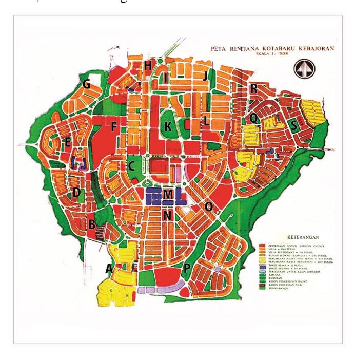
Figure 2. Map of Kebayoran Baru with block division. Source: Ministry of Public Works and Power, 1953
18 Interview with Dini, a second-generation dweller of Kebayoran Baru, April 2019. See Boedhiarto and Fahmi 2019.
There is, however, also criticism, for instance, about the way Soesilo took existing inhabitants of Kebayoran into account in his plan. Parallel to Footnote 3 above, Soesilo in his response to the criticism from van Romondt said: "As a matter of fact, of course the existing inhabitants of the area will not be able to afford the future township that we are building. They have to move." (Kusumawijaya 2017) Perhaps Soesilo was not fully aware of the consequences of his response, as he was more an engineer than a socio-technocrat. Furthermore, the pressure of time may have prevented him from thinking of other possibilities to accomplish his task. His contribution, as he contemplated later, "for the good of my country and my nation." (Soesilo nd: 322)
Secondly, the concept of 'organic whole' was operationalized by the planner of Kebayoran Baru as: connecting green spaces, social facilities and workplaces with good and adequate roads, and good landscapes and townscapes as accents. In addition, Kebayoran Baru also provided a large number of well-distributed green open spaces, social facilities (schools, markets, worship facilities, playgrounds) at various scales, and workplaces (both commercial and public), mainly at the center of Kebayoran Baru. In short, Kebayoran Baru was a city that was self-contained as well as aesthetic. This enabled the new residents of Kebayoran Baru to fulfill their daily needs without necessarily needing to travel to 'far-away' Jakarta. Of course, these facilities were not completed all at once. Firman (interview, March 2019) remembered how his parents, as a young family, who had moved from the well-established settlement of Menteng, were initially unhappy but were later pleased due to the gradual completion of the facilities in the Kebayoran Baru.
Conceptually, similarities between the design of Kebayoran Baru and the design concepts of Thomas Karsten are given in Table 1.
Table 1. Similarities Between Kebayoran Baru Design Concepts With Those of Karsten
| No. | Design Concepts of Kebayoran Baru | Design Concepts of Thomas Karsten |
|---|---|---|
| 1. | The division of the Kebayoran Baru according to blocks (A to S), each block separated by a road network and/or green spaces. | Division in blocks, each block separated by a road network or green spaces. |
| 2. | Kebayoran Baru accommodated various socio-economic groups. Different sizes of houses occupied different blocks or environments, but were all connected through a network of roads and shared playgrounds/parks/facilities. Kebayoran Lama in the west and Manggarai in the east of Kebayoran Baru were connected by roads. | The concept of 'social mix': accommodating various classes/groups that are socio economically different. Each group occupies a different neighborhood but all are connected through a network of roads and parks or common playing fields. Connections with surrounding settlements (kampungs) are facilitated by pathways. Public facilities such as schools, markets, mosques/churches, and open spaces, were also places of interaction for all socio-economic classes. |
| 3. | The roads that connected the center of Jakarta and the center of Kebayoran Baru (i.e. Block M), namely Sisingamangaraja Street and Pattimura Street, and the road that connected Block M and Bogor (and Manggarai), namely Monginsidi Street, were relatively straight and wide. Collector roads (Jl. Senopati, Jl. Wijaya, Jl. Gandaria) tended to be circular. | Roads must have a hierarchy so that intuitively the road user understands where it will lead. The main road that connects to the city center is relatively straight, wide and uninterrupted. Meanwhile, collector roads and local roads tend to be circular, shorter and narrower. |
| Block M, as the center of Kebayoran Baru, was placed in the middle. Santa Market, Mayestik Market and Block A Market were located in three other sections of the city (East, West and South). Primary schools were in residential areas, while secondary schools were placed in the middle accessible places. | or in easily | Public facilities, such as schools, markets and sports/field facilities, must be located in key locations, either near housing (for example elementary schools) or on the corner of a major road. Kebayoran Baru also provided spaces for offices/places of business, so as a whole it was relatively self-contained. These facilities could be accessed easily and were relatively close to one another. |
|---|---|---|
| The design of Kebayoran Baru utilized the slightly hilly topography of the region; two rivers flanking the Kebayoran Baru in the west and east were planned to be part of a green belt. | The city characteristics, local elements. | plan needs to provide two a comfortable and beautiful environment, and be able to accommodate |
| Kebayoran Baru had adequate parks and playing fields, although some of these were later converted into offices for the Ministry of Public Works and People's Housing and the Attorney General. | Karsten attached great importance to parks and plants as influencing the local climate and the aesthetic function of the city19 |
Source: Field observation and review of documents
Notes and Lessons Learned
Starting in the 1950s, the nature of the educational approach and the practice of city planning in Indonesia gradually changed. This was in line with the increasingly disharmonious relations between Indonesia and the Netherlands over a number of issues, which included the freedom of Papua and the nationalization of Dutch companies, and resulted in the exodus of Dutch citizens from Indonesia (van Roosmalen 2015: 114-15). In the first half of the 20th century, the orientation of town planning practices in the Dutch East Indies was influenced by those educated in the Netherlands or other European countries. Consequently, Dutch/European planning principles were taken into account, such as paying attention to detail, limited scales, and taking climate and socio-cultural factors into consideration. Karsten's approach focused on design (and engineering), although he also paid attention to the social organization of the city and regional planning (in the case of the Malang town plan).
In the second half of the 1950s, the orientation of city planning education and practice shifted to America and other countries. This was influenced by the arrival of city planning advisors who assisted the (central and regional) government and educational institutions (i.e. Institute of Technology Bandung and University of Gadjah Mada in Yogyakarta) after the departure of many Dutch experts in 1957. This new orientation brought different planning approaches and changes in the scale of planning (covering the local, city and region and even national scales).
19 See Karsten 1920: 341. Furthermore, according to the Town Planning Committee, "modernization of the city was more than a functional reorganization: it was also an ideal aesthetic. Beauty, in the eyes of the town planners, was order. In addition, a well-kept urban landscape is important because it served a societal interest" (van Roosmalen 2015: 99). Supposedly, the above view was also formulated by Karsten as a member of the Town Planning Committee.
Cities were also increasingly concerned with the number of private cars, an implication of which was road widening and the provision of parking spaces (van Roosmalen 2015: 114-5). Because of this shift in orientation, the (good) practice of town planning in the previous era tended to be abandoned and forgotten.
The legacies of Karsten and Soesilo are still very relevant for the practice of urban planning in Indonesia today, especially new town planning. What is called 'the project of becoming Indonesia' (proyek 'menjadi Indonesia') as suggested by political scientists has not been completed20. The tendency of social segregation on the basis of race, ethnicity and religion, which was strengthened through urban, regional and real-estate planning, continues to this day21. The idea of 'social mix' as conceived and practiced by Karsten and Soesilo to encourage the integration of all social classes, although grouped on the basis of different socio-economic classes, remains important. This is for example reflected in the 1:3:6 housing development policy from 1992 and the 1:2:3 policy as formulated in a regulation of the Minister of Housing from 201322 . In practice, however, it turned out to be difficult to implement. Developers tend to distort it or avoid it altogether. A study in Yogyakarta, for instance, showed that out of 492 developers surveyed, only 1.22% applied the Balanced Housing (or 'social-mix') policy. Among the reasons that have made it difficult to implement are high land prices, too-large plot sizes, lack of support from local governments in providing operational regulations, and limited tax incentives (Saptorini et al. 2019: 210-13). In short, even after Indonesia has been independent for several decades, we are still struggling to implement a concept relevant for 'the project of becoming Indonesia'.
The concept of the city as an 'organic whole' has a parallel in the design of Kebayoran Baru, namely the concept of the self-contained new town. New cities of this kind can reduce the dependence of new cities on their nearest major cities. This concept is also important in the context of the large number of 'dormitory suburbs' that have grown around big cities like Jakarta since the 1980s. The concept of 'organic whole' supports efforts to develop the city as a place for full human development.
Beyond the two concepts discussed above and other concepts, the town planning approach introduced in the first half of the 20th century by Karsten, Soesilo and others should be recognized by practitioners and students of urban planning in Indonesia through courses on 20 The project of 'becoming Indonesia' (proyek 'menjadi Indonesia') is still being reiterated based on the understanding that the process of building up solidarity that binds the nation still needs to be strengthened in the middle of the centrifugal tendency to return to primordial ties (based on race, ethnicity or religion). See: Benedict Anderson 2001.
21 In Jakarta and its surroundings it is relatively easy to find areas/real estate that are (too) dominantly containing one social class, one race/ethnic, and/or religious group as well as real estate that is almost not connected to the surrounding kampungs.
22 Joint Decree (SKB) of the Minister of Home Affairs, the Minister of Public Works and the State Minister of Public Housing No. 648-384 of 1992, No. 739/KPTS/1992, No. 09 /KPTS/1992 concerning Guidelines for the Development of Housing and Settlements with Balanced Residential Environments, better known as the 1:3:6 ratio. This policy has been strengthened by the Minister of Housing Regulation (Permenpera) No. 7/2013 concerning Implementation of Housing and Settlement Areas with Balanced Housing. However, this policy is difficult to implement. In practice, the developer distorts it by, for example, building three residential areas (each for luxury, medium and low income housing) in three different locations.
theory and planning history. Only in this way can lessons from the past enrich the professional journey of city planners and the development of the city.
As a planning product, Kebayoran Baru was designed with a certain design approach and based on a number of key planning concepts. Kebayoran Baru has been growing since the 1950s; in the early 1970s Kebayoran Baru merged with Jakarta. But what has happened in the last two decades has been truly beyond what previously could have been imagined. Two important phenomena are noted here:
- a. The development of the Senopati-Suryo area on the border between Kebayoran Baru and Sudirman CBD, which has transformed the north-east corner of Kebayoran Baru from a low- to a high-intensity residential area; from two-story buildings/villas to multistory buildings (apartment buildings); from limited commercial use to a range of commercial functions (restaurants, shops, beauty salons, etc.). The initial development started in 1998 when small and medium-size corporations looking for cheaper offices, for example in residential areas, during the financial and social crises led to massive transformations with permission of the local government23. The implications of this transformation have been massive, from an increasing need for infrastructure development to gentrification.
- b. The development of the Cileduk-Mampang flyover, which has changed the townscape of Kebayoran Baru significantly. It has limited on-off access and only serves longdistance public buses between Ciledug in the city of Tangerang and Mampang in South Jakarta.
These two examples demonstrate that transformations of Kebayoran Baru without strong attention to preservation/restoration policies24 have led to changes far beyond the previously planned or imagined. The city government, through its licensing and budgeting mechanisms, has allowed the city to develop beyond all expectation.
Of course the works of Thomas Karsten and H. Mohammad Soesilo have also been criticized. On one occasion, their work as members of the Town Planning Committee was criticized as potentially problematic because the levels of development of different cities on Java were different. The transitional provisions provided in the bill and its memorandum to overcome these differences were considered insufficient (van Roosmalen 2017: 297). In addition, Kusno (2018) and Sidel (2015) saw that various studies on town planning in the colonial period in Indonesia and Southeast Asia (e.g.) were "... a means by which colonial power sought to ensure order and stability in the process of incorporating colonies into the capitalist world economy." (Kusno 2018: 219) Furthermore, "... the ordering of streets, the construction of new towns, and the design of civil centers and central markets in major cities in the late colonial Indonesia were 23 See Boedhiarto and Fahmi 2019.
24 In 1975 Kebayoran Baru was designated as a restoration area through Letter of Decision of the Governor of Jakarta No. D-IV-6099/33/1975. The Governor of Jakarta also issued Governor's Regulation (Pergub) No. 146/2016 on the restructuring of Kebayoran Baru Area. However, there were indications that, instead of strengthening the spirit of the restoration as stipulated in the former decision, the Pergub tends to white-wash deviations that have been made, including the development of the Ciledug-Mampang flyover. See also Boedhiarto and Fahmi 2019 for a discussion on the transformation of the Senopati-Suryo area.
aimed at pacifying popular radicalism ...". Radicalism certainly threatened the colonialism project. Likewise, the initial motive for town planning in Semarang, as mentioned by H.F. Tillema (1913), was caused by fears of epidemics originating from indigenous people's kampungs (Bogaers and de Ruijter 1986: 73; Kusno 2018: 219). Thus, Karsten (and Soesilo) were part of those contributing to 'saving' the colonial agenda, even though they also carried with them the agenda of social reform through modernization and social integration in town planning and development.