
Introduction
Dubbed the El Dorado of the East in the early 20th century, the hamlet of Sungai Lembing once housed the biggest, longest and deepest underground tin mine in the world. Although the town's glory days are long gone, the tin mine can still be seen and explored today. Many of its early buildings and other physical remnants, such as a solitary letter box from the British era, have also remained mostly untouched by development. These significant cultural resources contribute greatly to the town's identity. As highlighted by Knox & Mayer (2013) and Shamsuddin (1997), small towns can be extraordinary places with an identity of their own. Dincer & Dincer (2005) even state that it is the small towns where the legacy from our great-grandparents is best protected.
While there is no agreement on what constitutes a small town, where its starts and where it ends, the ICOMOS Resolutions on Conservation of Smaller Historic Towns and particularly the Bruges Resolution 1975 have recognized these towns as places where the historic core and surrounding landscape remain largely untouched and intact over time. In the context of small towns in Malaysia, their central areas are mostly dominated by long rows of multipurpose shophouses, which form an integral part of the image of the town (Azmi, Ahmad, & Ali, 2014; Wan Ismail & Shamsuddin, 2005). Despite inheriting a rich collection of valuable historical resources, this is also where this priceless cultural heritage inadvertently faces the risk of being threatened by imminent destruction when dealing with the trend of modernization, according to Dincer & Dincer (2005). While subject to the triple threat of dilapidation, exhaustion and disappearance, studying the exceptional characteristics of small-scaled towns has often been overlooked (Jackson, 1974; Jokilehto, 2011). It is important to identify these characteristics, especially now that the identity of small towns is rapidly weakening. This can be associated with the notions of placelessness (Relph, 1976) and non-place (Arefi, 1999), terms which denote places without meaning. According to Fertner, Groth, Herslund & Carstensen (2015), small towns have a critical role to play in promoting their own development by using their potentials, one of which are the characteristics of their town. According to Australia ICOMOS (2013), investigations should be undertaken in places whose overall significance and importance are poorly understood.
There are a number of ways in which identifying and documenting local cultural resources can be done, including geographically or spatially using plans, photos, videos, brochures, CD ROMs as well as other digital technologies such as geographic information systems (GIS) (Taylor, 2013; UNESCO Bangkok, 2017). Apart from its adoption in a variety of disciplinary areas, cultural mapping has become a crucial technique in UNESCO's strategy to safeguard natural and cultural heritage. The tool serves as a more holistic local cultural inquiry compared to other methods, as it embraces a wide range of activities and involves residents, hence overcoming the limitations of expert opinions (Bettencourt & Castro, 2015). Duxbury (2015) states that the huge potential of cultural mapping is also evident from the fact that it has been taken up within planning systems. However, this practice is not yet widespread in Southeast Asia (Poole, 2003). Cultural mapping is further needed for identifying tangible cultural resources as the role of the physical characteristics of a place in identity development has not been brought to adequate attention in the built environment literature. It has been largely neglected even in the psychology literature, which has so far dominated the debate on place identity (Hauge, 2007). According to De Vita, Trillo & Martinez-Perez (2016), making identities based on these characteristics of a place is crucial.
Therefore, this study explored the significance of cultural resource mapping as an important technique for identifying unique characteristics of a place, in this case a small town in the state of Pahang, Malaysia. The article begins with an exploration of the concept, procedure and uses of cultural mapping. In light of the literature, the study then goes on to investigate residents' mental representations of familiar features that they experience in the selected study area, through cultural mapping. The terms cultural resource mapping, cultural mapping, communitybased mapping and participatory mapping are used interchangeably in this article to represent the tool.
Cultural Mapping
Initially focused on mapping indigenous peoples, cultural resource mapping is now being used widely in various fields, from education to healthcare and medicine, marine biodiversity, community development, and policy making, both at the regional and the local level (Brattland, 2013; Lee & Gilmore, 2012; Schall, 2010; Stewart & Allan, 2013). According to Crawhall (2009), cultural mapping has a critical role to play in promoting awareness of cultural diversity as a resource for peace building, good governance, fighting poverty, adaptation to climate change, and maintaining sustainable management and use of natural resources. More recently, it has become an increasingly important tool in the built environment field due to its ability to map the distinctive characteristics and local cultural assets of a place. This is evidenced by the increased number of studies using the method in the built environment field that have been published (Abd Rashid, 2015; Assumma & Ventura, 2014; Avrami, Macdonald, Mason & Myers, 2019; Fitri, Ratna, Sitorus, & Affan, 2017; Moore & Borrup, 2017).
Cultural mapping as defined by Nummi & Tzoulas (2015) is a tool and technique to identify and document the local cultural assets and resources of an area. Emerged in the late 1960s, the practice is usually undertaken as a way of collecting, locating and systematizing information concerning the distribution of cultural expressions within a certain territory (Freitas, 2016). Cultural mapping has been widely recognized for its ability to capture both tangible and intangible aspects of a culture (Pillai, 2013). UNESCO Bangkok (2017) recognizes cultural mapping as an indispensable tool in preserving tangible and intangible world cultural heritage. While mapping of intangible heritage has been much studied by scholars (Crawhall, 2009; Fitri et al., 2017), the importance of tangible or physical features in describing places is undeniable. Peng, Strijker & Wu (2020), for example, argue that the uniqueness of a place is attributed and perceived by people based on physical settings. As supported by Ginting & Wahid (2017), physical characteristics cause a person to have a special affiliation and association with a place. Relph (1976) argues that natural and man-made features are the most prominent attributes of a place. Notions of place in relation to physical features have also been emphasized by many other researchers (Devlin, 2018; Ginting & Wahid, 2017; Shamsuddin, 2011), including Proshansky (1970), who produced the foundational work on place identity.
Uses of cultural mapping
Cultural mapping is one of the fundamental steps toward developing the attractiveness of a place through and with its cultural resources. The role of these resources in place making is evident internationally (Evans & Foord, 2008). According to Moore & Borrup (2017), cultural mapping facilitates the identification of distinctive assets and cultural resources that contribute to the uniqueness of a place. With this information, informed and evidence-based decisions and policies that integrate culture as a mechanism to preserve the identity of a place can be formulated (Freitas, 2016). The practice of mapping, which allows the marketization of local images and identities, is therefore vital for towns, cities, regions, or more generally places, to grow and prosper. This is especially important for places that are in a state of intense change, such as when important activities or industries in that place disappear (Ghilardi, 2011; Nummi & Tzoulas, 2015). Ahmad (2009) has argued that to be successful and competitive in a globalized world, cities and towns need to become more distinctive, unique and special.
Cultural mapping can also assist planners, academics and the community to develop a repository of cultural data (Pillai, 2013). As highlighted by Rowe (2012), cultural mapping takes both tangible and intangible information to create a document, database or map that can highlight a community's authentic story and define a place's uniqueness. The use of digital technologies in documenting the information further enhances the accessibility, resource discovery and promotion of local cultural resources for the community, while simultaneously generating a platform for cataloguing information concerning the distribution of cultural resources, the outcomes of mapping also provide a deeper understanding of local cultural systems, thus helping one to become aware of structural realities nearby (Blair, 2011; Creative City Network of Canada, 2010).
Furthermore, the mapping exercise allows voices and stories of local communities that are often ignored to be heard and shared through their involvement (Taylor, 2013). According to Mercer (2006), key to this approach is the realization that citizens should be engaged as proactive subjects instead of passive objects. The process of mapping in itself recognizes the importance of local community knowledge. As argued by Jeannotte (2016), it is vital for members of the local community to be engaged in the mapping in order to increase their understanding, provide an opportunity for feedback, and identify the community's ideas about what they value in their surroundings. This in turn will ensure that all the community's needs are considered and policies are developed that are capable of making their town an attractive place to live, work and play (Ghilardi, 2011). As stated by Tang, Lu & Yang (2020), involvement of communities in the process of place-making helps cities to maintain the meaningfulness of places of lived memories. The need to involve the local communities is also evident in the study of LeFebvre (2013) in the Caribbean, as they are part of the most influential and proactive groups in the battle for cultural resource discovery and protection.
The Municipal Cultural Planning Incorporated (2010) emphasized that the involvement of all associated communities is vital not only to gain better insight into cultural assets but also serves as a means for building a collaborative partnership with the local government and, consequently, work together in ways that best serve their place. This supports the view of Smith (2006), who argued that the identification, protection and management of a place can be best achieved through a partnership between community members and appropriate professionals. Mydland & Grahn (2012) stressed the importance of engaging with the community, especially when the places are not of major national interest, nor listed and preserved by heritage authorities.
Procedure of cultural mapping
To date there is no standard 'recipe' to be followed for undertaking a cultural resource mapping project. According to Lee & Gilmore (2012), the mapping exercise may vary significantly depending on the purpose, context, geographic scale and methodology used in the project. A review of the literature provided several basic steps that are useful in conducting cultural mapping, as shown in Figure 1.
The procedure for cultural mapping consists of three main stages: planning, implementing, and documenting and applying. The first stage of the procedure involves determining the goals and objectives of the exercise as well as establishing a working plan for achieving the defined goals. In particular, the working plan should address funding resources, tools and techniques to be used, potential partnerships, and the scale of the project. The mapping scale can be divided into four main levels, depending on the mapping needs: 1) household; 2) community or settlement; 3) city or town; and 4) regional (Pillai, 2013). The preparation of the working plan should also be supported by background information on the places that are covered by the project. Valuable sources of information can be obtained by referring to various kinds of documents, such as local historic books, published and unpublished documents prepared by local councils, existing inventories, newspapers, archives, old maps, and photographs (Creative City Network of Canada, 2010). Also, formal and informal conversations with those who may have knowledge of the places, such as municipal officers, owners, tenants, or local community members, may provide an initial picture of the place. As highlighted by Municipal Cultural Planning Incorporated (2010), the cultural mapping exercise is a collaborative effort that depends on many people and resources coming together.
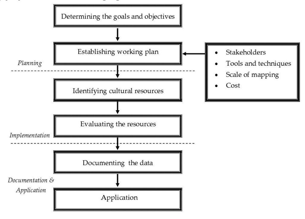
Figure 1. Steps for undertaking cultural mapping.
Sources: Adapted from Creative City Network of Canada (2010); Municipal Cultural Planning Incorporated (2010); and Pillai (2013)
The next step is to approach community members to identify unique cultural assets of a place. Jeannotte (2016) and Plieninger, Dijks, Oteros-Rozas & Bieling (2013) emphasize that local community knowledge is fundamental in deciding which cultural resources and stories best reflect the identity of a place. As argued by Azmi, Ali & Ahmad (2020), Puren, Drewes & Roos (2008) and Shamsuddin (2011), a long history of interaction and a strong interpersonal relationship through daily interactions with a place result in greater familiarity with a place, which in turn is central to developing locational knowledge. Exclusion of the local community will disassociate the attached community members from their familiar place, according to Ujang & Zakariya (2015). For Puren et al. (2008), involvement of locals is crucial so the past can be revived and incorporated into their surroundings and subsequently carried forward through time. Places that have been identified need to be evaluated to determine their cultural significance. According to Australia ICOMOS (2013), the assessment of cultural values is necessary to establish the significance and importance of a place, as it reveals new information and gives new insight into cultural places, especially those that have previously been overlooked.
The final stage of the cultural mapping procedure comprises the documentation of the collected data. This is important to achieve a better understanding of the place (Vileikis et al., 2012). The output may be in the form of inventories, cultural statistics, plans, maps, and even recommendations. The documented data can be further used to serve various purposes, such as sharing information about the cultural resources of a place with the community or municipality for the purpose of developing long-term planning. This is essential to ensure the integration of cultural resources across all facets of local government planning and decision making.
Methodology
This study adopted a case study approach as part of a quantitative research. The first stage of the study involved a systematic search of available literature on the concept, uses and approaches in conducting cultural mapping. An in-depth review of relevant journals, books and official documents published by government and private agencies provided the grounds for this study to explore the significance of cultural resource mapping as an important technique for identifying unique characteristics of a place. The review was subsequently complemented by a questionnaire survey among local residents in the small town of Sungai Lembing in the state of Pahang, Malaysia to investigate their mental representations of familiar features that they experience in the town, through cultural mapping. As argued by Shamsuddin (2011), places that are distinctive and are remembered vividly by the observer become part of the dominant elements that constitute a town's identity. While being recognized as an essential ingredient in cultural mapping, involvement of the local community is also important, as the activities surely create awareness and heighten appreciation for the uniqueness of their town (Assumma & Ventura, 2014; Fitri et al., 2017). This is crucial as they will always be the best stewards of the place (Global Heritage Fund, 2010).
Residents within the historic core of the town were selected randomly and the survey progressed street by street at a time convenient to them. From a database purchased from the Department of Statistics Malaysia, the total residential population who permanently reside within Sungai Lembing town consists of 385 inhabitants. Referring to the table provided by Krejcie & Morgan (1970), the minimum sample size of residents for this study was 196 at a confidence level of 95 percent and with an error estimate of 5 percent. In order to obtain a better response, the number of questionnaires distributed exceeded the actual sample size, where a total of 400 questionnaires were disseminated. However, the response rate was fairly low, with 108 responses, or 27.0 percent of the total number of distributed questionnaires. Following this, another 200 questionnaires were distributed and the number of questionnaires returned increased by 11. Hence, a total of 119 responses were obtained, representing a response rate of 19.8 percent with a margin of error of 7.5 percent.
In the survey, the participants were asked to draw the main features or places of interest in their town through a hands-on approach. Figure 2 shows an example of cultural mapping drawn by one respondent. According to Pillai (2013), this approach is more suited for small communities in small sites. In contrast with previous researches, where subjects were only given a sheet of blank paper, the participants in this study were provided with a map showing the town's main route. This modification was made, as the sketching task was skipped by the majority of potential respondents during a pilot survey. In addition to this, an example of a node or concentration point of the town, namely the main bus station, was added to the map to guide the respondents in conducting the mapping exercise (circled and marked as Example 1 in Figure 2). This was because many of the respondents were faced with difficulties in figuring out what to draw and how it should be drawn at the beginning of the study. Since some of the respondents were less-literate (8.4 percent), the researchers took quite some time to explain the purpose and type of data required for the mapping as well as to help them draw on the map.
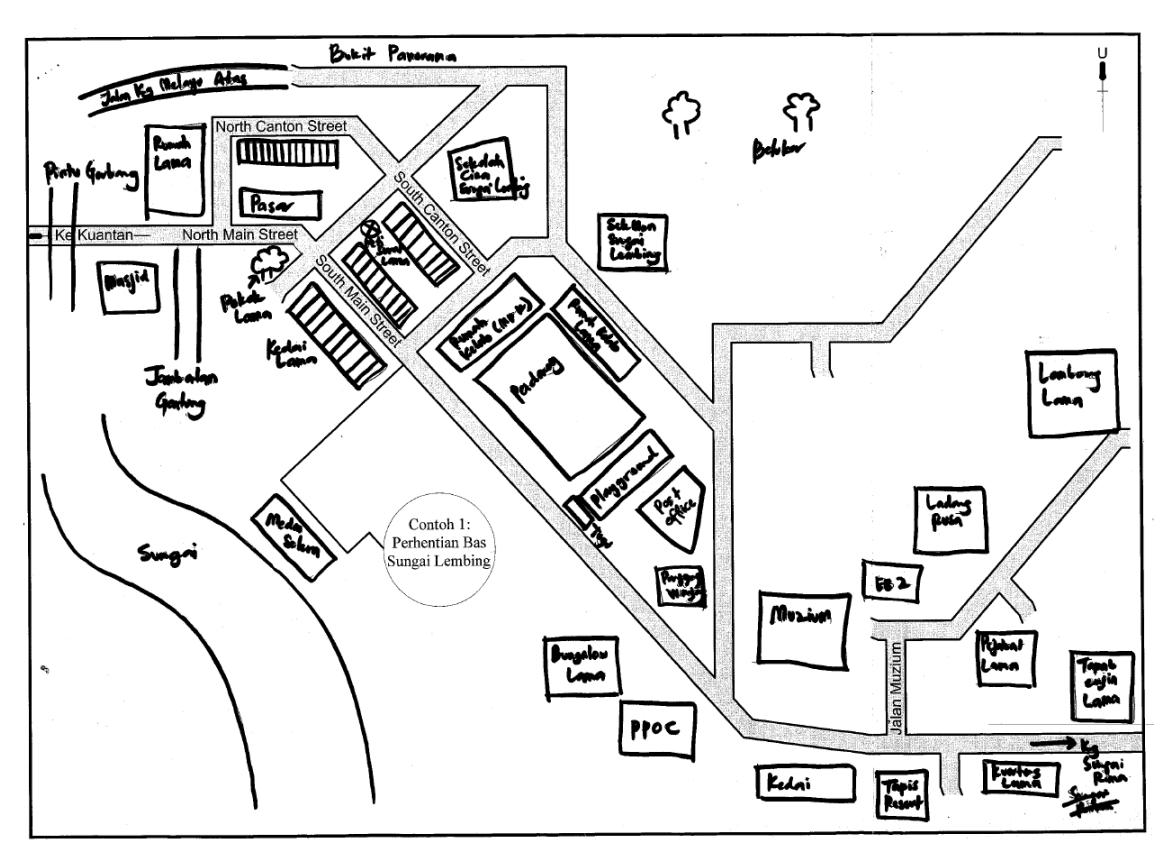
Figure 2. Example of a cultural map drawn by one respondent.
The data gathered in the survey was then analyzed according to the five elements of cities introduced by Kevin Lynch, namely paths, edges, nodes, districts and landmarks. These elements are remembered well by observers and thus are important in creating the identity of a place (Lynch, 1960). As argued by Pillai (2013), distribution of assets and resources that have an impact on cultural creativity need to be mapped and recorded for the purpose of analysis.
Since the emphasis of the study was on the mental image of the physical qualities that is held by individuals, Kevin Lynch's theory was applied because it emphasizes the component of identity and the structure of urban elements as two important factors affecting the imageability of a place. While seen as a precursor to many established researches, this method can also be used for the evaluation of significant local places (Lynch, 1960). It was anticipated that the findings would provide a platform for drawing attention of the respondents to distinct resources in their town, ultimately establishing its identity and uniqueness.
Background of the case study
Sungai Lembing is a small town in Pahang, the largest state in the Malaysia peninsula. While there is some consensus that the town was originally a Lim Beng settlement, named after Lim Beng (or Lim Ah San), the Chinese figure who developed the settlement, scholars have also suggested that the name Sungai Lembing could come from the word 'lembing' (spear), a hunting weapon used by the indigenous people to catch deer (Kuantan Municipal Council, 2013). It is believed that one day some people tried catch a deer in the forest. In an effort to save itself, the deer jumped into the river and disappeared, with the spear still sticking in its body. At the beginning of the 18th century, a group of tin miners who arrived in the area found a spear from hunters from the old days and since then it was named Sungai Lembing.
Mining activities have created the town more than 100 years ago and once commercialized on a large scale enriched the nation's economy, thus making Sungai Lembing renowned throughout the world. Sungai Lembing's days of glory were sparked off in 1906 when a British company known as Pahang Consolidated Company Limited (PCCL) started to operate what soon became the world's largest lode mine for tin. In its heyday, the town also enjoyed a vast array of amenities, including hospitals, schools, shops, a police station, residential areas, and a good transportation system.
Although it was once a wealthy tin-producing town, it is now a quiet settlement from a bygone era. It was went into decline immediately following the mine's closure in 1986. The closure of the mining infrastructure not only froze the town in time but also caused its neglect. Even today, its remoteness from other cities and its isolation from major highways keeps it a semi-inhabited ghost town with a few cores of permanent residents, most of whom are former miners who have chosen to remain and have a very proud identity rooted in the history of the mines. This small town, although looking a bit run-down, still bears the vestiges of the pre-war era. It silently holds many untold stories of the past that need to be studied further.
Original buildings have remained relatively intact and some are still used to date. The officers' mess, clerk's club, laborers' club, and the cinema are still standing. Quarters such as the Asian bungalow and Rumah Kongsi have become homes to former miners who have chosen to remain. Four old suspension bridges, for light traffic only, connect several villages to the town across the river. Also, one can still witness a solitary letter box from the British era in the commercial area. What is more interesting is the tin mining heritage, which is a potential tourist attraction (Pahang Town and Country Planning Department, 2010). Although some of the pits were closed for safety reason, the mine has been preserved in its natural and original setting. Visitors are able to experience the unique cooling climate in the tunnels, as the mine is located beneath a tropical rainforest. Both natural and man-made characteristics create a distinctive atmosphere in the town as a whole. The fact that Sungai Lembing acted as mining town strongly influences its characteristics. As argued by Shamsuddin (2011), the character of a place is very much influenced by the function of that place.
Results and Discussion
A range of unique places drawn by the respondents in the cultural mapping exercise is illustrated by red shading in Figure 3. They were able to identify the distinctiveness of Sungai Lembing following to their long familiarity with the place. Although most of them were not familiar with the technique, over 160 cultural resources were identified, as summarized in Table 1 and 2. The study also taught that, apart from communicating the purpose of the mapping exercise to the respondents, it is crucial to give detailed instructions on how to draw on the map, especially to less-literate respondents. As suggested by Pillai (2013), a mapping brief needs to be prepared prior to the exercise, which spells out the rationale for mapping, the type of data required, and how the data may serve present as well as future uses.
Fitri et al. (2017) suggest that having a dedicated enumerator from the area surveyed would greatly assist the effectiveness of the mapping exercise. Taking the basis from the previous study conducted by Shamsuddin (1997) on the town center of Kuantan, the list of elements in Table 1 includes only places that were actually drawn by at least 10 percent of the respondents. On the other hand, the remaining places drawn by less than 10 percent of the respondents are listed in Table 2. As discussed in the methodology section, the sketched maps drawn from memory by the respondents were analyzed according to the five city elements introduced by Kevin Lynch. Of the five city elements, only the district was not drawn by any respondents in the town. A plausible explanation is that the town itself is perceived as a district. This result corresponds to that of Shamsuddin (1997), who found that only nodes, edges, landmarks and paths were drawn by the respondents in structuring the town center of Kuantan in Pahang.
Figure 3. Distribution of the identified cultural places in Sungai Lembing town.
Table 1. List of Elements Drawn in Mental Maps by At Least 10 percent of Respondents
| Elements/ places | Path | Edge | Node | Landmark |
|---|---|---|---|---|
| Museum | - | - | - | 69.4 |
| Football field | - | - | 67.3 | - |
| Labor club | - | - | - | 59.2 |
| Shophouses | - | - | - | 38.8 |
| Former English school | - | - | - | 36.7 |
| Police station | - | - | 34.7 | |
| Post office | - | - | - | 32.7 |
| Mine | - | - | 30.6 | - |
| Old cinema | - | - | - | 26.5 |
| PPOC building | - | - | - | 26.5 |
| Playground | - | - | 22.4 | - |
| Secretary Club | - | - | - | 20.4 |
| Gateway | - | 20.4 | - | - |
| Sungai Lembing mosque | - | - | - | 18.4 |
| Medan Selera | - | - | - | 18.4 |
| Panorama Hill | - | - | - | 18.4 |
| Tapis Resort | - | - | - | 16.3 |
| Kolong Pahat hanging bridge | - | - | - | 16.3 |
| SRJK © Sungai Lembing | - | - | - | 16.3 |
| Wet market | - | - | 16.3 | - |
| European bungalow II | - | - | - | 14.3 |
| Engine site | - | - | - | 12.2 |
| Gerai PLB | - | - | - | 12.2 |
| PCCL Headquarter | - | - | - | 10.2 |
| Asian bungalows | - | - | - | 10.2 |
| Kampung Melayu | - | 10.2 | - | - |
Table 2. List of Elements Drawn in Mental Maps by Less Than 10 Percent of Respondents
| Elements/ places | Path | Edge | Node | Landmark |
|---|---|---|---|---|
| Rumah Kongsi | - | - | - | 8.2 |
| Mature trees | - | - | - | 8.2 |
| Solitary letter box | - | - | - | 6.1 |
| Former hospital site | - | - | - | 6.1 |
| Library | - | - | - | 6.1 |
| Deer farm | - | - | 6.1 | - |
| Kenau River | - | 6.1 | - | - |
| Kampung Seberang bridge | - | - | - | 6.1 |
| Memorial | - | - | - | 4.1 |
| Former ore factory site | - | - | - | 4.1 |
| Former school site | - | - | 4.1 | |
| Crystal House | - | - | - | 4.1 |
| Kampung Sungai Rimau | - | - | - | 2.0 |
| Homestay Panorama | - | - | - | 2.0 |
| Chinese temple | - | - | - | 2.0 |
| Basketball court | - | - | 2.0 | - |
| Jalan Kampung Melayu Atas | 2.0 | - | - | - |
Since the major roads of the town were shown in the map given to the respondents, the number of elements drawn as a path was very small, as shown in Table 2. Only Jalan Kampung Melayu Atas was added by 2 percent of respondents who had stayed in the town for more than 5 years. As argued by Lynch (1960), people who know a place better have usually mastered and are more familiar with the path structure. The path was noted because of its role as an important alternative road that eases the flow of traffic on the main road of Jalan Besar regardless of its narrow width and poor condition.
The cultural mapping survey further revealed that there were three types of edges drawn by the respondents, particularly natural features, housing areas and non-building structure such as the gateway. As stated by Rapoport (1977), understanding people's perceptions regarding the boundaries of a place is essential in establishing place identity. Table 1 shows that the gateway was drawn by the majority of respondents (20.4%) to delineate the town limits. Apart from the size, billboards and lighting system installed, the importance of this gateway as an edge is also signified by its strategic location at the town's only entrance to the north. The mapping exercise revealed the significance of location in strengthening the image of a place. In contrast, natural features, particularly Kenau River (6.1 percent), were drawn by the smallest number of respondents to demarcate the boundaries of Sungai Lembing town, as shown in Table 2. This is most probably because of the shallowness of the water as well as the absence of direct views of the river from the main road of Jalan Besar, which runs parallel to it, thus making the river unobtrusive. The river, however, is consistent with the western boundary of the town proposed by the Kuantan Municipal Council. This essentially suggests the clarity of the character of the river in the respondents' minds. While it serves as a strong edge to the town, the importance of natural elements for the imageability of a place cannot be denied (Shamsuddin, 2011).
The presence of nodes was also analyzed from the sketched maps. Based on Table 1, the football field was the most frequently element drawn as a node for Sungai Lembing town, with 67.3 percent of the respondents. From the survey it was found that the football field is important to the locals as a favorable place for both recreational activities and social interactions. This implies that in explaining the distinctiveness of a place, one should be looking both for the presence of physical elements and the spirit that gives life to such characteristics. As argued by Pillai (2013), mapping helps people to understand the connectivity between the items being mapped and values that underlie them. Its character was also signified by the presence of historical buildings surrounding the field, such as the former laborer's and clerk's clubs. This result confirmed Lynch's (1960) notion that nodes become memorable when they are supported by a strong physical form. A children's playground located just a stone's throw to the south of the football field was also drawn by 22.4 percent of respondents. Notwithstanding this fact, it was observed that the mine stands out more prominently, as it was drawn by the second highest number of respondents (30.6 percent). Its tourist function makes the mine the liveliest place in the town. In its Special Area Plan, Sungai Lembing town was dubbed a Tourism Heritage Town. Another major node drawn in the town is the wet market or Pasar Cina (16.3 percent), as it is commonly known for its liveliness with activities from dawn to afternoon. The findings are in line with Lynch (1960), who states that nodes often gain their importance from being the concentration of some use or activities. Human activities and physical settings reinforce each other to create a vivid presence. Relph (1976) and Shamsuddin (2011) however argued that the impact of activities tends to be prominent only when the physical form manages to provide a context and enhances the manifestations of those activities.
From the sketched maps it was also observed that landmarks played an important role in structuring the town's area. Table 1 and 2 show that places drawn as landmarks comprised
buildings, monuments, natural features, bridges and a surprisingly bare area of land that somehow has significance to some of the respondents. As argued by Cabeca (2018), Caquard & Cartwright (2014) and Crawhall (2009), mapping make the invisible become more visible and tangible. Among these places, buildings are the elements most commonly drawn and used as landmarks. The Sungai Lembing Museum (Figure 4) was the most consistently landmark drawn on the map, by 69.4 percent of respondents. While being a fine example of the vernacular colonial architecture, the museum is also clearly visible and distinguishable due to its location on top of a hill that overlooks the surrounding settlement areas and is thus visible from lower lying areas in the town. Apart from its aesthetic significance, the museum also plays an important role as a major tourist attraction in the town. Other buildings drawn as landmarks by more than half of the respondents in Sungai Lembing were the laborer's club, by 59.2 percent of respondents. This is in line with Fitri et al. (2017), who found that buildings were the elements that were most frequently mapped.
Apart from buildings, the mapping also indicated other man-made features, particularly the hanging bridges, a memorial stone and the letter box, that tend to be used as landmarks within the town's areas. This result confirms Lynch's (1960) notion that physical objects that are visible only in restricted localities or from certain approaches can also be reference points and fill in the image of observers. The hanging bridges, in Malay called jambatan gantung, were the highest non-building structure drawn by the respondents (16.3 percent). There are two hanging bridges located at Kampung Seberang and Kampung Kolong Pahat (Figure 5). Now more than 100 years old, the latter is thought by locals to be the most unique bridge in Sungai Lembing and the opportunity to walk across the bridge should not be missed. This hanging bridge is a fabulous place that is rarely found in any other place, thus contributing to the town's identity. Apart from being a popular tourist attraction, it also provides convenient access for locals between Kampung Kolong Pahat and the town area. Therefore, it can be regarded as one of the major paths in town although its importance as a path is not that significant compared to the roads.
Figure 4. Sungai Lembing Museum.
Figure 5. Kolong Pahat hanging bridge.
In addition to distinctive man-made elements, the importance of distinctive natural features in promoting a town cannot be denied, as they were also drawn by the respondents as unique characteristics of Sungai Lembing. As shown in Table 1, Panorama Hill was drawn by 18.4 percent of respondents as a backdrop to the town. The hill is believed to significantly influence the quality of the view and overall profile of the town. Further to this, many of the mature trees drawn (8.2 percent), especially within the vicinity of the commercial area of the town, not only provide shade to the area but also act as important landmarks due to their visibility from afar. For respondents, the presence of these heritage trees also complements the built heritage in giving the town a nostalgic feeling. Hence, the results of the cultural mapping revealed that mental pictures carried by the town's inhabitants are not only confined to historic buildings but also encompass natural features. These features not only offer interesting views and a tranquil quality to the town but also enrich people's sensory experiences by providing a context for wide ranges of outdoor activities.
Conclusion
By employing cultural mapping for the identification of distinct characteristics of a small-scale town, this paper is hopefully the first of many fruitful contributions that exemplify the importance of using this tool at the local level. A large number of local cultural places identified through cultural resource mapping reflect the importance and significance of the tool in identifying unique features and the identity of a place, especially those that have previously been overlooked. This is undeniably important to highlight the significance of a small town's uniqueness for a balanced notion of place in the field of heritage studies. In particular, the identified cultural elements that relate to the attributes of identity and structure in the mental image of the town's inhabitants encompass buildings, non-building structures, spaces, landscape, and natural features. Although they also noticeably follow qualities that are subsumed in uses, meanings, and memories, physical features appear to be more imageable and evoke a stronger image in the inhabitants. The physical characteristics of a place reinforce and manifest intangible aspects of culture and hence people are more inclined to map tangible items first. Throughout the mapping exercise, the study was confronted with respondents who were less-literate and unfamiliar with the method. Initially, some of the respondents failed to figure out what to draw and how it should be drawn on the map, so that the study took a long time to complete. These limitations provided an opportunity for this study to make recommendations for future mapping exercises, including the preparation of a detailed mapping brief for the community, involvement of a dedicated and well-trained enumerator in the team, and the use of digital tools and techniques for data recording and analysis. This would greatly enhance the effectiveness and efficiency of the mapping exercise, particularly in terms of time and resources. While enabling identification of potential cultural resources in a place, the information obtained from mapping also serves as an invaluable resource for the formulation of policies that embody a sensitive analysis of people and places, and most importantly ensure that all local cultural resources valued by the communities are considered. In this case, cultural mapping is seen as a tool that allows planners to understand a place and collective memories that people associate with that place using the perspective of local society. This is crucial, as poorly planned towns threaten individuals' relationships with the place and ultimately lead to a loss of place identity. Therefore, the practice of cultural mapping is vital for towns, cities, regions, or more generally places, to grow and prosper.
Acknowledgement
This work was supported by the University of Malaya, Institute of Research Management and Consultancy (IPPP) [grant number PG003-2012B].