
Introduction
Java, the 13th largest island in the world, is the most densely populated big island in the world. With a population of more than 145 million according to the latest inter-census survey (Statistics Indonesia, 2015), Java has an average population density of 1,120 inhabitants/km2 , which is very much higher than those of other big islands in the world. Java is also the smallest of the five big islands of Indonesia. Its land area is about 7% of the total land area of the country, while it is the home to about 57% of the national population (Statistics Indonesia, 2015), 62.6% of which is urban population, representing 67% of the urban population of the country. From 1971 to 2010, the urban population of Java grew with 66.2 million people (68% from the national). The high density and rapid growth of the urban population has transformed Java into fertile ground for urbanization and urban growth. In addition to being the home of Jakarta, the largest city in Indonesia, Java also has six other of the ten largest cities in Indonesia and is also the home of 30 of 94 cities in Indonesia with a population size ranging from 125,000 to ten million per city (Rahayu and Mardiansjah, 2019). One of the results of its very high population density is that the urbanization process in Java is highly characterized by sprawl and extension of urban areas from the core cities to the surroundings. Today, these processes also characterize the growth of small and medium cities in Java, replicating the processes that occurred several decades ago in much bigger cities, especially in Jakarta, Surabaya and Bandung, the three largest cities.
Ginsburg (1991) and McGee (1991) argue that extended urbanization has become an important characteristic in the spatial process of urbanization in many developing countries, which is very different to the process that took place in western cities. However, they both have a different view on the process, as Ginsburg (1991) sees it as a process of urbanization of the countryside, while McGee (1991) sees it as a process of continuous urbanization in a space-economy transition between urban and rural areas. In Java, the extended urbanization process started in the 1980s with the emergence of extended metropolitan regions around its largest cities (Firman, 2003). This was characterized by slowing urban population growth in existing cities, which became urban cores, accompanied by increasing urban population growth in their surrounding areas, which usually belonged to the territory of surrounding kabupaten (non-urban districts).
Today, in Java, the extended spatial process does not solely occur in large cities. It also characterizes the urbanization process of many other cities in Java, including intermediate and smaller cities. Mardiansjah (2013) has shown this process in the surroundings of Malang City, an intermediate city in Java with a population of nearly one million. Mardiansjah, Handayani and Setyono (2018) and Pradoto et al. (2018) presented this phenomenon in Surakarta, a city with half a million inhabitants. Fahmi et al. (2014) and Mardiansjah (2020) have shown the cases of Cirebon and Tegal, much smaller cities with a population of 200,000 to 300,000 respectively.
This paper discusses urban growth in much smaller cities of Java, using the case study of Tegal, Pekalongan and Magelang in Central Java. As their administrative areas are limited, the three cities have experienced sprawl and expansion of their urban areas. In order to obtain a better understanding of their urban growth, this study analyzed the development of towns in the surrounding kabupaten of the three cities. We expected to learn how urban areas grow out of small cities into surrounding areas.
In urban studies, more attention needs to be given to small cities, especially those located in highly dense populated regions like Java. Small cities play an important role in the world urbanization process and many of the largest cities grew from small cities only some decades or a century ago (Cohen 2006; Cohen 2004). Research on small cities is also important because most urban theories are based on researches on large and major cities (Bell and Jayne, 2009). This paper aims to contribute to this discussion by providing evidence on small-town growth and development, especially from the perspective of Java, a place in a developing country with a high population density.
The findings support Cohen's (2006) argument on the importance of small cities in urban discourse, as they also face rapid urbanization. Moreover, the limited administrative areas provide an ecosystem where urban growth in regions with a high population density will inevitably involve the expansion of existing urban areas, either through outward spread or by merging with existing concentrations in peripheries that are also growing and strengthening. The case of Java shows that the rapid growth of small cities has made certain cities capable of increasing the urban concentration in their peripheries with a population size equivalent to that of the city itself within only a few decades. This evidence provides reasons for small cities in developing countries to give proper attention to improving their capacity in managing the extended urbanization process in collaboration with their surrounding localities.
Urbanization, Peri-urbanization and Small Towns Growth in Developing Countries
Urbanization, a complex and phenomenal transformation that involves social, economic, spatial, physical, cultural and political changes, can be considered as a transformation process from ruralness to urbanness that is reflected in socio-economic and spatial-physical changes in the area (Firman, Kombaitan and Pradono, 2007). This process is one of the most important phenomena that has been changing the world since the last half of the previous century (UN, 2019). One of the most important aspects in urbanization is the fact that its process in developing countries is very different than in the developed world (Cohen, 2004). Firman (2004) emphasizes that the process in developing countries occurs at a lower level of income per capita and in a totally different global situation, making it harder for the cities to compete in order to gain benefit from global economic activities. Meanwhile, Cohen (2004) argues that the main difference comes from several aspects, such as the large and unprecedented scale of the urban population involved in the process, the rapid change of urban growth, and the global environment impacting urban change today.
In addition to its large scale and rapid growth, one of the most important distinct characteristics of urbanization in developing countries, especially in Asia, is its extended spatial process, which brings urban growth into areas beyond intended city limits, which creates extended urban formation with stronger spatial integration between cities and their surrounding areas (Ginsburg, 1991; McGee, 1991). Links and connectivity between urban and rural activities are created, and technological development, especially in transportation and communication, improves the possibility of urban-rural integration in the new spatial paradigm, and also among urban cores in cities and their surrounding areas, which allows many urban dwellers to live in the peripheries without losing their jobs in the city (McGee, 1991). Later, enhancement of telecommunication and information technologies improved connectivity by facilitating the circulation of commodities, people, ideas as well as capital in the region, which strengthens the role of urban centers outside the city (McGee, 1991; Ginsburg, 1991). These trends make it possible for many industrial activities to move to the peripheries, as they still have good connectivity to their relations in the city while they have access to cheaper land, labor and agricultural products as inputs for their production process. These trends also improve the possibility for rural households to get urban jobs and other income generating activities without having to move their residency to the city, including doing some agro-processing of their agricultural products in order to serve the needs of urban households and their activities in the city. These situations improve links and interactions between rural/village production systems and those from urban centers in the region (Ginsburg, 1991; McGee, 1991).
The spatial reflection of the extended urbanization process also reveals that the city-hinterland relationship is becoming a more integrative relationship among city or urban areas and rural areas. The emergence of the spatial extension of urban areas brings considerable justification for periurban areas created outside the city core and adjacent contiguous built-up areas that may extend for a distance of up to 100 km from the city core (McGee, 2005). McGee (1991) initiated the development of this definition with his concept of desakota, consisting of two sub-regions in a metropolitan region labeled as peri-urban and desakota, each with spatial features that show different mixes of peri-urbanization. McGee (1991) defines desakota as densely populated areas adjacent to peri-urban areas that usually surround an urban core. In this context, McGee (1991) defines desakota as the extension of peri-urban areas, which can be seen as non-urban areas and are a unique part of a metropolitan area, where urban and agricultural features and activities are mixed together, blurring the distinction between them. In addition, McGee (1991) states that periurban areas are the areas surrounding a city within daily commuting reach of the city core, where the distance of the daily commute can vary for every region, depending on their space-economy transition area.
McGee (1991) also questioned the distinction between desakota and peri-urban areas: "If these zones (i.e. desakota) are simply a greater areal extension of the 'peri-urban' region of large cities that have been brought about by space-time collapse and transportation improvements, then what is different about them (i.e. desakota) from the so called peri-urban regions?" However, the concept of desakota has helped to force a redefinition of the traditional conception of rural-urban distinctions and relations into a more integrative concept (Simon, McGregor and Thompson, 2006). Later, peri-urban areas were defined as transitional zones between the city and the countryside where urban and rural activities meet and are mixed and combined together in the same place, creating a unique system of activities that vary as a result of the combination of the two types of activities (Adell, 1999). Especially for developing countries, Friedmann (2011) defines peri-urban areas as zones of encounter, conflict and transformation toward surrounding cities, where innovations and adaptation of mixed urban and rural activities occur in response to emerging realities. Leaf (2011) differentiates between peri-urban and suburban areas, as he argues that peri-urbanization is the expansion of an urban administrative structure into previously rural settings, which creates intermixing of urban and rural activities in the same place, improving its potential as a place for the emergence of new forms of interaction in social, economic and environmental aspects of the areas involved. This brings different meanings and situations to suburbanization and creates more exclusive zones of urban functions (Firman, 2016).
As more densely populated areas in peri-urban areas, which have transportation hubs as well as social and economic facilities, desakota are service centers that stimulate more interaction between the city center and the rural hinterland. Thus, they make possible the improvement of social and economic linkages between the urban core and its peripheries and strengthens the role of rural centers in the peripheries (McGee, 1991; Ginsburg, 1991). Therefore, the existence of peri-urban areas and desakota is important in the spatial development of urban processes. Their importance is not only derived from their function as places where intensive rural-urban interaction occur (McGee, 1991; Ginsburg, 1991), but also from their ability to accommodate the pace and characteristics of socioeconomic changes in the urbanization process in the region. These potentials make them places that can subsequently grow as urban centers that become part of an emerging larger urban area (McGee, 1991; Ginsburg, 1991). In this context, Leaf (2011) argues that peri-urbanization can also be seen as part of the effort of regulating the urbanization process in order to make villagers' spontaneous development activities more in line with laws and regulations, thus calling peri-urbanization an effort to "civilize the countryside".
Data and Methods
This study attempted to gain a better understanding of the growth of small cities by analyzing the urban growth in the peri-urban areas of three smaller cities in Central Java, which form small urban regions together with the cities that serve as core areas. The cities are Kota (city) Tegal, Kota Pekalongan and Kota Magelang. Kota Tegal is a city with a population of about 250,000. It has two bordering kabupaten as peripheries, i.e. Kabupaten Tegal and Kabupaten Brebes. Most of the areas of the kabupaten are in a range of about 50 km from the city. Kota Pekalongan is a city with a population of about 300,000. It also has two bordering kabupaten, i.e. Kabupaten Pekalongan and Kabupaten Batang, with most of the area within a radius of 60 km from the city. These two urban regions are located in the corridor of the North Coastal National Road (Jalan Nasional Pantai Utara or Pantura) of Central Java, which is part of the most important regional access route in the country, which connects all major cities on the northern coast of Java, including Jakarta in the west, Semarang in the center and Surabaya in the east. From Semarang, the capital of the province, Kota Tegal is about 150 km to the west, while Kota Pekalongan is about 90 km in the same direction. The two urban regions are separated by Kabupaten Pemalang, which is also located along the national road and lies between the two urban areas, so Pemalang can also be seen as a transitional area of the two urban regions. Meanwhile, Kota Magelang, a city with a population of about 120,000, is located inland about 80 km south of Semarang. The city is surrounded by Kabupaten Magelang.
This study defines towns that are formed in the process of urbanization as agglomerated urbanized villages within kabupaten territory. Therefore, the identification of small-town growth utilized the urban village classification used by Statistics Indonesia (BPS, Badan Pusat Statistik) on all villages in the kabupaten. Usually, BPS classifies villages into two categories, i.e. urbanized and non-urbanized villages. This study used the urban village classification for 1990, 2000, 2010 and 2017. The first three time points are the time of the Indonesian population census, while the last time point was used to show the latest situation. The towns identification assumes that adjoining urbanized villages in the same kecamatan, a sub-division of kabupaten, have agglomerated into the same town. Therefore, this paper sees adjoining urbanized villages located in different kecamatan as forming different towns. Urbanized villages that are not located adjacently are assumed to form different towns too, even when they are located within the same kecamatan. Furthermore, as the towns are formed by agglomeration of adjacent urbanized villages, their borders are formed by the borders of the villages too. The size of the towns, as discussed in Section 4.3, was counted by enumerating the populations of the agglomerated urbanized villages.
Result and Discussion
Urban population growth in the peri-urban areas of the small cities
As shown in Table 1, the three urban regions have experienced a high increase of the urban population, even though the growth of their total population was only moderate. Among the three, Tegal Urban Region was the region with the highest urban population increase, while Magelang
Urban Region was the one with had the lowest. It is interesting to see that urban population growth outside the cities' administrative areas, i.e. within the territory of the kabupaten, was much higher than of that in the cities themselves.
Table 1 also shows that Tegal Urban Region had the largest total population among the three regions, as the two surrounding kabupaten had a larger population than the other observed kabupaten in this study. Table 2 shows that the higher population of Tegal Urban Region is due to its area, which is larger than that of the other regions. In addition, Tegal Region is also becoming the most densely populated region among the three regions, even though the three regions, including Kabupaten Pemalang, always had relatively similar levels of population density and Magelang Urban Region was the most densely populated region in the 1980s.
Table 1. Growth of Total and Urban Populations in the Three Urban Regions, 1980-2010
| Regions / Areas | Population Sharing | ||||||
|---|---|---|---|---|---|---|---|
| 1980 | 1990 | 2000 | 2010 | (%) | |||
| Total Population | |||||||
| Tegal Urban Region | 2,495,365 | 2,990,899 | 3,316,119 | 3,368,307 | 100 | ||
| - Tegal City | 131,440 | 229,713 | 236,900 | 239,599 | 7.1 | ||
| - Kabupaten Tegal | 1,099,937 | 1,239,351 | 1,382,435 | 1,394,839 | 41.4 | ||
| - Kabupaten Brebes | 1,263,988 | 1,521,835 | 1,696,784 | 1,733,869 | 51.5 | ||
| Kabupaten Pemalang | 945,418 | 1,114,228 | 1,261,454 | 1,261,353 | |||
| Pekalongan Urban Region | 1,314,475 | 1,534,331 | 1,721,562 | 1,826,819 | 100 | ||
| - Pekalongan City | 132,413 | 242,874 | 262,272 | 281,434 | 15.4 | ||
| - Kabupaten Pekalongan | 651,645 | 699,810 | 798,186 | 838,621 | 45.9 | ||
| - Kabupaten Batang | 530,417 | 591,647 | 661,104 | 706,764 | 38.7 | ||
| Magelang Urban Region | 1,058,106 | 1,139,085 | 1,217,796 | 1,299,950 | 100 | ||
| - Magelang City | 123,358 | 123,213 | 117,531 | 118,227 | 9.1 | ||
| - Kabupaten Magelang | 934,748 | 1,015,872 | 1,100,265 | 1,181,723 | 90.9 | ||
| Urban Population | % Urban | ||||||
| Tegal Urban Region | 502,061 | 1,012,893 | 1,543,807 | 1,800,862 | 53.5 | ||
| - Tegal City | 131,440 | 229,713 | 236,900 | 239,599 | 100 | ||
| - Kabupaten Tegal | 262,375 | 494,077 | 755,651 | 811,372 | 58.2 | ||
| - Kabupaten Brebes | 108,246 | 289,103 | 551,256 | 749,891 | 43.2 | ||
| Kabupaten Pemalang | 207,120 | 312,688 | 615,793 | 636,977 | 50.5 | ||
| Pekalongan Urban Region | 341,164 | 586,588 | 836,237 | 1,001,608 | 54.8 | ||
| - Pekalongan City | 132,413 | 242,874 | 262,272 | 281,434 | 100 | ||
| - Kabupaten Pekalongan | 138,470 | 190,109 | 355,879 | 433,530 | 51.7 | ||
| - Kabupaten Batang | 70,281 | 153,605 | 218,086 | 286,644 | 40.6 | ||
| Magelang Urban Region | 221,462 | 291,110 | 398,438 | 449,731 | 34.6 | ||
| - Magelang City | 123,358 | 123,213 | 117,531 | 118,227 | 100 | ||
| - Kabupaten Magelang | 98,104 | 167,897 | 280,907 | 331,504 | 28.1 | ||
Source: Extracted from census data, 1990, 2000, 2010 and 2010
In terms of kabupaten, there were only three, i.e. Tegal, Pemalang and Pekalongan, which had an average population density level higher than 1,000 inhabitants/km2 , although the last two kabupaten could be considered as only recently having reached that level of average population density, while Kabupaten Tegal has had that level for decades.
Detailed observation of the data presented in Table 1 reveals spatial and temporal variation in the urban growth of the three small cities. Although they experienced a similar development, where urban population growth in the peripheries was much higher than in the urban core, the table shows that they had a different pace of growth, where Tegal Urban Region had the most rapid growth and Magelang Urban Region had the lowest.
In addition, from a temporal perspective, Tegal and Pekalongan Urban Regions experienced the most rapid urban population growth in the 1980s, which then decreased sharply in the following periods. Meanwhile, Magelang Urban Region had the 1990s as the period with the most rapid growth, even though its highest growth rate was not as high as that of Tegal and Pekalongan, and its period with the lowest growth rate was the same as for the other two urban regions, i.e. from 2000 to 2010.
Table 2. Growth of Population Density in the Three Urban Regions, 1980-2010
| Regions / Areas | Area | Population Density (inhab/km2 ) | |||
|---|---|---|---|---|---|
| (km2) | 1980 | 1990 | 2000 | 2010 | |
| Tegal Urban Region | 2,817.8 | 885.6 | 1,061 | 1,177 | 1,195 |
| - Tegal City | 39.7 | 3,312.5 | 5,789 | 5,970 | 6,038 |
| - Kabupaten Tegal | 876.1 | 1,255.5 | 1,415 | 1,578 | 1,592 |
| - Kabupaten Brebes | 1,902.0 | 664.6 | 800 | 892 | 912 |
| - Kabupaten Pemalang | 996.1 | 949.1 | 1,119 | 1,266 | 1,266 |
| Pekalongan Urban Region | 1,669.7 | 787.2 | 919 | 1,031 | 1,094 |
| Pekalongan City | 45.0 | 2,942.5 | 5,397 | 5,828 | 6,254 |
| - Kabupaten Pekalongan | 836.1 | 779.4 | 837 | 955 | 1,003 |
| - Kabupaten Batang | 788.6 | 672.6 | 750 | 838 | 896 |
| Magelang Urban Region | 1,103.9 | 958.6 | 1,032 | 1,103 | 1,178 |
| - Magelang City | 18.1 | 6,807.8 | 6,800 | 6,486 | 6,525 |
| - Kabupaten Magelang | 1,085.7 | 860.9 | 936 | 1,013 | 1,088 |
Source: Result of analysis, 2020
Rapid urban population growth, especially in the peripheries of urban regions, slowly changes the character of a region by increasing its urbanization level. The three urban regions, whose urbanization level was 20%, have changed into more urbanized regions. Tegal and Pekalongan Urban Regions had an urbanization level of almost 55% in 2010, while for Magelang Urban Region it was 35% during the same time. This means that more than half of the population in the first two urban regions was classified as urban population, as they lived in urban areas in the regions. Moreover, in terms of kabupaten there were three, i.e. Kabupaten Tegal, Kabupaten Pekalongan and Kabupaten Pemalang, that had more than half of their population living in urban areas within their administrative territory, with Kabupaten Tegal as the kabupaten with the highest level of urbanization, i.e. 58.17% in 2010. These conditions indicate that the growing urban areas in the kabupaten also had locational variation of urban growth of small cities.
Urbanized Villages Development in the Peri-urban Areas of the Small Cities
Identification of urban areas growing in the peripheries of urban regions starts with observing the growth of urbanized villages, i.e. villages that have been classified as urban villages by Statistics Indonesia in 1990, 2000, 2010 and 2017. It is a pity that we cannot access the required data for the year of 1980 since the data has not been digitalized yet, and they are not available at the office of Statistics Indonesia. For the classification, Statistics Indonesia assigns weights and classifies each village based on their score using three criteria, i.e. the population density of the village, the percentage of agricultural households in the village, and the availability of urban facilities in the village or at a certain distance from the village (BPS, 2010). The development of urbanized villages can be seen in two serial figures on the following pages, i.e. for Tegal Urban Region and Pekalongan Urban Region in the first figures, and for Magelang Region in the second figure. In addition, the growing number of urbanized villages in the observed regions is presented in Table 3. As explained before, Kabupaten Pemalang was analyzed individually, as this kabupaten is a transitional area between Tegal Urban Region and Pemalang Urban Region.
Table 3. Development of Urbanized Villages in the Three Urban Regions, 1990-2017
| Regions | 1990 | 2000 | 2010 | 2017 |
|---|---|---|---|---|
| - Tegal Urban Region | 141 | 130 | 246 | 247 |
| - Kabupaten Pemalang | 32 | 32 | 88 | 88 |
| - Pekalongan Urban Region | 79 | 103 | 180 | 181 |
| - Magelang Urban Region | 20 | 21 | 52 | 52 |
| Total | 272 | 286 | 566 | 568 |
Source: Result of analysis, 2020
Figures 1 and 2 show that there are different types of spatial growth of urbanized villages between Tegal Urban Region and Pekalongan Urban Region. Tegal Urban Region, shown on the left side of the maps, had more massive development of urbanized villages since the beginning of the observation period in 1990 compared to the other regions. This is because, as shown in Table 3, the region had the largest number of urbanized villages from that time onward. At the time, the urbanized villages in Tegal Urban Region were mainly concentrated in the areas that form an inverted-capital-letter-L-shape along two regional corridors, i.e. the provincial road from Tegal City to Slawi, the capital of Kabupaten Tegal, which is located about 15 km in the southern periphery of the city, and Pantura Road from Kota Tegal to Brebes, the capital of Kabupaten Brebes, which is located at about the same distance in the western periphery. Outside the inverted L-shaped area, the urbanized villages are scattered in some capitals of kecamatan, mostly in Kabupaten Tegal along the provincial road to the south, while urbanized villages in Kabepaten Brebes were less developed than in Kabupaten Tegal.
Meanwhile, in Pekalongan Urban Region, which still had 79 urbanized villages in 1990, about half the number of today, the development of urbanized villages in 1990 was less concentrated compared to the development in Tegal Region during the same period. Most of the urbanized villages in this region were located in Kabupaten Pekalongan, i.e. in the south of the city. Especially for those in Kabupaten Batang the development of urbanized villages was still scattered in some places, mainly in certain parts of the capitals of kecamatan located along Pantura Road. The low development of urbanized villages in Kabupaten Pekalongan is considered to be influenced by the location of its capital, which used to be in Kota Pekalongan but was recently moved outside the city to Kecamatan Kajen in 2001.
Meanwhile, the development of urbanized villages in Kabupaten Pemalang, the transitional area between Tegal Urban Region and Pekalongan Urban Region, was more dynamic compared to that in Kabupaten Pekalongan or in Kabupaten Batang. The dynamics of urbanized village development in Kabupaten Pemalang in 1990 was relatively similar to that in Kabupaten Tegal. In addition to the influence of its location along the Pantura Road corridor, we can consider that the development in this kabupaten was also influenced by the constellation of urban concentrations in it. As can be seen, the concentration of urbanized villages in Kabupaten Tegal in 1990 was located between Kota Tegal and Slawi, the capital of Kabupaten Tegal. This is considered to be influenced by the location of the capital of the kabupaten, which was also the largest urban concentration in the kabupaten, located about 15 km from Kota Tegal. The distance eases interactions between the two urban concentrations, which also had a positive influence on the areas in between, giving them more potential to grow than other areas.
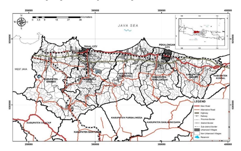
Figure 1. Urbanized villages in Tegal and Pekalongan Urban Region, in 1990.
In the case of Kabupaten Pemalang, the location of its capital Kecamatan Pemalang, which was also the largest urban concentration in the kabupaten from that time until today, is located at less than 35 km from Kota Pekalongan. This had a positive effect on the growth of certain villages, especially those located in the Pantura Road corridor between the city and the capital. This situation is very different from that of Kabupaten Batang, where its capital Kecamatan Batang is also the largest urban concentration in the kabupaten and is located right next to Kota Pekalongan. In the case of Batang, the location could not induce rapid growth of urbanized villages because of its proximity, despite being located in the Pantura Road corridor.
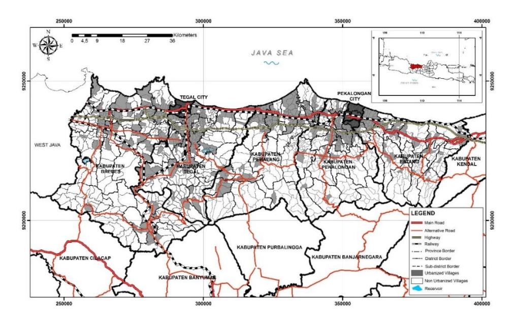
Figure 2. Urbanized villages in Tegal and Pekalongan Urban Region, in 2017.
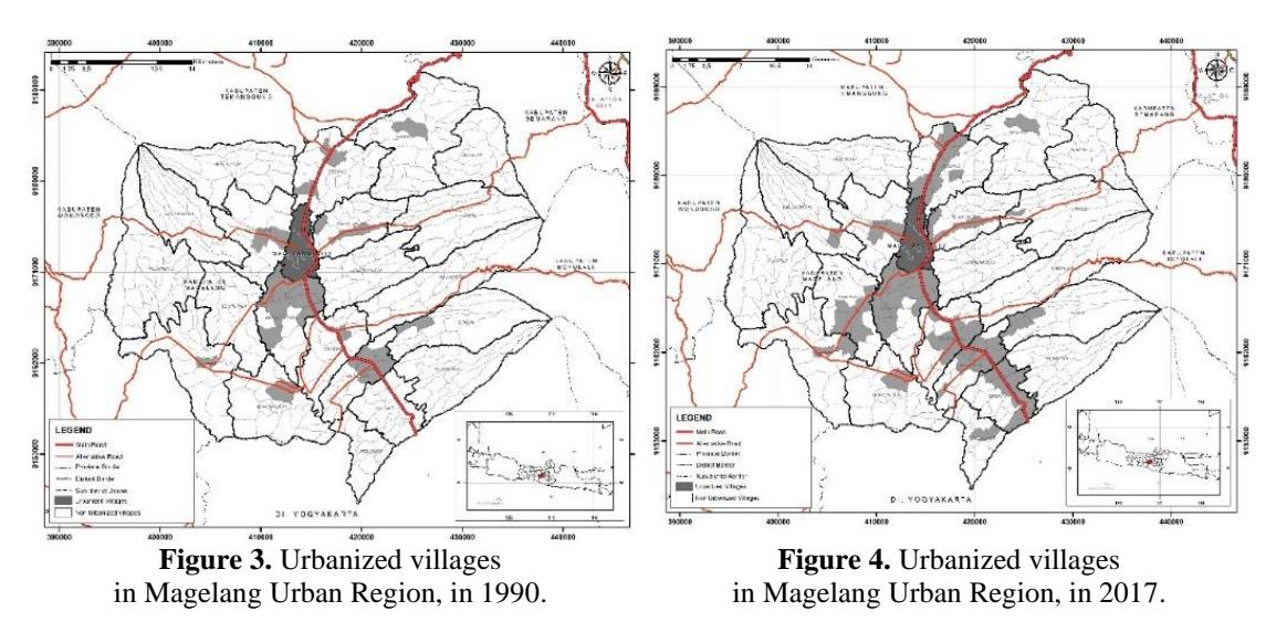
In the case of Magelang Region (see Figure 3 and 4), which lies inland and outside the corridor of the most important regional access route, the situation is very different. Table 3 shows that the peri-urban areas in Magelang Region had the lowest number of urbanized villages. Moreover, the number was much lower than what we found in Kabupaten Pemalang. It is thought that this is because the kabupaten used to have its capital in Kota Magelang, but it was moved to Kecamatan Muntilan in 2000 (although this designation was conducted in 1984).
As shown in Table 3, the number of urbanized villages in 2000 did not change much, except for Pekalongan Urban Region. The number in Tegal Urban Region even decreased in 2000. The numbers increased significantly in 2010. The high increase in 2000 to 2010 is thought to be due to the implementation of a new decentralization arrangement scheme in Indonesia, which provided more authority to the regions in Indonesia, including to the local authorities in kabupaten and kota (non-urban districts and cities). However, since the numbers in 2010 were relatively
similar to those in 2017, the urbanized villages presented in the maps and figures in this paper only depict the situation in 2017 to accompany the maps of 1990.
In 2010, relatively similar to the situation in 2017, urban areas in the two urban regions on the north coast developed much more than during the previous period, as indicated by the growth of urbanized villages. In Tegal Urban Region, the development of urbanized villages spread to other places outside the inverted L-shaped urban corridor area. The large number of additional urbanized villages has changed the shape of the urbanized areas in Tegal Urban Region by spreading urbanized villages outside the previous ones and filling the areas between the previous urban areas. This spatial process has made the urban region become much larger and has made Kota Tegal, because of its location within the constellation of its urban region, give up its role as the center area of the region. If we categorize the small towns formed in this peri-urbanized process into three categories, i.e. larger, intermediate and smaller small towns, it is interesting to note that most of the new urbanized villages in the region fall in the larger and smaller categories, and not in the intermediate category. There were 54 new urbanized villages in towns with a population of more than 50,000 per town, and 35 villages in towns with less than 30,000 inhabitants in this region, while the towns with a population between 30,000 to 50,000 had only 17 new urbanized villages.
The development of urbanized villages in Pekalongan Urban Region showed a similar process of urban village development. The urbanized villages in this region also spread outside the previous ones and also filled in areas between previously urbanized villages, especially in the areas along the Pantura Road corridor in Kabupaten Pekalongan and Batang. However, where the spatial formation of urbanized village development in Kabupaten Tegal moved out of the corridor area to form larger urban agglomerations in the region, the development in Pekalongan Region tended to be concentrated along the corridor, with a lower concentration in the surroundings of Kota Pekalongan. In addition, the development of urbanized villages in Kabupaten Pemalang was similar to that in Pekalongan Urban Region by spreading and filling the in-between areas along the Pantura Road corridor. With the combination of urbanization and peri-urbanization that took place in Tegal Urban Region, the processes in Pekalongan Urbab Region as well as in the transitional areas will tend to create a double-core-metropolitan-region in the future, with Kota Tegal and Kota Pekalongan becoming the western and the eastern cores, with the formation of a 150-km urban strip. The tendencies of the development of this formation are indicated by the development of urbanized villages in the two urban regions as well as in their transitional areas, which showed a similar process, i.e. concentrated development along the Pantura Road corridor.
Meanwhile in Magelang Region, the least urbanized region among the three regions, which had a 34.6% urbanization level compared to 54.8% and 53.5% for the Pekalongan and Tegal Urban Regions respectively, the number of urbanized villages grew more slowly. Although the number was more than double from before, the number of new urbanized villages was much lower (see Table 3). In addition, the spatial growth development in this region was similar to the one in Tegal Urban Region in the early stage of its development, i.e. spatial development along a major regional road (see Figure 4 and Figure 1). It is considered that the low growth in this region is not only influenced by its inland location, but also by the much lower intensity of traffic along the regional road compared to Pantura Road, and also by the smaller size of the city. The distance of the city about 50 km from Yogyakarta in the south and about 80 km to Semarang in the north could not stimulate the emergence of a growth power equivalent to the growth power in Tegal Urban Region or even in Pekalongan Urban Region.
Small Town Development in the Peri-urban Areas of the Small Cities
The identification of towns that have formed and grown in the observed areas was followed by the counting of the population of each agglomeration of urbanized villages formed in the process of urbanization and peri-urbanization in the regions. In this process it is assumed that urbanized villages located adjacent to each other and agglomerated into one cluster of urban concentration within the same kecamatan form a small urban concentration (town). Thus, urbanized villages that are located side by side and agglomerated into one cluster but are located in different kecamatan are considered to form two separate towns. In addition, urbanized villages that are within the same kecamatan but are separated and not agglomerated into the same cluster, are also considered to form two separate towns.
Using this method, we found 64 towns in 1990, which grew into 114 towns in 2010 and 2017, with various population sizes. The largest town by population size in 2017 was Adiwerna in Tegal Region, which had a population of 185,232 inhabitants, while in 1990 it was Pemalang in Kabupaten Pemalang with a population of 93,754 inhabitants. In 1990, the population of Adiwerna was 82,624, while the population of Pemalang was 167,627 in 2017. Meanwile, the smallest town in the observed areas in 2017 was Kandangserang in Pekalongan Region with a population of 1,369 inhabitants and in 1990 it was Blado of Pekalongan Region with a population of 2,146 inhabitants.
Detailed observation of the rapid population growth in the towns revealed that the growth was also influenced by the increasing number of urbanized villages agglomerated in the towns. The largest town in Tegal Urban Region, i.e. Adiwerna, was formed by the agglomeration of 14 urbanized villages in 1990, increasing to 18 urbanized villages in 2017. The largest town in Pekalongan Region, i.e. Batang, had only six urbanized villages agglomerated in 1990, while the number increased to 19 urbanized villages in 2017. An increase of the number of urbanized villages not only occurred in the largest towns but also in other town classes. As an example, Wanasari of Tegal, which had 22,354 inhabitants in its two urbanized villages in 1990, had an increase to 81,897 inhabitants in its nine urbanized villages in 2017. Tirto of Pekalongan Region, which had a population of 9,120 inhabitants from its three urban villages in 1990, had a rapid increase to 63,497 inhabitants in its 13 urbanized villages that agglomerated it in 2017.
Table 4. Development of Towns in the Three Urban Regions, 1990-2017
| Town Size and Region/Area | 1990 | 2000 | 2010 | 2017 |
|---|---|---|---|---|
| Towns with a population of more than 100,000 | 0 | 1 | 6 | 8 |
| - Tegal Urban Region | - | - | 2 | 4 |
| - Pemalang District | - | 1 | 3 | 3 |
| - Pekalongan Urban Region | - | - | 1 | 1 |
| - Magelang Urban Region | - | - | - | - |
| Towns with a population of 50,000-100,000 | 9 | 11 | 15 | 13 |
| - Tegal Urban Region | 6 | 6 | 10 | 7 |
| - Pemalang District | 2 | 2 | 2 | 2 |
| - Pekalongan Urban Region | - | 2 | 2 | 2 |
| - Magelang Urban Region | 1 | 1 | 1 | 2 |
Table 4. Development of Towns in the Three Urban Regions, 1990-2017
| Towns with a population of 30,000-50,000 | 6 | 7 | 18 | 19 |
|---|---|---|---|---|
| - Tegal Urban Region | 2 | 3 | 9 | 11 |
| - Pemalang District | 2 | 1 | 2 | 2 |
| - Pekalongan Urban Region | 1 | 2 | 4 | 4 |
| - Magelang Urban Region | 1 | 1 | 3 | 2 |
| Towns with a population of 10,000-30,000 | 19 | 23 | 33 | 34 |
| - Tegal Urban Region | 9 | 14 | 12 | 12 |
| - Pemalang District | 4 | 2 | 3 | 3 |
| - Pekalongan Urban Region | 6 | 7 | 13 | 13 |
| - Magelang Urban Region | - | - | 5 | 6 |
| Towns with a population smaller than 10,000 | 30 | 29 | 42 | 40 |
| - Tegal Urban Region | 11 | 11 | 18 | 17 |
| - Pemalang District | - | - | 2 | 2 |
| - Pekalongan Urban Region | 13 | 12 | 14 | 14 |
| - Magelang Urban Region | 6 | 6 | 8 | 7 |
| Total | 64 | 71 | 114 | 114 |
| - Tegal Urban Region | 28 | 34 | 51 | 51 |
| - Pemalang District | 8 | 6 | 12 | 12 |
| - Pekalongan Urban Region | 20 | 23 | 34 | 34 |
| - Magelang Urban Region | 8 | 8 | 17 | 17 |
Source: Result of analysis, 2020
The number of towns in each region, classified into five classes of towns based on population size, is presented in Table 3. The table shows that the peri-urbanization process in the observed areas not only tended to increase the number of small towns in peri-urban areas, but also tended to enlarge their size as well. There were no towns with more than 100,000 inhabitants until 1990. The existence of a town of this population size started in 2000 with Pemalang, and increased to six towns in 2010 (Adiwerna and Brebes in Tegal Region; Pemalang, Petarukan and Taman in Kabupaten Pemalang; and Batang in Pekalongan Region) and then to eight towns in 2017 (the previous towns, plus Pangkah and Dukuhturi in Tegal Region). The number of towns in other classes of population size also increased, with the largest increase in towns with a population of 10,000 to 30,000 at 15 additional towns. The increasing number of towns, especially in the larger population size classes, also indicates the increased size of the towns in these peri-urban areas. Pangkah and Dukuhturi had 84,988 and 94,303 inhabitants in 2010 respectively, and today they have become towns with more than 100,000 inhabitants, with 109,361 and 106,440 inhabitants respectively in 2017.
It is interesting to note that the growth of the smaller-sized towns was more dynamic than that of the larger-sized ones. Table 3 shows that the towns with a population of 10,000 to 30,000 had the largest increase, i.e. 15 additional towns in the observation period from 1990 to 2017. In addition, the towns with a population between 30,000 and 50,000 had the second largest increase with 13 additional towns, and towns with less than 10,000 inhabitants had the third largest increase with 10 additional towns. Meanwhile, the towns with a population between 50,000 and 100,000 had the smallest increase, with only four additional towns, but as discussed above, the towns with more than 100,000 inhabitants had a larger increase than the smaller towns, with eight additional towns. This reveals important challenges that require more attention in managing town growth and peri-urbanization in densely populated areas like these regions, i.e. the growth of the largestsized towns and the dynamics caused by the increasing number of smaller-sized towns.
Table 3 shows that Tegal Urban Region was the region with the largest number of towns, as this region had 51 towns compared to Pekalongan Urban Region and Magelang Region, which had 34 and 17 towns respectively (see Table 3). The largest number of towns in Tegal Urban Region was not only in terms of the total number but also in nearly every class based on population size, as Tegal Urban Region had a lower number of towns only in the class of towns with a population between 10,000 and 30,000, while it had a higher number of towns in the other classes. This situation indicates that Tegal Urban Region experienced more dynamic peri-urbanization than the other regions; even though it had a slightly lower urbanization level than Pekalongan Urban Region and also had a smaller sized city as its core than the Pekalongan Urban Region. It is considered that in addition to the location of Tegal Urban Region, along a three-way junction between a regional road and the most important regional road in Java, the more dynamic periurbanization in this region was also influenced by the availability of major towns in the surrounding of the core at a reasonable distance, i.e. about 15 km from the city center to the towns. Tegal Urban Region has two major towns, i.e. Slawi in Kabupaten Tegal and Brebes in Kabupaten Brebes, which act as the capital of their respective kabupaten. In this context, Pekalongan Urban Region is also located along a three-way junction in the Pantura Road corridor. However, the junction of Pekalongan Urban Region is not created by a regional road that is similar to the one that creates the junction in Tegal Region; it is a lower-level regional road that mainly connects areas in Kabupaten Pekalongan. In addition, Pekalongan Region does not have major towns at a reasonable distance like in Tegal Urban Region has. Pekalongan Urban Region only has Batang, the capital of Kabupaten Batang, which is located next to the city at a distance less than 10 km from the city center, while Kajen, the capital of Kabupaten Pekalongan, has not grown since it was first developed in 2001.
Concluding Remarks
This paper revealed that the peri-urbanization process of smaller cities in Java is marked by the occurrence of two intertwined spatial processes in the urbanization process, i.e. in-situ urbanization as well as spatial expansion of urban activities. In-situ urbanization is reflected by the number of villages that emerge as towns (new urban concentrations) in formerly rural settings. Detailed observation of the three cases showed that socioeconomic changes from rural to urbanized villages are mostly affected by one or more intertwined factors. The factors are the administrative, economic, or social functions of the village as well as the availability of road access and transportation facilities and services that connect the village to larger urban concentrations. As Firman (2016) argues, in combination with other surrounding areas and with expansion processes in these areas, the extended urbanization of small cities also leads to the areas gradually changing from rural settings to more urbanized regions. In the long run, these gradual changes can lead these regions to becoming emerging metropolitan areas. The case of Tegal Urban Region shows that these processes have led the region to grow from only having an urban population of 500,000 with an urbanization level of 20.1% in 1980 to an urbanized region that has nearly two million urban dwellers with an urbanization level of 53.5% in 2010. The case of Pekalongan Urban Region showed similar growth, changing the region from having an urban population of only about 350,000 with an urbanization level of 26.0% in 1980 to an urbanized region with about one million urban inhabitants with an urbanization level of 54.8% in 2010. We could also consider that we are expecting the birth of a Tegal-Pekalongan Mega Urban Region in the future with a urban population of more than 5 million residing along this 150-km mega-urban corridor, as we are now witnessing the change of Kabupaten Pemalang, the transitional area that also became more urbanized with a growing urban population from about 200,000 with an urbanization level of 22.0% in 1980 to an urbanized kabupaten, as its urbanization level was 50.5% with about 650,000 urban inhabitants in 2010. Among the three observed regions, only Magelang Region is still predominantly rural until now with an urban population of about 500,000 and an urbanization level of 34.6% in 2010.
This study also showed that the expansion that occurred in the urbanization and peri-urbanization processes of the areas not only came in the form of the expansion of urban activities from the cities to their surrounding areas. The expansion also occurred in much smaller urban concentrations, as many towns in peripheries increased their number of urbanized villages agglomerated in towns. This phenomenon requires more attention in the future, especially if we consider that Java is the most fertile island for rice production in Indonesia, making it the main contributor of rice production in the country, since the growing number of urbanized villages could bring some threats to the availability of paddy fields in the areas. Today, we face a decreasing contribution of Java to the national paddy harvested area from 50.2% in 1993 to 45.5% in 2015 with a decreasing contribution to national rice production from 58.8% in 1993 to 51.7% in 2015, although it rose again to 55.5% in 2019 (BPS, 2020a; BPS, 2020b; BPS 2020c).
In addition, this study also supports Cohen's (2006) conjecture that smaller cities and towns will become one of the key challenges of urbanization related to sustainability, in addition to becoming the largest urban agglomerations in the world. Cohen (2006) states that smaller cities and towns pose significant challenges for several reasons, i.e. their large population counted in a cumulative way, their rapid growth, their underservedness in terms of urban infrastructure and services, and the low capacity of local governments. This study showed part of the features of smaller cities mentioned by Cohen (2006). The growing small cities of Tegal and Pekalongan have created metropolitan areas out of small cities and perhaps even one single mega-urban region. Some of the towns formed in their peripheries are reaching the size of the core, which could also bring significant changes in the relations between the cities and their peri-urban areas in the future. Rapid growth of both larger and smaller towns will eventually change their environment in the long run. Growing small towns in the peri-urban areas also face increased pressures by the increasing needs of urban infrastructures and services, which should be extended to wider urban areas.
A final challenge that is also important to mention are the institutional challenges, especially in the government of kabupaten, that are also posed by this extended urbanization process from at least two points of view. Firstly, as the urban activities in the cities expand to the territory of surrounding kabupaten and form integrative urban regions, there will be a need for integrated planning and management among the localities, kota and kabupaten, that form the urban region. In this context, the government of Kota Tegal and that of Kabupaten Tegal and Kabupaten Brebes, which form Tegal Urban Region, need to collaborate to ensure integrative urban development planning and management so they can have better approaches to improve socioeconomic linkages and spatial integration within the region. Furthermore, as the kabupaten become urbanized regions and have many towns forming and developing within them, there will be a great need for urban development planning and management capacities for each town. This could be a second institutional challenge, as some towns already have a considerable size together with the city that is their urban core for some decades.
Acknowledgement
We thank the Faculty of Engineering, Universitas Diponegoro, for the funding of this research through the Competitive Grants on Strategic Research of RKAT Funds in the Budget Year of 2019 (Contract No. 24961 SPWK15 lUN7.5.3.2fPPl202A). This paper was presented at the 5th planocosmo conference.