
Introduction
This paper draws on two cases of network secession in urban centers to investigate the fragmented landscape of urban Jakarta, challenging a homogenous perspective on urban centers and spatial fragmentation in the city. Scholars have investigated fragmentation mainly in the contrasting conditions of underserviced urban settlements and exclusive premium spaces, as argued in Graham and Marvin's seminal work Splintering Urbanism (2001). The splintering of the urban network occurs through the creation of premium spaces with toll roads, private access, and customized energy and water services, while leaving behind enclaves of 'network ghettos' that are marginalized by the reconfiguration of urban infrastructure. In Jakarta, researchers have associated the fragmentation of service networks with postcolonial planning and control (Kooy & Bakker 2008a, 2008b; Kusno 2016; Putri 2019; Silver 2008), where colonial-era infrastructure facilities such as water and sanitation networks are still limited to former colonial enclaves until today. Network segregation has further exacerbated service inequality in kampungs, where many residents are disconnected from city services.
This study argues that present neoliberal modes of governing also lead to fragmentation in and through high-profile economic districts. The argument developed in this paper follows Coutard (2002, 2005, 2008) in suggesting that premium spaces cannot be generalized to 'premium networked spaces' (Graham and Marvin 2001). According to Coutard, in many cases microlocal disconnection occurs not as a deliberate action but somewhat influenced by poor design, planning and development control. This paper also points out that not all network fragmentation is associated with underserviced/immobile enclaves of the poor or racially segregated communities, as many scholars have suggested. This is in line with Robinson (2006), arguing that modernity needs to be dislocated from its presumable geography of the well-off. Rather than labeling one area as modern or not, this article suggests seeing city-making as an ordinary process.
The road network is especially interesting to explore as it represents the (dis)modernity of an urban area. Still, it is also experienced and constituted in the everyday life of urban residents (Harvey, 2010). With the high-profile public image of 'business improvement districts' and other sorts of premium enclaves in splintering urbanism, it is argued that there needs to be a detailed mapping and exploration of how the road network constitutes this common space. Bringing road fragmentation and its relationality with the production of secessionary space into the discussion agrees with Cresswell's (2010) call for a 'new mobilities' paradigm, where discourse, practice and materiality account for the (re)production of distinct mobile and sedentary life and space.
In substantiating the argument, this article analyzes two urban centers in Jakarta: TB Simatupang in South Jakarta and Puri Indah Central Business District (CBD) in West Jakarta. These centers were chosen to illustrate how these centers are disconnected from the larger urban structure but still continue to grow as activity magnets. TB Simatupang represents a fastgrowing but unplanned business area where splintering and disconnection are embedded in private plot acquisition, particularly between primary and secondary corridors. Unlike TB Simatupang, which has been growing rapidly without proper planning efforts, Puri Indah CBD was planned as the primary center of West Jakarta in 1986. Nevertheless, it remains disconnected from a vast public transportation network.
This paper explains both cases through the lens of local transportation and road networks, which constitute the city's mobility structure. TB Simatupang and Puri CBD illustrate how even
formal planning procedures fail to consider the transformation of urban centers. In Jakarta's spatial planning documents, urban centers are defined based on their functions: administrative, office, trade, service, industrial, social, cultural, transportation and multifunctional centers. The development of urban centers in Jakarta dates to the quest for national pride in Soekarno's regime (1945-1967) and aimed to develop extensive commercial expansion along Thamrin– Sudirman. This was followed by the development of the Golden Triangle according to the 1985- 2005 plan for Jakarta under Soeharto's regime (Silver 2008). In the 1990s, the idea of distributing activity centers to West and East Jakarta was developed. Puri Indah CBD was planned as the new primary center for West Jakarta (Saputra and Herlambang 2019). The development of this area has not been significant until today. On the other hand, the TB Simatupang corridor has grown rapidly despite being unplanned. Recent significant transportation infrastructure improvements such as MRT and LRT also failed to follow the initial development plan of the primary west and east centers, instead cutting through TB Simatupang and triggering large-scale project development in the corridor.
Figure 1. TB Simatupang, a growing business corridor in South Jakarta.
Figure 2. Puri CBD in West Jakarta, served by the ring road infrastructure.
This paper starts with a brief history of Jakarta's urban centers and a critique of the splintering urbanism theory. In positioning this article within the broader theoretical discussion, the 'premium network spaces' thesis and its interplay with neoliberal urban policy will be discussed (Graham 2000; Graham and Marvin 2001). Next, this article describes the profiles and network fragmentation of TB Simatupang and Puri Indah CBD in greater detail, based on archival research, particularly planning and design guidelines for Jakarta and mapping from 2017-2019, illustrating how network fragmentation was produced in these two urban centers of the city. Next, a comparative analysis of the two case studies is presented. Summarizing the result, this paper proposes to see fragmentation of urban networks as an ordinary process. Fragmentation results from neoliberal planning policy and lacking planning control. Rather than exclusive, fragmentation is omnipresent throughout the city, even in the so-called central business districts. It is within these fragments of networks that ordinary economic productivity is present. Finally, a twofold reflection on the two cases is presented: theoretical for studies in urbanism and practical for urban planning practice in Jakarta.
Situating Premium Network Space
In portraying the fragmentation of space in today's urbanization, Graham and Marvin deciphered what they call 'premium network space', which is an enclave "… splintering off from the wider urban landscape while connecting intimately with international circuits of economic, social, and cultural exchange" (ibid., p. 249). They developed their thesis by exemplifying many forms of enclaves, such as privatized urban highways, splintered internet for corporate purposes, private-public spaces, business improvement districts (BIDs), theme parks, malls, and gated communities. These new urban spaces have become means to achieve neoliberal goals of enticing private investment in order to ensure competitiveness. Urban secessionary space has been primarily associated with class and racial issues. Graham and Marvin used the terms 'figured' and 'disfigured' spaces in a binary view of networked and disnetworked spaces. The latter have suffered from inadequate network infrastructure instead of premium enclaves, thus leading to socio-spatial marginalization, as other scholars have also argued (Anand 2017; Kooy and Bakker 2008b, 2008a).
Scholars have investigated how road construction and engineering reflect the state's effort to construct modernity. Like other kinds of infrastructure, roads bring together the state, local community and experts into relations mediated by their existence and materiality (Harvey 2010). They reflect the state's ambition towards modernity, "… not just through the transformations that they promise, but also by arranging and rearranging the mundane spaces of everyday life" (Harvey and Knox, 2015, p. 7). Kusno (2016) argues for the portrayal of the modern street network as a parallel of colonial governments rendering ungovernable enclaves – in this case kampungs – streetless. Much attention has been paid to the construction of elevated roads as conduits of speed and uninterrupted flow, facilitating the enclavement of elites (Graham, 2018). Harris (2018) too explains how the notion of 'formality' – bringing order and linearity to chaotic mobility – is produced and embodied in material and engineering practices such as flyover and skywalk construction, against the 'informal' and unruly urban practice.
Splintering networks do not necessarily create seccessionary spaces. Critiques on premium networked space have shown how this thesis has failed to explain the relationship between the network's differentiation and its support function (Coutard, 2002, 2005, 2008). Moreover, studies in the ethnography of infrastructure have elucidated how modern infrastructure ideals implemented by neoliberal governance have instead produced a fragmented and non-linear infrastructure development practice (see Harvey and Knox, 2015; Anand, 2017). Aware of the risk of a binary 'figured' and 'disfigured' network landscape, Graham and Marvin argue that the practice of configuring infrastructure into privatized enclaves and the city is 'uneven and porous' (ibid., p. 389). Acknowledging the differentiated landscape they constitute, such enclaves cannot be rendered into a unitary whole but instead are situated in contested spaces and contexts (ibid., p. 389). Their connection to the rest of the city remains critical to sustaining their existence in spite of the splintering network.
Graham (2000, p. 191) also highlights the diminishing role of comprehensive urban planning in a segregated urban landscape, which tends to celebrate urban projects or "archipelagos of enclaves" (Bosma & Hellinga, 1998, p. 16) rather than promoting an integral approach. Urban planning policy has long been argued to be useful in creating governable subjects in order to achieve neoliberal goals of inter-city competition and public entrepreneurialism (Sager, 2011). This aligns with the premium network spaces realized through planning discourse, documents and techniques, including zoning and density regulations. Given this background, the current study focused on the intersection between network fragmentation, premium urban enclaves, and urban planning. The case studies discussed in the following part are presented in order to exemplify the differentiated context of (dis)connection within and between premium enclaves and the city under neoliberal urban policy.
The Tales of Two Urban Centers
The Disconnected Center: Puri Indah CBD
Unlike the TB Simatupang corridor, which remains unclearly delineated despite its fast transformation, Puri Indah CBD was purported to become the new center of West Jakarta by the city government in 1986. The project covers 135 hectares and was acquired by two large developers: PT Antilope Madju Puri Indah and PT Lippo Karawaci Tbk. Puri Indah CBD now offers a wide range of activities: offices, shopping centers, superblocks and public facilities as well as high- and low-rise housing. The development started in 1997 with commercial functions, including Puri Indah Mall and trade centers. The relocation of the West Jakarta Mayor Office followed around 2000 along with other facilities and commercial and residential developments. A Lippo representative once contended that "infrastructure in Puri CBD is relatively better and well laid out because it is designed with a city block concept to be more comfortable for drivers and residents to walk in, like New York." The statement clearly shows how the idea of modern infrastructure in the form of grid blocks, streets and pedestrian roads has influenced Puri Indah CBD's development.
Nonetheless, in comparison to its early design guidelines in 2006, the existing development is still far from being fully realized, as many plots are still vacant (Saputra & Herlambang 2019). Despite being designated in the planning document, Puri CBD is outside of the public transportation network. Figure 1 illustrates the transportation networks, where only one angkot (minibus-feeder transportation) operates within a short range of mobility. Despite being devised as the new center of West Jakarta it has failed to achieve the popularity of Grogol, West Jakarta's center before the development of Puri Indah CBD, mainly because it is served by limited options of public transportation (Saputra & Herlambang 2019). This premium space is car-dependent and only accessible from the Jakarta Outer Ring Road (JORR) and serves only middle-upper class communities. This proves that whenever planning fails to integrate business districts into the more extensive urban transportation network, the same planning scheme also fuels enclave segregation.
However, planning mediating network fragmentation can occur at the urban level as well as within a premium enclave. Figure 2 shows St. Moritz, a mixed-used development in Puri Indah CBD that utilizes vast land acquisition, fragmenting the road network and thus making the inner-spatial structure of the business district less accessible. Discretion of the zoning plan exacerbates the fragmentation – particularly with high-density and intensive activities within the area, a fragmented inner spatial structure causes inefficiency of mobility.
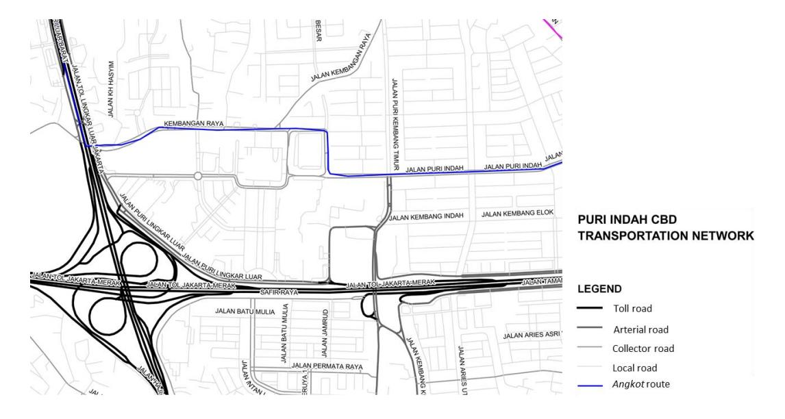
Figure 3. The Puri Indah CBD transportation network: partial public transportation network and disconnection from the rest of urban Jakarta has resulted in an enclave that is highly dependent on the automobile.
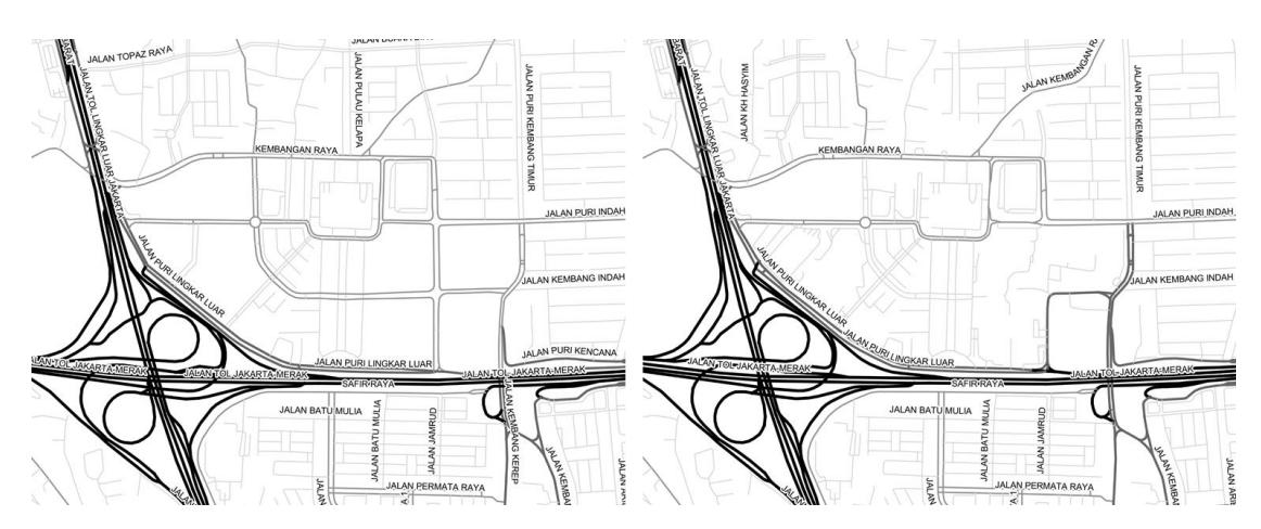
Figure 2. Fragmented road network in a premium enclave: the image on the left illustrates the road network as planned in Jakarta's Detailed Spatial Plan (RDTR) of 2014. The image on the right shows the fragmentation of the network due to extensive land acquisition as opposed to the grid in the planning document. (Source: Saputra & Herlambang, 2019; redrawn)
The Unplanned Center: TB Simatupang Corridor
The development trend of the TB Simatupang corridor can be traced back to as early as 1985, where most of the area was delineated for residential and low-density commercial development. Initially, the South Jakarta region with its higher elevation was planned as a water catchment area in order to avoid excessive runoff to the city. However, today's corridor has been transformed into a mix of commercial, service and high-density residential functions. Even in Jakarta's Detailed Spatial Plan (RDTR) from 2014, the southern part of the TB Simatupang corridor is no longer delineated as a green space and low-density residential area. The increasing connectivity has extended the transformation toward the Jakarta Outer Ring Road, which integrates the corridor with strategic functions in Jakarta, including airport, harbor and industrial estates. Significant infrastructure development in this corridor (toll toad and MRT line) has triggered investment in large-scale real estate projects, including superblocks and office parks (see Figure 3). The planning documents also authorize the increase of building intensity, particularly in major property development. Fatmawati City, for example, was the first Transit Oriented Development area in Jakarta, with the allowable floor-area-ratio (FAR) increasing from 0.4 to 4.5 and the building-coverage-ratio (BCR) increasing from 5-20% to 5- 55% in 2005 and the Detailed Spatial Plan from 2014.
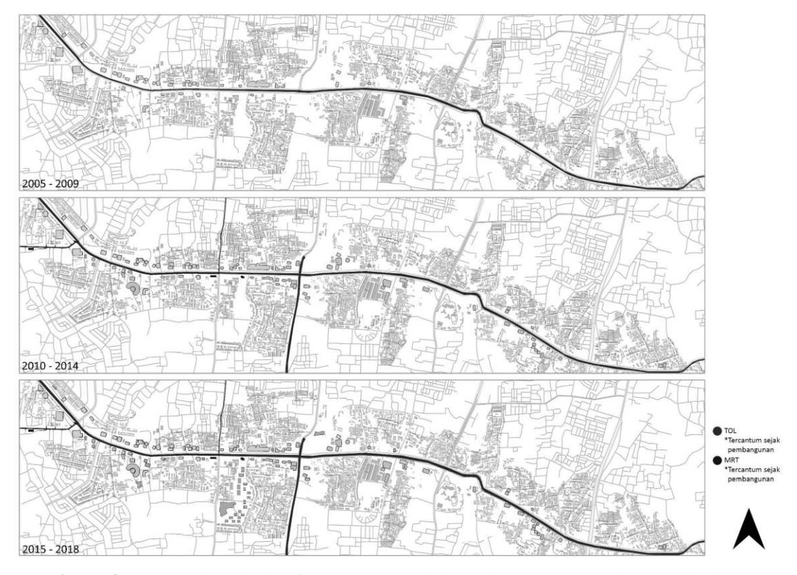
Figure 3. Temporal analysis of macro-connectivity and property development in the TB Simatupang corridor with the construction of the Depok–Antasari Toll Road. (Source: authors)
Meanwhile, the construction of major toll roads connected to the corridor, i.e. the Pasar Rebo– Veteran toll road in 1995, the Serpong toll road in 2004, the Ulujami–Kembangan toll road in 2014, and the Depok–Antasari toll road in 2018, have significantly affected the internal mobility structure of the TB Simatupang corridor. However, referring to the Jakarta spatial plan from 2005, there has been a minor alteration of the inner-spatial design of the TB Simatupang corridor. Primary road connections, as mentioned above, have triggered remarkable development of the front-road layer. However, this development was not followed by an improvement of secondary-arterial roads and secondary blocks behind the front layer. Figure 4 below illustrates the disconnection of the road network, particularly in the second block, as the corridor development was driven by private and disintegrated plot acquisition. The recent construction of MRT lines passing through the corridor has increased spatial fragmentation, as transit nodes are not well integrated. Despite the increasing number of functions and density in the TB Simatupang corridor, the spatial structure remains disintegrated and degraded.
Figure 4. The fragmented road network of an emerging business corridor. (Source: authors)
Despite its striking transformation and privilege in macro-connectivity, this corridor remains underexposed. The current planning document fails to consider it, disregarding its potentiality as an urban center. The spatial planning document proposes only one properly planned center in the spatial structure plan and overlooks emerging business centers like TB Simatupang. The planning document here enacts the neoliberal technology of rendering investment possible, both through incentivizing and disincentivizing development. With the alteration of land-use allocation and density index in the TB Simatupang corridor and the looseness of development control, along with its disregard as an urban center in the spatial structure plan, significant land acquisition for property development is made possible regardless of its disconnection from surrounding plots.
Following Kooy and Bakker (2008a, 2008b) it is argued that the case of network secession in Jakarta is not splintering but splintered, as facilitated by the neoliberal urban policy. Figure 5 illustrates the accreting splintered network through parcel acquisition by large-scale developers from the case of Fatmawati City Center. The spatial structure is adjusted to fit the purpose of the development rather than supporting the larger spatial arrangement of the TB Simatupang corridor. This case study shows how planning documents mediate the splintering of premium enclaves by legalizing road network re-assembly to support private development rather than connecting the corridor's components as a single integrated business center.
Figure 5a-c. Planning adjustment of the road network in a premium urban enclave.
Figure 5a illustrates the planning guidelines from 2005, in which the road network was planned to cut across the parcel, connecting it to the next lot. Figure 5b exemplifies the change in the Detailed Spatial Plan from 2014, where the connecting road network does not exist. Figure 5c illustrates the project's master plan in which the spatial structure is re-invented to support the commerciality of the project.
Spontaneous Centers: The Ordinary Fragmented Network
In developing the argument for the TB Simatupang corridor, it is argued that the planning document renders its expansion organic and spontaneous. At the same time, it also facilitates the corridor's development through discretionary zoning regulation and increasing regional connectivity with MRT and toll road development. This paper criticizes Puri Indah CBD's loss of connectivity to the broader urban region, primarily facilitating middle-upper class communities, who are highly dependent on the automobile. Both cases also show fragmentation of the road and transportation networks within enclaves with the expansion of two significant superblocks, Fatmawati City Center along the TB Simatupang corridor and St. Moritz in Puri Indah CBD. This finding aligns with Kooy and Bakker's (2008a, 2008b) statement that infrastructural networks, in this case the road network, is not splintering but splintered by private development. A comparison between both cases is made in Table 1 below.
Using the cases of two urban centers in Jakarta, the TB Simatupang corridor and Puri Indah CBD, this paper proposes the need for further exploration of premium network spaces as theorized by Graham and Marvin in Splintering Urbanism. Our findings point out that such secessionary spaces are rather particular in different urban settings. This article challenges the general portrayal of premium network spaces as highly connected enclaves to facilitate financial circulation on the global-local scale (see Graham, 2000). Both cases illustrate fragmentation in urban Jakarta, manifesting itself in underserviced low-income settlements and high-profile business centers, within and through the premium networked space itself, whose processes are allowed by the current neoliberal regime of urban planning. It is also argued that highly differentiated and erratic network infrastructure in premium networked spaces often does not follow any standard. Therefore, rather than contrasting the socio-economic landscape of a city based on its (dis)connection, we argue that network fragmentation needs to be dislocated from geographically underserviced areas and instead seen as an ordinary and mundane practice (see Robinson, 2006). Dislocating the idea of modernity from the premium enclave, this study provides a new perspective for the exploration of the diversity of urban Jakarta.
Table 1. Comparison between TB Simatupang corridor and Puri Indah CBD
| TB Simatupang Corridor | Puri Indah CBD | |
|---|---|---|
| Year of development | 2010s (unplanned development) | 1986 |
| Spatial form | Corridor development | District development |
| Functions | High-rise residential, office, | High- and low-rise residential, office, |
| commercial, and service use; | commercial, and service use; | |
| government administration and | government administration and | |
| public facilities. | public facilities. | |
| Accessibility | Jakarta Outer Ring Road (JORR), | Jakarta Outer Ring Road (JORR). |
| Pasar Rebo–Veteran, Serpong, | Public transportation: One local | |
| Ulujami, Kembangan and Depok– | feeder (angkot). | |
| Antasari toll road | ||
| Public transportation: | ||
| North-south MRT line, 4 | ||
| TransJakarta lines connecting to | ||
| Central Jakarta | ||
| Urban spatial | Not delineated as an urban center in | Designated as the primary center of |
| structure | the spatial structure plan | West Jakarta |
| Inner spatial structure | Stripped development; fragmanted | Planned-district development; |
| network between plots. | fragmented network between plots. |
Following Graham (2000), this paper illustrates that urban planning has rendered itself into a neoliberal technology, capable of prompting privatization and capital accumulation, thus producing differentiated secessionary urban spaces while causing those spaces to be disconnected from the broader planning context. This article also illustrates two cases of how large-scale private development can maneuver around the regulatory planning regime to facilitate its growth, which again manifests itself in the fragmentation of networks within premium enclaves. It is in such fragmented, differentiated, unstable – yet ordinary – networks that power is being exercised, in this case, through planning and negotiation between the city government and private developers.
Conclusions
This paper sought to explore a differentiated narrative of premium networked spaces through careful mapping of road and transportation networks in two of Jakarta's urban centers: the TB Simatupang corridor and Puri Indah CBD. It looked at the interface of neoliberal urban policy, with planning as its technology, and network infrastructure to illustrate erratic and nonlinear transportation networks in premium networked spaces. The findings also suggest that the road and transportation infrastructure in Jakarta's urban centers is not splintering but splintered by private development and that planning mediates fragmentation and capital accumulation in the city. The splintering results in disconnection in and through planned and unplanned urban primary centers. This article offers the concept of ordinariness as a lens through which urban networks in Jakarta can be investigated. Here, fragmentation is seen as mundane, distributed and not exclusive to underserviced urban settlements. As more exploration of the banality of network fragmentation in the Jakarta urban network is needed, further studies in this field are suggested to situate such splintering in a historical context and the infrastructure's situatedness and agency in (re)arranging the everyday life of residents of Jakarta.