
Introduction
Communality is prime in kampungs and fundamental in developing collective kampung architectural space. Communality grows according to the inhabitants' culture and is accommodated by the kampung's infrastructure as an intermediate space. Unlike formal development, which often reflects individuality, communality is based on sharing common issues, interests, and activities based on togetherness to achieve the same objective (Maliki, Abdullah, & Baharuddin, 2015). This includes developing space and environment based on mutual benefit, collaborative intelligence, common sense, and collective wisdom. Culture has always been one of the most fundamental aspects of kampung territorial analysis, as new structures are continuously created based on a common collective perception initiated by communal activities that occur within the kampung's corridor network structure.
One of the most well-known historical and culturally important kampungs in Indonesia is Kampung Taman, situated in the center of the capital of the Special Region of Yogyakarta. This kampung is growing and developing at the previous location of Taman Sari, which was formerly Ngayogyakarta Hadiningrat Palace's garden, a combination of green and blue areas, estimated as large as 10 hectares. It once consisted of 57 buildings, a combination of pavilions, ponds, bridges, canals, lakes, and even artificial islands. It was effectively in use from 1765 to 1812; however, at present, only the southwestern part of the complex is left, which is in ruins. The overall structure of the complex is generally considered damaged; part of it has been conserved architecturally, while the rest is occupied by informal settlements, known widely as Kampung Taman. The residents of Kampung Taman are later generations of the original inhabitants as well as people who previously lived nearby the complex. These later generations moved in, grew, and filled the cavities in the Taman Sari complex (Figure 1), transforming a temporary settlement into permanent housing among existing spaces (Schilders, 2010).
This research investigated Kampung Taman's social space transformation, focusing on territorial perception-based on-site activities. Inhabitants' and visitors' interpretations play a major role in transforming the private domain and leftover spaces into communal and public spheres (Maliki, Abdullah, & Baharuddin, 2015). Communal activities are considered spatial negotiations between residents through bargaining and bartering against personal boundaries, unexpectedly developing symbiosis between inhabitants, as reflected in the kampung's physical structure. Focusing on communal activities, the kampung corridor network was the key area for the present research. Territorial negotiations are illustrated as spatial patterns, drawn in diagrams, reflecting the natural transformation of Kampung Taman. These patterns suggest an organic process of urban development depending on communal activities.
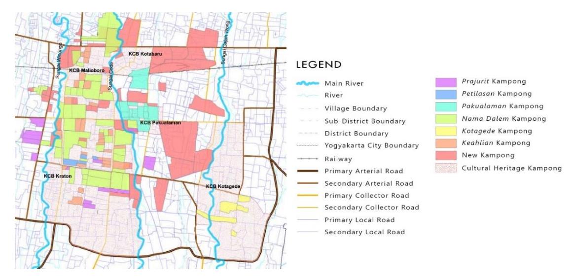
Figure 1. Kampung Taman's Zoning and Development. Source: Center for Heritage Conservation, the University of Gadjah Mada, 2018.
Materials and Methods
This research utilized the snapshot method for developing architectural mapping diagrams based on territorial analysis. A survey was conducted on-site, emphasizing visitation, on-site sketching, and photography. Samples were taken during working hours (09.00 to 17.00). At the same time, observation was done within the boundaries of Kadipaten Lor, K.H. Wahid Hasyim, M.T. Haryono, and Brigjen Katamso Boulevards as the outer parameter and various kampung zones defining the corridor network. The snapshot method was implemented based on photographic documentation to reflect the common perception of inhabitant representatives and categorize the corridor network according to infrastructure type; thus, an infrastructure hierarchy could be defined. Locations and schedules of inhabitant representatives were consulted. The Center for Heritage Conservation acted as a local consultant, also helpfully advising, supporting secondary data collection, and assisting in the actual investigation.
This research was conducted by capturing samples on-site (Flanagan, Georghiou, & Halfpenny, 2000) from Augustus 2018 to November 2020. The samples were taken by emphasizing the importance of physical representation rather than events or moments in Kampung Taman's corridors. The kampung corridor network is perceived as the nexus, the backbone of the case research, as an essential piece of infrastructure consisting of spaces between zones left open by the kampung. It was chosen as the research object to complement previous research, which focused on Kampung Taman's physical structure rather than territorial activities. Architectural diagrams were used as a tool for visualizing the patterns of Kampung Taman's territorial activities. The map was re-traced, re-drawn, re-colored, and recalculated using Autodesk 2018. The photo-collage technique was later used to highlight the territorial analysis using Photoshop. It should be read as a compilation of images rather than as individual images, arranged to show a pattern resulting from a continuous process and action, emphasizing the Kampung Taman's boundaries, territory, physical space, form, and structure.
Derived from a Proto-Indo-European word, ters means dry. Terra is a derived word that refers to land. It has precisely the opposite meaning of water: land is perceived as an area that can be conquered or occupied. It can also be related to one's ability to discover new areas (terra incognita). The suffix -orium was later added to terra to emphasize 'place' as a meaning.
Territorium refers to an area delineated by borders on a map to indicate the measurement of a land, which is often equal to the extent of a state's political power. Later, the word territorium obtained a more negative association linked to domination or superiority.
Human beings want to claim and defend their territory so as not to be disturbed by others (Newman, 1972 b; Holahan, 1982; Haryadi & Setiawan, 2010, p. 38; Lyman & Scott, 1967; Sommer & Becker, 1969; Aurora, 2014, p. 12). Humans are willing to interact with others to obtain a more expansive territory and maintain it together in everyday life (Altman, 1975; Sommer, 1969). Building dwellings is a process of creating linkages between humans and their place, environment, and neighboring lives (Heidegger, 1971, p. 147; Schulz, 1988, pp. 17-38; Salura, 2001, p. 55). Territoriality is formed by residents' needs, behaviors, characteristics, and socio-cultural conditions (Lianto & Dwisusanto, 2015, p. 226). Togetherness and social interaction/psychological needs characterize living without reference to territorial boundaries (Lianto, Arifin, & Dwisusanto, 2017, p. 404).
In architectural jargon, the word 'territorial' is also used in relation to the expertise of securing asylum or governing a region. It means an animal instinct to defend against conspecifics within a defined sociographical area in ethology. At the same time, the Latin term terrere is defined as a fear raised when entering a prohibited area. Compared to its original meaning, the word 'territory' has adopted negative connotations in various fields. A misunderstanding may affect the development of territorial theory when interpreting a region or land as part of a country (Partridge, 2006, pp. 3419-3420); a physical boundary, for example, is always present in the mind when perceiving a territory. Instantly, the territory is understood as a spatial construct that reflects the power of the state rather than elaborating on the meaning of the space or understanding it as part of the relationship between humans and their environment (Delaney, 2005, p. 15). In contrast, this research would like to offer a different perspective: 1) to oppose its generic meaning as a space or place that is used for a specific function and is controlled/owned or regulated by a dominant power; 2) to oppose its symbolic/figurative meaning as a place that provides a sense of security to those who are afraid of danger or unwanted interactions; 3) to extend its meaning related to defense mechanisms and its symbolic attachment to a person, a community, or a society (Edney, 1976). Instead, this research aims to give added meaning to 'territory' as 1) a negotiated space; 2) part of architectural language as a medium of communication and relationships between humans; and 3) to stimulate questioning of superficial ownership of land property commonly labeled as territory (Lyman & Scott, 1967; Skaburkis, 1974).
The physical structure has always been interpreted as the hard element of the city; it constructs the space architecturally. Even if space is not consistently recognized as physical, it is usually associated with physical boundaries in architecture, generally delineated by gates, fences, railings, walls, or any other barrier that indicates a territory. Although the physical structure is often associated with territory, it usually refers to a structural composition as a dominant physical element that supports a building or a field. It is a structural arrangement composed according to a construction logic, aimed to bear the burden of a building or a field, and taken as a series connecting and integrating different parts. This definition is etymologically taken from the literal meaning of the word 'structure' from the late 16th century. It refers to connecting elements by systematically arranging a composition, using construction logic to form a building. The word 'structure' has always been associated with building construction or urban fabric formation as the city's fundamental components. Structuralism later emerged as an -ism, a method of interpretation focusing on relationships that interpret human aspects through thinking, culture, and experience, emphasizing the contrasting relationships between the elements that form a conceptual system.
Architecture is unavoidably associated with relationships as a product of culture; the composition of buildings can be read as a language, with a further interpretation of its structural elements, forms of symbols, signs, and gestures. This includes a pattern that shows diversity extracted from a building as a cultural product constructed based on the human experience. Architecture's surface and deep structures may be investigated to reveal a pattern of relationships reflected in its physical structure. However, rather than focusing on understanding structure as a barrier, this research explores the corridor network as the backbone of Kampung Taman, an infrastructure that connects people. The structure is observed to understand their interrelationships by focusing on spatial interventions based on Kampung Taman's communal circulation activities. In this sense, the corridors are taken as a network that unifies, distributes, and gathers the people who live in the kampung's cells (Maliki, Abdullah, & Baharuddin, 2015). We argue that this network is the kampung manifestation of a system that preserves togetherness, sharing, and social interaction as reflected in reciprocity.
Urban kampungs are the Indonesian city's informal settlements. As the city's antithesis, they can be understood as a compilation of informal structures in an urban area, with its population often marginalized, as they live illegally and do not meet the normal standard of living requirement (Maharika, 2016). Yet, the existence of urban kampungs is supportive of the city environment. Its inhabitants are creative in fulfilling the city's requirements, producing various materials in contrast to the city's industrial products. Urban kampungs generally consist of non-permanent structures made from any available materials. The architecture is constructed using the inhabitants' craftsmanship and construction knowledge inherited from their place of origin. The urban kampung has an organic character; it does not only mean a compilation of houses made of natural materials but it is also developed based on a system of kinship, cooperation, negotiation, and natural principles (Rolalisasi, A., Santosa. H., & Soemarno, I., 2013). The physical structure of the kampung has distinctive spatial perceptions that are different from other informal settlements and general western architecture theory, a new formula constructed by kinship, cooperation, and consensus agreement (Schilders, 2010).
In contrast to the conventional perspective, this investigation suggests a new understanding of territoriality based on the informal physical structure exhibited by non-permanent materials used in Kampung Taman. Territoriality in this sense is formed based on the activities and perceptions of urban kampung inhabitants, considering their needs, behaviors, characteristics, and sociocultural conditions. Territorial activities are not individually constructed but represent a commonality that has been compromised through the territory. A well-established relationship between the occupants blurs the boundaries of private territory and changes it into an informal 'joint ownership' (semi-public territory), constructing a new possibility of spatial understanding that may differ from informal settlements in other parts of the world.
Results and Discussions
Theoretically, the territory does not only exist in a military or administrative context. Its actual definition is close to our daily life activities, and we often have to look at its implementation to be able to define the actual space. Although related, the territory is not only defined by boundaries. For instance, Kampung Taman's case defines social relationships reflected in the development of communal space. In Kampung Taman, the territory is flexible, adaptable, and negotiable, opening up various opportunities to develop and produce a new spatial engagement. This is used here in contrast to the simple definitions of territory. This research investigated another possibility of investigating the actual implementation of territory, initiated by on-site negotiation while questioning the meaning of boundaries that are undeniably unfixed but still fully accepted and recognized by Kampung Taman residents. Rather than presented conventionally as twodimensional dashed lines on a map, three-dimensional formations are offered to analyze the territory of Kampung Taman; both macro and micro implementations of territory are illustrated to describe a spatial arrangement, challenging the fixed definition of what a territory is. In so doing, the physical structure of Kampung Taman is presented as a compilation of urban rooms with a territorial engagement that does not remain steady. Instead, it is always dynamic, fluid, and organic, supported by family systems. This may be why the abandoned site of Taman Sari could be naturally transformed into a dense settlement, shifting from ruins to tourist attractions, maintaining and empowering the area by elevating the power of reciprocity (Figure 2).
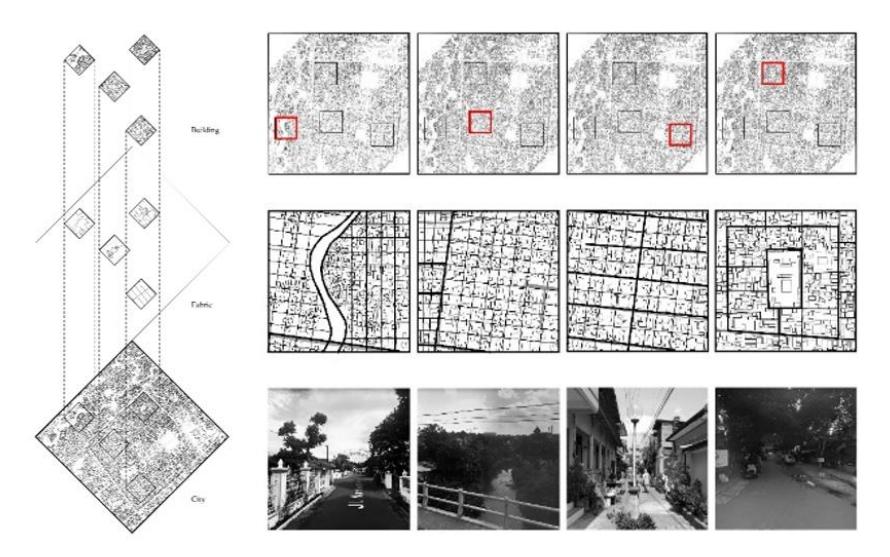
Figure 2. Exploded axonometric physical structure of Kampung Taman, showing territorial activities reflected mainly in the networks. Source: Authors, 2018.
Like other urban kampungs, Kampung Taman grows according to residents' initiative, who previously lived in dense settlements surrounding the artifacts. Residents have gradually taken over Taman Sari's ruins to accommodate new functions. They started by making an enveloping gesture around the artifact, continuously further injecting a corridor to start penetrating into the actual voids at the center of the ruins. Unlike real estate with a formal character, Kampung Taman was initiated by controlling the periphery rather than taking control of the center. It tends to be a continuous rather than a dividing gesture. Although informal settlements may generally grow on separate islands, there is a tendency to interconnect and link by stitching gaps. An urban stitch can be constructed from permanent and non-permanent materials, used for physical and nonphysical structures, and accommodates communal activities. These take over the corridor, connecting informal parcels like urban patchwork (Figure 3).
Kampung Taman grows by elevating reciprocity and consensus; the development of the kampung starts in communal space rather than being initiated by a family. Communal and public spaces are places of compromise; often, general agreements reflect shared interests, sports, and facilities where information and goods are distributed by using the corridor network. However, unlike ordinary corridors claimed by western architecture, the corridors of Kampung Taman flow and transport its residents and accommodate standard programs and events held for the sake of togetherness. In this sense, Kampung Taman's corridors not only act as a circulation network per se but rather as a place for gathering, expressing, learning, playing, and even praying. Such expressions are communication media for the residents of Kampung Taman, emphasized body language, gestures, activities, and programs, exhibited in drawing, coloring, ornaments, mats, space rental, planting, selling, maintaining, securing the kampung, and other activities that show togetherness.
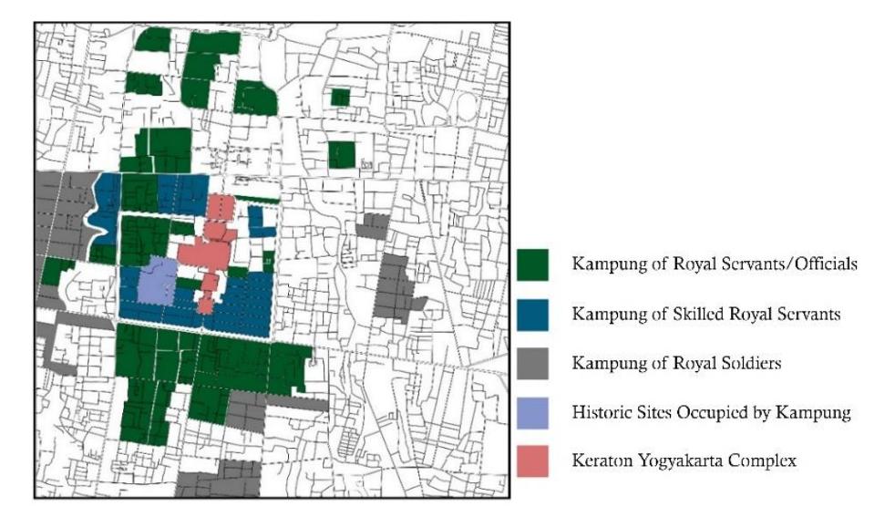
Figure 3. From Territorial Activities to Urban Patch: Building an Interconnecting Kampung Types Organically. Source: Authors, 2018
a. Snapshot Method for Territorial Analysis
The snapshot method was applied to the corridors as the main space for communality to understand the territorial activities in Kampung Taman. Several spatial gestures are highlighted as a pattern to demonstrate the nature of negotiations, family principles, cooperation, and consensus. Through investigation, these steps are listed to show the types of development:
- 1. Joint activities as a collection of communal actions. These take place in a particular location within a limited time frame that are naturally agreed upon, such as playing together, reaching consensus, celebrating events. At this level, activities may create a boundary or a territory by making gestures and movement, especially along the kampung corridor with no or little structure being added.
- 2. The communal expression is kampung dialogue, a compilation of various creative activities by individuals initiated by kampung residents, permitted and supported by the heads/chairman/seniors to achieve an agenda. For instance, applying new colors for the Rainbow Kampung program, constructing ornaments for celebrating Indonesian Independence Day, initiating a medicinal garden for Green Kampung, and decorating the kampung for celebratory events. These expressions add to or change the existing structure without physically transforming it dramatically. However, these changes may stimulate a different perception of property boundaries or even kampung territory.
- 3. Sharing space for common/public interest is a spatial compromise, an organization or a system, agreed-upon negotiation between fellow residents or all inhabitants to utilize a leftover spot, a shared space, a public sphere for public facilities or amenities, for example, parking spaces, sitting rooms, and a security gate. A new system can be injected into the kampung structure as a structural element. A targeted space can be changed to signify a new function. A new boundary may be established especially surrounding the added structure, while the territory of the kampung is significantly changed.
- 4. Structure transformation is reflected in the overall structure of the kampung. This is often initiated by a kampung activity, agreed upon by consensus of all residents, with the particular
purpose of constructing a mutual symbiosis between residents and probably external parties. Governmental offices or non-profit organizations are typically involved in leading dramatic transformations. Typical activities are repairing, cleaning, and maintaining the kampung. The transformation involves constructing new physical points, facilities, and urban structures of a particular or the whole area of the kampung. Structure transformation prepares the kampung for a more extensive agenda, for example, the Kampung Improvement Program, Vertical Kampung, Digital Kampung, and Kampung Tourism. Such plans change the physical structure of the kampung continuously. It results in a reconstruction of different boundaries or territories that is hard to predict, depending on how successful the program is. Although new agendas always claim to significantly extend the kampung, there has always been a possibility of changing or even destroying the genuine principles of the kampung when it is not maintained correctly.
Figure 4. Kampung Taman Zones produced before 2018. Source: Center for Heritage Conservation, the University of Gadjah Mada, 2018.
The categories above are meant to explain the initial kampung development layers. These should be differentiated from other kampungs or informal settlements and may be different compared with general territory interpretation. The levels suggest the growth and development of Kampung Taman, initiated by joint activities. Although interpreted as casual and informal, these activities can be seen as a stimulant. Next, if activities are planned for an intended event, they may generate a continuous communal expression of the physical structure. Daily and continuous expressions demand a spatial configuration and common interest for intermediate spaces. A joint expression may be a fixed requirement in the kampung and can be represented by amenities or facilities. This spatial negotiation based on territorial activities results in a mutual symbiosis between neighbors, residents, and even the general public who observe the communal space in Kampung Taman. However, when a collection of shared spaces is officially improved, managed, and maintained together with other kampung residents, this aggregate transformation is categorized as kampung structure transformation. An urbanized structure becomes permanent, even though it continues to grow and change. It is complemented by a prominent theme, a new look, a new agenda, a series of artificial events, and public interventions. Figures 4 and 5 are provided to show a comparison. While Figure 4 shows kampung zones captured before 2018, Figure 5 illustrates later maps produced from 2018 to 2020.
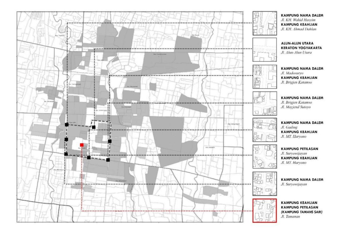
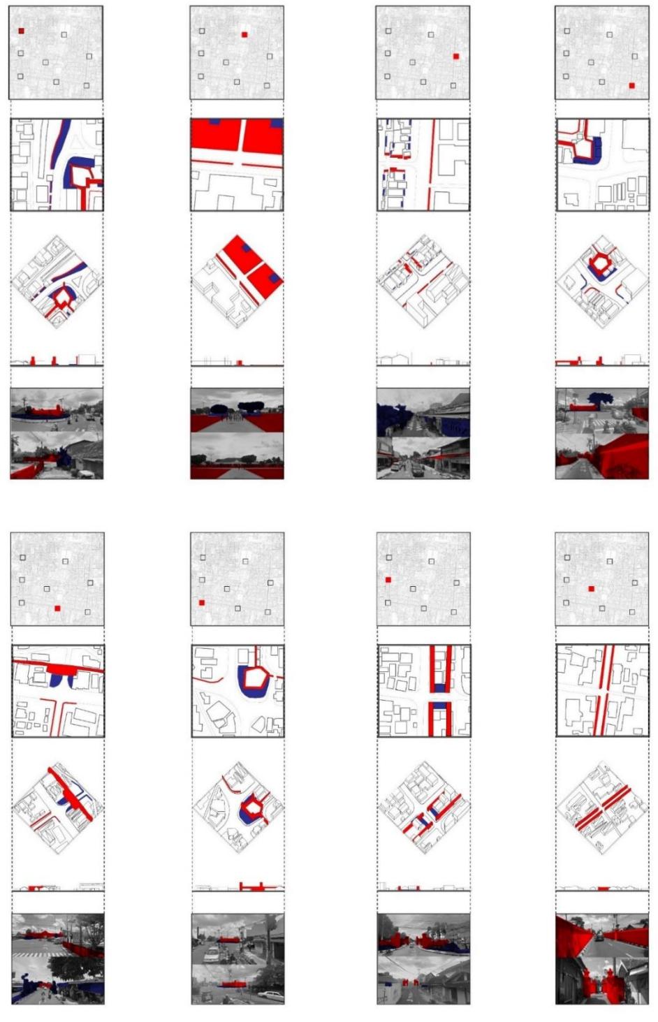
Figure 5. Kampung Taman Updated Map and Its Territorial Analysis focus on Corridor Structure. Source: Authors, 2020
The comparison between the older and the updated maps demonstrates slight changes in the silhouettes and shapes of Kampung Taman. Overall, minor coverage areas have grown by at least 5 to 10%, as calculated by Autodesk 2018. Eight samples located near Kampung Taman's main corridor are highlighted, exhibiting minor discrepancies with the previous map. They were investigated as part of the area's urban fabric, showing various marks of inhabitants' common perceptions. Some are taken seriously as landmarks, signage, limit, or boundary, while others are considered minor, but mostly the changes in the corridor network are believed to affect the kampung's new perspectives.
b. Territorial Analysis of Circulation Network
Beyond understanding the corridors as a circulation network for Kampung Taman, it is now possible to perceive it as the backbone for all communal activities. This indicates how territorial investigation may look beyond individual boundaries and take only the most fundamental structure of Kampung Taman. Also, a territorial analysis of Kampung Taman's physical structure explores how the corridors can be affected by or impact the surrounding environment. In this sense, the corridors can be categorized based on their hierarchy and type (Figure 6). Thus, they can be described as follows:
Figure 6. Kampung Taman Territorial Analysis on Circulation Networks. Source: Authors, 2018 1. The main road is located at the periphery of Kampung Taman; it divides Kampung Taman from other parcels while also connecting Kampung Taman's territory to the external environment, as illustrated by red solid lines in Figure 6. The inhabitants see this main road as a boulevard connected directly to other prominent city parcels. As an urban element, the road serves the surrounding neighborhoods, delivering people to and from the surrounding palace parcels and being the main road in Yogyakarta. In other words, it has a fundamental role, as it was designed locally for the highest level of trajectory, with two ways of delivery for both two-and four-wheeled vehicles (Figure 7), although the design may not be comparable with international standards.
Figure 7. Main road and entrance of Kampung Taman. Source: Authors, 2018 2. The kampung's main artery is a kampung corridor that delivers people into the kampung and connects the kampung to the main road, as shown by red dashed lines and dots in Figure 6. This corridor is aimed mainly at people, as the pavement functions mainly as a pedestrian road and is not intended to service four-wheeled vehicles (Figure 8). However, different perceptions of the inhabitants and the possibility of serving two-wheeled vehicles add to its function. This corridor allows carts, motorcycles, bicycles, and other vehicles. It is connected directly with a public area with latent potential for commercial purposes, including extending the kampung's territory to the outside domain, although the interpretation may differ for tourists or external observers.
Figure 8. A look behind the Kampung's wall. Source: Authors, 2018
3. Kampung pathways are categorized as tertiary; they are the kampung's local lanes and secondary branchings and can also be seen as footpaths (Figure 9). They branch off from kampung corridors and are mostly temporarily paved, while some are raw as they are mainly covered by soil or natural rocks. They are the youngest in development and construction and were made by new residents when dividing plots for new houses. The tertiary branchings can be interpreted as the latest internal extensions from the kampung network, proceeding from a dead-end passage or an additional branch where further improvisation is done.
Figure 9. Kampung Taman's Junction and Corner Perspective Samples. Source: Authors, 2018
After the hierarchy has been explained, the types can now be described: Kampung Taman is strongly defined by giant white walls at its periphery (Figure 7a). Due to the limited pedestrian area, some space was added to prevent direct vehicle collisions with the walls. In the hardscape, the wall is a boundary of the kampung, a physical boundary that separates Kampung Taman visually from the main road. Porosity is created to enter the kampung. The openings are 180 cm wide, facing one another across the road. Both visitors and inhabitants are suggested to walk on foot (Figure 7b), although an alternative can be using a two-wheeled vehicle. There is no limited number or particular procedure for any person per day to enter Kampung Taman. This massive wall can be perceived as a planning screen, a fortress, a secured wall, and a physical boundary of the kampung. At the same time, the semi-permeable openings also allow the kampung to extend its territory. The openings are prime areas for preparation and can be planned strategically for further interventions.
The situation behind the wall provides mutual openness to the opposite parcels, as the openings face each other (Figure 8). In the visual composition, the double-sided corridor is formed by various humble Javanese houses, with a typically semi-open facade and a terrace, a pitched roof, constructed by a wooden structure with a combination of brick and stone for its walls. The pavement of the kampung corridor provides a bold horizontal boundary on the ground, giving direction to visitors and inhabitants. The pavement indicates the public and communal territory while serving as the main access. There is a narrow gap between the pavement and private properties, either for public, communal, or private use. Some of them are defined by the inhabitant as leftover space and can be used for other functions. Others are left open for any interpretation.
A typical house can be seen in Figure 8. The house on the left has a facade consisting of a wall with minimal openness, while a curb was added in front as high as 15 cm, thus creating a plinth, a less visible boundary of the house; no fence is provided, potted plants are arranged on the side adjacent to the fortress wall to soften the boundary. The house on the right-hand side provides another expression of the territory. After a parapet was constructed, the owner allowed a communal graphic to be applied. Instead of bringing forward its facade close to the pavement, it was stepped back to create a terrace. Although almost all typical, the houses can be seen as individuals' gestures, exhibiting various territorial expressions, though always negotiable for communal and public engagement. This natural kampung expression differentiates what is usually applied in doubled-loaded corridors of any residential estate. A subtractive effect not only illustrates individual expression but also potentially creates a variety of solid volumes and voids in the physical structure, neglecting the uniformity of the typical facade while stimulating
opportunities for an additional function for those who live in or experience the corridor of Kampung Taman.
Different variations can be found at the junctions and intersections: signage, seating areas, and security posts are placed to provide careful attention, direction, guarding, and supervision. The typical terrace is mostly constructed to provide a gap between the corridor and the house. This prevents collisions and accommodates room for natural surveillance, as multi-directionality can be obtained (Figure 9). Another intervention is initiated by chiefs, elders, leaders, and administrators, providing plant arrangements, openings, or small gardens to soften the edge while at the same time providing a strategic space for gathering, as corners are easily reachable and can be seen from at least two directions at the same time. Corner territories are managed by a supervisor, which is also beneficial for providing communality. The supervisor may be a chief or community leader who is responsible for providing and maintaining suitable facilities in the kampung. Although clear ownership of corners may not always be found, the proprietorship is inherited from a kampung elder in some cases.
Javanese terrace houses dominate single-loaded corridors in Kampung Taman with a pedestrian pathway. Although the terrace and shaded pedestrian pathway are not always connected, their type and size may give a sense of continuity along the corridor. A typical high wall or parapet is usually constructed on the other side; others may be houses abutting the corridor with minimal top light or even windows (Figure 10). A porch, yard, or small port is a typical variation applied at the frontage or wings, while the opposite side is often empty or used as a parking lot or for potted plants and even chicken coops. It is an additional extension shared between neighbors. Some say this is based on the basic instinct to extend the boundaries of an individual's or a house's territory. Others believe that lower competition for residual space stimulates creativity in strategically benefiting from leftover space. An informal negotiation has been made by arranging goods beyond individual boundaries. However, this expression can be perceived as an intention to create additional space or initiate conversation between neighbors.
Figure 10. Single Loaded Local Path Samples. Source: Authors, 2018
There are no clear criteria for the types of materi al used. Expression is generally free when using leftover spaces, but one may need to ask for permission from a neighbor or chief and apologize when they have been managed incorrectly. This is why it is common for residents to use their house boundaries as the parameter for controlling the surrounding space, including setting a new territory division for using any remaining gap available. To those who live in Kampung Taman, it is an opportunity to widen their boundaries. They are generally free to express themselves, especially through body gestures in communal spaces. For example, residents can be willing to share the front of their house or yard for resting. Neighbors can negotiate when sharing leftover
space to place goods, parks, and other non-permanent and semi-permanent expressions in their leftover space as long as the space remains flexible. Flexibility in Kampung Taman may be understood as program fluidity, open expression, few fixed elements, unlocked potential, and adjustable functions and structures in leftover spaces, where the rules are controlled based on local norms and etiquette.
Regardless, the Taman Sari Palace entrances are not openings created by the Kampung dwellers and may affect Kampung Taman as commercialization creates magnetic attraction (Figure 11). Located nearby, Taman Sari Palace opens up the opportunity for Kampung Taman as a tourist attraction. Although, in general, the openings create a type of square, its main function is as a parking lot organized by the Taman Sari management. The 'squares' are connected and associated with Kampung Taman; boundaries are generally minimal. For example, plants, signage, flags, and rocks are placed to delineate the space, especially parking space. A sign indicates nonstandard parking, suggesting that the parking system is implemented informally. A space rental initiative is managed based on negotiations with the surrounding neighborhood rather than controlled by formal law. Parking varies between four-wheeled and two-wheeled vehicles and rickshaws or bicycles. Informal kiosks and food vendors also appear often and can be transported, changed, and even transformed randomly depending on local circumstances.
Figure 11. Corridors adjacent to the Taman Sari Palace. Source: Authors, 2018
A different gesture can be found in some residences surrounding Taman Sari Palace. The owners have applied great efforts to highlight the houses' boundaries by implementing a soft boundary. A three-dimensional composition was created by arranging plants, pots, statues, jars, temporary fences, bollards, curbs, decorations, markers, ornaments, and so on, to claim the actual boundaries. Although these interventions use humble materials, great effort has been made to filter, protect, and claim their private territory. This is probably based on the anxiety of penetration, misuse, and disturbance due to the frontal relationship between public and private domain. Unavoidably, commercialization affects their private territory. However, kampung residents tend to maintain openness to their homes as they consciously understand the importance of the Taman Sari site by choosing soft boundaries and providing opportunities for negotiation if users and neighbors request permission to use their property temporarily.
The territorial analysis regarding Kampung Taman's physical structure can be summarized as follows: firstly, the physical territory of the kampung cannot be interpreted by only using formal architectural theory. Although houses dominate the physical structure of the kampung, the corridor networks as communal spaces play a significant role in stimulating territorial activities. Kampung territory is physically implemented as a 'softscape' and temporary structure. However, it has the potential for continuous growth, change, and adaptation governed by local customs and norms. Although communal activity is prime, it is negotiated in a familial manner and follows the kampung's system. Territories can be changed unexpectedly and affected by external influences. However, the samples above prove a stable pattern.
In the case of Kampung Taman, the territory is not always indicated by physical boundaries, although the snapshot illustrates the physical structure of the kampung as a medium that stimulates participation. Undeniably, the house is the kampung's primary cell that generates the kampung's system; this is an essential parameter in understanding the kampung as naturally organized in a familial manner. Although Kampung Taman's territory is an expression of a culture, its architectural language may differ from other kampungs and informal settlements as it is regulated based on local norms and customs. This defines the uniqueness of Kampung Taman's territory. It is creative in solving local problems as programmatic, functional, and temporary, yet encourages various communal activities by elevating negotiation and consensus. The territory of the house is the most intimate domain and is not negotiable, unless for household members. These two support each other, forming a dialectic relationship and speaking a language expressed by using temporary materials and made portable and moveable so that changes can be made.
Conclusions
According to the territorial analysis, the map shows several changes in shapes, silhouettes, and coverage of Kampung Taman between older (made before 2018) and newer maps (made after 2018). Minor changes are visible in the new map, while overall shapes are generally similar to the older map, although it clearly shows that the kampung has been expanding. The corridor network serves as infrastructure and boundary for the kampung inhabitants; this is why their perception suggests minor adjustments to the calculation of nearby boundaries as part of the kampung's territory. The other difference is the perception of the hierarchy of corridors. Most inhabitants can differentiate and have a similar perception about the main road and main artery; they are both considered as boundaries of the kampung, although the understanding may be different for visitors and external observers. However, it is difficult for kampung inhabitants to categorize a corridor hierarchy within the kampung. Various perceptions and interpretations have been claimed based on their familiar territory, and boundaries are hardly defined by using exact locations or specific measurements.
Based on the territorial investigation, the territories of kampung inhabitants' are expressions of boundaries; it is an architectural language, a communication medium representing the arrangement of physical structures. This expression stimulates negotiations, relationships, and the protection of ownership. A new interpretation may be opened up because the expression is not always concentrated on the physical boundary. Spatial arrangements that construct a new territory can be seen as creative, programmatic, functional, and temporary based on 'communality.' A physical structure can be a cultural product without legal documentation or written agreement. Instead, Kampung Taman is governed by norms through verbal communication and self-critique; it is an expression of concern for others; it is planned for a limited time and in the anticipation of change. This is why both materials and properties are portable and moveable so that the opportunity for negotiation is always open. Thus, although the physical structure of Kampung Taman is generally considered soft, temporary, and portable, this is possibly the reason why the kampung is resilient, flexible, adaptable, transforming, and perpetually growing like an organism.
Acknowledgment
Thank you to DPPM-Untar (Direktorat Penelitian dan Pengabdian Kepada Masyarakat-Universitas Tarumanagara) for funding this research.