
Introduction
The establishment of a city may be the act of a great chieftain, the result of community development, simply organic growth, or the result of someone's impulsive actions. In view of this, we may get a better idea about the causes of the current crisis in metropolitan landscape planning by exploring the genesis of early cities (Bosselmann, 2008; Jim & Chen, 2003; Kongjian, 2011; Moughtin, 1996). Early cities experienced the easy-going life of rural society, which was to a great degree democratic but has now been replaced by much more intricate social clustering. As a result, cities are related to a class of professionals who are not interested in cultivation and favor naturalistic forms of art, science, craft, and specific trades (Howard, 1965; Umar & Yusuf, 2019). Consequently, landscape configurations and urban planning have emerged that were carefully designed to reflect the hierarchy in the community and to create a suitable environment for religious rites (Umar, 2008). As such, they are tangible expressions of satisfaction in personal achievement and the desire to have a guaranteed home for the future.
Orientation and reference to the physical landscape were principally significant in setting up early cities. The components of the dwellings were also organized to concord with the local surroundings and the forces of nature (Olofin, 1987). Wheatley (1971) revealed that the planning of Chinese cities emphasized the quest to link the natural surroundings with the built environment. Over a hundred years ago, the model plan for the city was systematized in a philosophy according to which a city must be oriented correctly and arranged in square and rectangular patterns. Whereas a great emphasis was put on accessibility through gateways and approaches to encircled areas related to cardinal points, the importance given to the orientation as well as a symmetrical composition were applied to maintain a balance between right and left (Boyd, 1962; Do et al., 2018; Moughtin, 1996).
The complex correlation between urban morphology and city landscape has expanded into an obscure geomancy for environmental planning. The prehistoric geomancy feng shui is presently practiced in Asia. Famous business individuals in Hong Kong adopt advice from local specialists in this Chinese geomancy for the design of residences as well as workplaces (Lip, 1989).
Urquhart (1977) claims that the city landscape is a massive collection made up of thousands of different elements which, when placed into ordinary surroundings, form obscure patterns. These elements are planned or ignored by individuals or groups of people. Meanwhile, Yusuf (2016) states that the city's surroundings consist of a rural area that is not yet considered a town or city while the built-up area and the urban landscape form patterns that reflect the physical environment as well as the attitudes and necessities of urban civilization.
According to Yusuf et al. (2023), most studies on urban space in major African cities (Abass et al., 2019; Abdulraheem et al., 2022; Barau et al., 2015; Gelo & Turpie, 2021; Moussa et al., 2022; Woldesemayat & Genovese, 2021) focused on a common preservation approach that falls short in exploiting the adaptive process of previous eras or the emerging landscape index approaches of modern times. One of the commonalities of these studies is the assessment of spatial depletion and the accessibility of urban space using several approaches. However, they failed to correlate the evolutionary practices of selected regions to explore the principles that affect layout formation, processes, and phenomena, and to identify the key enablers of the underlying planning mythology. The present research attempted to fill this gap.
Although the origins and history of the Hausa people are obscure, according to Umar (2008), they can be traced back to their great ancestor Bayyajidda, the founder of the Habe Kingdom. Historical records of the Habe cities reveal four phases: the early Habe Dynasty (15th to 18th century), the Fulani Empire (18th to 19th century), the Colonial Period (1900 to 1960), and the Post-Independence Period (1960 to date).
This study adopted the 'origin-pattern-function' of landscape development as the central framework (Figure 1) to conduct a systematic study on the evolution of open-space landscape patterns in Hausa cities. Other studies (Bernard et al., 2018; Hang & Ang, 2019; Şenik & Uzun, 2022; Umar et al., 2019b; Yusuf, Zhu, et al., 2023) were used to construct the framework in question. Further literature on the framework can be found in Feng (2014).
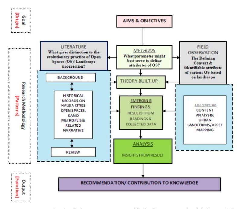
Figure 1: Component appraisal of the open space (OS) framework. (Adapted from Yusuf, Ahmed, et al., 2023; Yusuf, Zhu, et al., 2023)
More specifically, this study sought to answer the question: What is the open-space landscape cosmology of Hausaland and what were the key enablers of this mythology in Habe cities? This study aimed to explore the embedded landscape cosmology in Hausaland and its related historic mythology with the intent to preserve knowledge for the present and prospective generations. More specifically, the objectives were: (i) to authenticate the basic concepts and practices of outdoor spaces in Hausa cities; and (ii) to identify the reasons for this landscape philosophy.
2.0 Materials and Methods
As cities are open to survey and evaluation of their planned landscape, this study purposively selected an example from northern Nigeria. There, urban activities have extended over broad areas and over several centuries (Denyer, 1978). More precisely, the cities themselves had ample space to expand throughout their extensive histories. Different cultural groups and urban ideas from various sources have added to their development (Moughtin, 1985). Urquhart (1977) further maintains that the planned landscape of the cities of northern Nigeria "was not swamped by rapid transformation nor fraught with competing plans and thus stand asreally distinct and identifiable".
Figure 2 depicts the heartland of the Habe cites, situated between the river Niger and the river Benue in northern Nigeria. The cities include Kano, Jigawa, Katsina, Daura, Zaria, and Gaya to name a few (Umar & Yusuf, 2019; Yusuf, Ahmed, et al., 2023). The urban tradition of Habe cities extends back over centuries, possibly more than a thousand years. Some cities have subsisted in their current sites for more than four hundred years, such as Kano, Zaria and Katsina, which date back to the early Habe Hausa Dynasty, (Home, 2021; Urquhart, 1977). The diversity embedded in the configuration of these cities was created by various individuals or families of different origins, classes and occupations, while the centrality of the township is shown by their grouping together for security, trade, and religion, with a bureaucracy led by an emir or king (Fisherman, 1977; Umar, 2008). Before the 19th century, and often under Fulani governance, most Hausa cities displayed large similarity in the natural growth of the urban landscape along with sources of welfare, means of exchange, transport, and government as well architectural, agricultural and land tenure practices, which all contributed to the specific characteristics of Hausa cities (Barkindo, 1989).
The urban landscape of modern Hausa cities as a collection of traditional open spaces has gone through several transformations under the influence of Islamic and British colonialists and changes in landscape form. More recently land development policies have left their mark.
This study employed a descriptive research and review approach. Ndagi (1999) states that descriptive research entails data collection for the purpose of examining and explaining prevailing practices, existing circumstances, attitudes, reasons, and on-going processes. Nevertheless, the main reason for using a descriptive research method is not only to explain what but to clarify what is being discovered. The review process involved re-evaluating previous studies on spatial patterns in Hausaland by focusing on the reasons for this landscape configuration in order to enhance past and future research.
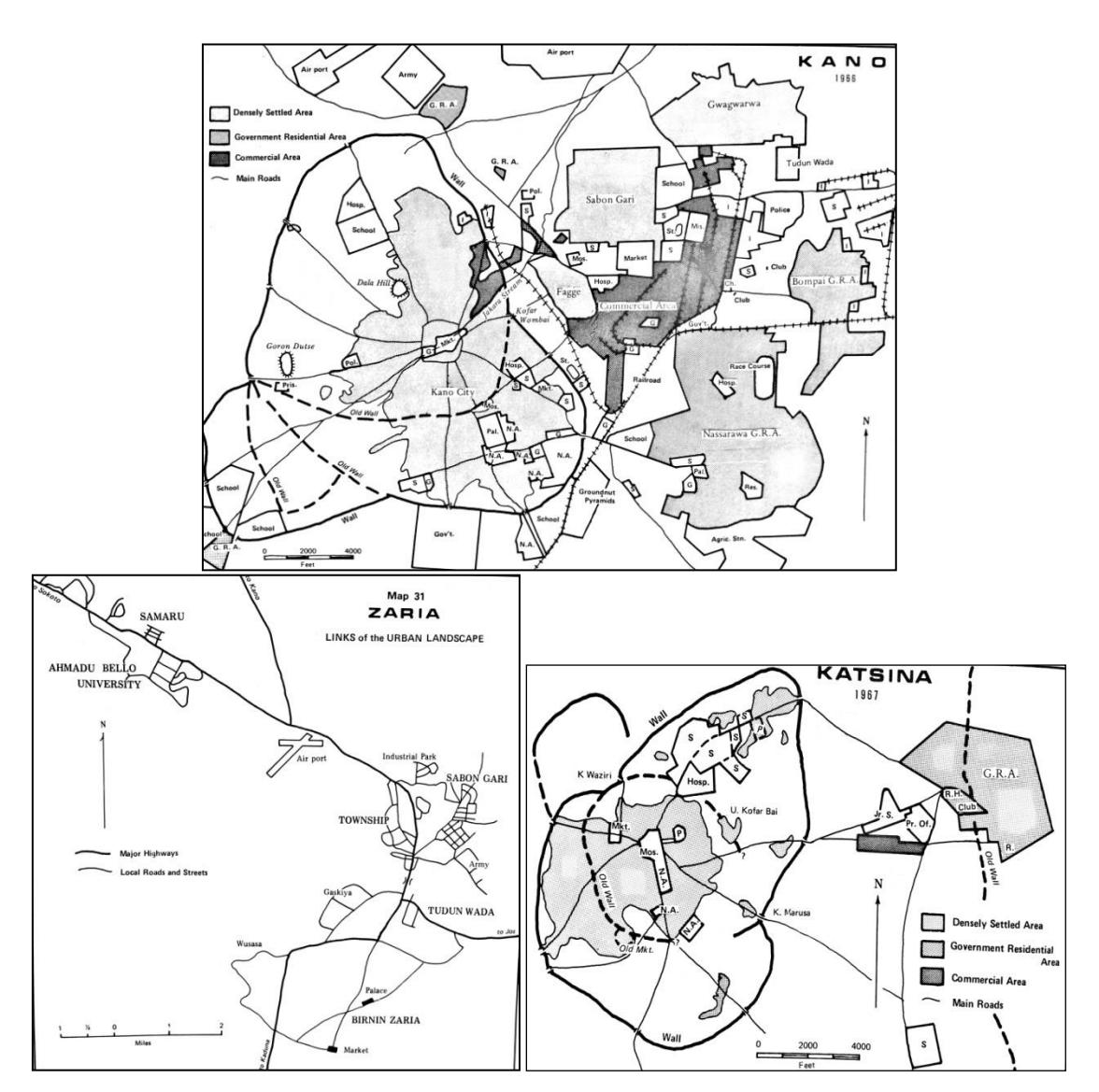
Figure 2: Hausa city and landscape maps. (Source: Urquhart, 1977)
3.0 Theoritical Context and Analysis
3.1 Pre-Islamic landscape cosmology in Hausa cities
According to Urquhart 1977, the origins of urban centers in Hausaland are obscure, even though the early development of the birni (city) can be traced back to the period of the Habe Hausa Dynasty (Umar, 2008). The development of the birni, according to Brinkmanna et al. (2012), was because of immigration of groups of people and individuals to centers of attraction rather than simply the natural increase of a community. Therefore, the development of the birni was linked with the political status of the city states of the Habe kingdoms, among which Kano city was one of the largest commercial centers in northern Nigeria.
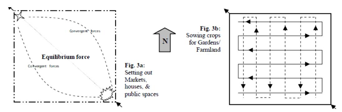
Figure 3. Pre-Islamic geometrical ritual landscape in Hausa cities. (Adapted from Moughtin, 1996)
Figure 4: Pre-Islamic landscape cosmology in some Hausa cities. (Source: Umar et al., 2019)
Fisherman (1986) revealed that in the traditional pagan Hausa epoch, old cosmologists authorized the design of open spaces, residences, stockpiles as well as towns. In this pre-Islamic mythology of the Hausa people, the southern and eastern cardinal directions were male, while the northern and western ones were feminine, Thus, the four cardinal directions were categorized into two gender components (Moughtin, 1996). Moughtin further maintains that the open spaces were likely a sphere of convergent and divergent forces (as illustrated in Figure 3a) that maintained a delicate balance. Setting out an open space (a residence, a marketplace or a town) according to specific spatial rituals attempted to retain this balance through the forces of the space. As such, ancient Hausa spaces were square or rectangular, mostly in the north-southeast context, while crops were sown in a rectangular outline. In farms, sorghum and millet were sown in strips perpendicular to each other. Millet was seen as a masculine crop due to the phallic shape of the seed and sown in an east-west orientation while the female sorghum was sown in a north-south orientation. Millet and sorghum germinated after this matrimony (see Figure 3b).
Dwellings, formally all with cylindrical walls and conical roofs, were oriented along the four cardinal directions. Mortimore (1970) pointed out the significance of large granitic outcrops rising sharply from the plane: the black hills of central Hausaland were seen as the dwelling places of great sprits, iskokai. The presence of iskokai may have attracted migrants from foreign areas (illustrated in Figure 4). This religious attraction of the hills, their greater defensibility, and their more constant water supply than the surrounding planes make it easy to see why most hills were inhabited at this time or any other (Perchonock, 1976).
3.2 Pre-colonial landscape cosmology in Hausa cities
At the beginning of the 19th century the nomadic Fulani under the tutelage of Usman Dan Fodio declared a jihad (holy war) against the Habe Hausa Dynasty and conquered almost all of Hausaland and some parts of Borno and Sokoto (Fisherman, 1986). Little hamlets, including
Gombe, Wurno, Gwandam and Katagum, came to significant power between 1805 and 1818 after being raised to the rank of major administrative urban center. When the Fulani Empire established its influence over the region, the effective central administration of the sultanate brought about relative peace and prosperity.
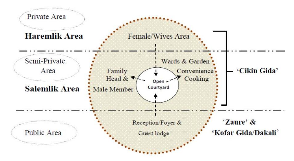
Figure 5: Typical Hausa residence pattern/formation. (Source: Yusuf, Zhu, et al., 2023)
Islam has no doubt influenced the layout of the compounds, particularly in the urban areas of Hausaland. Polygamy and different modes of religious marriage laid great emphasis on complete privacy or the partial seclusion of women, which requires a high degree of privacy combined with a genuine desire for security (Sa'ad, 1986). In Islamic architecture, purdah (seclusion of women) means there are salemlik (accessible) and haremlik (less accessible) areas (as illustrated in Figure 5). The courtyard connects three common space matrixes (household, social activities, and kitchen/dining), with the kitchen located at the back of the courtyard, joined with or separated from the dining area in an open space or parlor (Umar et al., 2019a; Umar et al., 2019). The latrines or toilet are also placed at the extreme end of the courtyard for hygiene, seclusion, and other reasons.
More so, a typical traditional Hausa residence is subdivided into three allotments: the outer core (public areas), the central core (semi private area), and the inner core (private area), while the need for privacy is stressed in every compound (Popoola, 1984). As such, the hierarchy starts from the entrance room (kofar gida and zaure), which serves as a guest reception area and functions as a link between the inner court (tsakar gida) and the public world of the street (waje/kofar gida). The cikin gida is the most important part of the compound, open only to the compound head and male and elderly members or relatives of the family. Within the cikin gida there may be household units organized in such a way that no-one can transgress the privacy of others. Moreover, Umar (2008) stresses that the courtyard is an area where the household spends much time, either involved in everyday activities or in ceremonial or social activities. It also serves as a playground for the children, where they can play and move around undisturbed. One may also eat and chat there with family members or sleep there on hot nights or special occasions.
3.3 Urban and rural cosmology in Hausaland
The delineation between rural and urban landscapes in Hausaland is not strict, since individuals usually see the urban landscape as part of the adjoining rural surroundings as well as their daily lives, called anguwani, similar to the rural landscape (Perchonock, 1976).
In 1984, Popoola noted that "the rural setting is bounded by nucleated hamlets, with some isolated courtyards". The isolated and dispersed compounds are related to a village, having a great link with some nuclear hamlets not far from such a dispersed village.
The following are three typical Hausa settlement structures, listed in hierarchical order:
- a. 'Birni' (city) refers to a metropolitan nucleus inhabited by individuals or diverse groups who settled into an area. It was usually a fortified settlement. The surrounding defensive wall was an important aspect in the appearance of the ancient cities. The walled city protected agricultural land inside of it in case of prolonged attacks against the birni. In most cases, the birane (cities) were hubs of commercial activity, executive power, or the political seat of axial cities of the Hausaland. Sa'ad (1986) notes that "The 'Birni' or 'Gari' is conceptually and geographically classified into three parts: 'Cikin Gari' (inner core), 'Tsakiyar Gari' (central core) and 'Wajen Gari' (outer core), bordered by 'Ganuwa' (city wall), mostly a thick mud wall. It is accessed through the 'Kofa' known as the city gate".
- b. 'Gari' (township) refers to a large settlement, structured as a metropolis, surrounded by distantly-related family groups and various outsiders. It usually had a collection of anguwanni (wards) with common religious and occupational roles or based on family ties. The two other aspects related with the growth of garuruwa (towns) were: (i) the existence of broad fertile agricultural lands for cultivation; (ii) places chosen based on religious considerations. Some places became hubs linked with an iskokai (encampment of certain forces) and hence involved larger numbers of settlers, which created garuruwa (Perchonock, 1976). Meanwhile, a gari (town) had no fortification, because "the defence walls of some Garuruwa were related with warfare post-dating the basis of Hausa township".
- c. 'Kauye' (village). Kawauyika (villages) only existed in rural areas. Umar et al. (2019) state that a metropolitan dweller would usually despise being called bakauye (villager), which was fundamentally a group of patrilineal family clusters in a nuclear settlement, prearranged for farming, where gona (agricultural land) was unconnected to and contiguous from other kawauyika (villages) by daji (bush-land).
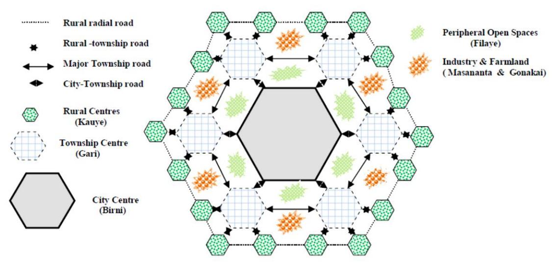
Figure 6: Urban and rural landscape configuration in Hausaland. (Source: Author 2022)
Every city nucleus consisted of a large centrally designed place surrounded by individual units, many small and almost identically organized (see Figure 6). This cosmology demonstrates that the model of triple open space in the Hausa city landscape is identical with the traditional family dwellings encircled by a compound wall with a doorway and a city wall with a gate opening. The reason for this polygonal shape was for security during the pre-colonial era and ancient ethnic wars, with gates for the accessibility of the network of precincts within the walled city.
4.0 Discussion
This study aimed to reveal the historic mythology of the open-space landscape of Hausa cities. The Hausa Fulani were a different but culturally identical ethnic group, co-existing in northern Nigeria (Umar & Yusuf, 2019). In this context, Hausa Fulani culture contained assumptions about ways of living that indirectly gave form to towns and cities. Gari (singular) and garuruwa (plural) refer to towns, while birni (singular) and birane (plural) refer to walled cities (Umar et al., 2019; Urquhart, 1977). Figure 7 maps out the agricultural land and cities of the Hausa Fulani in northern Nigeria. As such, agriculture played a basic role in their culture, even within the major cities. At the same time, this agricultural society also contained a large number of craftsmen, traders, and specialists. A centralized bureaucracy united these differing elements into a political whole, which was reinforced by a common religious heritage, partly indigenous but now largely Islamic.
4.1 Agriculture
Farming in Hausaland sustains an economy with ample surplus to maintain a large nonagricultural populace, even within the more urbanized parts of Hausa cities. Crops and cultivation systems are very varied and the result of a complex supportive economy that developed over hundreds of years (Dankani, 2013).
Areas far from a town or city when they have not been cultivated for many years are known as daji (bush), although the vegetation indicates that they have been grazed over or farmed sometime in the past and are now probably a major source of firewood. Even the more remote rocky outcrops contain plant cover that can be interpreted as having been disturbed by human activities (McDonell, 1964). Open space nearby or within the town walls is farmed all year round and fertilized by waste from the city. Beyond the fields farmed annually is a belt of land cultivated under a form of rotation cropping, where cultivation trees are left to grow because of their valuable fruit, bark, or timber. Other trees are planted in the compounds and in the annually cultivated fields, giving a unique appearance to each part of the farmed area (Pullan, 1974; Yusuf et al., 2017).
Periodically flooded land, called fadama, lies along streams and rivers. When irrigated during the dry season, it is an important addition to the farmland, especially in areas with a dense and increasing population. By using these formerly less-valued lands, farmers are now able to extend the agricultural year and the crop list by growing vegetables, sugar cane, and manioc during the dry season. Near the cities, fadama fields are increasingly important for growing high-value crops for urban markets.
Laterite crusts, eroding gullies fringing the streams, bare rock outcrops, and areas reserved or converted to other uses comprise most of the neglected land within the urban regions.
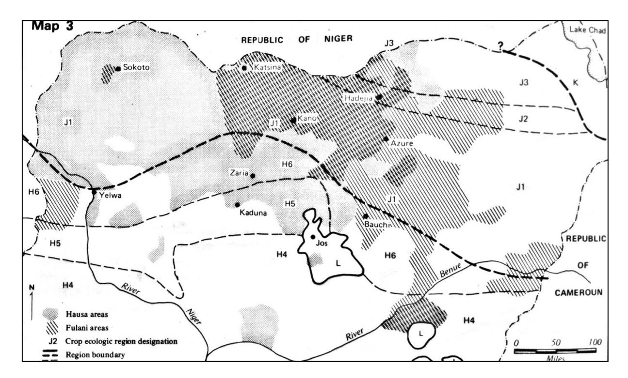
Figure 7: Map of Hausa Fulani cities in Northern Nigeria. (Source: Urquhart, (1977))
4.2 Trade
Trade and associated craft industries brought people of various origins together in the Hausa cities. Local trade routes linked the cities, towns, and villages of Hausaland, with the Yoruba and Nufe cities to the southwest, Borno to the east and the western 'Sudanic' cities (see Figure 7). Trade, effective political organization, and defensible locations attracted immigrants, like land shortages, family disputes, and warfare created emigrants.
The concentration of activities in the densest hamlets within the old Hausa cities generated a blend of permanent and temporary stalls, shelters, shops, and stockpiles. The housing density was greater near the market. The presence of multi-story houses, fewer farms, and smaller compounds with fewer courtyards exemplify the buildings crowded along the paths leading to the market (Denyer, 1978).
4.3 Administration
The centralized bureaucracy of Hausaland is ancient, as revealed by the common use of the same Hausa language titles of officials in separate, independent city-centered states. The head of the state and of the administration is the emir, who is also commander of the army, chief of all markets, and defender of Islam. He is chosen by a group of officials from one or more families eligible to rule.
The defense wall and associated ditches built and maintained as one of the emir's responsibilities as defender of the state, sharply define the Hausa cities (Muhammad-Oumar, 1978). Consequently, the immense mud fortification, 20 to 35 feet tall and with fortified gates, was capable of keeping cavalry forces and foot armies as well as informal raiders at bay. As such, it could well endure long sieges because the walls enclosed a large territory of farmland, steady
sources of water as well as stored food provisions. Rocky or laterite-capped hills such as Dala Hill in Kano, were sometimes included within the walls as a last line of defense (Umar et. al, 2019; McDonell, 1964; Olofin, 1987). The emir's palace with associated offices was a major focus of urban activity. This area required access to gates and roads to the outer districts of the emirate. It also had to be close to the Juma'at (Friday) mosque, so that the prayers of the emir could be seen as a symbol of his religious position, and it had to front an open space where the emir could receive the salutes of his officials and his people on ceremonial occasions. The native authorities (more recently the local government authorities) and the Alkali courts were centrally located along with the prison, police barracks, and local markets (Fisherman, 1986). The residential compounds of the ruling families and officials and their retainers were grouped in this secondary concentration of the traditional urban settlement.
4.4 Religion
Hausa religious tradition provides rites for establishing cities, markets, and houses as well as reasons for building on particular sites. Similar rites were used to determine the layout of the emir's palace, which was arranged in a rectangular pattern (Moughtin 1989). Butchers, a hereditary group of low status, by their profane sacrifices (slaughtering animals to nourish old gods) formally established markets (kasuwani/kasuwoyi). Perchonock (1976) describes some of the rites that were used during the pre-Fulani emirates of Kano, Katsina, Maradi, and Zaria to name a few.
The physical effects of Islamic practices are still easily visible in the landscape of Hausa cities. For example, the presence of the Juma'at mosque, usually nearby the palace and the market in the center of each city or town, while a large communal prayer ground is usually located outside the city walls for the Eid prayers. The practice of purdah, the seclusion of women, established by Islam but only widely accepted in cites after the pre-Islamic era, resulted in an enormous degree of suburban privacy and partially explains the internal orientation of the walled courtyards in the residences. These landscape forms are basic elements of rural settlements adapted to an urban setting.
5.0 Summary, Conclusion and Recommendations
Government policies together with the natural or traditional landscape in Hausa Fulani have resulted in walled cities, inspiring a compound pattern that incorporates agricultural lands as well as usually a rocky hill. This cosmology expresses the idea of triple open space or hubs in a traditional family residence, similar to the model of cities bordered by a wall with a doorway and a city defense wall with a gateway.
Physical forces of nature shape the landscape, which is modified by human interventions. Even though not fully under man's bearing or control, it can also be predictable. A third set of forces, attentive planning, structures both these types of landscapes in land defined as designed landscape.
This reveals that the model of the planned landscape when applied to an urban place should not be confused with the concept of a townscape or cityscape that carries the specific connotation of buildings, streets, trees, gardens as elements of the city landscape. Nor should it be confused with a city planner's setting as revealed in maps and descriptions, which are generally much more specialized and highly professional views of what should or may come to be an urban landscape. This urban pattern still co-exists in some cities, such as Kano, Katsina, and Gaya to name a few. Although the polygonal structure has been transformed into an organic shape, Kano for example
has kept its city center as central hub, triple open spaces, and a polygonal city perimeter encircled by a wall with a gate. Subsequently, Kano city is an undisputed case study of the evolution of the walled Hausa Fulani city for the reason that so much of its urban landscape can be correlated with the traditional planning cosmology, although further mapping and evaluation are required because of the frequent transformations taking place. The urban landscape of Hausa cities has gone through some alterations, from the clustering of the traditional morphology to the Islamic and British colonial landscape configuration. More recently regional development policies have also left their mark.
In conclusion, this study proffers important measures to help the society, government, and environmental specialists to authenticate the basic concept of outdoor spaces and related practices in Hausa cities alongside a contemporary scheme during the current period of rapid urban expansion. We have provided some reasons for this cosmology by identifying its key enablers. Consequently, the development of the urban landscape of Hausa cities is known to have established a systematic and significant result, in which the method does not only relate to individual spaces but also to communal landscape features. The following recommendations are offered for adoption by communities and the government:
- 1. Landscapes are constantly altered as a consequence of changing policies. When this happens at a slow enough pace, plans may be consented to as they can also be when land of all types is adequately available. With established and homogeneous traditions, the processes of urban expansion are tidy and reflected as 'natural' or 'right'. Meanwhile, with absolute control over street blocks and plazas, owners of private property, politicians, and the country's leaders may be able to enhance the city landscape authorized by regimented civil policy or quasi-religious faith-based principles.
- 2. Landscape planning is a process of constant alteration, and usually comes with dissonance or absolute disagreement when suitable terrain is sparse, especially when desires and requirements are many. When there are neither public guidelines nor natural practices, complicated mediation measures have to be invoked if disorder is not to prevail.
- 3. Where there are more members in the arbitration or planning panel, more different views arise, more planning conflicts will occur. Per se, professional landscape architects should be key decision makers in such developmental programs.