
Introduction
Not only urbanization and the presence of industry cause the rapid development of cities, but people moving from rural areas to urban areas and the increasing needs of the urban population also contribute to this growth (Mahtta et al., 2022). Urban development changes urban situations from one state to another in different periods, where conditions advance, improve, or enhance something already existing (Surya et al., 2021). High population growth, rapid expansion of cities, high rates of urbanization, increased economic development (especially of industries), modernized services, and large-scale trade reflect the factors influencing urban development (Mahtta et al., 2022). Further, researchers (or experts) have stated that Socal, national, and even global economic development inseparably shapes the development of cities (Lai, 2020). Another thing is that development concentrates on physically providing infrastructure networks, such as networks of roads, cables, pipes, and rails for the movement of people, goods, energy, water, waste, information, and entertainment, thus enabling companies and households to gain access that is more practical for production, distribution, and consumption (Hasyim, 2018). Therefore, urban development has several driving factors depending on the context of each region.
Economic factors drive urban development because cities offer more economic opportunities, attracting additional labor from rural areas, non-urban regions, and other large cities. For example, the desire or demand to increase production is greater among companies in urban areas, thus demanding an increase in the fulfillment of basic needs such as clothing, food, and shelter to support the increasing population in these urban areas (Mahtta et al., 2022). This land development phenomenon occurs due to its location within an urban region and the areas that influence it (Atharinafi & Wijaya, 2021; Kurnia et al., 2022). This can be due to being located close to a transportation system, natural resources, or the emergence of economically profitable centers of activity, thus impacting the physical development of such areas and the city. In other words, the unavoidable transfer of land functions results in change. Land on a city's outskirts that previously had an agricultural function will eventually change to non-agrarian land use (Hassan et al., 2020; Wijaya, 2015). Urban development has significant implications for the supply and demand of urban land.
When viewed from the urban land development process, land-use change and intensity can be physical and non-physical (Gore & Nicholson, 1991; Zuo et al., 2022). Physical aspects are builtup areas, and changes in land use are significantly related to land use specific to urban areas (Winarso et al., 2015). Built-up areas grow and develop from simple to more complex, or the functions of buildings in them change from simple to complex or vice versa. Meanwhile, the aspect of land closely related to its use in urban areas is the condition where the boundaries of land development develop from a smaller to a wider land use or vice versa. These two physical
aspects directly relate to land ownership status before and after a certain period. In addition, according to Lai et al. (2022), a non-physical element is the land development process caused by factors involving various development actors or agents in the political and socio-economic context. Economic factors affect land market mechanisms, which impact land development, especially the supply and demand of land. Land supply and demand are closely related to the quantity of available land (Dai et al., 2022). According to De Vries (2022), administrative factors influence legality, institutions, land administration procedures, formulation of land policies, and their implementation. Also, political factors are affected by the social and political conditions in a region (Guntur & Kurniawan, 2021).
Most studies on urban land development focus on urban mainland and coastal areas (e.g., Hudalah et al., 2013; Kurnia et al., 2022; Zhu & Simarmata, 2015). However, few discussions exist on land development processes in urban river areas (Padawangi et al., 2022). For example, land development and land-use changes in urban areas have also occurred in Palangka Raya City. The city, which at the beginning of its development originated from Pahandut Village, a settlement on the banks of the Kahayan River, was inaugurated by President Soekarno on July 17, 1957 as the location for the capital of Central Kalimantan Province, covering an area of 2,400 square kilometers with a population of 600 people (Guntur, Kurniawan, Sutanto, et al., 2023; Riwut, 2018). The construction of city infrastructure, office facilities, and employee housing began to be carried out massively due to this appointment and after Central Kalimantan got its development funding from the Central Government in 1959. Meanwhile, land under customary ownership or traditionally belonging to ancestral families in the village was donated as agricultural land for city development (Guntur et al., 2024; Riwut, 2018).
Along with the increase in population and city activities as a center for social-government services and the economic sector, the development of built-up land has been expanding beyond the initial development area until now. The government's involvement in urban development shows that since the 1960s, the government has implemented various urban development programs in Palangka Raya City (Guntur & Yunitha, 2020; Silver, 2007). However, the development of builtup land, especially in urban areas, needs to be optimally managed, while the impression exists that the government is just letting these areas develop independently. As a result, the Old Town area along the Kahayan River, including the Flamboyan, Danau Seha, and Mendawai areas, became an area for squatters in great need of being managed more appropriately. The Old Town area occupies the banks of the river with a shallow land topography, so floodwaters inundate this area during the rainy season or at high tide (Guntur, Kurniawan, & Sutanto, 2023). To anticipate this, residents of the area have built houses or buildings of a certain height using wood as the primary building material. This material is cheap and easy to obtain in Palangka Raya City and enables fast construction (Guntur, Kurniawan, & Sutanto, 2023). According to the legal aspect, the local government designated these areas as green belts (Mayor Decree No. 10 of 2003). This determination was mainly due to the unfavorable conditions in the area for constructing infrastructure and buildings.
Another thing related to the aspect of the buildings' safety is the high frequency of fires that occur, while it is challenging to conduct rescue operations and extinguish fires because of the high building density. The designation of these areas as green belts has been enforced only in certain areas. Because the community legally owns some of the land in the area, development in this area by the community is inevitable and even spreads to the areas designated as the Green Line. The built-up area is increasing but still limited to the old location. Water (big rivers) and primary arterial roads bound the land on the left and right, which causes built-up areas to develop within these physical boundaries. However, because of their location in the city center, these areas are profitable and in demand by certain groups. From 2005 until now, development has even expanded across the river.
Formal and informal development processes shape land development, and physical and nonphysical factors can drive these processes (Rakodi & Leduka, 2003, p. 8; Rakodi, 1994, p. 70; Winarso et al., 2015; Zuo et al., 2022). The physical aspects are built-up areas (buildings and infrastructure facilities), boundaries of built-up areas, and location factors, such as swamps and riverbanks, for example in the Old Town area. Meanwhile, non-physical aspects, such as economic, social, and political factors, affect the land market mechanisms, land status, supply and demand of land, as well as the price and value of land, which are also related to the land-use pattern (Adams, 1994, pp. 17-19). However, formal land development is not functioning as it should; informal land development seems dominant (Rakodi & Leduka, 2003, p. 10). One of the consequences is the emergence of buying and selling transactions related to land in the area that proceed without supervision from the government. Meanwhile, occupants of the area alternately reside in the area (land transfer) with the same living conditions and tend to become squatters, especially in the Old Town area. Departing from this phenomenon, the problem that was the subject of this study was to see how far the land development process in Palangka Raya City, especially in the Old Town area, can be viewed from physical and non-physical factors, both formal and informal, and its relation to the development of infrastructure needs in the area.
The development of a city, influenced by both economic and non-economic factors (Healey & Ilbery, 1990; Lean & Goodall, 1983, p. 174), demands an adequate land supply and management system (Mattingly, 1994) so that planning and management of urban areas become more effective and efficient (Firman, 1998). This study aimed to explain the physical and non-physical factors that drive land development in the Old Town area in terms of the conditions of the built-up area as well as the development of formal and informal land. Researchers expected the research to enrich the body of knowledge in the field of study, especially concepts regarding cities' expansion and spatial changes in the context of the land development process. In addition, this research aimed to provide scientific enrichment regarding land development and the factors that influence it, especially in river-based urban areas. The researchers hope policymakers will use the results of this study as input and consideration when determining policies related to the planning and development of the city's land, especially for the municipality of Palangka Raya.
Contextual Considerations
Land Development Concept
We can divide land into formal and informal categories based on typology. Formal land means the government administratively permits formal land ownership, pertaining to state-owned land as well as land used for public and social service facilities. The government provides infrastructure such as roads, bridges, electricity, and other facilities on this land. Meanwhile, informal land is land that people use for non-commercial activities, such as land for shifting settlements, government-owned land that migrants invade in restricted areas, land that squatters occupy in marginal areas, and land that falls outside urban allocation areas (van der Linden & Baross, 1990a).
Developers can divide land development into five approaches based on the related processes (Carmona et al., 2003). The first, the equilibrium approach, assumes that economic structure development emphasizes effective demand that reflects rents and yields. This is a development model based on neo-classical theory. Second, the event-sequence approach focuses more on the management level in the development process. This concept originates from estate management and guides the implementation of the development process. Third, the agency approach emphasizes actors and their interactions in the development process. This concept was developed from a theoretical point of view to describe the process of creating behavior or from an institutional perspective. Fourth, the structural approach focuses more on organizing the relationships in the development process and what causes their dynamics; urban politicaleconomical factors form the basis for this approach. Fifth, the institutional approach describes events and agencies to explain the relationship between both influences more comprehensive structural systems imposed from the outside (Healey & Ilbery, 1990). The first three approaches use different influences to analyze the actors and institutions operating in the land commodity market structure, supply, and demand. Meanwhile, the fourth approach bases itself on the theory of the structure and dynamics of these commodities, considering both production and changes (Healey & Ilbery, 1990).
Land Development Process
Based on the terms, we can divide the concept of 'land development process' into three parts: process, development, and land. A process uses a series of related things to achieve results (Stevenson, 2010). In addition, one can interpret a process as a series of events that produce change or development. Meanwhile, Jayadinanta (1999) states that development is advancing, improving, or enhancing something already existing. A definition of development is an action to increase or make something more significant in size, number, and importance (Stevenson, 2010). On the other hand, people can also interpret development as expansion. Meanwhile, land has an allotment and generally has an owner, either an individual or an institution (Jayadinata, 1999). Land is also used for specific functions in cities and villages (Stevenson, 2010). Thus, based on this conceptual analysis, we can conclude that a series of events and actions constitute the process of land development. These events and actions enhance or expand land that already has a designation, whether owned by individuals or institutions, in an area used for urban and rural purposes. This expansion occurs in size, number, and importance.
Concept of Formal and Informal Land Development
Land refers to a commodity that requires a process in its development. The land development process is informal and formal in the context of social behavior and the relationship between the actors who use the rules contained in the process. In the social context, relations resemble a relationship between subject and object as long as an oppositional philosophy bases the relationship (Lefebvre, 2003). Meanwhile, other opinions classify relationships in the context of social behavior in two relationship reviews according to Rakodi & Leduka (2003, p. 11).
- 1) Structure and agency, defining the rules needed for a social system to exist and function, we understand rules as general techniques or procedures that follow laws or facts emerging from social practice (Giddens, 1986). Meanwhile, the fact that urban land development must be connected to development agents gives rise to agency. Development agents tend to act as rulers who have the power to do anything (Giddens, 1986).
- 2) Institutional analysis (IA), or New Institutional Economics (NIE), arising because of dissatisfaction with the basic assumptions of (neo-classical) economic theory, which adheres to the traditional factors of production (workers working in a field, capital, and entrepreneurship) in that location, even though economic growth will also depend on rational considerations or maximizing economic growth by employing many people individually in a financial environment
3) Societal non-compliance, referring to the behavior of social groups that generally find it difficult to get along with the law. They often try to live however they wish, while formal institutions marginalize them.
Meanwhile, according to Lefebvre (2003), formal institutions are more of a rational activity that uses instruments (tools) for a more specific function. In another view, institutions, as stated by Knox & Pinch (2014), are schools, prisons, or mental hospitals that shape a community's identity (interpellation). Figure 1 shows the conceptual framework for formal and informal land development processes.
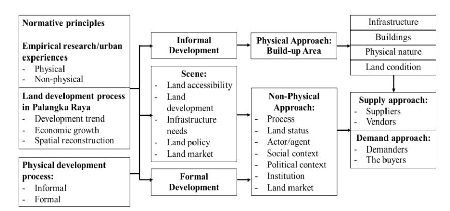
Figure 1. Conceptual framework between formal and informal land development processes. (Source: authors' elaboration)
Study Area
Geographically, Palangka Raya City is located at 113° 30' – 114° 07' East Longitude and 1° 35' – 2° 24' South Latitude, with an administrative area covering five districts, Pahandut, Jekan Raya, Bukit Batu, Sabangau, and Rakumpit Districts. Adminstratively, it consists of thirty sub-districts (see Figure 2). The morphology of the city is generally lowland in the south and hilly in the north. Several significant rivers i.e. cross it: the Kahayan River in the east, the Rungan River in the north to the east, and the Sebangau River in the south (Guntur, Kurniawan, Sutanto, et al., 2023). At the beginning of the city's establishment, a prominent feature was the spread of residential areas on the river banks and in forest environment. Along with the development of the era and development in all city areas, the face of Palangka Raya City has undergone significant changes compared to its beginnings. Based on its function, the city is known for its two faces: rural and urban. The area with an urban function has the following characteristics: the population is concentrated in certain areas, such as the center of government, the center of economic activity, and the center of public services for the community. Meanwhile, rural areas generally lie along watersheds. People do not concentrate on settlements and distribute them unevenly, and their livelihoods remain homogeneous, including farming, planting, and fishing (Guntur & Kurniawan, 2021).
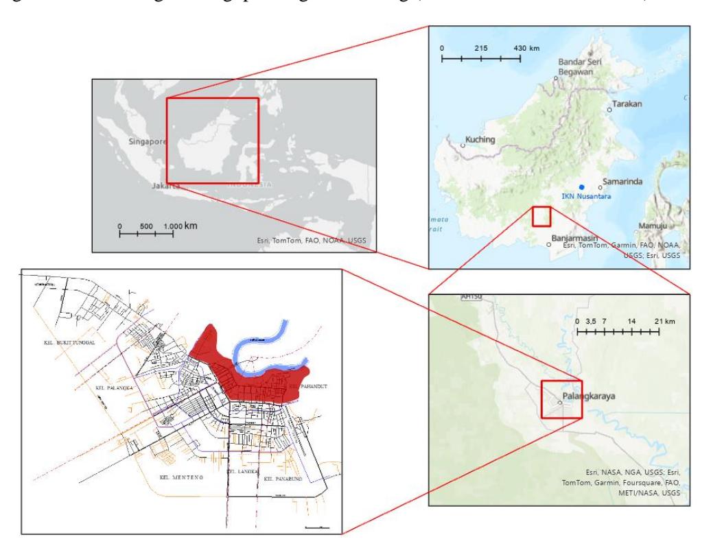
Figure 2. The Old Town area (red color) on an administrative map of Palangka Raya City. (Source: Modified from Palangka Raya Spatial Data of Local Development and Planning Agency, 2022)
Methods
This study identified the factors that lead to land development in the Old Town area, both in terms of the speed of growth and the development of formal and informal land in the area. This study applied a mixed-method approach, i.e., a combination of qualitative and quantitative methods. The quantitative method was used to describe the land development process, especially concerning the mechanisms of the land market (transactions, prices, supply-demand). Meanwhile, the qualitative method explains land development's physical and non-physical factors towards urban land development concepts and theories, especially those related to land development.
The built-up area conditions, land status, land-use patterns, and infrastructure requirements influence these factors. This study's overview of formal and informal land development processes emphasizes land status, land physical conditions, built-up areas, land-market mechanisms, and public and private procedures based on formal and informal land development theories. Then, adjusted for the conditions of land development in the Old Town area, the suitability of the land development review (formal and informal) was the basis for tracing the land development. Researchers used the results of the tracing process as hypotheses for later analysis until they obtained conclusions regarding the land development process in the Old Town area of Palangka Raya City (see Table 1).
Table 1. Identified Variables and Indicators.
| Type | Dimension Parameter | Variable | Abbreviation | Indicator | |
|---|---|---|---|---|---|
| Buildings | Inform_build | Material, condition, size, type, and density | |||
| Informal | Physical | Built-up area | Land condition | Inform_land | Land contour and soil type |
| Trunk | Inform_infra | ||||
| infrastructure | Yes/no | ||||
| Non Physical | Process | Procedures informal | Inform_process | Trust/social legitimation | |
| Land status | Public, Private1a | Inform_landstat | Legal/illegal development2 | ||
| Actors or agents2 | Low-income, middle-income | Inform_act | Kinship, ethnicity, culture (modern/traditional), interest group, religious group | ||
| Social | Urban societal | Inform_soc | Social behavior | ||
| Context2 | non-compliance2 | Disadvantaged group | |||
| Institutions | Public and private | Inform_inst | Local community/ neighborhood (RW, RT) Individual | ||
| Group | |||||
| Supply | Inform_supply | Land availability | |||
| Land market | Inform_demand | ||||
| Demand | Land quantity1b | ||||
| Land price and value | Inform_landprice Availability | ||||
| Speculation | |||||
| Prospect | |||||
| Duration (tenure) | |||||
| Land transaction Inform_transct | Particular price (negotiation) | ||||
| Land use pattern Inform_landuse | RDRTK | ||||
| Physical | Built-up area | Buildings | Form_build | Material, condition, size, type, and density | |
| Land condition | Form_land | Land contour and soil type | |||
| Trunk infrastructure | Form_infra | Extension | |||
| Non physical | Process | Public procedures | Form_process | Planning, permission granted | |
| Land status | Private, public1a | Form_landstat | Legal development | ||
| Actors or agents | High-income and middle income | Form_act | Kinship | ||
| Ethnic group (Guntur & Kurniawan, 2021) Culture (modern/traditional) | |||||
| Interest group (developer, investor, and | |||||
| others) | |||||
| Religious group | |||||
| Formal | Political context3)c | Development process3d | Form_dev | Funding | |
| Project preparation | |||||
| Site preparation | |||||
| Ownership | |||||
| Land policy | Form_land | Incentives/disincentives | |||
| Spatial plan (RTRW) | |||||
| Local regulation | |||||
| Tax | |||||
| Institution | Private and public | Form_inst | Government agency | ||
| Cooperative agency | |||||
| Investors | |||||
| Public Company | |||||
| Land | Supply | Form_supply | Land availability | ||
| market3)a | Demand | Form_demand | Land quantity3)b | ||
| Type | Dimension Parameter | Variable | Abbreviation | Indicator |
|---|---|---|---|---|
| Land transaction | Form_transct | Closed bidding | ||
| (bid/tender) | Open bidding | |||
| Land price and value Land use pattern Formal_landuse | Formal_landprice Using value | |||
| Exchange rate | ||||
| Sale price | ||||
| Detailed spatial plan (RDTRK), | ||||
| accessibility |
Note:
- 1) Angel, Archer, Tanphiphat, & Wagelin (1983): a) Doebele (p. 349): "…Land, particularly urban land, is also uniquely public in that its value is created, to a considerable degree, by the phenomenon of urbanization…" "Land is a profoundly private good because almost all people need the psychological security traditionally associated with owning a house"; b) p. 536.
- 2) Rakodi & Leduka (2003): a) (p. 10): "...the relation between actors or agents in all land delivery system can take a variety of forms: they can be social, involving reciprocity and kinship ties; or political, involving patron-client and class relations, ethnicity, gender, and other; or economic, where market or quasi-market transactions occur"; b) p. 9. 3) Adams (1994): a) p. 17; b) p. 18; c) p. 6; d) p. 47.
The methods used to collect data in this study were: 1) mapping, to analyze and present spatial data. Researchers then evaluated the spatial interactions from the analysis results to identify the relationship between the spatial data and the symptoms of the causes of the relationship; 2) checklist matrix, which contains the necessary data, types of data, year, characteristics of the data; 3) recording in the field, which was done to determine the condition of the data, validate the interview results, and gather data heard directly and from various perspectives; 4) recording data, presenting some of the opinions of researchers, developing frameworks, ideas, hypotheses, and connecting them with some of the data needed. The data used consisted of primary data and secondary data. The primary data was collected to complete incomplete information obtained through the secondary data. We collected it through field surveys, directly observing and recognizing data in the field. Several research tools, such as maps and GPS, supported this activity. The information was collected by conducting interviews with several informants. The informants were selected because they had sufficient information about the research, a good understanding of the field conditions, and a key position in making land development decisions in urban areas. We carried out the interviews purposively to identify data likely to be the same. Meanwhile, the secondary data collected was data obtained through various government offices and community institutions, such as the Municipal Planning Agency, Local Development and Planning Agency (Bappedalitbang), Local Public Works, National Land Agency (BPN), Central Statistical Agency (BPS), Local Social Welfare Service Agency, District Office, and various agencies related to research. The list of required data includes the Spatial Plan (RTRW) of Palangka Raya City, the Detailed Spatial Plan (RDTRK) of Palangka Raya City, land-use maps for 1960-2020, land prices, land taxes, statistical data such as population data, economic data, and infrastructure data.
The analysis technique used was: 1) we grouped some of the collected data, such as the indicators, variables, and parameters in various categories that had been previously identified and selected according to time sequence; 2) to know the distribution of each variable and connect them, we used visual trend analysis of thematic maps arranged based on a time sequence in this study; 3) we analyzed the relationship between informal land development and formal land development by reconstructing each variable category into groups and analyzing them based on thematic maps until we obtained a conclusion; 4) then we elaborated these data with the land development that occurred in the research area based on the concept of planned and unplanned development (van der Linden & Baross, 1990a).
Results and Discussions
Land Development Process in Palangka Raya City
We can classify land in Palangka Raya into two categories based on its utilization: urban land use and rural land use (Spatial Plan of Palangka Raya City 2003-2023). Six sub-districts – Pahandut, Panarung, Langkai, Menteng, Palangka, and Bukit Tunggal – contain land use characterized as urban. Meanwhile, we characterize the land in the remaining sub-districts as rural. The study areas include the Danau Seha area in the Pahandut sub-district, the Flamboyan area in the Langkai subdistrict, and the Mendawai area in the Palangka sub-district. We find land development processes that focus on built-up land in areas with an urban physical appearance, and developers can develop these areas formally, informally, legally, or illegally (van der Linden & Baross, 1990b). In addition, land can also develop because it is affected by a combination of physical factors, such as topography, geology, and non-physical factors (such as economics, administration, land policy formulation, and its adoption), as well as political-economic factors, both on a national and a regional level, and daily politics (Rakodi, 1994, p. 70). An overview of the urban village, which shows these urban characteristics, can be seen in the Old Town area. We studied each part from the perspective of the related factors, parameters, variables, and indicators that shape the development process, both from the perspective of the actors/agents involved, socio-political context, legality, value, and price of land, and its utilization, based on the front built-up zone and the back built-up zone. The front zone is generally a built-up zone close to the trunk infrastructure (roads) and is the main activity center of the area. In contrast, the back zone is away from the trunk infrastructure (roads) and is primarily residential.
Synthesis of Land Development in the Old Town Area
The area includes the Danau Seha, Flamboyan, and Mendawai areas in the Pahandut and Jekan Raya Districts (the result of a division in 2002), with a total area of 768,605 square meters. This old area generally consists of two zones with different functions and designations. People mainly use the front zone for trade, education, and offices. Meanwhile, the back zone is a mixed residential zone for community groups, both low-income and middle-income earners (see Figure 3). Figure 3 shows a part of the Old Town area in Pahandut District called Kampung Pahandut. Formal and informal land development can happen based on the closeness and utilization of existing infrastructure (van der Linden & Baross, 1990a, p. 60). In terms of its location, the area is close to the center of Palangka Raya City. Major roads in this area are Tjilik Riwut Road, Ahmad Yani Road, S. Parman Road, Dr. Murjani Road, and Kalimantan Road, which provide the main routes through Palangka Raya City. Based on the analysis, this study showed that the area's proximity to the city center and its location along the main roads are critical for land development.
1. Physical Factors
a. Natural physical and soil conditions
In general, physical factors are among the factors that cause land development in urban areas, both formal and informal. Naturally, the land in the old area of the city is still part of the banks of the Kahayan River and has a slope of 3%. The soil formed is the result of river water eruption. Hard soil exists at 3 to 4 meters from the ground surface. Meanwhile, the groundwater is 1 to 1.5 meters from the surface and is fresh water. Another part of the area is still swamp and overgrown with a forest close to the river mouth that is home to proboscis monkeys. Based on the condition of the soil, the alluvial eruption soil comes from river sand deposits that have collected on the edge of hard soil. Therefore, the soil fertility level in this area is quite good because it contains native soil with a thickness of 2 meters, and the sand and river silt mix with sediment, resulting in regosol, organosol, and podsol soil types. However, frequent flooding makes growing production plants difficult in this area. 3 Thus, when viewed from the physical condition of the land, this area can still be developed for housing, although a particular construction material has to be used (wood4 ).
b. Building condition
Buildings in urban areas are clustered around markets, riverbanks, and roads and form various plots of land (Knox & Pinch, 2014). When viewed from its formation, the Old Town area is mostly behind activity centers, such as the Kahayan market (traditional market), the Payang Sari market (traditional and modern markets), and the Flamboyan Trade Center. This area's most distinctive feature is the high residential density level behind the trading zone. Overall, the buildings in the old area are dominated by semi-permanent buildings made of wood, with a density from 140 units/hectare to 441 units/hectare. The average building size is 30 square meters, with land sizes ranging from 200 to 300 square meters. One-story buildings have an average distance between them ranging from no distance to 3 meters.
Overall, the available infrastructure in the Old Town area is simple and needs upgrading. Builders construct most path streets from wood or slats, with a 1 to 1.5-meter width. Therefore, this area is impassable by four-wheeled vehicles, so it is tough to access and reach if a fire or other disaster occurs. As a result, it is not uncommon to have fires that destroy entire areas without being anticipated. Even though, in general, other infrastructure networks, such as electricity, clean water, and telecommunications service networks, serve this area, the arrangement of these networks implemented in the field still needs to be improved and better organized.
2. Non-physical Factors
a. Land acquisition process
Acquisition of land in the old area generally takes place informally. Meanwhile, the government acquires land designated as development area through public procedures. This was done, for example, in 1986 for the Mendawai area; the government designated this area for relocation due to fires in the Flamboyan and Lake Seha areas. The process was as follows: land cultivators cultivated land without permission and then relinquished their land rights to the following land users. The following land user could not apply for land certification by the urban village head (lurah) – officials could only forward the application to the sub-district. Most of the occupants of the area up to this stage had relinquished their rights over the land to a second land user and so on. Speculation like this often occurs in this area of the old town.5 It happens because, at this stage, the costs incurred to manage land in this location are still low. Meanwhile, the price of land will become much higher than the cost of managing the land if the land is sold and has legal status. Figure 4 and Figure 5 provide an overview of this process. Figure 4 shows the actors or agents involved in the land development process (Adams, 1994, p. 45; Rakodi & Leduka, 2003, p. 10). It explains the relationship between government agencies and the community and the relationship
3 Interview with a representative of urban residents, August 2022.
4 Field survey and interview, August 2022. The most commonly used building material is wood because it is considered more efficient and economically effective (interview with an urban resident).
5 Interview with a staff member of the National Land Agency of Palangka Raya City, August 2022.
between the institutions they form, both formal and informal (North, 1989), in developing land in the old town area in general.
Figure 3. Kampung Pahandut along the Kahayan River, Palangka Raya City. (Source: field observation, 2023; modified from data of the Computational Laboratory, Department of Architecture, Faculty of Engineering, University of Palangka Raya, 2022, with permission)
The first stage of developing land in this area begins when the original land supplier exercises land tenure on state land not for urban use or waqf land. In various transfer forms, they relinquish their land rights to subsequent land demanders (community groups or individuals) (Needham & De Kam, 2004, p. 2061). They can hand over the land to their family as an inheritance; it can also be that the land is given as a perpetrator plot6 and rented out and sold, meaning that cultivators still carry out the land development process. In this stage, the community or individuals gain direct access to land development (occupation, construction, and building development). The second stage involves the government, in this case, the municipal government of Palangka Raya, 6 Perpetrator plots are land given by the husband to the wife in a Dayak traditional marriage.
due to social and political pressures (Angel et al., 1983, p. 3; Knox & Pinch, 2014, p. 206; Rakodi & Leduka, 2003, p. 3). It begins with the government paying attention to the built environment and assisting in developing Infrastructure such as local roads, electricity networks, telephones, and clean water. With the support of the municipal government, this triggers the development of the land in the area around the built infrastructure (van der Linden & Baross, 1990a, p. 60). Generally, at this stage, the government involves the private sector (local contractors) in implementing infrastructure development projects, or sometimes, because the projects are small, the government implements them by itself (self-management).
Figure 4 is a land development process that departs from actors/agents that tend to be more informal. The land is owned and dominated by the community, which, concerning institutions, is more socio-economic (Nabli & Nugent, 1989, p. 1334). Meanwhile, the government's concern for the community is considered political-economic (Rakodi, 1994). Land development is done only by providing limited infrastructure. Thus, the government generally plays a minor role in dealing with these areas. In other words, in the land development process that occurs in these areas, the two actors/agents, both the government and the land user community, and the institutions they have developed seem to be more dominant in acquiring land (Nabli & Nugent, 1989, p. 1335; North, 1990, p. 6). This means that, on the one hand, the community is trying to survive and continue to develop. On the other hand, the government needs to pay more attention to dealing with problems that arise, allowing the area to develop within the framework it has outlined, for example, granting land-use rights for 15 years.
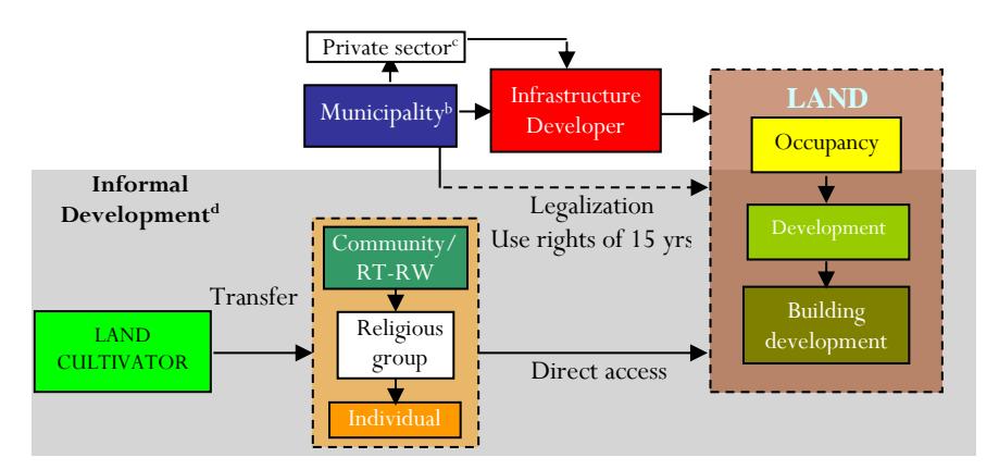
Notes:
Actors/agents are the capacities of community groups, individuals and groups (low-income and middle-income), and institutions involved in the area, both from the public and private sectors, to make choices and actions that affect their destiny (Knox & Pinch, 2014).
- a) Cultivators are community groups or individuals who have or have not obtained permission from the municipality to cultivate land in the area (usually free of charge).
- b) PEMKO is the municipal government that allows a person or community group to cultivate the land.
- c) The private sector is usually a local contractor.
- d) Informal development is developing land without going through public and administrative procedures that apply to official areas (Rakodi & Leduka, 2003, p. 9).
Figure 4. Actors/agents based land development scheme for the Old Town area. (Source: Analysis result, 2023)
In the second scheme (see Figure 5), the land development process in these old areas was more of an event or relationship within the structures/institutions formed. The first stage was the cultivation of the land. We investigated this on land developers who had not used land for urban functions before 1960 and on land who began using land for urban functions after 1960. In the second stage, the land in this area was developed and entered into the scope of urban or public
planning, especially in the 1960s. 7 This is because the land in this area was infrastructure development utilized, especially river ports, and for land consolidation to relocate people affected by fires in 1986, particularly in the Mendawai area. 8 The third stage was the formation of community plans for developing the area, starting with places of worship for dominant religious groups. Then, the community developed local pathways by utilizing the land they controlled communally. It was one of the solutions to the access problem they faced (Rakodi & Leduka, 2003, p. 11) to anticipate the government's involvement, which only provided the trunk infrastructure. Most of the funding came from local communities themselves. 9 In the event scheme, the description of the land development process in these areas tends to be dominated by activities or plans developed by the government to build infrastructure that does support a residential function but is more of an access development for economic activities, such as the development of a port in the 1960s. However, the government implemented the plan without following strict rules. Consequently, the community has already implemented its plans in these areas. As a result, the region developed on its own without solid government support.
b. Land Status
We can classify land in these Old Town areas into state-owned and community-owned. Stateowned land is part of the land that has not yet developed. People who live around the area have unofficially (illegally) divided the land into plots. Landlords now illegally control this land. 10
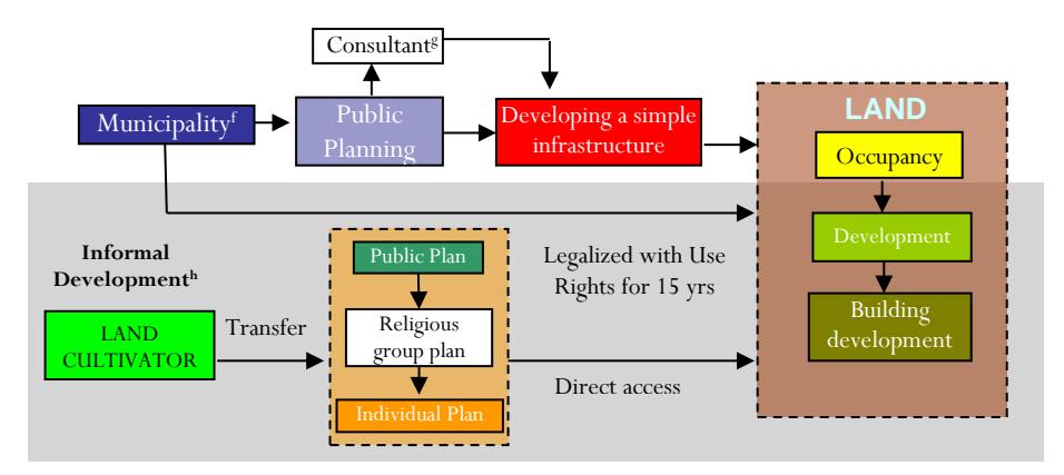
Notes:
Events are activities carried out by actors or agents to develop land in the Old Town area.
- a) In 1985, the community had already occupied all the existing land, and there were no more land cultivators in Mendawai (BPN, 2005).
- b) In 1986, there was a big fire in the Flamboyan area, so there was a relocation project to the Mendawai Area.
- c) In 2004, a fire-related relocation project in S. Parman Bawah Road was completed in 2003 (BPN of Palangka Raya City, 2005).
- d) Permits granted for land under 1 ha are sufficient to reach the Local City Planning Agency (DISTAKO). In comparison, permits for locations that are more than 1 ha for non-private residential functions, such as housing, agriculture, plantations, and others, are given by the municipal government through a meeting chaired by the Mayor consisting of the Government Section, Local Development and Planning Agency (Bappeda), National Land Agency (BPN), DISTAKO, and Local Revenues Agency (Dispenda).
Figure 5. Events based land development scheme for the Old Town area. (Source: Analysis result, 2023)
7 Detailed Spatial Plan of Palangka Raya City, 1984, urban land use.
8 BPN of Palangka Raya City, 1991, urban land use.
9 Interview with a land owner, August 2022.
10 Interview, August 2022.
c. Actors/agents
Government, private, and community development agents play inseparable roles in urban land development. The relationships between these agents shape this development process (Rakodi & Leduka, 2003, p. 10). In these Old Town areas, land development actors and agents tend to be people who generally find it difficult to socialize in an urban area or are socially non-compliant (Rakodi & Leduka, 2003, p. 18). Other groups that also play an essential role in land development are interest groups and religious groups. Both groups play the same role; the first group wants to live in the area because of convenience and proximity to the city. The second group exists because of having the same religious perspective, such as worshiping in a mosque or a church. Most of the area's residents are low-income, while some are middle-income. 11 Meanwhile, the government tends to act as a ruler with the power to do anything. In this regard, the government intervened in the area only according to the wishes of the government itself (Giddens, 1986; Knox & Pinch, 2014), as was the case with the political decision to designate the area for relocation to the Mendawai area and the George Obos area because of the Flamboyan fires in 1986, 1998 and 2003.
d. Context of Social, Political, and Institutions
Land development in an area is also heavily influenced by various involvements and interactions of individuals, institutions (both community institutions and government institutions), and political decisions that occur in an area (Rakodi & Leduka, 2003, p. 10). In these areas, most of the land is inhabited by social groups that generally have difficulty socializing (societal noncompliance) and often try to live in their ways, even though they are marginalized by formal institutions (Rakodi & Leduka, 2003, p. 18). Meanwhile, public and private institutions are viewed on the one hand as prisons, schools, or mental hospitals, shaping society's identity. Thus, there are shifts and interactions in community groups in these areas that shape their identity. Meanwhile, identity is an element that will enhance people's perspective of themselves (interpellation – see Knox & Pinch, 2014). These identities can be seen in social groups formed in these areas, both formal and informal. Formal groups can create rules that exist in the environment. Meanwhile, informal groups form informal agreements and regulations recognized socially in the community even though they were created informally (North, 1990; Rakodi & Leduka, 2003).
When traced based on the identity of their work, in general, the residents of these areas are mostly community members with permanent jobs in the city center, such as traders and even civil servants (PNS). 12 However, most of the social behavior that occurs in these areas is difficult to understand, such as the habit of living crammed into one location, looking for cheap housing in the city center, and if necessary, free of rent and without spending money but still expecting to be able to occupy the land in peace. Culturally, three things shape this perspective. The first is the values held by the community. Second, they follow certain norms. Third, there are objects that they depend on, such as transportation systems, buildings, and urban facilities (Giddens, 1986; Knox & Pinch, 2014).
Meanwhile, when viewed from government policies in terms of land use, it is seen that these areas do not support one another. On the one hand, they tend to be more economically oriented, while on the other, they tend to be more conservation-oriented. As a result, people who generally belong to social groups whose nature and character are still adjusting to the urban context become confused. Sometimes, these groups make their own rules and norms (North, 1990; Rakodi &
11 Field survey, 2023.
12 Field observation, 2023; a PNS is a civil servant, which could be a teacher or local government employee.
Leduka, 2003, p. 19), actively creating opportunities to solve their problems (Rakodi & Leduka, 2003, p. 11). It means that the government tends to create more opportunities for illegal areas to be formed in these areas.
The formation of informal settlements (irregular settlements) or, in this sense, groups of people who cannot be urbanists (societal non-compliance) are established in these old town areas. It is more than just a protest against the applicable law; it results from government rules that contradict each other or are unrelated (Rakodi, 1994). However, the emergence of urban communities living in illegal areas does not mean conflicts in the social system caused by legal rules set by the government in obtaining these rights. However, more than that, they are formed because of a parallel relationship between legal and illegal, significantly related to a city's or region's sociopolitical and economic influences (Rakodi & Leduka, 2003). Other events related to the formation of settlements and land tenure in the Old Town areas occurred more frequently due to protests by organized social groups or urban social movements against policies set by the government, which tended to be unilateral (Rakodi & Leduka, 2003, p. 20). For example, the case of the formation of illegal settlements in the Flamboyan area was triggered by the actions of some members of the local council13 who supported the return of the original (illegal) occupants in this area after a big fire that occurred in Flamboyan Bawah, which reached parts of the area in 1997. Previously, the local municipal government had designated the George Obos area for relocation due to fires, which occurred at that time by providing low-cost housing developments14 for the former Flamboyan residents. However, until now, the area is partially inhabited but mostly only occupied by land and buildings. 15 It shows that the conditions for land development in urban areas are more influenced by political decisions, the interactions between individuals and institutions formed, and the social groups within them (Rakodi & Leduka, 2003).
e. Land Market
Land can develop in an area due to the process of transferring land rights through market mechanisms (Needham & De Kam, 2004, p. 2076). Meanwhile, the market is a vehicle for sellers and buyers to meet. Therefore, the land market can be viewed from the perspective of land buyers and sellers, both from the public and private sectors (Carmona et al., 2003, p. 49). In observing these market considerations, the factors reviewed include the market mechanism and land-use pattern, accessibility, supply and demand, land prices and values, and transactions carried out by actors/agents involved in the market mechanism (Adams, 1994, p. 17). Regarding the land-use pattern, there are differences in utilization between the front and back areas. The front area is used for trade, education, and government functions, usually on the main trajectory. In contrast, the back area is mainly used for residential functions. In terms of accessibility, the availability of land and high growth in the front area are the main drivers for these areas to develop, and in general, the accessibility options formed in these areas tend to lead to main routes and infrastructure in the front area.
Built-up areas have been markedly increased based on supply and demand. For example, the Mendawai area increased from 198,000 square meters in 1995 to 234,767.35 square meters in 2005, or an increase of 25,978 square meters (15%). In the Flamboyan Area, there was an increase from 20,880 square meters in 1970 to 114,144 square meters in 2005, or an increase of 93,264 square meters (547%), and in the Danau Seha area from 135,610 square meters in 1970 to 327,832 square meters in 2005, or an increase of 192,222 square meters (142%); this increase mainly
13 City Council of People's Representatives (DPRD), 2001.
14 Bank policy on resettlement (1993).
15 Interview with local staff members of municipal agencies, August 2022.
covers zones in the back area, which are far from the trunk infrastructure that has been built by the local government. 16 Most of the transactions carried out by people in these areas to acquire land are informal because the process is only based on trust, market will, or market considerations, with prices based on negotiations between the two parties (Giddens, 1986; Rakodi & Leduka, 2003, p. 14), depending on environmental conditions, the condition of the land or buildings that stand on it, or the information they receive at that time. Relinquishing land rights is done through simple and fast sale and purchase transactions (purchase receipts); sometimes, these transactions are carried out without clear witnesses (Needham & De Kam, 2004, p. 2061). Groups of people who live in urban communities will then take care of the legality of their land, whereas in the case of those who do not, the land will change hands again to the next owner (North, 1990).
Based on the value and price of land, this area can be classified into two land price reviews: the formal land price determined based on the NJOP (Tax Object Selling Value) and the land price based on (informal) market prices. Determining the price and value of land according to the Regulation of the Mayor of Palangka Raya Number 2 of 2021 concerning the Imposition of Land and Building Tax in the Rural Sector and Urban Region in Palangka Raya is done based on market data, cost, and income capitalization approaches. Meanwhile, land prices and values based on market prices are land prices determined in buying and selling transactions between suppliers and demanders, where land prices depend on information obtained by demanders and information provided by suppliers, or more physically looking at the environment, buildings, land size, soil condition, the proximity of the land to trunk Infrastructure (usually roads and power grids), or main activity centers in the zone or the area as a whole (Giddens, 1986; Rakodi & Leduka, 2003). For example, land in a zone that can only be passed by two-wheeled vehicles or is located on a small gravel road is cheaper. 17
An overview of the development of land prices in the Old Town area can be seen based on the lowest price in the back area and the highest price in the front area in 1986, and the highest price in the front zone and the lowest price in the back area in 2005 for each area and 2021. Land value data shows that the difference between the NJOP and market prices was significant between the front and back zones in 1986, 2005, and 2021. Even for the front zone, land values and market prices in 1986 (31,000 IDR/square meter and 29,760 IDR/sqm, respectively) were still higher than land values and market prices in the back zone in 2005 (14,000 IDR/sqm and 13,440 IDR/sqm, respectively), but it increased to 2,013,000 IDR/sqm in 2021. This means that the increase in land prices and values in the front zone used for trade (commercial) functions was faster than the growth rate of land prices and values in the back zone used for residential functions. The trend of increasing land prices in these old areas from 1986 to 2021, both in the front zone and the back zone, showed an increase in value, which means that there was an increase/growth in land prices in the area in line with the increase in the built-up area in the area. Many of these high land prices are seen in the front zone of the area, which is the trade area zone. Meanwhile, meager land prices occur primarily in areas that still need to be built up and in residential areas far from the trunk infrastructure.
Conclusion
Land development in Palangka Raya City happens both formally and informally based on the proximity and utilization of existing Infrastructure. In general, physical factors cause land development in formal and informal urban areas, with the area's condition on the river banks and unfavorable soil conditions for carrying out permanent building construction, making it
16 BPN data of Palangka Raya City and field survey, 2023.
17 Interview with an urban resident, Agustus 2022.
challenging to develop land, but what develops are semi-permanent buildings that are light in construction. With a high density of buildings behind the main trading center of the city, the overall available infrastructure in the old area of the town is still simple and needs to be upgraded. Land acquisition in the Old Town area generally occurs informally, especially the land development process that departs from actors/agents. The community dominates land development, and the institutions they form reveal more of a socio-economic motivation. In contrast, the government's connection with the community is seen as more politic-economic.
Formal land development happens only when limited infrastructure is provided. Thus, the government has generally played a moderate role in dealing with the area. In other words, in the land development process in the Old Town area, the two actors/agents involved, i.e., the government and the land user community and the institutions they have developed, were found to be more dominant in acquiring land. This means that, on the one hand, the community is trying to survive and continue to grow, while the government, on the other hand, is not paying enough attention to dealing with problems that arise in the area, allowing the area to develop by itself within the framework outlined by the government, for example, land-use rights for fifteen years. While, apart from events or activities, the land development process in the Old Town area tended to be dominated by activities or plans developed by the government, infrastructure was not built for residential functions but to create economic access, such as the construction of the port in the 1960s. However, the implementation was carried out later without being accompanied by strict regulations that followed it. Thus, community plans had already been implemented in the area. As a result, the region developed without solid government support. Land in this area can be classified into two land statuses: state-owned and community-owned. State-owned land is part of an area's land that has yet to be developed, but unofficially (illegally), the land in this area has been divided into plots by the people living around the area, meaning that there are landlords who illegally control the land. 18
Land development in urban areas cannot be separated from government, private, and community development agents, nor can the relationship between them be separated. In these old areas, land development actors and agents are community groups that generally have difficulty socializing in an urban area or are socially non-compliant. Meanwhile, the government tends to act as a ruler with the power to do anything. In this regard, the government intervened in the area only according to the wishes of the government itself, as was the case with the political decision to designate the Flamboyan area for relocation to the Mendawai area and the George Obos area because of fires in 1986, 1998, and 2003. Therefore, land that can develop in an area is also heavily influenced by various involvements and interactions of individuals, institutions, community institutions, government institutions, and political decisions that occur in that area.
In addition to the social factors mentioned above, land development is also influenced by market factors; in other words, more land can grow in an area due to transferring land rights through market mechanisms. The differences in land prices and values based on market prices and NJOP prices show that the prices and land values in the front zone were much higher than in the back zone from 1986 to 2005. Even for the front zone, land prices and values in 1986 were still higher than in the back zone in 2005. It means that the speed of growth in the price and value of land in the front zone used for trade (commercial) functions was faster than the speed of growth in the price and value of land in the back zone, which was used for residential purposes. Concerning the trend of increasing land prices in these old areas from 1986 to 2005, both the front and back zones showed an increase in value, which means there was an increase in land prices in the area in line with the increase in built-up area. Many of these high land prices are seen in the front zone of the
18 Interview, 23 August 2022.
area, which is the trade area zone. Meanwhile, meager land prices in these areas are primarily seen in areas that still need to be built up and in residential area zones far from the trunk infrastructure. It means that the old areas have low land prices and values and are located around areas with very high land prices; this leads to informal residential areas being formed in these areas.
The local urban community should be able to adjust to life in an urban area. They can follow the rules of life in a metropolitan area so that land development can gradually become formal. The government continues to support formal and informal residential developers in developing land, mainly by providing well-organized infrastructure such as roads, electricity, telephone, and clean water. It is better if the policies and political decisions the government issues are clear; these interventions should involve other actors, such as the private sector and local communities. The private sector should develop land for already well-organized areas and actively engage in developing regions that still need better management. Formal institutions need to be formed to organize and regulate land development in physically developed areas that need better development. Informal institutions need to be formed to connect the wishes and desires of the community so that they can be adequately implemented, especially with formal institutions, so that they can direct the community towards formal land development.
Acknowledgments
The authors thank the Department of Architecture, PPIIG-eco vernacular urbanism laboratory, and the Faculty of Engineering, University of Palangka Raya, for supporting this research.