
Introduction
Since the second half of the last century, the urbanization process in many regions of developing countries has been experiencing a significant transformation, resulting in a higher proportion of the urban population in the regions. Population growth in urban areas has been the main driver of this process (Henderson, 2002; Cohen, 2004; McGranahan et al., 2014; Jedwab et al., 2017; Mahtta et al., 2022). Urbanization and city growth have been closely related over time. However, not all urbanization processes take place in cities, with permanent population inmigration to the cities, as some of them occur outside of cities, with the densification of population activities and built-up areas, which can bring an economic transition of the areas
involved (Randolph and Storper, 2023). Not only do new cities form but others expand and develop into metropolitan areas with subcenters in their peripheries during the urbanization process (Berliant et al., 2007). Urban population growth plays a crucial role in this process (Jones, 2002). Pradhan (2004) explains that the growth of urban population can be influenced by three factors: natural increase, migration, and the reclassification of new urban areas. The first two factors are directly influenced by demographic events, while the third factor is due to spatial events associated with demographic and urbanization processes, which involve changes in the classification of certain areas from non-urban to urban areas, resulting in implications for the populations residing in these new urban areas, as they must be reclassified as urban populations. In the reclassification process, the expansion of urban areas into surrounding non-urban areas is partially a consequence of the spatial events along with the creation of new urban areas in previously non-urban areas.
In terms of demographic features, Cohen (2004) argues that urbanization in developing countries differs from that in Europe and the USA in its unprecedented scale and rate. In developing countries, the scale of urbanization, or the absolute number of urban populations involved in the process, is much larger than that in developed countries, while the rate of urbanization is also much faster. Therefore, understanding the urbanization process in developing countries is an important undertaking. Furthermore, Jain (2018) has argues that contemporary urbanization in developing countries remains a major challenge, considering the significant variations involved and the challenges within regions (Cohen, 2004). Responding effectively to the challenges of urbanization has become a crucial task (Cohen, 2006; Mezgebo and Porter, 2020). In understanding these challenges, Wijaya and Buchori (2022) emphasize the importance of understanding the growth of urban populations.
Even though urban growth still attracts the attention of many urban scholars today, the focus remains mainly on the development and growth of large and major cities (Jain & Korzhenevych, 2020). Few studies have focused on small towns and cities (Connolly, 2008), although the biggest socio-spatial transformations occur in small towns and cities rather than in large ones (Bai et al., 2017). In addition, the majority of urban population resides in small towns and cities with fewer than 300,000 inhabitants each (UN, 2019). Using the experiences in China, Li (2020) classifies growing towns in the urbanization process into two categories: towns that grow in the peripheries or surrounding areas of cities and form polycentric metropolitan areas, and towns that are classified as generalized dispersion ones or towns that grow without direct influence from any bordering cities.
As the most densely populated island in the world, Java has indeed experienced rapid urbanization and urban expansion beyond city limits, both in large cities like Jakarta, Bandung, Surabaya, and Semarang as well as in smaller cities like Malang, Surakarta, Yogyakarta, Cirebon, Tegal, and Pekalongan (Mardiansjah & Rahayu, 2019). Many of these areas have become urbanized areas with more than one million urban residents. However, the traits of urbanization on the island also occur in much smaller urban areas outside of the cities, whether or not they are located in the vicinity of any cities. There is a dearth of research into urbanization focusing on small cities in Indonesia, especially when it comes to the urbanization process that takes place outside of cities. Mardiansjah et al. (2021a) argue that future challenges of urbanization in Indonesia will also come from smaller urban areas with a population of 100,000 to 300,000 inhabitants, especially those in administrative areas of regencies. They classify urbanized regencies into two groups: autonomous city-bordering regencies and noncity-bordering regencies. These groups mirror Li's previously-mentioned grouping of growing towns.
City and town development through the urbanization process on Java Island is related to the local subdivision enforced on the island as well as in other places in Indonesia. This local subdivision was influenced by the designation of cities as urban areas during the Dutch East Indies colonial period (De Angelino, 1931). De Angelino (1931) states that the formation of urban areas in the Dutch East Indies Colonial era was influenced by the segregation of power at that time, as the colonial government needed to manage the areas autonomously, separated from the existence of local rulers. Therefore, the designation of towns (or cities) depended on the interests of the colonial government in managing its colonies (or areas), especially, at first, in the area of judicial power, which later expanded to other interests, such as social, economic, military, and other interests. Some areas with the presence of European and other foreign citizens were designated as towns with autonomous management. In this system, as explained by De Angelino (1931), the towns were regulated and managed by the Dutch colonial rulers, while the rest were regulated by regents as local rulers or leaders in the Javanese administration, who also became the most prominent persons in their territories (regencies). In the era of independence, these towns and regencies were designated by the Constitution to be of the second level of regional government in the Indonesian system. As both of them were subordinated to the first-level areas called provinces, cities and regencies shared the same level as autonomous regions, also being considered local areas. Regencies were perceived as nonurban areas, while cities were considered urban areas. With some changes in nomenclature, the number of cities and regencies in Indonesia also changed across multiple eras. Today, cities are legally called daerah kota (cities) or just kota in daily conversation, and regencies are legally called daerah kabupaten or just kabupaten. With their large area—much larger than that of a city—and being made up mostly of rural areas, the perception of regencies as non-urban areas persists until now, even though no regulation specifies regencies as a specialized territorial division for non-urban areas (see also Mardiansjah et al. (2021a)).
Today, numerous regencies can be considered urbanized regencies, with more than half of their population falling within the classification of residing in urban areas within their territories. Mardiansjah et al. (2021) argue that the urbanization process in Indonesia is mostly driven by the growth of urban populations that are concentrated in urban areas within the territories of regencies. In other words, the urbanization process occurs outside of cities. In this paper, these within-regency urban areas are referred to as 'towns' to distinguish them from the classification of formal autonomous urban areas called cities. Most towns are formed by the agglomeration of urbanized villages. The growth of towns in regencies bordering cities is often directly influenced by the expansion of urban activities from these bordering cities, while the growth of towns in the non-city-bordering regencies is more independent and less related to the urban growth of any city. The urbanization process outside of cities in Indonesia remains largely undocumented, however. Therefore, with the aim of raising awareness and understanding of the urbanization process within regencies, this paper describes and interprets the socio-spatial aspects of in-regency urbanization. Kudus Regency was used as a case study, which has a different pattern of within-regency urbanization compared to other regencies, most of which have scattered small towns and extensive spatial pattern (see Mardiansjah, 2020). This paper is expected to contribute to our understanding of the increasingly important process of urbanization outside of cities today.
Kudus Regency is one of the urbanized regencies on Java Island, with an urbanization level of over 80% in 2020 (Mardiansjah et al., 2021a). It is the smallest regency in Central Java by area, housing nine kecamatan or districts in total. Its capital, Kecamatan Kota Kudus, or Kudus Town is located approximately 60 km east of Semarang City, the capital of Central Java Province, which has developed into a medium-sized metropolitan area with an urban population of 1.7 million, separated by Demak Regency. Kudus Town itself played an important role in Javanese history, beginning with the construction of the Kudus Mosque in 1548 as the center for Islamic teaching in Java (Suharso, 2017). However, its growth has been slower compared to that of Semarang City, which was developed by the Dutch East India Company as a port city in the mid-17th century.
Theoretical Framework on Regional Urbanization and Small-Town Development
In the initial focus on urban studies and urbanization, Popenoe (1965) describes urban areas as physical clusters of human settlements that function as economic entities, such as labor market areas. As for urbanization, he defines it as the aggregation of individuals into relatively dense and heterogeneous settlements, formed by the confluence of people and activities, resulting in a spatial entity manifesting the urban process (Popenoe, 1965: 30). Meanwhile, Friedmann (1965) contended that urbanization is a process or evolution of a spatial settlement system, which simultaneously entails the evolution of its socio-cultural fabric. This socio-cultural evolution is evidenced by the progression of the dominant socio-cultural system within society, which subsequently develops urban social structures and lifestyles, often leading to the modification and transformation of these structures into new configurations (Friedmann, 1966).
Henderson (2003) asserts that the urbanization process is closely linked to economic growth. This process, which reinforces urban concentration, affects productivity and promotes economic growth through sectoral shifts within the economy towards modernity, thereby enabling the strengthening the roles of urban concentrations in the region (see also J. V. Henderson & Wang, 2005). Bertinelli and Black (2004) further explain that urbanization influences economic growth by enhancing urban concentrations, providing educational and employment services that facilitate the adoption of new ideas and technologies, reducing production and transaction costs, and improving specialization within the concentrated population and enterprises. Consequently, numerous studies (see Friedmann, 2006; Henderson, 2003) as well as global institutions like the World Bank have suggested that urbanization is related to economic growth and that its synergy with industrialization serves as a pathway for the development of countries and regions. They advocate for policies to manage urbanization with the aim of promoting economic growth, while mitigating the spillover effects of urbanization and urban development on rural and non-urban areas (Ha Minh Nguyen & Nguyen, 2016).
Urbanization, regarded as a transformative process toward modernization, has emerged as a modern transformative phenomenon since the second half of the last century (Cohen, 2004; Handayani, 2013; Setyono et al., 2016; Jain & Korzhenevych, 2022). This multidimensional socioeconomic transformation from rural to urban communities also impacts the physical and spatial conditions of regions (Mardiansjah et al., 2021a). From a narrow perspective, physical features such as land use and other environmental aspects, including the city's internal structure, can be altered due to the concentration of the population and activities in specific areas (Liu, 2018; Septiarani et al., 2019; Bhagat & Mohanty, 2009; Mardiansjah et al., 2018). From a broader perspective, changes also occur in the population structure, the regional economic structure, the environmental conditions, and the regional structure (Handayani, 2013; Mitra & Kumar, 2015; Deng et al., 2021; Bounoua et al., 2018). Therefore, urbanization, driven by factors, including changes in population, land use, and population activities, is a crucial process in the development of cities and regions (Liu, 2018).
Later, urbanization studies have increasingly focused on the process of urbanization beyond traditional city boundaries. Looking at Asia, McGee (1991) describes the urban transition process beyond previous urban areas, resulting in the formation of desakota regions outside peri-urban regions, particularly along corridors between large cities. These regions are characterized by densely populated rural areas engaged in wet-rice agriculture, where urban and agricultural activities are intensively mixed, stimulating the growth of urban areas, including urban centers in the peripheries (McGee, 1991). The core of the city, along with growing urban regions and peripheral centers, can be viewed as a metropolitan area, as it constitutes urban elements within an urban region (McGee & Robinson, 1995; see also Natalia & Heinrichs, 2019). McGee (1991) suggests that the development of metropolitan regions may be concluded with a process he calls regional urbanization. Soja (2011) argues that the formation of multiple urban centers around a previous urban core has become the dominant spatial model in contemporary urbanization. The development of surrounding subcenters, where traditional monocentric structures are transformed into a polycentric urban structure, indicates the spatial decentralization of economic activities into the peripheries. This shows that the core area is no longer the sole concentration of activities and jobs, which are now dispersed into surrounding urban concentrations (Natalia & Heinrichs, 2019; Wang et al., 2023).
Li (2020) argues that there is no consensus on the characteristics of the emerging urban spatial structure, as there are two different views in the analysis of urban spatial structure: the nucleated dispersion view and the generalized dispersion view. The nucleated dispersion view holds that the development of subcenters is stimulated by the dispersion of jobs and population beyond the traditional city core. Such development facilitates the emergence of polycentric metropolises with edge cities surrounding the core. On the other hand, the generalized dispersion view argues that dispersion does not necessarily form polycentricity but rather just a generalized dispersion pattern (Li, 2020).
Cladera et al. (2009) describe the common growth and development path of subcenters as involving three stages: residential decentralization, employment concentration, and the development of the subcenter as a structural element of the urban sub-system within the metropolitan configuration. Regarding the evolution from mono-centricity to polycentricity, as conveyed by Zhou et al. (2024), many empirical studies have shown that the evolution of the spatial structure begins with the deurbanization of a large population concentrated in the city center, dispersing to areas with lower population densities. They contend that the development of large-scale suburban housing and service facilities transfers employment to lower-density suburban and peripheral areas, and the growth of road networks and communication technologies has facilitated economies of scale in these areas, transforming them into subcenters. This process alleviates agglomeration diseconomies associated with monocentric agglomeration and leads to the formation of a polycentric urban structure.
Using his concept of regional urbanization process, Soja (2011) argues that the extended urbanization process of urban growth and urbanization has created a more heterogenous urban region concept and ended the traditional bordered urban concept. A broader urban concept has been formulated based on the combination of spatial, social, and economic dynamics in the urban network within regions. The dynamics of the combination have strengthened interconnectedness among regions through the intertwining urban network. These bring analyses on urbanization into a new urban age that combines and blends urban and regional activities in the urbanization process.
In the regional urbanization context, Jain and Korzhenevych (2022) argue that the urbanization process and the growth of social and economic activities today are not solely concentrated within cities or in urban space but also in non-city space or outside of cities. In India, this is shown by the formation of census towns. Based on the census of India, Jain (2018) defines census towns as urban areas in rural regions that have more than 5,000 inhabitants, with a population density of more than 400 inhabitants per km2 and more than 75% of males working on non-agriculture activities. Jain and Korzhenevych (2022) further argue that the development of census towns has become more significant in the urbanization process in India, as they contribute more than 30% to the urban growth in the country. Mitra and Kumar (2015) argue that the formation of census towns has also given rise to new cities in non-urban regions, as the result of the development of some particular rural areas, even though they have not yet been established as urban areas with a clearer status. Based on the experiences in Fujian Province in China, Zhu (2000) explains a similar process that he calls in-situ urbanization as an urbanization process that takes place in rural areas without significant influence from permanent inmigration. The process is made possible by the existence of densely populated rural areas, followed by the growth of urban areas as well as rural enterprises that bring about socioeconomic transformation out of agricultural activities (Zhu, 2000). Based on observations in India, Randolph and Storper (2023) describe in-situ urbanization as urban growth that is driven by increasing population density and socio-economic transformation away from cities to agricultural activities in the urbanization process. In-situ urbanization also refers to the town development process in previously rural areas, encouraged by development policies that promote economic growth and social as well as population transformation, with the majority of the population remaining in these areas (Zhu, 2017; Li et al., 2022; Zhang and Zhou, 2022; Shen et al., 2024).
Materials and Methods
Kudus Regency: The case of a non-adjacent urbanized regency in the periphery of a medium-sized metropolis on Java Island
Kudus Regency, located approximately 60 km away from the core of a medium-sized metropolitan area in Central Java, can be considered a distinctive region due to its high population density and industrial activities as the primary economic base, which bring it into a high urbanization level. According to the 1971 National Population Census, the regency had a population of 449,432 and a population density exceeding 1,000 inhabitants per km2 at that time. With 87,767 urban dwellers as its urban population, its urbanization level was 19.53%. The population density of the regency started to approach the density level used by the Degree of Urbanization Concept for defining an urban center area, which is 1,500 inhabitants per km2 (Dijkstra et al., 2021) in the 1990s and in 2000 the population density reached 1,587 inhabitants per km2 (see Table 1). Until 2020, the population density had significantly increased to more than 2,000 inhabitants per km2 . These figures illustrate that the density of the regency has been comparable to that of a city since the 1990s. The regency could additionally be officially classified as an urbanized regency in 1990, when, as indicated by census data, the urban population surpassed 50% for the first time. Currently, over 90% of its population resides in urban areas.
Table 1. Urban Population Growth and the Growing Urbanization Level of Kudus Regency
| Population Census | 1971 | 1980 | 1990 | 2000 | 2010 | 2020 |
|---|---|---|---|---|---|---|
| Urban Population | 87,767 | 167,193 | 343,824 | 377,023 | 586,568 | 788,240 |
| Total Population | 449,432 | 536,321 | 615,209 | 676,591 | 764,606 | 849,184 |
| Urbanization Level | 19.53% | 31.20% | 55.89% | 55.72% | 76.72% | 92.82% |
|---|---|---|---|---|---|---|
| Population Density per km2 | 1,057 | 1,261 | 1,447 | 1,587 | 1,783 | 2,003 |
Source: Calculated from Podes (Potensi Desa) Data or Villages' Monograph in 1990 and 2000, as well as Kudus Dalam Angka in 2010 and 2020
The growth of the urban population in Kudus is influenced by the growth of industrial activities in the area. Kudus is known as 'Kretek City', a name linked to the long history of the kretek cigarette industry in the region. Kretek cigarettes are typical Indonesian (or Javanese) cigarettes made from a mixture of tobacco and cloves in rolled paper as the main ingredients. These cigarettes have been widely consumed by Javanese people since the late 19th century (Purbasari, 2010), following their invention in Kudus in the 1870s (Sunaryo, 2013).
After decades of development as a household enterprise, the first licensed kretek cigarette factory was established in Jati village, located today in Kecamatan Jati, one of the sub-divisions of the regency's territory, by Nitisemito in 1908 (Purbasari, 2010; Sunaryo, 2013). The cigarette factory grew rapidly, employing thousands of workers and fostering the establishment of many other cigarette factories in the area. Kudus had 12 large cigarette companies, 16 medium cigarette companies, and 7 small cigarette companies by 1920, which later increased to 70 cigarette companies in total in 1930 and to 175 in 1933, although the number declined to 152 in 1934 (Purbasari, 2010). Kudus is still known as Kretek City today, housing several large cigarette companies, such as Nojorono (founded in 1932), Djambu Bol (founded in 1937), Sukun (founded in 1948), and Djarum (founded 1951), although the industrial activities in Kudus are not exclusively focused on kretek cigarette production (Sunaryo, 2013).
The rise and fall of the cigarette industry have influenced the development of an industrial culture in the area. Besides the cigarette industry, Kudus is also home to several other significant industries, including electronics, paper, and food production. Currently, Kudus has 228 large and medium enterprises and approximately 17,184 small, micro, and household enterprises. The extensive history of industrial activities in Kudus has also impacted the economic growth of the regency. Figure 1 illustrates that the industrial sector has made a substantial contribution to the regency's Gross Regional Domestic Product (GRDP) over a prolonged period. The contribution was about 50% of the GRDP since the early 1980s, which slightly increased to nearly 60% in the early 1990s. The contribution reached 60% in 1993 and remained at that level until 2010. It later surpassed 80% in a span from 2011 to 2015, although it later decreased slightly to 78.77% in 2020.
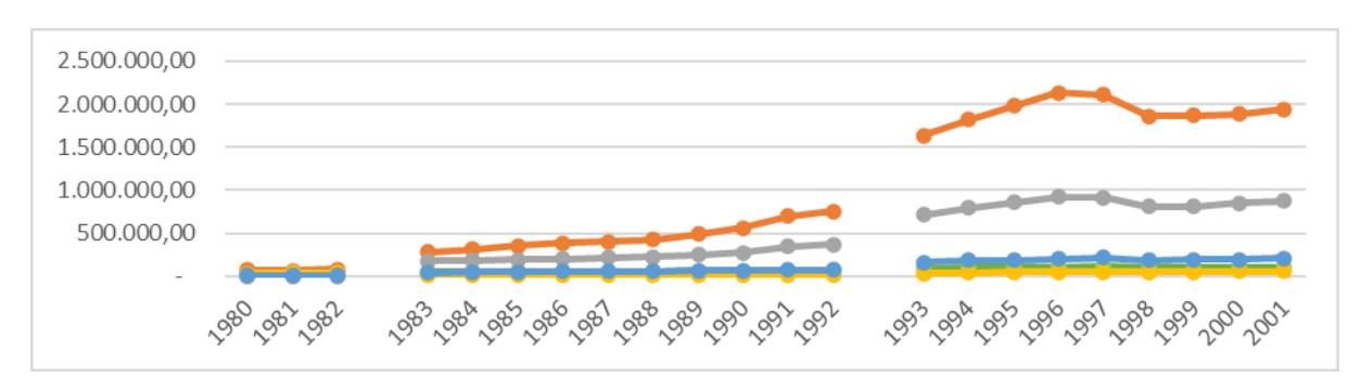
Figure 1. The growth of Kudus Regency's GRDP (constant price) from 1980 to 2019. Source: Drawn based on the compilation of GRDP data from 1980 to the present
The contribution of the transport and trade sectors remained stable at nearly 30% from the early 1980s to 2010. Subsequently, it decreased to approximately 10% and remained steady at that level from 2011 to 2020. Available data indicate a procedural change in recording the value across three sectors: industries, trade, and transport. Between 1983 and 2010, certain subclassifications formerly included in the transport sector were reclassified under the trade sector. Consequently, the trade sector's proportion increased corresponding to the transport sector's decrease. From 2011 to 2020, the transport sector was integrated into the industrial sector. Despite these changes, data from 1980 to 2020 show that the combined contribution of the three sectors grew from around 80% in the early 1980s to slightly above 90% in the mid-1990s through 2011. It then experienced a slight decline to between 88% and 89% from 2016 to 2020. The agricultural sector's contribution declined from 9% in the early 1980s to 6% in 1992, and further to 2.5% in 2020. These data indicate that Kudus is characterized by a predominance of urban activities over non-urban activities.
Data and Research Methods
This research employed secondary data supported by field observations and interviews with locals, mainly from the government apparatus and real estate developers. Census-based data published by Statistics Indonesia served as the main secondary data for analyzing the growth of the urban population and towns in the regency, focusing on both the spatial and demographic processes of urbanization. Additional statistical data and secondary data from Kudus Regency's offices and services were also utilized to analyze economic, industrial, and housing development in the contemporary process of urbanization within the regency.
The analysis of the growth of the urban population and towns employed village classification according to Statistics Indonesia, which categorize villages within the regency as either urbanized or non-urbanized. Urbanized villages are considered spatial elements forming urban areas in the regency. This research used the classifications for 1990, 2000, 2010, and 2020 to analyze the growth. The spatial pattern of urbanization in Kudus Regency was analyzed based on the growth of urbanized villages during this period. Urban population growth was examined by summing the population residing in expanding urbanized villages, which was aggregated for each kecamatan.
In the analysis of spatial growth, this study classified urban areas in Kudus Regency into three categories: the core area, bordering areas, and surrounding areas. The core area comprises Kecamatan Kota Kudus. Bordering areas, also referred to as the smaller corona, the smaller
urban expansion areas formed by all districts adjacent to the core, include all kecamatan bordering Kecamatan Kota Kudus: Kecamatan Bae to the north, Kecamatan Jati to the south and east, and Kecamatan Kaliwungu to the west. The third category, the non-adjacent kecamatan, the surrounding areas or the larger corona, consist of the remaining kecamatan not adjoining the core area: Kecamatan Dawe in the far north, Kecamatan Jekulo in the far east, Kecamatan Mejobo in the southeast, Kecamatan Undaan in the far south, and Kecamatan Gebog in the northwest. However, due to the high number of urban populations residing in each district or kecamatan as well as the high population density of the districts, each district can be seen as a town (district town) that are formed as subcenters or nucleated dispersion stimulated by population dispersion beyond the core area.
In addition to utilizing statistical data, this study incorporated information gathered from observations and purposive interviews conducted in 2022. These methods aimed to elucidate the spatial and demographic growth in the urbanization process. Interviews were conducted with representatives of several regency services and offices related to public work and spatial planning, housing, and environmental issues, as well as labor, industry, and other enterprises. Additionally, interviews were held with 15 housing developers. All observations and interviews were purposefully conducted based on the demographic and spatial findings on the urbanization process.
Results and Discussion
The Spatial Pattern and Urban Population Growth of Growing Towns and Urban Areas in Kudus Regency
The spatial pattern of urbanization and population growth can be explained with the help of Figure 2 and Table 2. The map in Figure 2 illustrates the spatial growth of urban areas in Kudus Regency between 1990 and 2020. In 1990, urbanization in the regency was concentrated in the core area, with some spots of urbanization in surrounding regions. Meanwhile, Table 2 provides information on urban population growth, categorized as kecamatan, as depicted in the map. The table shows the development of urbanized villages in the regency, indicating the number of urbanized villages (UV) in comparison to the total number of villages in each kecamatan. Urbanized areas on the map are distinguished by specific colors and patterns, representing the years 1990, 2000, 2010, and 2020. Collectively, these elements demonstrate the spatial pattern of urbanization and urban population growth in the urbanization process of Kudus Regency from 1990 to 2020.
The map in Figure 2 depicts the spatial growth during the urbanization process in Kudus Regency, indicating a significant expansion from the core area in Kecamatan Kota Kudus, which is also the capital of the regency, into bordering kecamatan. As shown in the map, consistent with the data in Table 2, all of the 25 villages in Kecamatan Kota Kudus were classified as urbanized villages since 1990, housing a population of 93,562 urban dwellers within an area of about 10.5 km2 . This area has become part of a larger urban concentration with a population of about 233,000 inhabitants. In addition to the 25 urbanized villages in Kecamatan Kota Kudus, which make up the core area, this larger urban concentration also includes 26 urbanized villages in bordering kecamatan. These include all villages in Kecamatan Bae, most villages in Kecamatan Jati, and some villages in Kecamatan Kaliwungu. Together, these 51 urbanized villages form the main urban agglomeration of Kudus Regency, collectively covering an area of about 64.4 km2 . This larger urban concentration can be considered the main urban
concentration in the regency that has formed at least since 1990. In addition to the main urban concentration, the regency also houses some much smaller scattered urban concentrations formed by groups of non-adjacent urbanized villages in other five kecamatan in the surrounding areas or the larger corona area, with each town having a population ranging from about 5,000 to 22,000 urban inhabitants.
This condition indicates that Kudus Regency has actually had a quite large town (Kudus Town, the main urban concentration in the regency) with a population of more than 200,000 urban dwellers since 1990, even though it was still designated as a regency, not a city. The size of the urban population concentrated in the main urban concentration and the area of the main urban concentration was equivalent to that of Kota Tegal (Tegal City) and Kota Pekalongan (Pekalongan City) in the same year—Kota Tegal had a population of 229,000 in an administrative area of 39.7 km2 , while Kota Pekalongan had a population of 242,000 in an administrative area of 45.3 km2—and much greater than that of Kota Salatiga (Salatiga City), which had a population of 98,000 in an administrative area of 17.9 km2 (BPS, 1990). The three cities have been designated as autonomous cities (daerah kota) in Central Java since the colonial era.
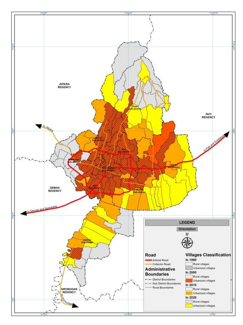
Figure 2. The growth of urbanized villages in Kudus Regency in 1990-2020.
In fact, the population in the main urban concentration of Kudus Regency was larger than the populations in over twenty autonomous cities (daerah kota) throughout Indonesia. Despite the existence of an urban agglomeration with a population of more than 200,000 urban dwellers in its territory, which is equivalent to or even larger than the populations of many cities in Indonesia, Kudus's status as a regency until now may be attributed to its history as a regency under Dutch colonial rule. This situation shows the distinctive characteristic of the urbanization process in Kudus Regency. Even though the process has created a fairly large town, the urban concentration that is formed cannot be seen as forming a city, as the large town formation solely depends on the urbanization process, in the absence of an administrative and political process as a prerequisite of the city formation process. This also shows that the administrative and political processes in Indonesia are slow in responding to urbanization.
It is interesting to note that there have been significant differences in population density among urban areas in the regency. In 1990, the core area of Kudus Town had the highest population density, with nearly 9,000 inhabitants per km2 , while bordering kecamatan had population densities in the range from about 2,000 to 3,000 inhabitants per km2 . As a result, the main urban concentration in the regency had a very high population density that was much higher than the population densities of scattered towns both directly and not directly adjacent to the core area. In other words, the core area had the highest level of urban population density, followed by bordering lower-density urban areas, while the scattered urban areas in the larger corona had the lowest population densities. In 2020, the urban population density in the main urban concentration increased, with the population density in the core area increasing to nearly 9,500 inhabitants per km2 and the population densities in bordering areas increasing to about 3,000 to 4,000 inhabitants per km2 . However, the population densities in towns in the larger corona decreased to about 1,100 to 2,100 inhabitants per km2 , which is considerably lower than the population density in the main urban concentration. This shows that an intensification process took place in the main urban concentration of the regency that started in the core area and then spread into bordering kecamatan.
The urban expansion taking place in the main urban concentration, from the high-density core to bordering lower-density areas, is considered to be the factor that causes the concentration of the population to increase in the urbanization process. This is supported by the construction of a ring road surrounding the core area, which simultaneously enhances the spatial connection between the core and villages in bordering kecamatan. The ring road was designed to divert traffic along the Pantura route away from the inner city or the core area of Kudus Town. The Pantura (an abbreviation of Pantai Utara or North Coast) road, the most important regional road network on Java, stretches along the north coast of the island and connects all of Java's most important cities in its north coast area, spanning from the west to the east. It passes through the central area of Kudus Town, connecting Semarang City, the capital of Central Java Province, located about 60 km from Kudus Town to the west, and Surabaya City, the capital of East Java Province, located about 260 km from Kudus Town to the east. Severe traffic jams that often occur due to the importance of the Pantura road network was the main motivation for the construction of the ring road. Its development began in the mid-1990s, starting from the southern section. The impact of this construction became evident after its completion in the early 2000s. By 2010, all of the 14 villages in Kecamatan Jati had transformed into urbanized villages, up from only 9 during the period from 1990 to 2000 (see Table 2).
Journal of Regional and City Planning vol. 36, no. 1, page. 1-21, April 2025 DOI: 10.5614/jpwk.2025.36.1.1
Table 2. Urban Population and Urbanization Level in Kudus Regency by District in 1990, 2000, 2010, and 2020
| 1990 | 2000 | 2010 | 2020 | |||||||||||||
|---|---|---|---|---|---|---|---|---|---|---|---|---|---|---|---|---|
| Region/Kecamatan | UV | % urban | Urb. Pop | Den sity | UV | % urban | Urb. Pop | Den sity | UV | % urban | Urb. Pop | Den sity | UV | % urban | Urb. Pop | Den sity |
| Core Area (Kecamatan Kota Kudus) | 25/25 | 100 | 93,562 | 8,933 | 25/25 | 100 | 91,489 | 8,736 | 25/25 | 100 | 91,489 | 8,736 | 25/25 | 100 | 89,480 | 9,450 |
| Bordering Kecamatan (Smaller Corona): | ||||||||||||||||
| - North: Kecamatan Bae | 10/10 | 100 | 49,041 | 2,103 | 10/10 | 100 | 55,205 | 2,367 | 10/10 | 100 | 61,966 | 2,657 | 10/10 | 100 | 73,903 | 3,169 |
| - East & South: Kecamatan Jati | 11/14 | 88.33 | 61,418 | 2,966 | 11/14 | 87.73 | 69,734 | 3,367 | 14/14 | 100 | 97,291 | 3,700 | 14/14 | 100 | 108,819 | 4,138 |
| - Jati Town | 9/14 | 76.40 | 53,120 | 2,952 | 9/14 | 74.94 | 59,570 | 3,311 | Merged to be Kecamatan Jati Merged | l to be Kecamatan Jati | ||||||
| - Ngembal Kulon Town | 2/14 | 11.93 | 8,298 | 3,055 | 2/14 | 12.79 | 10,164 | 3,741 | Town | Town | ||||||
| - West: Kecamatan Kaliwungu | 5/15 | 42.23 | 28,996 | 2,932 | 5/15 | 42.61 | 32,590 | 3,295 | 12/15 | 84.65 | 76,368 | 2,881 | 15/15 | 100 | 103,293 | 3,298 |
| - Kaliwungu Town | 4/15 | 32.36 | 22,222 | 2,949 | 4/15 | 32.57 | 24,907 | 3,306 | Merged to be Kecamatan | Merged to be Kecamatan | ||||||
| - Mijen Town | 1/15 | 9.86 | 6,774 | 2,876 | 1/15 | 10.05 | 7,683 | 3,262 | Kaliwungu Town | Kaliwungu Town | ||||||
| Main Urban Concentration | 51/64 | 83.00 | 233,017 | 3,619 | 51/64 | 82.40 | 251,091 | 3,899 | 61/64 | 95.94 | 327,114 | 3,777 | 64/64 | 100 | 375,495 | 4,046 |
| Surrouding Kecamatan (Larger Corona) | ||||||||||||||||
| - North: Kecamatan Dawe | 3/18 | 24.08 | 18,469 | 1,715 | 3/18 | 22.89 | 19,517 | 1,812 | 5/18 | 36.86 | 34,720 | 1,678 | 9/18 | 69.23 | 40,329 | 1,949 |
| - East: Kecamatan Jekulo | 4/12 | 36.70 | 27,385 | 1,327 | 4/12 | 39.94 | 32,976 | 1,598 | 7/12 | 61.22 | 59,923 | 1,595 | 12/12 | 100.0 | 68,228 | 1,816 |
| - South and East: Kecamatan Mejobo | 4/11 | 43.54 | 22,184 | 2,128 | 4/11 | 44.82 | 26,366 | 2,529 | 8/11 | 77.26 | 53,370 | 1,911 | 11/11 | 100.0 | 60,022 | 2,150 |
| - South: Kecamatan Undaan | 1/14 | 9.87 | 5,527 | 1,611 | 1/14 | 9.90 | 6,131 | 1,787 | 5/16 | 40.07 | 27,645 | 1,378 | 10/16 | 69.77 | 53,440 | 1,274 |
| - Kalirejo Town | Not-e | xist Yet | Not-exist Yet | 3/16 | 24.45 | 16,867 | 1,835 | 6/16 | 36.86 | 28,234 | 1,543 | |||||
| - Undaan Lor Town | Not-e | xist Yet | Not-e | exist Yet | 1/16 | 10.11 | 6,978 | 1,205 | 3/16 | 27.17 | 20,813 | 1,121 | ||||
| - Ngemplak Town | Not-e | xist Yet | Not-e | exist Yet | 2/16 | 5.51 | 3,800 | 748 | 1/16 | 5.74 | 4,393 | 865 | ||||
| - North and West: Kecamatan Gebog | 5/11 | 48.91 | 37,242 | 2,353 | 5/11 | 49.17 | 40,942 | 2,586 | 9/11 | 89.63 | 83,796 | 2,730 | 10/11 | 94.61 | 99,356 | 2,551 |
| Scattered Urban Concentrations | 17/66 | 33.10 | 110,807 | 1,814 | 17/66 | 33.90 | 125,932 | 2,061 | 34/66 | 61.24 | 259,454 | 1,895 | 52/68 | 87.13 | 412,745 | 1,666 |
| Urban Areas in Kudus Regency | 68/13 0 | 55.0 | 343,824 | 2,740 | 68/130 | 55.72 | 377,023 | 3.004 | 95/132 | 76.72 | 586,568 | 2,624 | 116/132 | 92.82 | 788,240 | 2,315 |
Source: Calculated from Podes (Potensi Desa) Data or Villages' Monograph in 1990 and 2000 and Kudus Dalam Angka in 2010 and 2020
Note: UV = the number of urbanized villages in the kecamatan, compared to the number of all villages in the kecamatan.
% urban = the proportion of the urban population to the total population.
The extension of the ring road with the construction of the northwest section after the 2000s also influenced the transformation of villages in Kecamatan Kaliwungu, increasing the number of urbanized villages in the kecamatan from 5 in 2000 to 12 in 2010. In other words, all villages in Kecamatan Kaliwungu had become urbanized by 2010. The ring road extension, which also passes through the southern area of Kecamatan Gebog (north of Kecamatan Kaliwungu), transformed several other villages, increasing the number of urbanized villages in Kecamatan Gebog from 5 in 2000 to 9 in 2010 (out of eleven villages in the kecamatan). This transformation in Kecamatan Gebog subsequently stimulated changes in Kecamatan Dawe, north of Kecamatan Gebog, which saw an increase in the number of urbanized villages from 3 in 1990 through 2000 to 5 in 2010 through 2020 (out of 18 villages in the kecamatan). However, the extension process of the ring road in the north was not as rapid as it was in the south. The construction of the northern section that is supposed to connect the northern section to the eastern regional road is currently in its planning stage, expected to be finished in the coming years.
The spatial process of urbanization in Kudus highlights the importance of two spatial factors. The first is the presence of Kudus Town, which serves as the core area with the highest concentration of population and activities, and closely connected, lower-density bordering kecamatan. The second factor is the existence of a regional road network that significantly improves the connection of the core to its surrounding areas. The combination of these two factors provides incentives for the spread of the urban population and its activities beyond the core area, affecting spatial expansion of Kudus Town into the smaller corona in the first period, as well as into the larger corona in the next period. It has transformed Kudus Town from a town with a population of fewer than 100,000 inhabitants in 1980 into a much larger town with nearly 400,000 inhabitants in the main urban concentration and more than 700,000 inhabitants in the total urban area in 2020. The outward expansion process of the town, particularly along the corridor of its regional road access, mirrors the process described by McGee (1991) in the formation of many major and large Asian cities during their urbanization. Furthermore, the spatial process has also shown the enlargement of Kudus Town into a city-size urban concentration by the urban expansion of the town as well as the formation of new urban concentrations as subcenters on the outskirt of the town. This process reflects Li's (2020) arguments on the towns that grow in the peripheries of an urban center and form a polycentric urban area.
Sectoral Development during the Urbanization Process in Kudus Regency: Industrial Activities and Housing Complexes
As previously discussed, the urbanization process in Kudus Regency has been influenced by the growth of industrial activities in the region. The kretek cigarette industry laid the foundation for numerous industrial activities in the region over a century ago. Although the kretek cigarette industry and other tobacco-related industries still dominate the industrial activities in the regency, Kudus has diversified its industrial activities, including food and beverage, garment and textile, electronics, paper, cardboard, and packaging industries. The long history of industrialization in Kudus has made the regency the most industrialized and urbanized in Central Java Province, with an urbanization level exceeding 90% in 2020.
Figure 3 illustrates the growth of large-scale industrial activities in each kecamatan in Kudus Regency, indicating that large-scale factories continue to be concentrated in the core (Kecamatan Kota Kudus) and adjacent areas or the smaller corona (Kecamatan Kaliwungu, Kecamatan Jati, and Kecamatan Bae). According to Table 2, these 4 kecamatan also have the highest population densities in the regency, with Kecamatan Kota Kudus being the most densely populated. Figure 3 also reveals a spatial shift in the location of large-scale industrial activities in Kudus Regency over the past decades. There has been a decrease in the core area and a sharp increase in bordering areas, specifically in Kecamatan Kaliwungu, Kecamatan Jati, and Kecamatan Bae. A significant increase is also observed in Kecamatan Jekulo, located about 10 km from the city center. Kecamatan Dawe in the outer north and Kecamatan Undaan in the outer south of the regency exhibit different trends in industrial development. These areas are not preferred for large industrial activities as they are classified as flood-prone and designated for agricultural activities. Due to these reasons, Kecamatan Dawe and Kecamatan Undaan are considered unfavorable for industrial activities, although the trends indicate that nearly all parts of Kudus Regency have attracted large-scale industrial activities in recent decades. This explains why the urbanization process has spread to all kecamatan in the regency, except for Kecamatan Dawe and Kecamatan Undaan. These conditions also indicate a dispersion of jobs from the core area into the surroundings, especially the bordering areas, in line with Li's view of nucleated dispersion.
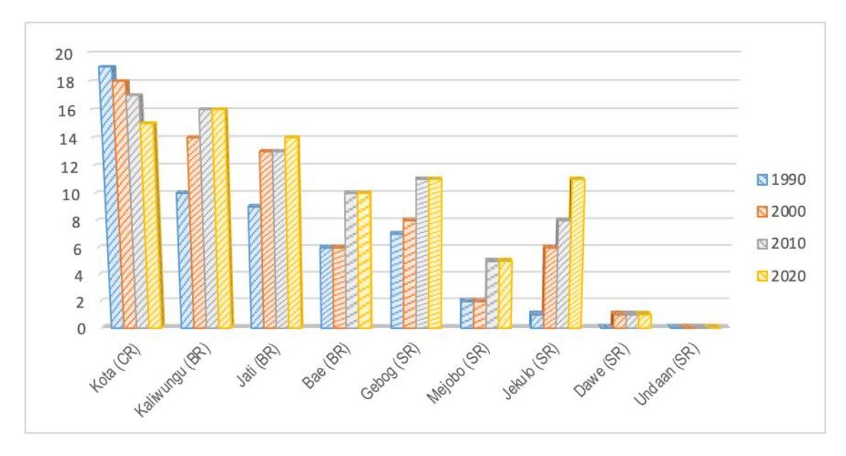
Figure 3. The growth of large-scale industrial activities in Kudus Regency in 1990-2020.
In terms of housing development, as with other Indonesian cities, the majority of urban inhabitants in Kudus live in kampungs—densely populated settlements where most houses are built individually and informally. Formal housing development in Kudus Regency began in 1983 with the establishment of Kudus Permai, a housing complex in Garung Lor Village, Kecamatan Kaliwungu, approximately 4 km from the city center of Kudus Town. This occurred about a decade after the introduction of formal housing development in the country, initiated by Perum Perumnas, a national state-owned enterprise for housing development, with the creation of a middle- and low-income housing complex, Perumnas I Depok, from 1974 to 1976. The development of Perumnas I Depok, located in Kecamatan Beji, Depok, about 25 km from the southern outskirts of Jakarta, aimed to provide housing for Jakarta's growing population.
Following the development of Kudus Permai, formal housing development in Kudus continued with the establishment of Perumahan Djarum Singocandi in Singocandi Village, Kecamatan
Kota Kudus, in 1990. The Djarum Singocandi housing complex was a collaborative effort between Djarum Kudus, the largest kretek cigarette company, and a housing developer, supported by a housing loan to provide housing for the company's labor force (Umar & Hakim, 2019). According to Umar & Hakim (2019), the first phase of development from 1990 to 1992 saw the construction of about 200 simple houses on a former paddy field near the Kudus Mosque and the Kudus Town Square, which are central to the town. Initially, the houses were sold to the company's laborers; however, many later sold their houses to others due to the proximity to the city center. Today, these houses can no longer be considered simple, as they have been significantly improved.
In 1990, the Muria Indah 1, Muria Indah 2, and Muria Indah 3 housing complexes were developed in Gondangmanis Village, Kecamatan Bae, a bordering kecamatan to the north of Kecamatan Kota Kudus. This village is located about seven km from the city center of Kudus Town. More housing complexes were then developed in the regency during the 1990s. Megawon Village and Jepangpakis Village in Kecamatan Jati and Dersalam Village in Kecamatan Bae were sites for housing complexes in this era. As both Kecamatan Jati and Kecamatan Bae border Kecamatan Kota Kudus, these villages also lie adjacent to Kecamatan Kota Kudus. Furthermore, housing complexes were built in Trenggeles Village in Kecamatan Mejobo and Terban Village in Kecamatan Jekulo during this period. These two villages are located along the main regional road corridor from Kecamatan Kota Kudus to the east, at distances of approximately 5 km and 10 km, respectively. These developments indicate that the core area remained dominant during this era.
Table 3. Development of Housing Complexes in Kudus Regency by District and Era
| Number of Housing Complexes Developed | |||||||||||
|---|---|---|---|---|---|---|---|---|---|---|---|
| No | Kecamatan (Area) | 1980s | 1990s | 2000s | 2010+ | No Info | Total | ||||
| 1 | Kota Kudus (Core Area) | - | 1 | - | 1 | 2 | 4 | ||||
| 2 | Bae (Bordering Area) | - | 4 | 4 | 10 | 3 | 21 | ||||
| 3 | Jati (Bordering Area) | - | 2 | 2 | - | - | 4 | ||||
| 4 | Kaliwungu (Bordering Area) | 1 | - | - | - | 3 | 4 | ||||
| 5 | Jekulo (Surrounding Area) | - | 1 | - | - | - | 1 | ||||
| 6 | Mejobo (Surrounding Area) | - | 2 | - | 2 | - | 4 | ||||
| Total | 1 | 10 | 6 | 13 | 8 | 38 | |||||
Source: Analyzed based on various sources, including secondary data and small interviews, 2023
Today, nearly 40 housing complexes have been developed in Kudus Regency. Compared to the growing urban population in the regency, this number indicates that formal housing is less dominant in meeting the housing needs of the expanding urban population. Although the development of housing complexes began in 1983, with significant efforts in the 1990s, the most substantial growth did not occur until 2010 (see Table 3). The development of housing complexes in the 2000s was relatively limited compared to the previous decade. Interviews with housing developers revealed that it was low demand that significantly hindered the construction of housing complexes during that period.
In terms of spatial relation, the development of formal housing complexes is linked to the concentration of urban activities, including industrial ones. This development is concentrated in Kecamatan Kota Kudus and three neighboring kecamatan. However, it is challenging to determine whether housing complex development influences the urbanization process or is influenced by it. This difficulty arises because the majority of housing is provided through spontaneous, informal, individual developments rather than through formal policies. Additionally, informal housing development has resulted in the creation of kampungs in various parts of the regency, including surrounding and in-between areas of formal housing complexes. These informal developments benefit from the growing space and urban facilities developed by formal housing initiatives and the increasing urban activities in the regency.
Conclusion
Using the case of the urbanization process in Kudus Regency, this research revealed the importance of urbanization occurring outside of traditional city boundaries, in regions with local authorities still considered or perceived as non-urban in Java. The urbanization process in Kudus Regency results in the formation of urban areas with over 500,000 inhabitants, a figure that, according to Indonesian urban classification, defines large cities or major urban areas.
Urbanization process in Kudus was shown by the densification of Kecamatan Kota Kudus, as the core area of the town, which was followed by non-urban-to-urban reclassification of villages in the surrounding areas of the core, both in the adjacent areas (the smaller corona) and in the non-adjacent/surroundings (the larger corona). As Zhu (2017) argues that rural-to-urban reclassification is part of the three components of urban population growth in towns and cities, the case of Kudus' urbanization shows that the reclassification process was the main component of the spatial expansion of Kudus Town into the surrounding villages, in both areas, the smaller and larger coronas. The close distance of the kecamatan in the smaller corona into the core of the town (less than 10 km) led to the process mainly being seen as the spatial expansion of the town, and the larger distance of the kecamatan in the larger corona (between 10 to 20 km) led to the process being the creation of fringe subcenters in the town. In this context, the urbanization in Kudus Regency could be categorized as in-situ urbanization, as it is predominantly driven by internal factors rather than external ones, despite the regency's proximity to Semarang City, a region which could be considered part of a medium-sized metropolitan area with over one and a half million urban residents in its core and about three million urban population in the metropolitan area. Therefore, referring to Li (2020), from a macro or regional perspective, the town formation in the urbanization process in Kudus Regency reflects the generalized dispersion view, as it is influenced by internal factors of Kudus Town, rather than the dispersion of jobs and population from Semarang City to Kudus Regency. However, from a micro perspective, the urbanization process in Kudus Regency also reflects the nucleated dispersion view, as the enlargement of Kudus Town from the core area into the surrounding areas in both adjacent and non-adjacent areas shows the dispersion of jobs and population from the core area to its surroundings.
The analysis in this study showed that the spatial urbanization process in Kudus is influenced by the dynamics of the interlink between industrial and population activities in the region, supported by road access as well as residential or housing development. This interconnected process has led to the spatial evolution of urban areas in Kudus, spreading from the core area to bordering areas, which are also supported by the growth of urban areas in their surrounding areas, forming a larger urban area comparable to major cities in Indonesia. The evolution is driven by large-scale industrial activities, supported by a substantial population within the region as well as the road access improvements in the area. The resulting urban structure resembles a concentric city model.
The distinctive characteristics of Kudus Regency when compared to other regencies—a long history of industrial activities, small territory, and high population density—have led to the formation of a large urban concentration centered in Kecamatan Kota Kudus, which expands into bordering and surrounding kecamatan. Therefore, the urbanization process in Kudus Regency offers a unique variation of urbanization in the territory of regencies (non-urban areas) with strong internal factors. In a manner resembling the growth of cities, the urbanization process in Kudus Regency cannot be regarded as a typical urbanization and urban growth process within a regency due to its unique characteristics.
Even though Kudus Regency is not an adjacent-to city regency, urbanization in Kudus Regency is more similar to the urbanization process that occurs in some adjacent-to-small-cities regencies in Java, like in Tegal Regency, which is adjacent to the city of Tegal, in Pekalongan Regency (adjacent to Pekalongan City) and in Magelang Regency (adjacent to Magelang City), where the urbanization process has tended to be a process that enlarges the urban area and spreads the activities of the city into their territory (see Mardiansjah et al. (2021b)). The difference is in the location of the core area of the urbanization process that is located within the territory of the regency for Kudus Regency and outside the territory of the regency for the adjacent-to-smallcities regencies.
Nevertheless, from the perspective of regional development management in Indonesia, Kudus Regency's experience highlights the importance of urbanization and urban development capacities in managing regional development processes, especially for regions entering the urbanization era as indicated by their urbanization level or the dominant proportion of the urban population as well as the high influence of industrial activities on the regional economy as well as the community of the region. Enhancing capacities in managing urbanization and urban development processes will help these regions manage their urbanization and regional development processes within their administrative boundaries. Better management of such urbanization could support the growth and development of the towns developed in the outside of cities' urbanization process, where the growing towns may be useful in improving and strengthening their regional structure as well as their economy. However, the improvement in urbanization and urban development management capacities of these regions requires policies that recognize and differentiate urbanized regencies like Kudus from other still-non-urbanized regencies. By acknowledging these distinctions, urbanized regencies could benefit from special policies that enable them to develop their capacities for managing their urbanization and urban development processes, even though they are still designated as non-urban regions.
Acknowledgments
The authors would like to extend their gratitude to Prof. Walter Timo de Vries, who has kindly reviewed the first part of this paper, as well as to the anonymous reviewers who have kindly provided valuable critics and suggestions to improve the manuscript.
Declaration of conflicts of interest
The author(s) declare no potential conflicts of interest with respect to the research, authorship, and/or publication of this article.
Funding
The authors received no financial support for the research, authorship, and/or publication of this article.