
Introduction
Spatial knowledge is a critical component of community-based planning. It equips communities with the ability to understand, interpret, and analyze spatial information, enabling them to actively engage in decision-making processes (Natarajan, 2017). By possessing spatial knowledge, communities can effectively identify and address local issues, contribute to the development of sustainable and equitable spatial plans, and ultimately shape their future. At a certain level, this step empowers communities to take ownership of their surroundings and foster a sense of agency in their development (Akbar et al., 2020a). In the context of spatial planning, this includes the ability of communities to comprehend and utilize maps, data, and other spatial tools to make informed decisions about their environment (Atzmanstorfer et al., 2014; Debolini et al., 2013; Ghose, 2003). By possessing spatial knowledge, communities can actively participate in planning processes (Haklay et al., 2018), identify and address local issues (Mamokhere & Meyer, 2023), and contribute to the development of sustainable and equitable spatial plans (Brown & Kyttä, 2018; Fagerholm et al., 2013).
Individuals construct a unique mental map of their environment, influenced by their personal experiences and perceptions (Golledge et al., 1985; Weisberg & Newcombe, 2018). At its most basic, this involves knowing about important objects and places, often referred to as landmark knowledge (Boongaling et al., 2022). This includes recognizing and identifying these elements within their surroundings. Beyond landmarks, spatial knowledge also encompasses understanding the relationships between objects. This can involve simple concepts like proximity, or more complex spatial arrangements. Previous studies used sketch maps to explore community spatial knowledge (Kattenbeck et al., 2024) or even analyzed social media posts like tweets (Xiao et al., 2023). In a broader sense, such knowledge is increasingly recognized as vital for navigating the Anthropocene (Suh & Hu, 2023). Institutions like the International Indigenous Peoples Forum on Climate Change underscore the critical, yet sometimes underappreciated importance of indigenous lands, which are home to a substantial portion of the world's biodiversity (ibid). The integration of GIS with local spatial knowledge, often in collaboration with indigenous communities (Brown & Kyttä, 2018; Tripathi & Bhattarya, 2004), has yielded positive outcomes in numerous instances, such as biodiversity protection (Hernández-Morcillo et al., 2013; Hill et al., 2020; Verbrugge et al., 2022), health and disease prevention (Beyer et al., 2010; Logie et al., 2023; F. Wang, 2020), and even in supporting disaster management (Canevari-Luzardo et al., 2017; Mahmood & Rani, 2022). In deliberative public participation processes, stakeholders frequently employ spatial knowledge to identify specific geographic locations that require improvement or intervention (Akbar et al., 2020b). Meanwhile, to effectively study and positively influence a system, researchers, and clients must actively collaborate (Peerapun, 2012).
Incorporating local perspectives and understanding of the region's unique attributes can lead to strategies that are better aligned with the needs and aspirations of the community (Akbar et al., 2020a; Ives et al., 2017). Participatory mapping, a collaborative approach involving local communities, has emerged as a powerful tool for empowerment and environmental management (Brown & Kyttä, 2018; Denwood et al., 2023; Zurba et al., 2012, 2019). By leveraging geospatial technologies like GIS, participatory mapping enables communities to identify, discuss, and address environmental matters (Andrade-Sánchez et al., 2021; Nirwansyah et al., 2023; Perera et al., 2021). The Intergovernmental Panel on Climate Change (IPCC) emphasizes the importance of integrating local knowledge into disaster risk reduction efforts (Hall et al., 2019; Klein R.J.T. et al., 2014). Participatory mapping empowers communities to contribute their valuable spatial knowledge, particularly in data-scarce regions (Bednarz & Kemp, 2011; Brown & Kyttä, 2018).
In developing nations, participatory mapping has proven to be a valuable tool for empowering local communities in environmental management. It has been successfully applied in various contexts, such as integrated land-use planning and encouraging community tourism in South Africa (Ramaano, 2022); natural resource inventorying in the forest and management in Borneo (Ioki et al., 2019) and Amazon, Brazil (Da Silva et al., 2023); and the recognition and protection of indigenous territories (Hettiarachchi et al., 2022; Sulistyawan et al., 2018). By facilitating community-driven mapping and decision-making, this approach empowers communities to actively participate in shaping their environment and protecting their resources (Damastuti & de Groot, 2019; Sullivan et al., 2015; X. Wang et al., 2008). Participatory mapping offers a promising avenue for local communities in developing nations to address environmental challenges and promote sustainable development. By combining local knowledge with geospatial technologies, this approach empowers communities to identify and prioritize environmental issues, develop solutions, and advocate for their rights (Brown et al., 2012). Through participatory mapping, communities can actively engage in environmental management (Cho et al., 2024), strengthen their resilience to climate change (Albagli & Iwama, 2022; Glaas et al., 2020), and contribute to the preservation of their cultural heritage (Cusens et al., 2022; Nirwansyah et al., 2023).
Spatial knowledge
Spatial knowledge, a foundational concept in cognitive geography, has been defined and conceptualized in various ways. While definitions may vary, a common thread is the understanding of spatial knowledge as the arrangement of distinct spatial entities (Papadias & Sellis, 1994). Pfeffer et al. (2013) provide a comprehensive definition, characterizing spatial knowledge as a practical understanding of interconnected spatial concepts including place identity, network relationships, directions, and distances. A distinctive feature of spatial knowledge is its multi-sensory nature. Unlike other perceptual domains, spatial knowledge can be validated or refuted through information obtained from different sensory channels (Zimmermann, 2001). This multi-sensory integration allows for a more robust and accurate understanding of the spatial environment (Stein et al., 2014). Humans utilize spatial knowledge for a wide range of activities, including navigation, wayfinding, map interpretation, and route planning (Akbar et al., 2020b). Moreover, spatial information, particularly directional information, is directly accessible through perception, enabling both animals and humans to navigate their surroundings effectively (Zimmermann, 2001). Numerous representational forms have been proposed, including sketch maps, verbal descriptions, pseudo-cartographic representations, configurations derived from multi-dimensional scaling procedures, and interactive computer mapping procedures (ibid). These diverse approaches reflect the complexity and multifaceted nature of spatial knowledge (Golledge et al., 1985). Contemporary GIS simulation technology empowers the visualization of spatial information in diverse formats, ranging from traditional 2D maps to immersive augmented reality experiences as performed in (Chatel & Falk, 2017; Lin et al., 2020).
In the realm of indigenous community planning, understanding the interplay between spatial knowledge and community development is paramount. Pfeffer et al. (2013) proposed a useful categorization of spatial knowledge into four primary types: tacit, community, sectoral, and expert. As explained priorly in Akbar et al. (2020b), tacit knowledge is the unspoken or unwritten knowledge held by individuals within a community. Indigenous communities possess a wealth of this knowledge, passed down through generations. This knowledge is deeply embedded in their understanding of their land, resources, and cultural practices (Anthias, 2019). Community knowledge encompasses the collective understanding of a community's social, political, and spatial environment. Indigenous peoples possess intricate knowledge of their
territories, frequently grounded in oral traditions, ceremonies, and cultural practices (Pyne et al., 2022). Sectoral knowledge is specialized knowledge acquired through formal training or experience. While valuable, it should be integrated with local knowledge. Expert knowledge is codified knowledge developed by academics or professionals. It can provide valuable insights, but it may not always capture the nuances of local conditions or the unique perspectives of indigenous communities. In the context of indigenous community planning, it is essential to acknowledge the interrelations of these different types of spatial knowledge (as depicted in Figure 1). Tacit and community knowledge, often marginalized in traditional development paradigms, hold immense value in understanding and addressing the specific needs and aspirations of indigenous communities. By recognizing the importance of these forms of knowledge and integrating them into planning processes, more equitable and sustainable development pathways can be created.
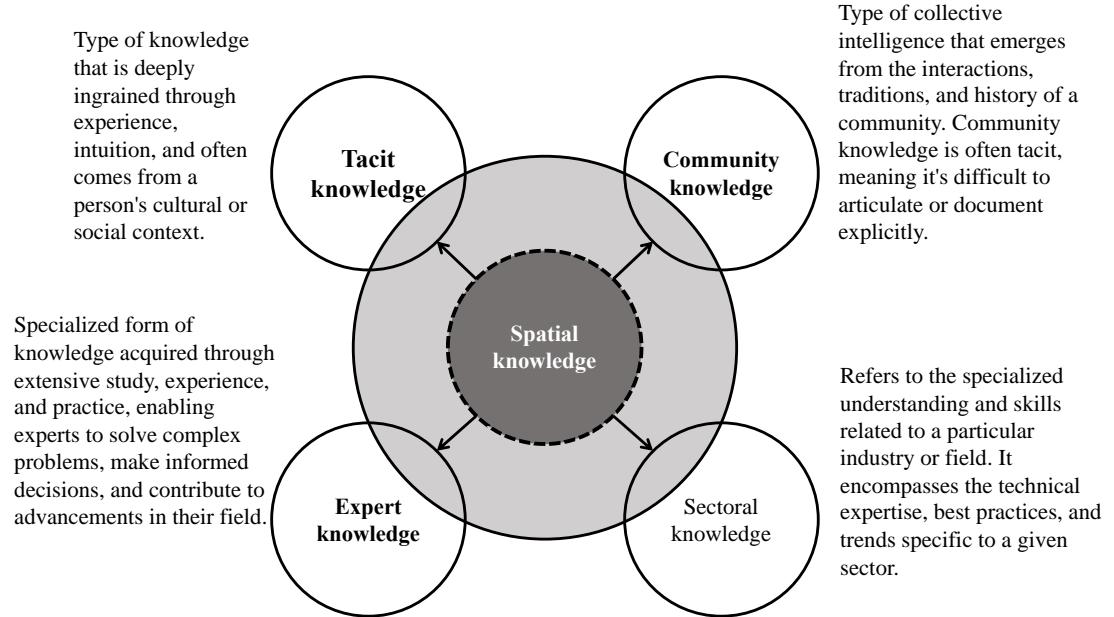
Figure 1. Realm of spatial knowledge in context of community planning. Adapted from: Pfeffer et al. (2013); and Akbar et al. (2020b)
Psychological research has investigated various levels of spatial knowledge, often drawing inspiration from Siegel and White's framework to categorize these different levels (see Siegel & White, 1975). As depicted in Figure 2, the framework categorizes spatial knowledge into three distinct levels: landmarking, route-tracking, and surveying. Along with that, the usage of spatial knowledge to enhance community participation is also presented within the local context (Akbar et al., 2020b; Frediani & Cociña, 2019; Kahila-Tani et al., 2019). At the landmark level, individuals can recognize specific locations but struggle to connect them or navigate between them (Stern & Leiser, 1988). By acquiring expertise and knowledge, individuals can progress to a more advanced level. At this route level, they can establish connections between different locations and model travel pathways (Rupp et al., 2019; Schweizer et al., 1998; Shatu et al., 2019). While they may have gained specific skills, they may still lack a comprehensive understanding of the broader spatial context (Stern & Leiser, 1988). The survey level, the highest level, involves concerning the configuration of landmarks and routes (Siegel & White, 1975), enabling individuals to navigate freely without relying solely on travel paths (Kattenbeck et al., 2024; Stern & Leiser, 1988). These three levels represent developmental stages rather than a hierarchy (Montello, 1998). Ishikawa & Montello (2006) highlight the adaptive nature of spatial knowledge, emphasizing its role in guiding behavior and adapting to the environment. Learning and experience can facilitate the transition between levels, making Siegel and White's framework a valuable tool for understanding spatial knowledge development (Ishikawa & Montello, 2006; Kirschner et al., 2018).
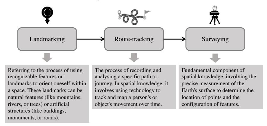
Figure 2. Categorizing on a spatial knowledge level. Adopted from Akbar et al. (2020b; Siegel & White (1975); and Stern & Leiser (1988)
Problems
Despite the growing recognition of the importance of spatial knowledge in environmental management, its integration into participatory planning processes remains a complex and often overlooked challenge. The participatory planning methodology employed in conservation and regeneration projects is distinctive, combining action research and integrative planning (Peerapun, 2012). In this context, the integration of spatial literacy into community planning enables informed decision-making for conservation, disaster management, and sustainable development (McCall, 2021; Ros-Tonen et al., 2021). Amid the growing availability of geodata, especially by expanding the application of GIS, there remains a lack of structure to describe and guide its systematic application (Fagerholm et al., 2021). The integration of spatial knowledge into participatory planning processes is crucial for several reasons. Spatial knowledge provides valuable insights into local ecosystems, resource management practices, and cultural values that may be overlooked by scientific or expert knowledge (Boongaling et al., 2022; Ioki et al., 2019; Selgrath & Gergel, 2019). Incorporating spatial knowledge can increase the legitimacy and acceptance of planning decisions among local communities, leading to more informed and context-relevant decision-making, and empowering local communities by recognizing their expertise and contributions to planning processes. While spatial knowledge can enhance participatory planning, significant gaps remain in the research context, such as differing knowledge systems, unequal power dynamics, and limited capacity, especially within indigenous communities. This study investigated how spatial knowledge can be effectively integrated into community planning processes to address environmental issues in local communities. By addressing these issues, this study contributes to the development of effective and equitable approaches for integrating spatial knowledge into participatory planning processes, leading to improved environmental management outcomes. Additionally, the study focused on methodologies and tools that can be effectively employed to capture, analyze, and visualize spatial knowledge, such as participatory mapping techniques, GPS survey and GIS.
Material and Methods
Case Studies
This study investigated the role of community-based spatial knowledge in addressing environmental challenges. To achieve this, it focused on two case studies: the Orang Rimba in
Jambi, Indonesia, and the Lavongai community in Papua New Guinea (PNG). These cases represent distinct regional contexts, offering insight into participatory mapping in different settings. A more detailed explanation of these case studies is provided in the subsequent subchapters.
Case 1: Orang Rimba community, Indonesia
For the first case, this study examined the potential use of spatial knowledge of the Orang Rimba in addressing environmental threats in national parks. The activity included workshops and mapping activities in Bangko, Merangin regency, and within Bukit Duabelas National Park (BDNP) in Tebo regency. With a population exceeding 355,718, predominantly Malay, the region is primarily engaged in agriculture (Badan Pusat Statistik Kabupaten Merangin, 2022). The hilly to mountainous landscape ranges from 60 to 1,035 meters above sea level, and BDNP is a tropical rainforest ecosystem. The soil in BDNP is primarily podzol red-yellow and alluvial, susceptible to erosion. The BDNP area was initially designated as 60,500 hectares in 2000 but decreased due to palm oil and rubber plantation expansion. A 2014 regulation reduced the area to 54,780.51 hectares. Currently, BDNP is a central government technical implementation unit under the Ministry of Environment and Forestry, responsible for protection, preservation, and utilization (Dwiyahreni et al., 2021; Kurniawan et al., 2022).
The post-Suharto era in Indonesia witnessed a significant resurgence of indigenous activism, following decades of suppression under the highly centralized New Order regime. The implementation of regional autonomy laws in the early 2000s provided a conducive environment for the mobilization of diverse ethnic groups based on their unique cultural and political identities (van der Muur, 2018). The Orang Rimba, an indigenous minority inhabiting the lowland rainforests of Jambi province, exemplify this trend. Their communities, residing between the Batanghari River and the Bukit Barisan mountain range (Tuhri, 2020; Wardani, 2011), have a deep-rooted connection to the forest (Prasetijo, 2013), which provides them with sustenance, shelter, and cultural resources. This community is part of the more than 2,400 indigenous communities reported by Indigenous Peoples Alliance of the Archipelago (AMAN) in 2023.
Traditionally, the Orang Rimba practice a semi-nomadic lifestyle centered around swidden agriculture, hunting, trapping, fishing, and honey collection (Prasetijo, 2013; Sager, 2008; Yusuf & Qodir, 2014). An earlier census in Bukit Duabelas National Park (BDNP) in 2018, estimated that more than 700 families, totaling almost 3,000 Orang Rimba were living within the park borders (Hermansyah, 2019). However, their way of life has been increasingly threatened by the expansion of protected areas, such as Bukit Duabelas National Park, which has led to conflicts over land use and access to resources. This indigenous group is primarily engaged in swidden agriculture, a traditional agricultural practice that involves clearing and burning forested land for cultivation (Manurung, 2019; Sager, 2008). They reside in small family groups and construct temporary settlements. Their unique agricultural practices include cultivating plots of land and harvesting wild yams (Persoon & Wardani, 2017), with the location of their settlements often shifting in accordance with the life cycle of community members (Sager, 2008).
Case 2: Lavongai community, Papua New Guinea (PNG)
For the second case, the established method was applied in New Hanover Island, also known as Lavongai or Lovongai, which is a tectonically uplifted volcanic island located within Papua New Guinea's Bismarck Archipelago. With a land area of approximately 1,200 km², the island features a mountainous landscape dominated by the Tirpitz or Lavongai Range, which stretches
along its entire length (Exon & Tiffin, 1982). This range includes prominent peaks rising to 2,000 to 3,000 feet above sea level, while additional mountains slope gently in the northwestern and north-eastern directions (Kaiku & Kaiku, 2008). The island's geological make-up is evident in its coastal features, including raised sea beds and fringing reefs. Lavongai's vegetation varies across its topography, with tropical rainforest covering most of the island and coconut plantations and sago swamps lining the coast. The south coast features patches of savanna grassland, while low-lying, uninhabited mangrove islands dot the surrounding waters. Approximately 31,882 people inhabit the island, primarily residing in dispersed villages (National Statistical Office, 2021). However, these local communities face increasing threats from coastal erosion, coral reef degradation, and rising sea levels.
PNG's geographic composition includes the western half of New Guinea, the second-largest island globally, as well as numerous smaller islands within its national borders (Filer, 2024). In New Ireland Province, flooding primarily occurs in inland areas with a five-year return period. However, significant flooding zones with a ten-year return period are evident in the northwestern portion, while regions around Namatanai, Konos and scattered throughout Kavieng District exhibit a fifty-year return period (UNDP, 2017). The demographic profile of New Ireland is predominantly indigenous, with approximately 92% of the population being native to the province (West, 2023). New Irelanders rely on a diverse subsistence economy, including fishing, marine gathering, agriculture, and remittances from family members in various sectors, with 75% of the population heavily dependent on the marine environment and coral reef systems for livelihood, sustenance, recreation, cultural practices, and overall quality of life (ibid). McGavin (2016) posits that the local community identity is rooted in the concept of peles. 6 This framework necessitates an examination of the geo- and socio-political implications of theories of 'race' and 'home'.
Currently, Lavongai experiences a tropical climate with high humidity throughout the year. Land use on the island is a mix of traditional subsistence agriculture and commercial ventures. While three Special Agriculture and Business Leases (SABLs) encompass roughly 75% of the island, residents continue to generate income through copra, cocoa, and other agricultural products, alongside fishing. The impact of SABLs, particularly regarding massive forest loss, livelihood transformation, and social change, necessitates adaptation strategies for the Lavongai community (Southgate et al., 2019). These challenges are further compounded by the effects of climate change (Roberts, 2024). At the same time, the intricate tapestry of PNG's diverse social formations, cultures, languages, and geography has given rise to complex landownership patterns. The intricate web of membership groupings within social institutions at various scales often obscures the underlying relationships that govern land tenure (Roberts, 2019). While there are some common principles, notably the acknowledgment of descent reckoning, disentangling these relationships can be a formidable task given the multifaceted nature of social structures (Imbun, 2013). Further, the national government also prioritizing climate change and environmental protection is essential for sustainable economic growth, mitigating the potential opportunity costs associated with neglecting job creation, prosperity, and resilience and documented in the National Medium-Term Development Plan IV (2023-2027). Community participation, with its deep-rooted understanding of local landscapes and resources, can play a crucial role in developing effective solutions. By incorporating local perspectives and knowledge, communities can contribute to sustainable land use practices, conservation efforts, and the overall well-being of their environment.
6 Peles is a Melanesian term referring to an individual's deep-rooted connection to a specific ancestral homeland (McGavin, 2016).
Methodology
Method overview
As outlined in the preceding section, the present study adopted the framework of Natarajan (2017), which posits that participatory and spatial planning theories are underpinned by the spatiality of knowledge. While critiques of these theories often focus on planning processes and economic power imbalances, the implications for knowledge dominance and the spatial power of learning through participatory processes are often overlooked. This study employed a participatory mapping approach, conducted in collaboration with a university, NGOs, and local communities. A series of workshops were held to engage community members in mapping their local environment. Field data was collected using GPS devices and this data was subsequently processed using GIS software on a reliable platform. A qualitative approach was used to evaluate how community mapping and GIS can be utilized as practical tools for spatial knowledge extraction (Giordano & Cole, 2018; Teixeira, 2018). This study primarily benefited from the GeoStory Camp program, an initiative of the People's Planet Project (PPP), an international non-governmental organization dedicated to fostering a world where indigenous peoples can safeguard their ancestral lands from encroaching industries and maintain their undisturbed way of life (People's Planet Project, 2020). The PPP had prior experience with similar projects, such as the GeoStory Camps held with the Xingu community in the Amazon in 2021, in cooperation with a local NGO. The process involved two case studies that highlight the participatory approach used in different settings.
Data analysis
As previously discussed, this study employed a structured observation technique (Puzyreva & de Vries, 2021) to assess two recent case studies involving community mapping implementation. A dedicated observation protocol was developed by the research team. To enhance the reliability and objectivity of the observation process, two researchers (the first and second authors) independently conducted the observations. Daily debriefing sessions were held to consolidate data, including photographs and videos, and to ensure consistency in interpretation. Any discrepancies or conflicting perspectives between the observers were resolved through collaborative discussion and consensus-building. Additionally, two other researchers (the third and fourth authors) evaluated the produced maps and gathered feedback from the community through focus group discussions (FGDs). The FGDs aimed to deeper examine local spatial knowledge, community capacity in addressing local issues, and villagelevel planning processes. This study was designed with transparency and respect for local traditions in mind, adhering to ethical principles for community-based research to ensure meaningful community involvement (Babelon et al., 2021; Mamokhere & Meyer, 2023; McCall & Dunn, 2012). For that reason, ethical clearance for this study was provided and approved by the Ethics Committee of Universitas Muhammadiyah Purwokerto.
Results
Workshop and training
The first case study took place in collaboration with Kelompok Makekal Bersatu (KMB), one of the largest groups of Orang Rimba, a community residing along the upper Makekal River in Jambi Province. In May 2022, the participatory mapping (p-mapping) project began with an online meeting to establish the project plan and proposal. The fieldwork component involved six young participants (N = 6) from the Orang Rimba community, who underwent two weeks of intensive training in spatial data collection and GIS skills. The training sessions focused on teaching the use of GPS devices, collecting field data, and integrating this data into GIS software for further analysis. The training was held in Sokola Rimba (Jungle School), located in Bangko as capital city of Merangin region. This facility was mainly chosen due to sufficient
electricity and availability of an internet connection to access satellite data. For this project in Jambi, the field activities were tailored to the local context and needs of the Orang Rimba, ensuring that the methods were accessible and relevant to the community's cultural and environmental knowledge. By participating in this activity, the Orang Rimba community gained a deeper understanding of their land and its resources. The resulting point-of-interest map provided valuable information on medicinal plants, animal habitats, and sacred places, which can be used for community development and conservation efforts.
In the second case study, participatory mapping workshops were conducted with the Lavongai community in PNG in November 2023. This workshop was held in Solwara Skul, Kaselok village, around 30 minutes from Kavieng due to the availability electricity and learning facilities. The workshops were designed to facilitate the exchange of spatial knowledge between the research team and the local community. To encourage participation, a multi-modal approach was employed, combining traditional paper-based methods, such as using flipcharts and markers, with modern geospatial technologies such as GPS and GIS. Here, seven participants (N = 7) were involved in the workshop. Due to the region's limited access to electricity, the workshops were structured as half-day sessions, each lasting 1 to 2 hours, with three sessions held per day. In total, the training spanned 42 hours and included lessons on GPS usage, basic GIS techniques, and spatial data collection from field survey. High-resolution satellite imagery acquired from the ArcGIS 10 basemap of the study area was printed and pinned on the walls during the sessions, providing visual context and enhancing participants' understanding of the geographical features of their land. The project in Lavongai was carried out in partnership with Ailan Awareness (AA), a well-established local organization known for addressing socialenvironmental issues in PNG. The organization has been involved in several initiatives related to inequalities (West & Aini, 2021), coastal and marine ecosystems (McKenzie et al., 2021), and conservation practices (Aini et al., 2023). Table 1 presents the aspects of the established method in both case studies.
Table 1. Technical approach in P-mapping for both case studies
| Component | Case 1: Orang Rimba community | Case 2: Lavongai community |
|---|---|---|
| of the studies | ||
| Date | May 2022 | November 2023 |
| Local partners | - Kelompok Makekal Bersatu (KMB) - Sokola institute | Ailan Awareness |
| Participants | N = 6 (male = 6; female = 0) | N = 7 (male = 6; female = 1) |
| Geographical location | - Sub-urban (Bangko, the capital city of Merangin regency) | - Sub-urban (Kavieng, the capital city of New Ireland Province) |
| Mapping curricula | - Participatory Resource Mapping (PRM) | - Vulnerability assessment mapping |
| Basemap | High-resolution data (taken from ESRI ArcGIS available satellite imagery) | High-resolution data (acquired from Google Earth) |
| GPS training | GPS training | |
| - Marking (point data) | - Marking (point data) | |
| - Route tracking (polyline) | - Household survey (point/questionnaire) | |
| GIS workshop | GIS workshop | |
| - Creating points from GPS survey - Attribute data management - Polyline (transect walk, route delineation) | - Creating points from GPS survey - Attribute data management - Polyline (shoreline delineation - Polygon (land use interpretation) |
| - Symbology | - Symbology | |
|---|---|---|
| - Lay outing | - Layouting | |
| - Forest (BDNP, tropical rain-forest) | - Small island (Lavongai/New | |
| Hanover Island, typical forest) | ||
| Output | - Point of interest map of Orang | - Household vulnerability map, land |
| Rimba (medicine plants, animal | use map, inundation map due to | |
| habitat, sacred places) | sea level rise |
Spatial knowledge exercise through p-mapping
P-mapping recognizes the value of local people's knowledge. It incorporates their unique perspective to enhance geographical information and spark discussions about community challenges and aspirations (Smith et al., 2012; Thompson et al., 2020). This approach emerged in the 1990s as a way to leverage Geographic Information Systems (GIS) for social empowerment (Rinner et al., 2008). P-mapping goes beyond traditional maps. It captures, validates, and symbolizes spatial knowledge that may be difficult to visualize otherwise. It also integrates additional information and elements that hold significance for local communities (Ioki et al., 2019). The following sections present the p-mapping with indigenous communities to address environmental issues.
PRM with Orang Rimba
For Case 1, the p-mapping activity in the Orang Rimba community focused on BDNP, a significant area for the community's traditional use and livelihood. The participants conducted a terrestrial survey using a transect walking approach, guided by their deep knowledge of the local landscape and terrain. The transect survey resulted in a comprehensive map of BDNP, highlighting the diverse landscape, including hills, valleys, and river areas. This approach, as described by Rojas et al. (2021), ensured that the survey route was representative of the diverse vegetation, land use, and important places within the area. The Orang Rimba community identified and mapped various ritual locations within total of five sacred places for rituals, including places for birth (tanah prana'on) and placenta burial (sentubung budak), which are considered sacred and protected from cultivation. The survey also revealed the community's reliance on hunting for protein, particularly deer and wild boar. In total, four species locations were surveyed. However, certain animals, such as hornbills, are considered sacred and are protected from hunting. Additionally, the participants identified and mapped fourteen medicinal plants used by the Orang Rimba community. Overall, the participatory mapping activity provided valuable insights into the Orang Rimba community's spatial knowledge, land use practices, and cultural values. The resulting map, as shown in Figure 3, serves as a valuable resource for community development, conservation planning, and advocacy efforts.
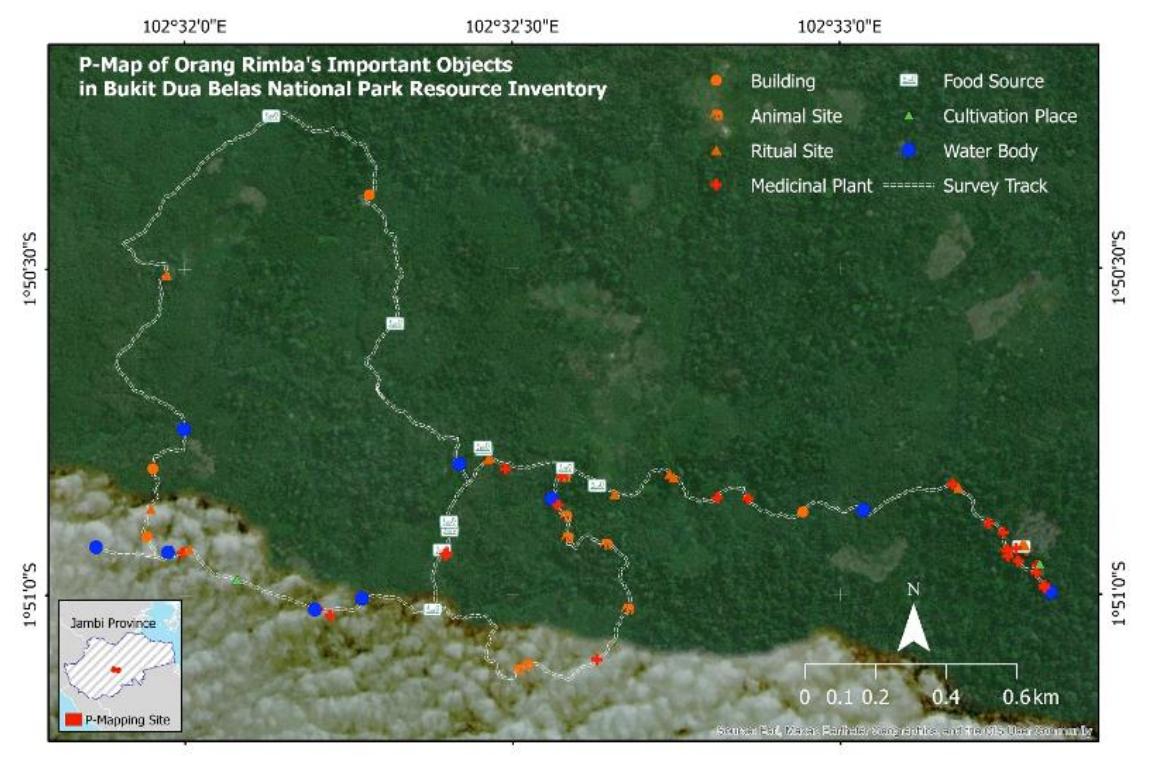
Figure 3. Point-of-interest map based on the PRM and GPS equipped transect survey with Orang Rimba.
To evaluate the spatial data produced, a final meeting was convened. This discussion offered an opportunity for the community to provide additional insight and feedback on the mapping team's findings. During this meeting, the community, including the traditional leader, the Temenggung, presented valuable supplementary information that was crucial for both the team and the researchers. This additional data included spatial information about the Orang Rimba's traditions, which are often overlooked even by community groups, particularly the younger generation. Moreover, information was unearthed regarding the medicinal properties of plants, their extraction methods, and their use in healing practices. Community leaders emphasized the significance of this mapping initiative as a step towards enabling the Orang Rimba to document their culture and sustainable relationship with the forest. Thus, future planning by both the community and the government must be aligned with the needs of indigenous peoples, who are currently facing increasing threats of deforestation and forest conversion for economic purposes. To ensure public accountability and facilitate widespread dissemination of the project's findings, the activity was documented in a short documentary film. This film is publicly available on the Youtube channel of the People's Planet Project (link: https://www.youtube.com/watch?v=V9lXvL9xSsk).
P-mapping with the Lavongai community in view of disaster issues
The project successfully enhanced spatial literacy within the Lavongai community through participatory GIS activities. Participants learned practical GIS skills and collaboratively mapped approximately 9 km² of Kaselok village using a combination of terrestrial surveys and GPS. A household survey was conducted to gather data on demographics, income sources, housing materials, water sources, and other relevant information. The survey revealed that the majority of households in Kaselok rely on fishing, agriculture, and small businesses for income. Most households have one income provider and an average of 3.7 dependents. The survey also
provided information on housing conditions and water sources. Woven bamboo walls with wooden supports were the predominant housing material, while dug wells were the primary source of water. Rainwater harvesting was also practiced by some households. The project observed coral bleaching along the Kaselok coastline, which has significant implications for local fishing practices. As noted, coral bleaching events are becoming more frequent and less dependent on El Niño events (Foale, 2002). The decline of Acropora corals has forced local communities to rely on less-preferred and slower-growing Porites corals (Wia et al., 2012), leading to a decline in fish populations and potential threats to food security.
The project also observed coastal recession, potentially caused by rising sea levels. While a quantitative evaluation of these changes was beyond the scope of this study, the observations highlight the vulnerability of the Lavongai community to climate change impacts. Highresolution satellite imagery analysis facilitated the identification of land-use categories within the study area. At least eight land-use types were distinguished within Kaselok village and a broader categorization encompassing fifteen types was established for the southern region of Lavongai Island. The primary concerns expressed by local residents centered on the environmental consequences of coastal hazards, particularly the potential loss of fishing grounds and fishponds. Additionally, there were concerns regarding the potential threat to coastal settlements. Building upon the land-use inventory and a sea level rise model (as presented in Figure 4), the analysis revealed that the coastal infrastructure in the southern part of Lavongai Island is projected to be significantly impacted by the simulated sea level rise scenario, including plantations and mangrove forests. This simple technique in p-mapping and GIS also underscores the substantial potential impact on infrastructure and emphasizes the urgent need for mitigation strategies.
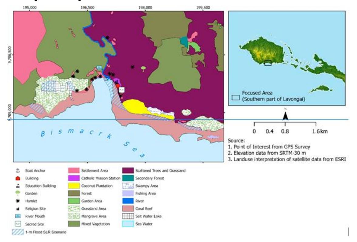
Figure 4. Extracted land use information and areas affected by projected sea level rise, acquired through p-mapping in the Lavongai community.
To conclude the workshop, a public discussion in a circle meeting setting (as can be seen in Figure 5a), was held along with gala dinner involving community leaders, local government officials, and representatives of community organizations, alongside a screening of documentary films produced by the film team. Participants of the GIS training presented their findings, including GPS surveys of settlement locations and water sources. Additionally, the team presented the results of land use mapping in the southern region and a disaster analysis of Lavongai Island in the context of a potential rise in sea level. During the session, community leaders, including religious leaders, offered positive feedback on the mapping team's success in extracting and visualizing community knowledge through map presentations (as depicted in Figure 5b). The symbols representing existing locations provided an overview of the development of the Lavongai region and highlighted the community's reliance on marine and forest resources. Furthermore, local leaders emphasized the importance of government support for community engagement, urging authorities to consider and incorporate community perspectives. A participatory planning approach, coupled with increased capacity building in geospatial technology, can be implemented at the local level to address environmental challenges, including climate change, which pose significant threats to small island communities. Further, all documentation presented YouTube (https://www.youtube.com/watch?v=IKgWgacLupE&t=162s).
Figure 5. Community meeting with the local community of Lavongai in a) circle setting, to evaluate the finding of p-mapping and b) gathering feedback from the stakeholders.
Discussion
Putting local spatial knowledge to work
As spatial knowledge emphasizes the importance of understanding the relationship between individuals, communities, and their environments, the current study aligns with the growing recognition of the value of indigenous spatial knowledge in addressing environmental challenges. Both case studies involved participatory mapping activities, tailored to the needs and skills of the respective communities. In both, basic GIS and remote sensing techniques were employed, allowing participants to process satellite imagery and GPS data from earlier training sessions, as highlighted by Paneque-Gálvez et al. (2017). In the Orang Rimba case, recent satellite images of Bangko from Google Earth were collected to enhance the participants' understanding of mapping and data collection. However, the primary focus was on developing terrestrial surveying skills and participatory resource mapping (PRM). Due to varying levels of technological literacy among participants, some adjustments were made, such as simplifying textual modules into video formats to match participants' familiarity with smartphones and mobile devices. A notable challenge during the fieldwork was the lower GPS accuracy under the dense vegetation canopy. To mitigate this, a buffer zone technique was applied and static methods were used to improve accuracy, as applied by Abdi et al. (2012). This approach demonstrates the powerful potential of spatial knowledge in empowering communities to address environmental challenges and advocate for sustainable solutions. By providing communities with the tools and knowledge to understand their environment and its risks, pmapping using GIS can play a critical role in building resilience and fostering sustainable development.
In the Lavongai case, the workshop also included GPS practice and technical guidance on terrestrial surveys, but the focus shifted to addressing disaster-related issues within the community, particularly the hazard and vulnerability aspects. The project applied p-mapping to empower the Lavongai community with spatial literacy and environmental management skills (Ioki et al., 2019; Mccall & Dunn, 2012). A multi-phased approach was implemented, with the first phase introducing GPS devices and ensuring the participants understood key concepts such as satellite connectivity and data accuracy (Putra Perdana & Ostermann, 2019; Widiyantoro et al., 2023). The second phase actively engaged the community, involving student-led social and economic surveys to gather data on environmental concerns such as coastal erosion and rising sea levels. This data was then used to create detailed maps of Kaselok village, incorporating demographic and water quality information. These maps served as a crucial foundation for understanding local environmental challenges and informed community advocacy efforts. By visualizing and analyzing spatial data, the community gained a deeper understanding of their vulnerabilities and could identify areas most at risk.
Both case studies demonstrate the application of p-mapping combined with GIS technology to empower communities in understanding and addressing environmental challenges. Key similarities include p-mapping activities, the use of GIS and remote sensing techniques, a focus on local knowledge, and the aim of addressing specific environmental issues. The use of spatial knowledge in these participatory planning processes serves several crucial purposes, as portrayed in Figure 6. First, p-mapping provides communities with the tools and knowledge to understand their environment and its risks, empowering them to participate more effectively in decision-making processes and advocate for their interests. Second, by visualizing and analyzing spatial data, communities gain a deeper understanding of environmental challenges and their impacts, leading to more informed and sustainable practices. Third, spatial data can be used to identify areas at risk from natural hazards or other environmental threats, helping communities develop early warning systems and implement mitigation measures. Fourth, pmapping can support communities in advocating for policies and actions that address environmental issues, as the visual evidence provided by maps can be a powerful tool for influencing decision-makers. Finally, by understanding their environment and its resources, communities can make more informed decisions about land use, resource management, and sustainable development. Ultimately, the use of spatial knowledge in participatory planning is a valuable approach for empowering communities, promoting environmental awareness, and supporting sustainable development. The case studies illustrate the effectiveness of p-mapping in addressing a range of environmental challenges.
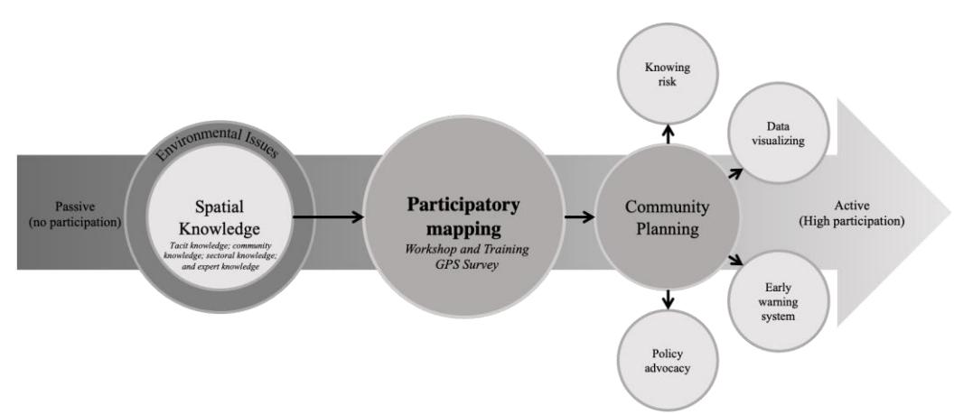
Figure 6. Empowering indigenous community through participatory mapping with GIS activity to address environmental issues.
Despite these similarities, there were notable differences in the focus and application of participatory mapping between the two case studies. The Orang Rimba project emphasized developing terrestrial surveying skills and rural mapping techniques with a focus on PRM, while the Lavongai project applied p-mapping to address disaster preparedness and environmental management. The technological literacy of the participants also varied between the two groups. The Orang Rimba participants had limited experience with computers but were familiar with smartphones, leading to adjustments in the training materials, whereas the Lavongai trainees were more focused on integrating GPS data into broader social and economic surveys. Furthermore, the Lavongai project placed greater emphasis on community-driven data collection and advocacy, exploring how GIS could empower the community to address pressing environmental challenges such as coastal erosion, which was less of a focus in the Orang Rimba case.
Spatial knowledge extraction and community planning
As spatial knowledge emphasizes the importance of understanding the relationship between individuals, communities, and their environments. The current study aligns with the growing recognition of the value of indigenous spatial knowledge in addressing environmental challenges. In Case 1, the study successfully employed a participatory mapping approach to engage young Orang Rimba community members in spatial data collection and analysis. The combination of indoor and outdoor activities, including GPS surveying and satellite imagery analysis, effectively introduced conventional mapping methods to the participants. While initial hesitation was observed, the mentors' supportive and engaging approach fostered greater interest and participation. The study aligns with previous research by Preto et al. (2016), Green et al. (2016), and Swords et al. (2019), which demonstrated the effectiveness of satellite imagery in enhancing environmental understanding among young people. By using transect walking with GPS technology, the Orang Rimba community was able to identify valuable natural resources within their territory, contributing to the protection of their land and cultural heritage. This study builds upon the work of Indrawan et al. (2019) and Syme (2020) by highlighting the importance of considering natural resources within forest communities and protecting indigenous rights. The transect walk approach has been proved to be accessible and informative for participants of varying educational backgrounds, as noted by Brown & Kyttä (2018). Furthermore, the indigenous group has endorsed the program's inception and proposed the following training, as outlined in multiple online meetings.
In the second case, the participatory mapping project in the Lavongai community emphasized the integration of spatial knowledge with modern data collection tools. The initial phase focused on demystifying GPS technology and fostering a sense of ownership among participants. The subsequent phases empowered students to take ownership of data collection and analysis. This study aligned with the UN's focus on programmatic approaches with sustained accompaniment (Kelman, 2014; Resurreccion et al., 2008), by addressing the specific vulnerabilities and priorities of the Lavongai community. The integration of local knowledge with scientific data collection methods, as highlighted by Nirwansyah et al. (2019); Suwarno et al. (2022), enriched the project's findings and informed future mitigation strategies (Islam et al., 2013; Kantamaneni et al., 2019). The community gathering provided a space for knowledge exchange and collaborative decision-making, aligning with Allen's (2006) framework for disaster preparedness. The project also equipped participants with GIS skills to evaluate information critically and participate in ongoing data collection efforts, addressing the call for strengthening capacities through community based disaster risk management (CBDRM) (Allen, 2006).
The study with the Orang Rimba and Lavongai case studies highlights the potential of participatory mapping to empower communities and support their efforts to address environmental challenges and at the same time support community planning. While both cases employed participatory mapping, the specific focus and approach differed significantly due to the unique environmental and social challenges faced by each community. The Orang Rimba community, with their focus on land use planning and natural resource management, required a more general-purpose mapping approach. In contrast, the Lavongai community, facing coastal erosion and disaster risks, needed a more specialized mapping approach to assess vulnerabilities and develop mitigation strategies. This underscores the importance of tailoring participatory mapping approaches to the specific needs and circumstances of each community. Beyond technical capacity building, the participatory mapping process fostered trust and collaboration within both communities. By combining local knowledge with scientific data, both projects created a platform for open dialogue among community members, researchers, and local leaders. The success of these initiatives highlights the crucial role of participatory GIS in promoting community-driven planning, environmental stewardship, and sustainable development.
The commitment of organizations like PPP, KMB, and AA to provide ongoing support is crucial for ensuring the long-term sustainability of participatory mapping initiatives. Such support can include technical assistance, funding, and capacity-building programs. In the Lavongai case, for example, future projects will focus on expanding skills related to mapping water resources and disaster mitigation, as well as providing legal support for environmental and community rights advocacy. By investing in these areas, organizations can help communities build on the foundations laid during the initial p-mapping workshops and continue to utilize spatial knowledge to address emerging environmental challenges. Participatory mapping, when informed by spatial knowledge and tailored to specific community needs, can be a powerful tool for empowering communities and addressing environmental challenges. By fostering collaboration, building trust, and promoting community-driven planning, p-mapping can contribute to more sustainable and resilient communities.
Conclusion
This study explored the potential of participatory mapping (p-mapping) in empowering indigenous communities to extract spatial knowledge and address environmental challenges. The participatory mapping projects with the Orang Rimba and Lavongai communities demonstrate the transformative potential of p-mapping in empowering indigenous groups to engage in collective planning and environmental monitoring activities. By combining traditional ecological knowledge with modern GIS technologies, both case studies effectively integrated spatial local knowledge with spatial technologies (GIS), enabling communities to visualize land use, environmental challenges, and resource distribution. The Orang Rimba project focused on developing terrestrial surveying and rural mapping skills to support sustainable land management, while the Lavongai initiative emphasized disaster preparedness and addressing coastal erosion and environmental degradation.
Despite the differences in focus, both projects highlight the importance of adapting participatory mapping methods to the unique cultural and environmental contexts of each community. The use of GIS and GPS provided participants with the tools to address their specific challenges, whether related to land use in the Orang Rimba's case or disaster mitigation in the Lavongai community. The success of these initiatives also underscores the critical role of ongoing support from organizations, ensuring that communities continue to develop the skills necessary for longterm resilience and advocacy. Finally, these participatory mapping efforts illustrate the functionalities of spatial knowledge in fostering collaboration, enhancing spatial literacy, and enabling community-driven solutions to complex social and environmental issues. By integrating scientific data with indigenous knowledge, these projects have laid the groundwork for sustainable development and environmental stewardship within the communities.
Acknowledgement
This project was partially funded by LPPM Universitas Muhammadiyah Purwokerto through the international research collaboration scheme under contract number A.11-III/7738- S.Pj./LPPM/II/2024. We extend our gratitude to the Orang Rimba community, particularly Kelompok Makekal Bersatu, the Sokola Institute in Jambi, and John Aini from Ailan Awareness, for their invaluable engagement and efforts in making this project possible. The authors also wish to thank the anonymous reviewers for their insightful suggestions and contributions.