
Abstrak.
Banjaran adalah wilayah sub urban di daerah vulkanik Cekungan Bandung Selatan yang mengalami perkembangan antropogenik secara dinamis. Disisi lain, variasi kondisi geologi di daerah penelitian berpengaruh pada interaksi batuan dan airtanah. Berdasarkan pada latar belakang tersebut, penelitian ini bertujuan untuk mengetahui pengaruh geologi dan lingkungan terhadap kondisi hidrokimia airtanah di daerah vulkanik. Metode yang digunakan adalah diagram piper, diagram Gibbs, korelasi dan bivariat ion utama. Pengambilan sampel airtanah sebanyak 23 sampel yang terdiri dari 10 sumur gali, 10 sumur bor dan 3 mata air. Hasil penelitian menunjukkan bahwa proses interaksi airtanah dipengaruhi oleh pelapukan batuan. Proses hidrogeokimia ion-ion utama di daerah vulkanik air tanah dicirikan oleh pelapukan silika. Fasies airtanah adalah CaMgCl, CaMgHCO3, NaHCO3. Proses hidrogeokimia ion-ion utama di daerah vulkanik air tanah dicirikan oleh pelapukan silika. Daerah hulu airtanah dipengaruhi oleh interaksi airtanah-batuan, sedangkan daerah hilir airtanah dipengaruhi oleh faktor antropogenik. Airtanah dangkal dengan tutupan lahan pertanian dan pemukiman lebih rentan terhadap pencemaran oleh aktivitas antropogenik. Kontrol struktural yang tinggi memungkinkan air mengalir melalui rekahan dan memudahkan proses pengenceran air tanah, sehingga membantu proses interaksi airtanah-batuan.
Kata kunci: Antropogenik, hidrogeokimia, interaksi airtanah-batuan, pelapukan batuan.
1. Introduction
Groundwater is essential to meet domestic, agricultural, livestock, and industrial needs (Luo, at al., 2018). Natural and anthropogenic environmental factors influence groundwater quality (Voutsis, at al., 2015). The hydrochemistry of groundwater is controlled by the interaction of water and rock involving minerals; besides that, anthropogenic processes from agriculture, domestic, and industry also affect the chemical quality of groundwater (Li, at al., 2013). Among anthropogenic activities, agricultural activities and fertilization most often cause a decrease in groundwater quality (Stellato, at al., 2020). Agricultural activities and active fertilization will increase nutrient concentrations in groundwater. Ammonium is very dangerous for humans because they interact with hemoglobin which inhibits the flow of oxygen into cells (methemoglobinemia) (Pastén, at al., 2014), forming nitrosamines as carcinogenic compounds (Chen, at al., 221). The natural factor affecting the volcanic aguifer is the high mineral dissolution process, which causes groundwater mineralization to be quite dominant (Aboubaker, at al., 2013). Hydrogeochemical data can describe hydrogeochemical processes that control groundwater quality, such as mineral dissolutiondeposition, ion exchange, and evaporation (Sosi, at al., 2019). The Banjaran sub-urban Area in the South Bandung Basin is a volcanic area with lithological variations and high anthropogenic activities. Based on this background, this study aims to analyze the influence of geology and the environment on the hydrogeochemical conditions of groundwater in volcanic areas. The analytical method used is the piper diagram, Gibbs diagram, correlation, and bivariate major ion. Major ion bivariate analysis will make it easier to understand the hydrogeochemical process of groundwater (Singh, at al., 2020). Statistical analysis of correlation and grouping will help understand the relationship between the major ion and other anthropogenic factors (Shi, at al., 2018).
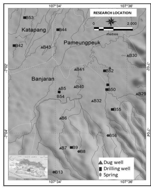
Figure 1. Research location in the Banjaran area
2. Study Area
This research was conducted in the southern part of Bandung Bansin, about 25 km south of Bandung City, West Java, by geographic location from 107°34' - 107°36' and - 7°04' - 7°02' (Figure 1). Banjaran area which includes Banjaran, Katapang and Pameungpeuk sub-districts located in Bandung Regency, West Java. This area has a morphology of undulating hills and lowlands; it has the potential to be developed for settlements.
3. Methodology
This research begins with a literature study followed by field investigations and laboratory analysis.
The study was conducted in the dry season. Groundwater data were collected from 10 dug wells, 10 drilled wells, and 3 springs. Physical properties of groundwater, including measurement of pH, conductivity, and temperature using a Horiba measuring instrument. All sampling is done at the research site. Laboratory analyzes were performed for major ions: Ca<sup>2+</sup>, Mg<sup>2</sup> Na<sup>+</sup>, K<sup>+</sup>, SO<sub>4</sub><sup>2-</sup>, Cl<sup>-</sup>, HCO<sub>3</sub><sup>-</sup>, CO<sub>3</sub><sup>-</sup>, NH<sub>4</sub>N, Fe, Mn. The analysis was carried out in the groundwater laboratory of the BRIN Research Center for Geotechnology. Analysis of Na<sup>+</sup> and K<sup>+</sup> used atomic absorption flame photometry (AAS) method, analysis of Ca<sup>2+</sup> and Mg<sup>2+</sup> ions using the complexometric method. The HCO3 analysis uses the acidimetric method, SO42 analysis uses the turbidimetric method, Cl- analysis uses the argentometry method, and TDS analysis uses the gravimetric method.
Physical and chemical hydrogeochemistry results from pH, EC, Ca<sup>2+</sup>, Mg<sup>2+</sup>, Na<sup>+</sup>, K<sup>+</sup>, SO<sub>4</sub><sup>2-</sup>, Cl<sup>-</sup>, and HCO<sub>3</sub> were processed by bivariate, multivariate, statistical, and spatial analysis. Statistical analysis of hydrogeochemical correlation was carried out to determine the relationship between groundwater quality parameters (Mallick, at al., 2018). Geostatistical analysis and correlation coefficient using the Pearson method (Mohamed, at al., 2019). Hierarchical group analysis was conducted to analyze homogeneous data by grouping data with similar properties based on the Physico-chemical properties of groundwater (Sosi, at al., 2019). Hydrochemical modeling was carried out using Groundwater Workbench software (GWB.2021) (Paternoster, at al., 2021). The results of the hydrogeochemical characterization as the basis for building a conceptual model of the hydrogeological system.
4. Data
Geological objects that are spatially distributed are Malabar volcanic deposits (Qmt) and lake deposits (Qd) (Alzwar, at al., 1992). The distribution of groundwater resources is located in the surrounding of The Malabar volcano (Qmt), with an altitude ranging from 756 - 858 m. Springs are strategic resources widely used for the fulfillment of raw water. The youngest rock unit at the study site is a Holocene-old lake deposit (Qd), consisting of loose material the size
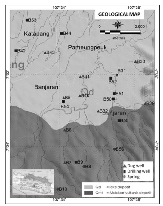
Figure 2. Geological map in the Banjaran area (modification from Geological Map of the Garut and Pameungpeuk Quadrangle, Java, 1992 )
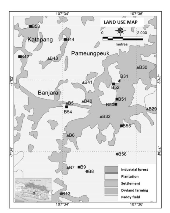
Figure 3. The land use in the Banjaran sub urban area
Table 1. The summary of the physico-chemical properties in the research area
| Dug well | Drilling well | Spring | ||||||||
|---|---|---|---|---|---|---|---|---|---|---|
| Min | Max | Mean | Min | Max | Mean | Min | Max | Mean | ||
| pH | 5.25 | 7.90 | 6.88 | 6.61 | 7.77 | 7.45 | 6.10 | 7.46 | 6.74 | |
| Temp (oC) | 25.10 | 28.60 | 26.50 | 28.20 | 33.00 | 29.43 | 26.30 | 28.80 | 27.20 | |
| EC (µS/cm) | 15.00 | 430.00 | 279.50 | 50.00 | 460.00 | 312.00 | 60.00 | 120.00 | 86.67 | |
| TDS (mg/L) | 58.00 | 260.00 | 170.40 | 56.00 | 372.00 | 227.60 | 22.00 | 136.00 | 91.33 | |
| Na+ (mg/L) | 3.65 | 26.68 | 13.05 | 1.31 | 43.18 | 21.80 | 2.03 | 7.69 | 4.54 | |
| + K (mg/L) | 0.50 | 11.79 | 3.47 | 0.68 | 8.59 | 4.40 | 0.38 | 0.68 | 0.50 | |
| Mg2+(mg/L) | 3.64 | 25.21 | 11.12 | 1.20 | 21.09 | 10.60 | 2.31 | 5.19 | 3.29 | |
| Ca2+(mg/L) | 2.87 | 52.48 | 32.10 | 5.01 | 42.26 | 22.28 | 2.77 | 7.93 | 5.67 | |
| Cl- (mg/L) | 6.89 | 46.83 | 25.58 | 5.26 | 53.76 | 17.89 | 6.77 | 22.04 | 12.61 | |
| - SO4 (mg/L) | 4.12 | 49.52 | 19.77 | 4.64 | 8.34 | 5.43 | 5.10 | 10.59 | 7.59 | |
| - HCO3 (mg/L) | 12.18 | 216.09 | 119.71 | 13.08 | 258.25 | 150.70 | 9.45 | 21.35 | 16.42 | |
| Mn(mg/L) | 0.01 | 1.45 | 0.43 | 0.01 | 0.81 | 0.28 | 0.01 | 0.01 | 0.01 | |
| Fe(mg/L) | 0.01 | 4.53 | 0.96 | 0.01 | 6.56 | 1.71 | 0.01 | 0.05 | 0.03 | |
| NH4N(mg/L) | 0.06 | 2.52 | 0.73 | 0.09 | 6.46 | 2.67 | 0.02 | 0.11 | 0.07 | |
of clay, silt, sand, and gravel that is tuffaceous. Malabar volcanic deposits (Qmt) consist of basalt lava and andesite basalt. The basalt lava flow is grey-black and has a very fine aphanitic to the porphyritic glass structure. Phenocryst consists of plagioclase and pyroxene. Basal andesite is dark grey, has a fine aphanitic porphyry texture, and phenocrysts consisting of plagioclase and pyroxene embedded in an aphanitic bed mass (Figure 2).
The characteristics of volcanic areas are based on geological conditions, sedimentary structures, and biology (Bronto, 2006). The research area has medial and distal volcanic facies. The medial facies is located on the lower slope, and the distal facies is located on the plains of the lake deposits (Maria, at al., 2021).
The Banjaran area uses plantations, settlements, dry land agriculture, and rice fields (Figure 3). The point of sampling location for springs, especially in settlements, plantations, and rice fields. The land use pattern in the study area affects the hydrogeochemical conditions of the study area. Domestic, animal husbandry, and agricultural activities affect the concentration of the primary ion elements (Esteller, et al., 2016). In other areas, residues from agricultural activities are a source of pollution from ammonium (H. R. V., et al., 2011).
5. Results and Discussion
The hydrogeochemical spatial modeling shows the distribution pattern of hydrogeochemical variations. Physico-chemical properties from field data collection and chemical properties are taken from the laboratory (Table 1). In general, the major cations is in the range of \(Ca^{2+} > Mg^{2+} > Na^{+} > K^{+}\) and the major anions \(HCO_{3}^{-} > Cl^{-} > SO_{4}^{-}\). The concentration of \(Ca^{2+}\) in dug wells ranged from 2.87 - 52.48 mg/L, in drilling wells ranged from 5.01- 42.26 mg/L, and in springs ranged from 2.77-7.93 mg/L. Mg<sup>2+</sup> content in dug wells ranged from 3.64-25.21mg/L, in drilling wells ranged from 1.20-21.09mg/L, and in springs, it ranged from 2.31-5.19 mg/L. The concentration of Na<sup>+</sup> in dug wells ranged from 3.65-26.68mg/L, in drilling wells ranged from 1.31-43.18mg/L, and in springs ranged from 2.03 -7.69mg/L. The K<sup>+</sup> content in dug wells ranged from 0.50 - 11.79 mg/L, in drilling wells ranged from 0.68-8.59 mg/L, and in springs, it ranged from 0.38 - 0.68 mg/L. Cl concentrations in dug wells ranged from 6.89 - 46.83 mg/L; in bore wells, they ranged from 5.26-53.76 mg/L; and in springs, they ranged from 6.77 - 22.04 mg/L. The SO<sub>4</sub> content in dug wells ranged from 4.12 - 49.52 mg/L. In drilling wells, it ranged from 4.64 - 8.34 mg/L, and in springs, it ranged from 5.10 - 10.59 mg/L. The concentration of HCO<sub>3</sub> in dug wells ranged from 12.18 - 216.09 mg/L, in drilling wells ranged from 13.08 - 258.25 mg/L, and in springs, it ranged from 9.45 - 21.35 mg/L. The concentration of Mn in dug wells ranged from 0.01 -1.45 mg/L. In drilling wells, it ranged from 0.01 - 0.81 mg/L, and in springs, it ranged from 0.01 - 0.01mg/L. The concentration of Fe in dug wells ranged from 0.01 - 4.53 mg/L; in drilling wells, it ranged from 0.01 -6.56 mg/L; in springs, it ranged from 0.01 - 0.05 mg/L. The NH<sub>4</sub>N content in dug wells ranged from 0.06 -2.52 mg/L; in drilling wells, it ranged from 0.09 - 6.46 mg/L, and in springs, it ranged from 0.02 - 0.11 mg/L.
The concentration of the major ion in drilling wells is relatively higher than in dug wells and springs; this is influenced by the journey and time of groundwater transport. The spring has a relatively lower elemental concentration because it is close to the recharge site, so the groundwater has not been in contact for too long with rock minerals. Ca<sup>2+</sup> and Mg<sup>2+</sup> cations are alkaline earth metals, essential elements in igneous minerals (Dedzo, et al., 2017). The increase in concentration occurs naturally due to traveling through sedimentary rock layers through which groundwater passes (Gnanachandrasamy, et al., 2015). The concentration of Cl<sup>-</sup> anion comes from the influence of hydrothermal activities around the springs. The concentration of HCO<sub>3</sub><sup>-</sup> ions in groundwater sources indicates that groundwater comes from local meteoric (Hem, 1985).
The Pearson correlation on groundwater in the Banjaran area is (Table 2): pH value has a moderate correlation with EC, TDS, Na<sup>+</sup>, and HCO<sub>3</sub><sup>-</sup>. Electrical conductivity (EC) strongly correlates with TDS, Na<sup>+</sup>, Ca<sup>2+</sup>, HCO<sub>3</sub><sup>-</sup>, moderately correlated with pH, Ca<sup>2+</sup>, Cl<sup>-</sup>, HCO<sub>3</sub><sup>-</sup> dan NH<sub>4</sub>N. TDS strongly correlates with EC, Na<sup>+</sup>, moderately correlated with pH, Ca<sup>2+</sup>, Cl<sup>-</sup>, HCO<sub>3</sub><sup>-</sup>, and NH<sub>4</sub>N. Sodium (Na<sup>+</sup>) strongly correlates with EC, TDS, and NH<sub>4</sub>N, with moderate correlation with pH, HCO<sub>3</sub><sup>-</sup> and Cl-. Potassium (K<sup>+</sup>) correlates moderately with EC, Ca<sup>2+</sup>, HCO<sub>3</sub><sup>-</sup>, Mn, and NH<sub>4</sub>N. Calcium (Ca<sup>2+</sup>) is strongly correlated with EC, HCO<sub>3</sub><sup>-</sup>, moderately correlated with TDS, Mg<sup>2+</sup>, K<sup>+</sup>, HCO<sub>3</sub><sup>-</sup> and NH<sub>4</sub>N.
Magnesium (Mg<sup>2+</sup>) strongly correlated with HCO<sub>3</sub> moderately correlated with EC, Ca<sup>2+</sup>, Fe, and Mn. Chloride (Cl<sup>-</sup>) is moderately correlated with Na<sup>+</sup> and Ca<sup>2+</sup>. Bicarbonate (HCO<sub>3</sub><sup>-</sup>) is strongly correlated with EC, Ca<sup>2+</sup>, Mg<sup>2+</sup>, and NH<sub>4</sub>N and moderately correlated with pH, TDS, Na<sup>+</sup>, K<sup>+</sup>, and Fe. Manganese (Mn) is moderately correlated with HCO<sub>3</sub><sup>-</sup>, Mg<sup>2+</sup>, and Fe, and Iron (Fe) is moderately correlated with HCO<sub>3</sub><sup>-</sup>, Mg<sup>2+</sup> and Mn. Ammonium (NH<sub>4</sub>N) strongly correlates with Na<sup>+</sup>, HCO<sub>3</sub><sup>-</sup>, and moderately correlated with EC, TDS, K<sup>+</sup>, Mn, and Fe. High values of TDS, EC, Fe, SO<sub>4</sub><sup>2-</sup>, Cl<sup>-</sup> and NH<sub>4</sub>N are seen in distal zones. Based on field investigations and laboratory analysis, the presence of SO<sub>4</sub><sup>2-</sup>, Cl<sup>-</sup> and NH<sub>4</sub>N comes from environmental pollution from nature and the influence of human activities such as fertilizers, households, and agriculture.
Groundwater in each region has different characteristics (Esteller, et al., 2016). a Piper diagram analysis was carried out to determine the characteristics of the groundwater (Güler, et al., 2002).
Table 2. Pearson correlation on groundwater in the Banjaran area
| рН | EC | TDS | Na⁺ | K⁺ | Mg2+ | Ca2+ | CI- | SO42- | HCO3 | Mn | Fe | NH4N | |
|---|---|---|---|---|---|---|---|---|---|---|---|---|---|
| рН | 1 | ||||||||||||
| EC | 0.66 | 1 | |||||||||||
| TDS | 0.63 | 0.78 | 1 | ||||||||||
| Na⁺ | 0.52 | 0.72 | 0.82 | 1 | |||||||||
| \(K^{+}\) | 0.49 | 0.66 | 0.41 | 0.41 | 1 | ||||||||
| Mg2+ | 0.27 | 0.65 | 0.39 | 0.39 | 0.44 | 1 | |||||||
| Ca2+ | 0.45 | 0.84 | 0.54 | 0.35 | 0.60 | 0.57 | 1 | ||||||
| Cl | 0.05 | 0.44 | 0.43 | 0.50 | 0.15 | 0.14 | 0.39 | 1 | |||||
| SO42- | 0.19 | 0.24 | 0.01 | -0.06 | 0.03 | 0.13 | 0.44 | 0.31 | 1 | ||||
| HCO3 | 0.56 | 0.87 | 0.65 | 0.59 | 0.66 | 0.78 | 0.76 | 0.07 | -0.01 | 1 | |||
| Mn | 0.09 | 0.35 | 0.28 | 0.13 | 0.42 | 0.59 | 0.47 | -0.04 | -0.12 | 0.59 | 1 | ||
| Fe | 0.24 | 0.44 | 0.32 | 0.29 | 0.45 | 0.56 | 0.35 | -0.02 | -0.27 | 0.61 | 0.66 | 1 | |
| NH4N | 0.48 | 0.69 | 0.64 | 0.73 | 0.61 | 0.43 | 0.31 | 0.10 | -0.38 | 0.73 | 0.27 | 0.53 | 1 |
220 Jurnal Teknik Sipil
Based on the piper diagram analysis, it is known that the groundwater facies are CaMgCl, CaHCO<sub>3</sub> and NaHCO<sub>3</sub> (Figure 4). The CaMgCl facies is a spring on the slopes of a lower volcano that Mg<sup>2+</sup> cations have enriched in the interaction process of groundwater and rock.
Calcium-magnesium concentrations result from weathering of Ca<sup>2+</sup>-rich silica minerals from basaltic andesite volcanic rocks. The dominance of Cl concentration comes from hydrothermal lateralization in the upstream mountains and anthropogenic activities. The CaHCO<sub>3</sub> facies group is groundwater influenced by local meteoric water, which indicates that groundwater circulation is not too far away. The dominant Ca<sup>2+</sup> concentration is due to interactions with volcanic rocks. The concentration of HCO<sub>3</sub> ions indicates that groundwater has mixed with shallow groundwater as local recharge. The NaHCO<sub>3</sub> facies is groundwater with substantial anthropogenic influence in the distal facies area. The source of Na<sup>+</sup> cations and HCO<sub>3</sub> anions comes from weathering volcanic deposits compositions of Na-feldspar, K-feldspar, pyroxene, and olivine. The HCO<sub>3</sub> ion concentration indicates that groundwater from local recharge has a meteoric origin.
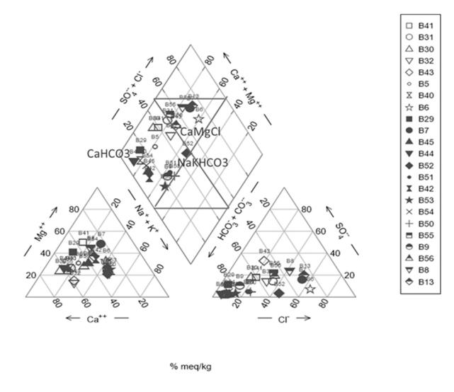
Figure 4. Piper diagram in Banjaran Area
The interaction of rock and water is generally seen in dissolving groundwater and rock, including chemical and physical reactions (Morán, et al., 2016). The interaction of rock and water can be evaluated by plotting \((Ca^{2+} + Mg^{2+})\) and \((HCO_3^- + SO_4^{2-})\). The results of bivariate \((Ca^{2+} + Mg^{2+})\) and \((HCO_3^- + SO_4^{2-})\)showed the hydrogeochemical process of major ions in groundwater volcanic regions is characterized by silica weathering (Figure 5). The Ca<sup>2+</sup> and Mg<sup>2</sup> cations are alkaline earth metals and essential elements in igneous minerals. Concentration increasingly occurs naturally due to traveling through sedimentary rock layers through which groundwater passes.
Hydrogeochemical processes in groundwater control the mechanism of groundwater originating from rainwater, rock weathering, crystallization, or evaporation (Okiongbo
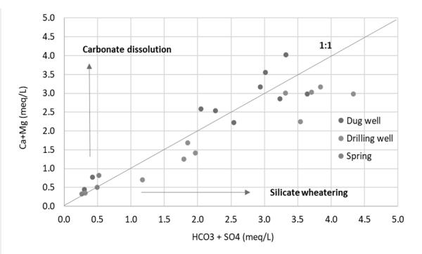
Figure 5. Bivariate (\(Ca^{2+} + Mg^{2+}\)) and (\(HCO_3^- + SO_4^{2-}\)).
and Douglas, 2015). One of the methods used is the Gibbs Diagram which can distinguish between the interaction effects of rock weathering, evaporation, and the impact of rainwater on the chemical processes of groundwater (Xiong, et al., 2020).
In the Gibbs diagram of groundwater based on the ratio of anion TDS to Cl<sup>-</sup> / (Cl<sup>-</sup> + HCO<sub>3</sub><sup>-</sup>), the study area shows that groundwater is dominantly influenced by rock weathering. In contrast, in some places, it is affected by rainwater (Figure 6a). Based on the comparison of TDS anion with \((Na^++K^+)\) / \((Na^++K^++Ca^{2^+})\), it shows that groundwater is dominantly influenced by weathering of rocks and, in some places, influenced by rainwater (Figure 6b). Groundwater affected by rock weathering is located in Qmt formation in the proximal and medial facies. Groundwater affected by rainwater is located in lake deposits (Qd) in the distal facies.
TDS shows the concentration of ions dissolved in water; the greater the value is directly proportional to
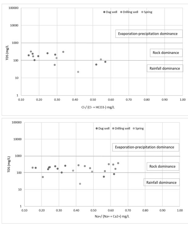
Figure 6. The gibbs diagram
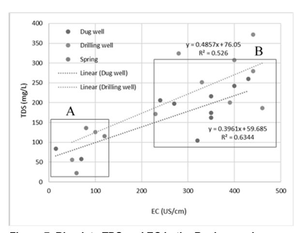
Figure 7. Bivariate TDS and EC in the Banjaran urban area
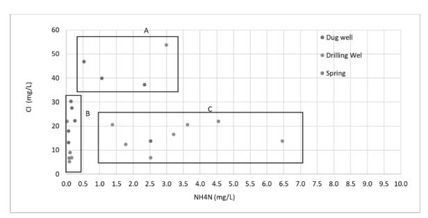
Figure 8. Bivariate Cl<sup>-</sup> and NH<sub>4</sub>N
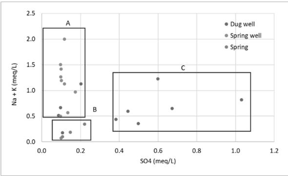
Figure 9. Bivariate SO<sub>4</sub>2- and (Na+K+)
the dissolved ion (Effendi, 2013). TDS and EC come from environmental conditions such as natural conditions and the influence of human activities such as households, industry, and agriculture (Rusydi, 2018). The relationship between the major ion and TDS shows the hydrogeological processes in the aquifer system (Wu, et al., 2015). The value of TDS indicates the travel time of groundwater (Kehew, 2001). Areas with low TDS have a shorter contact time with rocks, so they can be indicated as a recharge area (Maria, et al., 2021).
In the bivariate analysis of TDS and EC, there were 2 groups of groundwater. Group A is groundwater with a low value of TDS and EC. This group is located in a proximal area with short groundwater interaction times and is close to the recharge area. Group A is distributed in Malabar volcanic deposits (Qmt) and has a high fracture control that allows the groundwater dilution process, thus helping the rock-water interaction. Group B is a high value of TDS and EC; this group is located in a medial-distal area with long groundwater interaction times and many interaction processes with rocks, indicating the discharge area. The positive correlation between the EC and TDS shows groundwater's hydrogeological processes and travel time; it can be indicated as a recharge area.
Anthropogenic influence groundwater on hydrogeochemistry is seen from the aspect of Cl., \(SO_4^2\)and NH<sub>4</sub>N concentrations (Figure 8). Agricultural activities will produce fertilizer residues, increasing the ion value for Cl<sup>-</sup>, NH<sub>4</sub>N, SO<sub>4</sub><sup>2-</sup>, and (Na<sup>+</sup> +K<sup>+</sup>) (Pawar and Shaikh, 1995). Various anthropogenic activities such as plantation agricultural fertilizers, livestock, and domestic waste will affect groundwater quality (Deka, et al., 2015). The bivariate analysis of Cl<sup>-</sup> and NH<sub>4</sub>N showed there were 3 groups of groundwater. Group A is groundwater with a high value of Cl but a low value of NH<sub>4</sub>N, located in a proximal area with short groundwater interaction times. The high concentration comes from volcanic activity. Group B is groundwater with a low value of Cl and NH4N, indicating the recently occurring interaction process between groundwater and rock. This area can also be called the recharge area. The land use pattern in the upstream area is dominated by agriculture and, plantations, animal husbandry, while the downstream area is densely populated, affecting groundwater quality. Group C has a low value of Cl but a high-value NH<sub>4</sub>N. The high NH<sub>4</sub>N concentration comes from anthropogenic activity, agricultural residues, and livestock. High NH4N concentrations occur in the rainy season due to mineral dissolution and accumulation in the distal area with lake deposits (Qd).
Anthropogenic effects can be evaluated by plotting Cl and NH<sub>4</sub>N. The bivariate Cl and NH<sub>4</sub>N showed three groups (Figure 8). Group A is groundwater with high Cl and NH<sub>4</sub>N values, located in a medial area. Group B is groundwater with low Cl and NH<sub>4</sub>N values, located in a proximal area, and Group C is groundwater with low Cl value but high NH<sub>4</sub>N values, located in a distal area. Hydrothermal and water-rock interactions influence high Cl values, and high NH<sub>4</sub>N values are influenced by anthropogenic activities such as livestock, manure, agricultural fertilizers, and domestic waste.
Bivariate SO<sub>4</sub><sup>2-</sup> and (Na<sup>+</sup> + K<sup>+</sup>) showed three groups (Figure 9). Group A is groundwater with high (Na<sup>+</sup> + K<sup>+</sup>) but low SO<sub>4</sub><sup>2-</sup> values, distributed in the medial facies of Malabar volcanic deposits (Qmt). Group B is groundwater with low SO<sub>4</sub><sup>2-</sup> and (Na<sup>+</sup> +K<sup>+</sup>) values, distributed in the proximal Malabar volcanic deposits (Qmt). Group C is groundwater with low (Na<sup>+</sup> +K<sup>+</sup>) but high SO<sub>4</sub><sup>2-</sup> values, distributed in the distal facies lake deposits (Qd) (Figure 9). High (Na<sup>+</sup> +K<sup>+</sup>) values are influenced by rock water interactions. High SO<sub>4</sub><sup>2-</sup> agricultural activities influence values. Groundwater upstream area dominated influenced by the groundwater-rock interaction, while anthropogenic
factors influence groundwater downstream area. Shallow groundwater with land covering agricultural and settlements is more susceptible to contamination by anthropogenic activities. Prevailing geological structure conditions such as rock fractures allow water to flow and facilitate the dilution of groundwater, thus helping the process of rock-water interaction.
6. Conclusion
Based on the results of the analysis, the following conclusions were obtained ;
- 1. The hydrogeochemical process of major ions in groundwater volcanic regions is characterized by weathering of silica. The highest weathering effect of silica minerals in the distal facies results in the enrichment of Ca2+, Mg2+, and HCO3 ions.
- 2. Groundwater has a high enough HCO3 ratio which shows rock weathering as a significant factor, weathering minerals rich in calcium and magnesium.
- 3. Groundwater upstream area dominated influenced by the groundwater-rock interaction, while anthropogenic factors influence groundwater downstream area.
- 4. Shallow groundwater with land covering agricultural and settlements is more susceptible to contamination by anthropogenic activities.
- 5. High structural control allows water to flow through the fracture and facilitates the groundwater dilution process, thus helping the process of rock-water interaction.
7. Acknowledgments
The author would like to thanks the Saintek Scholarship Program of the Ministry of Research and Technology, which has funded the education program. Thanks, are also given to the Head of the Research Center for Geotechnology, Indonesian Institute of Science, Dr. Eko Yulianto, who has given permission for providing laboratory facilities to carry out the water sample analysis. Mr. Dady Sukmayadi, and Mr. Wahyu Purwoko have helped a lot in laboratory analysis.
References
- A. F. Rusydi, "Correlation between conductivity and total dissolved solid in various type of water: A review," IOP Conf. Ser. Earth Environ. Sci., vol. 118, no. 1, pp. 0–6, 2018, doi: 10.1088/1755- 1315/118/1/012019.
- A. K. Mohamed, L. Dan, S. Kai, M. A. A. Mohamed, E. Aldaw, and B. A. Elubid, "Hydrochemical analysis and fuzzy logic method for evaluation of groundwater quality in the North Chengdu plain, China," Int. J. Environ. Res. Public Health, vol. 16, no. 3, 2019, doi: 10.3390/ijerph16030302.
- B. Sosi, A. Getabu, S. Maobe, and J. Barongo, "Relationship Between Aquifer Processes and Groundwater
- Quality: A Case of Olbanita Aquifer System, Lower Baringo Basin, Kenya Rift," Air, Soil Water Res., vol. 12, 2019, doi: 10.1177/1178622119889910.
- C. Güler, G. D. Thyne, J. E. McCray, and A. K. Turner, "Evaluation of graphical and multivariate statistical methods for classification of water chemistry data," Hydrogeol. J., vol. 10, no. 4, pp. 455–474, 2002, doi: 10.1007/s10040-002-0196-6.
- E. Pastén-Zapata, R. Ledesma-Ruiz, T. Harter, A. I. Ramírez, and J. Mahlknecht, "Assessment of sources and fate of nitrate in shallow groundwater of an agricultural area by using a multi-tracer approach," Sci. Total Environ., vol. 470–471, pp. 855–864, 2014, doi: 10.1016/ j.scitotenv.2013.10.043.
- G. Gnanachandrasamy, T. Ramkumar, S. Venkatramanan, S. Vasudevan, S. Y. Chung, and M. Bagyaraj, "Accessing groundwater quality in lower part of Nagapattinam district, Southern India: using hydrogeochemistry and GIS interpolation techniques," Appl. Water Sci., vol. 5, no. 1, pp. 39–55, 2015, doi: 10.1007/s13201-014-0172-z.
- G.Y. Xiong, et al., "A comparative study on hydrochemical evolution and quality of groundwater in coastal areas of Thailand and Bangladesh," J. Asian Earth Sci., vol. 195, no. November 2019, p. 104336, 2020, doi: 10.1016/ j.jseaes.2020.104336.
- H. Effendi, Telaah Kualitas Air. Kanisius Yogyakarta, 2013.
- H. R. V. and V. O. F. Hugo Ernesto Flores López, Celia De La Mora Orozco, Álvaro Agustín Chávez Durán, José Ariel Ruiz Corral, "Nonpoint Pollution Caused by the Agriculture and Livestock Activities on Surface Water in the Highlands of Jalisco, Mexico," Intech, p. 13, 2012, [Online]. Available: http://dx.doi.org/ 10.1039/C7RA00172J%0Ahttps://www.intechopen. com/books/advanced-biometric-technologies/ liveness-detection-in-biometrics%0Ahttp://dx. doi.org/10.1016/j.colsurfa.2011.12.014.
- H. Wu, J. Chen, H. Qian, and X. Zhang, "Chemical Characteristics and Quality Assessment of Groundwater of Exploited Aquifers in Beijiao Water Source of Yinchuan, China: A Case Study for Drinking, Irrigation, and Industrial Purposes," J. Chem., vol. 2015, 2015, doi: 10.1155/2015/726340.
- J. D. Hem, "Study and interpretation of the chemical characteristics of natural water.," US Geol. Surv. Water-Supply Pap., vol. 2254, 1985.
- J. Mallick et al., "Hydro-geochemical assessment of groundwater quality in Aseer Region, Saudi Arabia," Water (Switzerland), vol. 10, no. 12, pp. 1–14, 2018, doi: 10.3390/w10121847.
- J. Morán-Ramírez, R. Ledesma-Ruiz, J. Mahlknecht, and J. A. Ramos-Leal, "Rock-water interactions and pollution processes in the volcanic aquifer system of Guadalajara, Mexico, using inverse geochemical modeling," Appl. Geochemistry, vol. 68, no. March, pp. 79–94, 2016, doi: 10.1016/j.apgeochem.2016.03.008.
- J. P. Deka, G. Tayeng, S. Singh, R. R. Hoque, A. Prakash, and M. Kumar, "Source and seasonal variation in the major ion chemistry of two eastern Himalayan high altitude lakes, India," Arab. J. Geosci., vol. 8, no. 12, pp. 10597–10610, 2015, doi: 10.1007/s12517-015-1964-7.
- K. S. Okiongbo and R. K. Douglas, "Evaluation of major factors influencing the geochemistry of groundwater using graphical and multivariate statistical methods in Yenagoa city, Southern Nigeria," Appl. Water Sci., vol. 5, no. 1, pp. 27– 37, 2015, doi: 10.1007/s13201-014-0166-x.
- Kehew AE, Applied chemical hydrogeology. New jersey: Prentice hall, 2001.
- L. Stellato et al., "Natural and anthropogenic groundwater contamination in a coastal volcanicsedimentary aquifer: The case of the archaeological site of cumae (phlegraean fields, southern italy)," Water (Switzerland), vol. 12, no. 12, pp. 1–24, 2020, doi: 10.3390/ w12123463.
- M. Aboubaker, M. Jalludin, and M. Razack, "Hydrochemistry of a complex volcano-sedimentary aquifer using major ions and environmental isotopes data: Dalha basalts aquifer, southwest of Republic of Djibouti," Environ. Earth Sci., vol. 70, no. 7, pp. 3335–3349, 2013, doi: 10.1007/s12665-013 -2398-8.
- M. Alzwar, N. Akbar, and S. Bachri, "Geological Map of the Garut and Pameungpeuk Quadrangle, Java," 1992.
- M. G. Dedzo, D. Tsozué, M. E. Mimba, F. Teddy, R. M. Nembungwe, and S. Linida, "Importance of rocks and their weathering products on groundwater quality in central-east Cameroon," Hydrology, vol. 4, no. 2, 2017, doi: 10.3390/hydrology4020023.
- M. Paternoster et al., "Hydrogeochemistry and Groundwater Quality Assessment in the High Agri Valley (Southern Italy)," Geofluids, vol. 2021, 2021, doi: 10.1155/2021/6664164.
- M. V. Esteller, N. Kondratenko, J. L. Expósito, M. Medina, and M. A. Martin del Campo, "Hydrogeochemical characteristics of a volcanic-sedimentary aquifer with special emphasis on Fe and Mn content: A case study in Mexico," J. Geochemical Explor., vol. 180, no. October 2016, pp. 113–126, 2017, doi: 10.1016/j.gexplo.2017.06.002.
- N. J. Pawar and I. J. Shaikh, "Nitrate pollution of ground waters from shallow basaltic aquifers, Deccan Trap Hydrologic Province, India," Environ. Geol., vol. 25, no. 3, pp. 197–204, 1995, doi: 10.1007/BF00768549.
- N. Voutsis, E. Kelepertzis, E. Tziritis, and A. Kelepertsis, "Assessing the hydrogeochemistry of groundwaters in ophiolite areas of Euboea Island, Greece, using multivariate statistical methods," J. Geochemical Explor., vol. 159, pp. 79–92, 2015, doi: 10.1016/ j.gexplo.2015.08.007.
- P. Li, H. Qian, J. Wu, Y. Zhang, and H. Zhang, "Chemismus der Hauptionen im flachen Grundwasser im Kohlefeld Dongsheng, Ordos Becken, China," Mine Water Environ., vol. 32, no. 3, pp. 195–206, 2013, doi: 10.1007/s10230- 013-0234-8.
- R. Maria et al., "Groundwater recharge area based on hydrochemical and environmental isotopes analysis in the south bandung volcanic area," Indones. J. Chem., vol. 21, no. 3, pp. 609–625, 2021, doi: 10.22146/ijc.58633.
- S. Bronto, "Fasies gunung api dan aplikasinya," Indones. J. Geosci., vol. 1, no. 2, pp. 59–71, 2006, doi: 10.17014/ijog.vol1no2.20061.
- Singh, A. K. Patel, J. P. Deka, and M. Kumar, "Natural recharge transcends anthropogenic forcing that influences arsenic vulnerability of the quaternary alluviums of the Mid-Gangetic Plain," npj Clean Water, vol. 3, no. 1, pp. 1–12, 2020, doi: 10.1038/s41545-020-0075-5.
- W. Luo, X. Gao, and X. Zhang, "Geochemical processes controlling the groundwater chemistry and fluoride contamination in the yuncheng basin, China an area with complex hydrogeochemical conditions," PLoS One, vol. 13, no. 7, pp. 1–25, 2018, doi: 10.1371/journal.pone.0199082.
- X. Shi, Y. Wang, J. J. Jiao, J. Zhong, H. Wen, and R. Dong, "Assessing major factors affecting shallow groundwater geochemical evolution in a highly urbanized coastal area of Shenzhen City, China," J. Geochemical Explor., vol. 184, no. October, pp. 17–27, 2018, doi: 10.1016/ j.gexplo.2017.10.003.
Maria at al.
Y. Chen et al., "Occurrence of N-nitrosamines and their precursors in the middle and lower reaches of Yangtze River water," Environ. Res., vol. 195, no. January, 2021, doi: 10.1016/ j.envres.2020.110673.