
Abstrak
Metode iRAP Star Rating dan Inspeksi Keselamatan Jalan (IKJ) memiliki tujuan yang sama untuk meningkatkan keselamatan jalan tetapi dengan pendekatan yang berbeda. Penelitian ini memanfaatkan iRAP Star Rating untuk menyaring segmen jalan yang memerlukan analisis lebih detail menggunakan IKJ pada ruas jalan Kopo – Soreang, yaitu segmen jalan dengan Star Rating kurang dari 3. Hasil penilaian iRAP Star Rating menunjukkan bahwa masih terdapat segmen jalan dengan nilai Star Rating dibawah 3 untuk seluruh pengguna jalan, dengan estimasi fatalitas sebanyak 58 kejadian dalam satu tahun. Dengan metode SR4RSA, rekomendasi penanganan keselamatan dari metode iRAP Star Rating disesuaikan dengan metode IKJ sehingga didapatkan 28 rekomendasi penanganan yang dapat diterapkan pada ruas jalan Kopo – Soreang, sehingga menghasilkan segmen-segmen dengan Star Rating minimal 3 untuk seluruh pengguna jalan dengan estimasi pengurangan fatalitas sebanyak 49,91%. Setelah penanganan, jumlah segmen yang memiliki Star Rating 5 untuk pengguna kendaraan penumpang lebih banyak dibanding Star Rating untuk pengguna jalan lainnya. Hal ini mengindikasikan rekomendasi penanganan yang diterapkan lebih berorientasi pada keselamatan pengguna kendaraan penumpang.
Kata Kunci: IKJ, iRAP Star Rating, SR4RSA
1. Introduction
The issue of road traffic and transportation safety has become a global problem that the world has to face. Globally, road traffic crashes cause nearly 1,3 million preventable deaths and an estimated 50 million injuries each year – making it the leading killer of children and young people worldwide (World Health Organization, 2021). Aware of the importance of this issue and the need for immediate action, governments from around the world, through the adoption of the 2020 UN General Assembly resolution A/RES/74/299 on "Improving Global Road Safety" set a target to reduce at least 50% roadtraffic deaths and serious injuries by 2030 as stated in the Global Plan Decade of Action for Road Safety2021-2030.
In response to the Global Plan Decade of Action for Road Safety 2021-2030, Indonesia issued Presidential Regulation No. 1 of 2022 Concerning "Rencana Umum Nasional Keselamatan Lalu Lintas Dan Angkutan Jalan" (RUNK LLAJ). RUNK LLAJ is stipulated for 20 (twenty) years from 2021 to 2040 to reduce the fatality index of road crashes using the2010 database. The national RUNK LLAJ program is based on a 5 (five) pillar approach. One of the efforts in supporting safety for road users is to createsafer roads, as stated in Pillar-2 Safer Roads. The goal of Pillar-2 is that technical safety standards are met for all road users, and more than 75% of motorized vehicles travel on existing roads that meetstandard of Star Rating 3 (three).
The Star Rating standard can be adopted with the iRAP (International Road Assessment Programme) methodology. iRAP is a road assessment program developed by an international organization in road safety. The WHO has standardized it to assess the safety condition of road sections with quantified assessment in the form of a Star Rating. In Indonesia, the iRAP method has yet to be widely used as a road safety condition assessment. Indonesia's most common road safety condition assessment is the Road Safety Inspection (RSI). Road Safety Inspection is a Road Safety Audit undertaken on a road in service (existing roads). However, the Road Safety Inspection method cannot issue an assessment in the form of a Star Rating.
The Road Safety Inspection and iRAP methodology have the same goal to reduce the risk of crashes and fatalities on a road section, but they have different approaches. Road Safety Inspection has a systematic, formal approach and a detailed examination by an independent team of qualified auditors. The iRAP methodology, on the other hand, is an internationally standardized method where the process uses data and physical evidence that results in a quantified safety measurement in the form of a Star Rating. Therefore, This study aims to assess the safety condition of road sections using the SR4RSA method, which by combining the iRAP Star Rating and RSI methodology will produce a safety condition assessment that is suitable for Indonesian conditions and can answer the objective of RUNK LLAJ in supporting the Global Plan Decade of Action for Road Safety 2021-2030.
2. Literature Review
iRAP is a road assessment program developed by an international organization in road safety. iRAP uses road attributes data formed into coding to generate a Star Rating value. Road attributes are parts of the road that can be in the form of road infrastructure conditions or road geometric conditions. Observations of road attributes for existing roads areobtained through road condition surveys based on the iRAP Survey Manual. There are 78 road attributes that must be recorded in the form of coding, with the coding process for each attribute referring to the iRAP Coding Manual Drive on the Left Edition. This research uses Star Rating for Design (SR4D) to process road attributes coding to generate Star Rating. SR4D available on the ViDA website (http://vida.irap.org)
with a working manualbased on the ViDA User Guide and the Star Rating for Design (SR4D) Web App User Guide. iRAP Star Rating involves examining road attributes that are known to have an impact on crash likelihood and severities, whereas roads that have higher crash likelihood and severities are rated as Star Rating 1 and 2. In contrast, roads that have lower crash likelihood and severities are rated as Star Rating 4 and 5. There are four types of Star Rating issued by iRAP according to road users: vehicle occupants, motorcyclists, bicyclists, and pedestrians.
In addition to the Star Rating value, Fatality and Serious Injuries (FSI) Estimation and Safer Road Investment Plan (SRIP) can be determined by the iRAP methodology. FSI estimation is used to estimate the number of fatalities and serious injuriesthat occur on road sections. Meanwhile, the SRIP is used for economic analysis in selecting countermeasures. This stage refers to the iRAP Star Rating and Investment Plan Manual. After determining existing Star Rating, countermeasures can be determined to increase existing Star Rating toachieve Star Rating value of 3 and above. Based on iRAP Methodology Fact Sheet #11 Countermeasures, there are 94 recommended countermeasures that can be used to achieve Star Rating value of 3 and above.
(Smith et al., 2022) explained that the Star Rating for Road Safety Audit (SR4RSA) methodology has presented practical ways that can be used to combinethe iRAP Star Rating and Road Safety Inspection methodology. Central Asia Regional Economic Cooperation (CAREC) issued a manual that can be used for SR4RSA implementation practices entitled CAREC Road Safety Engineering Manual 5: Star Ratings for Road Safety Audit. There are 3 fundamental approaches for SR4RSA. This research uses SR4RSA Level 2 which is this approach adds production of Star Ratings for the length of thedesign, with and without RSI recommendations. In general, the assessment using SR4RSA Level 2 determines the existing Star Rating using iRAP methodology and then road segments with Star Rating below 3 will be subjected to Road Safety Inspection. The implementation of Road Safety Inspection (RSI) is based on the Guide to RoadSafety Audit Part 6: Road Safety Audit issued by Austroads in 2022. The RSI is implemented by determining the safety concerns on the road section and risk assessment, and then determining of the recommended countermeasures are based on the hierarchy of control. In addition, Austroads also provides a prompt list that can be used to assist auditors in determining safety concerns on road sections. Countermeasures from RSI method are adjusted to countermeasures series from iRAP method to get Star Rating after countermeasures.
There are several previous studies that review the use of iRAP in Indonesia. (Hadi, 2015) explains the relationship between the Road Protection Score (RPS) value and the identification of dangerous locations where the most dangerous locations are not at the highest RPS value. In addition, (Tobing, 2015) explained the relationship between crash rates and
Road Protection Score (RPS) values where changes in crash rates did not follow changes in RPS values. From these two studies, it can be concluded that the results from iRAP methodology has not been able to describe the safety conditions on road sections in Indonesia. 2015) compared countermeasures based on the iRAP methodology and RSI methodology where recommendations from the iRAP methodology cannot be used as a reference for detailed recommended countermeasures. (Setyarini & Lie, 2022) also compared the use of iRAP and RSI methodology in evaluating the safety conditions of road sections where each method has its advantages and disadvantages. From these two studies, it can be concluded that the iRAP and RSI methodology cannot be compared because the approaches are different, so there is a need for a study that combines these two methods in assessing safety conditions on road sections.
3. Methodology
The study was conducted on Kopo - Soreang provincial road (10,14 km) in Bandung, West Java as shown in Figure 1. The crash and fatality data forthis road section was obtained for 3-years period from 2020-2022. A total of 71 crashes and 25 fatalities were recorded in this road section.
Requirement data for this research was obtained by conducting the primary survey and secondarysurvey. The primary data needed were road conditions (inventory and geometrics), road environmental conditions, observed flow and peak hour flow, operational speed, and Average Daily Traffic (ADT). At the same time, the secondary data needed was crash data sourced from the West Java Regional Police. Road condition data, observed flowand peak hour flow, operational speed and ADT were observed per 100-meter road segment and formed into an iRAP coding. iRAP describes the coding options for each attribute listed in order of highest to lowest risk. For each attribute, code the 'worst' case category every 100meter road segment.
Star Rating is calculated from Star Rating Score based on iRAP coding using SR4D on ViDA online platform per 100-meter road segment for all road users (vehicle occupant, motorcyclists, bicyclists, and pedestrian). Initial Star Rating is used to filter road segments with
Figure 1. Location of study
Star Rating values below 3. In addition, crash data is used to determine road segments where crashes have occurred. If road segments meet one of the criteria (rated Star Rating below 3 or being crash location), then that road segments needs a Road Safety Inspection (RSI).
Road Safety Induction was conducted by determining the safety concerns on the road section and risk assessment, and then determining of the recommended countermeasures. The recommended countermeasures from RSI methodology were adjusted with the list of countermeasures provided by iRAP methodology. In addition, it is necessary to consider the countermeasures that can be applied to the road conditions and the driver behaviour of Indonesian road users. countermeasures from RSI and iRAP methodology were inputted back into SR4D to determine Star Rating aftercountermeasures where to answer the objectives of the RUNK LLAJ and the Global Plan Decade of Action for Road Safety 2021-2030, the minimum Star Rating value after countermeasures needs to be rated at 3 stars or above. In addition, FSI estimation before and after countermeasures was analyzed to determine how much reduction in fatality and serious injuries occurred after countermeasures. Theroad safety condition assessment results were made in the SR4RSA format level 2 approach.
4. Results and Discussions
4.1 Initial star rating
Segmentation of road sections was carried out per 100 m with the help of a walking meter and GPS Map Camera for recording coordinates. The total number of segments for the Kopo - Soreang road section is 110 segments. The results of the road condition survey of road attributes and the processing of speed and ADT data per 100 m of road segment were coded in .csv (comma-separated values) format following the iRAP Upload File Specification, which will be uploaded in SR4D on the ViDA website.
Two types of Star Rating are generated by the iRAP methodology, namely, Raw Star Rating and Smoothed Star Rating. Raw Star Rating is a Star Rating based on the actual Star Rating Score value per 100 m road segment, while Smoothed Star Rating is the result of smoothing (average) the Star Rating Score value along a particular road segment. The purpose of the Smoothed Star Rating is to simplify the Star Rating value. This research only reviews the Star Rating Raw value to get Star Rating value of 3 and above. Table 1 shows each road user's
Table 1. Length of segment with certain star rating value
| Star | Segment Length (km) | |||||
|---|---|---|---|---|---|---|
| Rating | Vehicle Occupant | Motorcyclists | Bicyclists | Pedestrian | ||
| 5 | 5 | 0,9 | 0 | 0 | ||
| 4 | 2,5 | 5,3 | 1,7 | 1,1 | ||
| 3 | 2,2 | 3,3 | 5,9 | 3,8 | ||
| 2 | 0,4 | 0,4 | 1,7 | 3,4 | ||
| 1 | 1 | 1,2 | 1,8 | 1,8 | ||
existing Star Rating values. Based on the existing Star Rating values, there are still road segments with Star Rating values below 3 for all road users.
4.2 Road Safety Inspection
Road Safety Inspections are conducted on road segments that meet one of the requirements of having a Star Rating value below 3 or being a crash location. Crash location determined from traffic crashes data analysis. Based on traffic crashes data from the West Java Regional Police from 2020 - 2022 on the Kopo - Soreang road section, 71 crashes occurred. Traffic crashes data analysis is conducted based on three categories, namely, based on the severity of the victim, based on the road users involved, and based on the type of collision that occurred, as shown in Figure 2, 3, and 4.
Based on the severity of the victim, traffic crashes that occurred were dominated by minor crashes and the number of casualties due to traffic crashes was less than 100 during 3-year period. Road users involved in traffic crashes were dominated by motorcyclists with the common type of collision thatoccurred was head-on collision. This analysis will be used in determining recommended countermeasuresfor the road section.
The traffic crash data does not give information about the exact location of the crash location. Therefore, determining
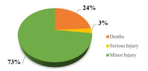
Figure 2. Traffic crash data based on severityof the victim
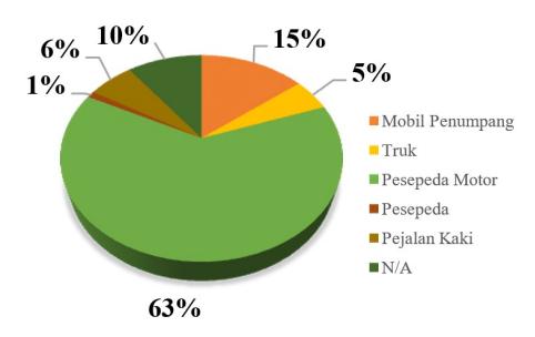
Figure 3. Traffic crash based on road users involved
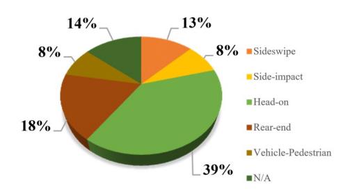
Figure 4. Traffic crash based on type of collision
crash locations is based on the segmentation per 100 m road segment that has been conducted. Table 2 shows the segmentgrouping with total traffic crashes and total casualties based on each crash locations. The highest total crashes and highest total casualties are located at segments 9 – 14. Segments 53 – 56 also have hightotal casualties. Each segment group has an averagevalue of Star Rating Score so the Star Rating of each segment group can be determined.
Table 3 shows that segments 9 – 14 and segments 53 – 56 have a good Star Rating values for all road users despite these segments having a high number of crashes and casualties. Segments 29 – 31 show a Star Rating value of 1 for all road users but have a low number of crashes and casualties. In contrast to segment 32 – 35 that show a Star Rating value of 1 for all road users as well and the number of crashes and casualties can be considered quite high. It can be concluded that a low Star Rating value does not necessarily have a high number of crashes and casualties, Star Rating only shows how much safety protection that road can give to road users in preventing fatalities due to crashes so it cannot be compared to the number of crashes or casualties.
Table 2. Total traffic crashes and total casualties
| Segment Group | Total Crashes | Total Casualties |
|---|---|---|
| 1 - 6 | 3 | 4 |
| 9 – 14 | 9 | 11 |
| 15 – 21 | 4 | 8 |
| 22 – 25 | 4 | 4 |
| 29 – 31 | 4 | 4 |
| 32 – 35 | 6 | 10 |
| 38 – 42 | 5 | 6 |
| 43 – 48 | 6 | 8 |
| 53 – 56 | 6 | 11 |
| 57 – 63 | 6 | 8 |
| 66 – 69 | 6 | 8 |
| 72 – 75 | 5 | 7 |
| 76 – 81 | 4 | 3 |
| 82 – 91 | 3 | 4 |
Table 3. Star rating each segment group
| Star Rating | ||||
|---|---|---|---|---|
| Segment Group | Vehicle | Occupant Motorcyclists Bicyclists Pedestrian | ||
| 1 - 6 | 3 | 3 | 2 | 1 |
| 9 – 14 | 4 | 3 | 3 | 2 |
| 15 – 21 | 3 | 3 | 2 | 1 |
| 22 – 25 | 4 | 3 | 2 | 1 |
| 29 – 31 | 1 | 1 | 1 | 1 |
| 32 – 35 | 1 | 1 | 1 | 1 |
| 38 – 42 | 2 | 1 | 1 | 1 |
| 43 – 48 | 3 | 2 | 1 | 2 |
| 53 – 56 | 4 | 4 | 3 | 3 |
| 57 – 63 | 4 | 4 | 3 | 1 |
| 66 – 69 | 5 | 4 | 3 | 3 |
| 72 – 75 | 4 | 4 | 3 | 3 |
| 76 – 81 | 3 | 3 | 2 | 2 |
| 82 – 91 | 4 | 4 | 3 | 1 |
Table 4 shows the collision type that occurred in each segment group. This data is used as additional information in the RSI implementation process in determining the safety concerns that cause thesecollision types to occur in each road segment group.There are 5 collision types that commonly occur on Kopo – Soreang road section which are head-on collisions, rear-end collisions, sideswipe collisions, side-impact collisions, and vehicle – pedestrian collisions.
Table 5 shows the road segments that require Road Safety Inspections. The total number of segments for which Road Safety Inspections should be conductedis 90 out of 110 total segments (81.82%). Road Safety Inspections will be performed on all segments of the Kopo - Soreang road section by paying particular attention to the 90 segments that meet the requirements.
Road Safety Inspection is carried out along the Kopo - Soreang road section by giving additional attentionto 90 segments of road sections that meet the requirements of rated Star Rating below 3 and road segments that have been a crash location. The implementation of Road Safety Inspection is carriedout by finding safety concerns that exist on the Kopo - Soreang road section.
The safety concerns found from the Road Safety Inspection along the Kopo - Soreang road section were
Table 4. Collision type each segment group
| Segment Group | Collision Type |
|---|---|
| 1 - 6 | Head-on Rear-end |
| 9 – 14 | Head-on Rear-end Sideswipe Side-impact Vehicle-Pedestrian Collision |
| 15 – 21 | Head-on Rear-end |
| 22 – 25 | Head-on Rear-end |
| 29 – 31 | Rear-end Sideswipe Side-impact |
| 32 – 35 | Rear-end Vehicle-Pedestrian Collision |
| 38 – 42 | Head-on Side-impact Vehicle-Pedestrian Collision |
| 43 – 48 | Head-on Rear-end Side-impact |
| 53 – 56 | Head-on Vehicle-Pedestrian Collision |
| 57 – 63 | Head-on Rear-end |
| 66 – 69 | Head-on Rear-end Sideswipe Side-impact |
| 72 – 75 | Head-on Side-impact |
| 76 – 81 | Head-on Sideswipe Vehicle-Pedestrian Collision |
| 82 – 91 | Head-on Rear-end |
Table 5. Road segment criteria for RSI implementation
| Segment | Rated Star Rating Below 3 | Crash Location |
|---|---|---|
| 0 – 6, 9 – 25, 29 – 35, 38 – 43, 45, 48, 56 – 57, 60 – 61, 66 – 69, 79 – 81, 88 – 91 | Yes | Yes |
| 44, 46 – 47, 53 – 55, 58 – 59, 62 – 63, 66 – 69, 72 – 78, 82 – 87 | No | Yes |
| 7 – 8, 26 – 28, 36 – 37, 49 – 50, 92 – 94, 99, 102 | Yes | No |
| 51 – 52, 64 – 65, 70 – 71, 95 – 98, 100 – 101, 103 – 110 | No | No |
inadequate delineation of signs, markings, and lighting, inadequate intersection facilities, hazardous object that located on clear zones, pavement surfaces defects, defects on bridges structure and pavement, inadequate sight distance on curve, inadequate facilities for vulnerable road users such as sidewalks and zebra crossings, and inadequate facilities in high pedestrian activity areas such as schools, markets, factories, and hospitals. Based on these safety concerns, 16 recommended countermeasure wereproduced, which are:
- 1. Create line markings delineation and replace faded/old line markings on road sections and intersections;
- 2. Eliminate or relocate hazardous object out of clear zones;
- 3. Provide delineation on hazardous object that cannot be removed or relocated;
- 4. Provide sidewalks for pedestrians and tighten regulations on sidewalks activity such as prohibiting merchant activities on sidewalks and vehicle parking;
- 5. Provide sign delineation on dangerous locationalong road sections such as high pedestrian activity areas, curves, intersections, and repair existing signs ;
- 6. Repair facilities of signalized intersection that are not functioning correctly and add intersection channelization;
- 7. Create drainage ditch cover that can be used as shoulder or sidewalks or provide fences that are compliant with standards and continuously equipped with end terminal treatment;
- 8. Repair surface road defects and skid resistance by doing rehabilitation of road surfaces;
- 9. Duplicate bridge by building a new bridge as the existing bridge is approaching its planned life;
- 10. Repair damaged street lighting and add street lighting in areas that lack of lighting;
- 11. Provide school zone facilities such as Safe School zone signs and markings, and provide supervisor or crossing guard during school hours;
- 12. Provide signs and marking at areas of high pedestrian activity such as markets, industries, and hospital;
- 13. Eliminate objects that obstruct visibility on curve sight distance, intersection visibility, and signs visibility;
- 14. Provide crossing facilities at points of high pedestrian crossing activities;
- 15. Provide centreline rumble strips and shoulder rumble strips that can be used as a warning for drivers that leaving lane;
- 16. Provide other delineation facilities to help driver's vision at night, such as road studs.
4.3 Selection of countermeasures
The recommended countermeasures from the Road Safety Inspection were adjusted to the 94 countermeasure lists available from the iRAPmethodology. The adjustments results are shown in Table 6.
The adjustment of the RSI methodology recommended countermeasures with the countermeasures list from iRAP methodology resulted in 28 recommneded countermeasures asfollows:
- 1. Improve Delineation;
- 2. Improve Curve Delineation;
- 3. Delineation And Signing (Intersection);
- 4. Clear Roadside Hazards Passenger Side;
Table 6. Adjustment of RSI countermeasures with iRAP countermeasures
| countermeasures | |
|---|---|
| RSI Countermeasure No | iRAP Countermeasures |
| 1 | Improve Delineation Improve Curve Delineation Delineation and Signing(Intersection) |
| 2 | Clear Roadside Hazards – PassengerSide Clear Roadside Hazards – DriverSide |
| 3 | Improve Delineation |
| 4 | Footpath Provisions Passenger Side (Adjacent to Road) Footpath Provisions Driver Side (Adjacent to Road) Parking Improvements |
| 5 | Improve Delineation Improve Curve Delineation Delineation and Signing (Intersection) |
| 6 | Upgrade Pedestrian Facility Quality Signalised Crossing Side Road Signalised CrossingSight Distance (Obstruction Removal) |
| 7 | Shoulder Sealing Passenger Side(>1m) Shoulder Sealing Driver Side (>1m) Roadside Barriers – Passenger Side |
| 8 | Road Surface Rehabilitation Skid Resistance (Paved Road) |
| 9 | No suitable iRAP Countermeasure |
| 10 | Street Lighting (Mid-Block) Street Lighting (Intersection) Street Lighting (Ped Crossing) |
| 11 | School Zone Warning – Signs andMarkings School Zone – Crossing Guard orSupervisor |
| 12 | Improve Delineation Traffic Calming/Speed Management |
| 13 | Sight Distance (Obstruction Removal) |
| 14 | Unsignalised Crossing Side Road Unsignalised Crossing Unsignalised Raised Crossing Upgrade Pedestrian Facility Quality |
| 15 | Centreline Flexi-Post/Centreline Rumble Strips Shoulder Rumble Strips |
| 16 | Improve Delineation |
- 5. Clear Roadside Hazards Driver Side;
- 6. Footpath Provision Passenger Side (AdjacentTo Road);
- 7. Footpath Provision Driver Side (Adjacent To Road);
- 8. Parking Improvements;
- 9. Upgrade Pedestrian Facility Quality;
- 10. Signalised Crossing;
- 11. Side Road Signalised Pedestrian Crossing;
- 12. Sight Distance (Obstruction Removal);
- 13. Shoulder Sealing Passenger Side (>1m);
- 14. Shoulder Sealing Driver Side (>1m);
- 15. Roadside Barriers Passenger Side;
- 16. Road Surface Rehabilitation;
- 17. Skid Resistance (Paved Road);
- 18. Street Lighting (Mid-Block);
- 19. Street Lighting (Intersection);
- 20. Street Lighting (Ped Crossing);
- 21. School Zone Warning Signs And Markings;
- 22. School Zone Crossing Guard Or Supervisor;
- 23. Traffic Calming;
- 24. Unsignalised Crossing;
- 25. Side Road Unsignalised Pedestrian Crossing;
- 26. Unsignalised Raised Crossing;
- 27. Centreline Flexi-Post/Centreline RumbleStrips;
- 28. Shoulder Rumble Strips.
4.4 Star rating after countermeasure
The results of the adjustment of the 28 recommended countermeasures were inputted back into SR4D on the ViDA website by changing the coding in the .csv file that had been created. For example, for theCentreline Rumble Strips treatment, the coding waschanged from "1 - Not Present" to "2 - Present". After the coding was changed, the .csv file was uploaded again in SR4D to see the Star Rating after the implementation of the Countermeasures. Table 7 shows the Star Rating values before and after the implementation of the countermeasures for the Kopo - Soreang road section.
Based on the table, it can be concluded that the Star Rating value after implementing the countermeasure resulting a Star Rating value of 3 and above for all road users. In addition, the value of a Star Rating 5 on vehicle occupant is higher than other road users. This indicates that the recommended countermeasures are oriented toward only vehicle occupant's safety. The selection of recommended countermeasures should consider other road users bybalancing Star Rating value for all road users.
4.5 FSI before and after countermeasures
FSI Estimation is a value that describes theprobability of a crash on a road section that can result in fatalities and serious injuries for one year. Table 8 shows the existing FSI Estimation for the Kopo - Soreang road section.
Table 7. Star rating before and after countermeasures
| Road Length With | Vehicle Occupant | Motorcyclists | Bicyclists | Pedestrian | ||||
|---|---|---|---|---|---|---|---|---|
| Star Rating | Before | After | Before | After | Before | After | Before | After |
| 5 | 5 km | 7,9 km | 0,9 km | 1,3 km | 0 | 0,1 km | 0 | 0,9 km |
| 4 | 2,5 km | 2,1 km | 5,3 km | 8,1 km | 1,7 km | 8,6 km | 1,1 | 6,4 km |
| 3 | 2,2 km | 1,1 km | 3,3 km | 1,7 km | 5,9 km | 2,4 km | 3,8 | 3,8 km |
| 2 | 0,4 km | 0 | 0,4 km | 0 | 1,7 km | 0 | 3,4 | 0 |
| 1 | 1 km | 0 | 1,2 km | 0 | 1,8 km | 0 | 2,8 | 0 |
In one year, the total FSI Estimation for the Kopo - Soreang road section is 58.1, which means that if there are no applied countermeasures, there will be 58 possible crashes resulting in fatalities and serious injuries.
Table 9 show that the total FSI Estimation generatedafter the implementation of the countermeasures is 29.1, which can be concluded that the implementation of the
Table 8. Existing FSI estimation Kopo –Soreang road section
| Vehicle Occupant | Motorcyclists | Bicyclists | Pedestrian | Total |
|---|---|---|---|---|
| 1,7 | 24 | 20,9 | 11,4 | 58,1 |
Table 9. FSI estimation after countermeasures
| Vehicle Occupan | Motorcyclists | Bicyclists | Pedestrian | Total |
|---|---|---|---|---|
| 1,1 | 14,5 | 8,4 | 5,1 | 29,1 |
countermeasures can reduce by 49.91% the number of fatalities and serious injuries caused by traffic crashes in one year.
4.6 Road safety assessment with SR4RSA level 2
The results of assessing road safety conditions with the SR4RSA methodology combine safety concerns, risk assessment, and recommended countermeasures from the RSI methodology with Star Rating values before and after implementation of countermeasuresfrom the iRAP methodology into one table. In this research, the SR4RSA approach level used is level 2, where the Star Rating value listed in the table is the Star Rating value for the entire Kopo - Soreang road section. Table 10 shows an example of the road safety condition assessment results using the SR4RSA level 2 methodology.
After assessing the safety conditions using the SR4RSA level 2 method, the advantages and disadvantages
Table 10. Example road safety assessment using SR4RSA level 2
| Safety Concerns | Risk | Existing Star Rating | Recommendation | Star Rating After Countermeasures |
|---|---|---|---|---|
| There is no centreline delineation markings and edge line delineation markings along road section, and the existing | Very | Provide centreline and edge line delineation markings, provide rumble strips, and repair | ||
| delineation line markings are not maintained properly | High | existing delineation line markings |
Table 11. Comparison of Irap and SR4RSA level 2 methodology
| iRAP | SR4RSA Level 2 | |
|---|---|---|
| Input | Road attributescondition defined by coding | Road attributescondition defined bycoding |
| Process | iRAP Coding, Input parameter for FatalityEstimation, and Investment Plan | Finding existing Star Rating using iRAP methodology to filter road segments with a Star Rating value below 3 for the implementations of RSI, recommended countermeasures from RSI are adjusted to iRAP recommendation to get Star Rating 3 and above |
| Output | Star Rating, FSI Estimation and Countermeasures | Star Rating, FSI Estimation, Safety Concern, Risk Assessment and Countermeasures |
| Advantages | Can generate economic analysis for the countermeasures selected | Recommended countermeasures have been adjusted to road condition and driver behaviour, recommendation based on all safety concern recorded, and Star Rating after countermeasures can be adjusted to produce Star Rating value of 3 and above |
| Disadvantages | Countermeasures obtained may not suitable to road conditions and driver behaviour, and Star Rating produced may not necessarily resulted in Star Rating value of 3 and above | Level 2 approach cannot produce economic analysis for countermeasures selected, but with level 3 approach, an economic analysis can be produced but with higher data requirements and higher qualifications |
of each road safety condition assessment methodology can be compared. Table 11 shows the differences between the iRAP and SR4RSA level 2 methodology and the advantages and disadvantages of each method.
5. Conclusions
- 1. Star Rating only shows how much safety protection that road can give to road users in preventing fatalities due to crashes so it cannotbe compared to the number of crashes or casualties;
- 2. Road safety condition assessment using Star Rating for Road Safety Audit methodology stilluses aspects of subjectivity so that the assessment results will differ depending on thesubjectivity of each person;
- 3. The results of the selected countermeasures are still oriented towards the safety of vehicle occupants, it should be noted that countermeasures selection should consider the safety of all road users so that the Star Rating value after countermeasures are balanced for all road users;
- 4. From this research, it can be concluded that the assessment results of the road safety conditions of the Kopo - Soreang road section based on the Star Rating for Road Safety Audit Level 2 approach methodology resulted in 28 recommendations for countermeasures that can be applied to the Kopo - Soreang road section resulting in road segments with a minimum Star Rating of 3 for all road users and a reduction in fatality estimation value of 49,91% so that it has answered the objectives of the "Rencana Umum Nasional KeselamatanLalu Lintas dan Angkutan Jalan" and the Global Plan Decade of Action for Road Safety2021-2030.