
Abstrak
Perubahan tata guna lahan di Sub-DAS Tanralili Kabupate Maros Provinsi Sulawesi Selatan berdampak signifikan terhadap dinamika hidrologi, dimana meningkatan limpasan permukaan dan mempecepat periode debit banjir puncak. Sebagian besar lahannya 75,51%, dialifungsikan menjadi pertanian lahan kering campuran dan sawah, dengan menyisakan 24,49% untuk hutan lahan kering sekunder, hutan tanaman industri, semak belukar, vegetasi pada rumput dan tanah terbuka, sehingga lahan ini menjadi kritis. Penelitian ini mengkaji kinerja Lubang Resap Biopori (BAH) dalam mengurangi risiko banjir dengan meningkatkan infiltrasi dan mengurangi limpasan. Eksperimen dilakukan pada tanah dengan permeabilitas sedang (0,00178 cm/s), memanfaatkan unit BAH PVC berukuran diameter 10 cm dan panjang 100 cm, dengan biopori ÿ10 mm. BAH ditempatkan pada tiga titik pada lahan pertanian lahan kering campuran, semak belukar, dan tanah terbuka. BAH ini ditempatkan pada lereng 0,23% dan diuji di bawah berbagai intensitas curah hujan (I2, I5, I10). Menggunakan persamaan Mononobe untuk limpasan permukaan, debit puncak dengan HSS Nakayasu. Hasilnya menunjukkan penurunan debit banjir puncak sebesar 58,80% dan peningkatan infiltrasi sebesar 62,99%. Temuan menunjukkan potensi BAH sebagai solusi ramah lingkungan untuk mitigasi banjir.
Kata Kunci: Limpasan permukaan, laju infiltrasi, debit banjir puncak, kinerja lubang resap biopori.
1. Introduction
The Tanralili sub-watershed Maros Regency, South Sulawesi Province, which covers an area of 278.39 km², is a watershed management that does not pay attention to land conservation. The region is largely characterized by mixed dryland agriculture (68.33%), rice fields (7.11%), and a combination of dryland
forest, shrubland, and grassland (23.95%). However, unsustainable land use, characterized by land-use expansion and economic priorities, has led to significant environmental degradation. These changes have resulted in reduced groundwater supply for river flows during the dry season, increased flood peaks during the rainy season, and disruptions in the hydrological cycle. Increased surface runoff and
* Penulis Korespondensi: amrullah.mansida@unismuh.ac.id
decreased infiltration rates further disrupt groundwater recharge, a critical factor in maintaining water availability throughout the year. Addressing these challenges requires the implementation of sustainable strategies that align economic development with ecological conservation.
Research shows that the interaction of land use patterns and watershed sustainability, indicating that land use changes substantially increase surface runoff, increase peak flood discharges, and reduce water availability due to reduced infiltration and groundwater recharge (Mansida et al., 2021); (Zema et al., 2022). Expansion of agricultural activities and urbanization further exacerbate groundwater contamination and deplete water resources in affected areas (Choi and Kim, 2022). Empirical studies reveal a strong correlation between land use changes and groundwater pollution indices, underscoring the cascading effects on ecosystem integrity (Nyakundi, Nyadawa and Mwangi, 2022). Increased surface runoff decreases infiltration rates, which in turn reduces groundwater recharge and increases the risk of flooding, disrupting watershed balance (Fernández-Nóvoa et al., 2022) (Shaikh et al., 2023). These findings underscore the urgent need for sustainable land management strategies to mitigate adverse impacts and restore watershed stability in a sustainable manner.
Mitigating the adverse impacts of land use change on watersheds (DAS) requires the implementation of flood management strategies aimed at reducing surface runoff and increasing infiltration. Effective approaches include increasing vegetation cover, increasing soil absorption capacity, and implementing infiltration wells (Alzboon, La'aly and Alrawashdeh, 2021). The working principle of biopori absorption holes is to store and absorb rainwater into the hole and seep it into the soil as infiltration water(Hidayat et al., 2021). Among these strategies, Biopore Absorption Holes (BAH) have emerged as a promising nature-based solution, facilitating water infiltration, minimizing runoff, and supporting groundwater conservation by channeling water directly into the soil (Azizi, Ilderomi and Noori, 2021)(Fathurrahman and Surya, 2024). Empirical studies have shown that Biopore Absorption Holes (BAH) are effective in reducing surface runoff and lowering peak flood discharge, thereby contributing to ecosystem restoration and hydrological stability (Dharsika, Nilawati and Juniastra, 2022).
Land-use changes significantly alter watershed dynamics by increasing surface runoff, reducing groundwater recharge, and increasing flood risks (Liu et al., 2020). These impacts exacerbate environmental degradation, underscoring the urgent need for sustainable land management strategies that balance development with ecological conservation. As a practical and cost-effective intervention, BAH enhances soil infiltration, reduces peak flood discharges, and supports groundwater recharge, thereby fostering sustainable hydrological cycles (Destry, Purnaweni and Syafrudin, 2015). By reducing the adverse impacts of land conversion, this naturebased approach offers an effective framework for flood risk reduction and restoration of ecological balance.
Biopore Absorption Holes (BAH) are one solution that can be applied to river basins (DAS) to reduce frequent flooding and provide significant benefits for sustainable river basin management. By enhancing soil permeability and reducing surface runoff, BAH effectively mitigates peak flood discharges, increases infiltration rates, and supports groundwater recharge (Syahruddin and Halide, 2019). The application of BAH in the Tanralili Sub-watershed is expected to reduce the peak discharge of river floods and minimize environmental damage.
This approach not only addresses immediate hydrological challenges but also promotes long-term watershed resilience, providing a practical framework for integrating environmental conservation with sustainable development. Due to its adaptability and proven effectiveness, BAH serves as an important tool for improving river and watershed management.
Method and Material
2.1 Research location
This study was conducted in the Tanralili Subwatershed, part of the Maros Watershed in South Sulawesi, Indonesia, covering an area of 278.39 km<sup>2</sup>. The sub-watershed is geographically located between 5°00'–5°12' South Latitude and 119°34'–119°56' East Longitude. The area is characterized by moderate soil permeability (0.00178 cm/s) and is mostly used for grass vegetation with trees, Secondary dryland forest, Mixed dryland agriculture and open land.
However, land use modifications that increase every year and increase surface runoff, while triggering increased flood risks and disrupting the hydrological balance. These environmental challenges make the Tanralili Sub-watershed a case study, to evaluate the effectiveness of Biopore Infiltration Holes (BAH) as a flood mitigation strategy. By addressing critical watershed pressures, this study aims to provide valuable insights into sustainable flood management and long-term watershed conservation.
2.2 Materials and tools
This study uses tools and materials to assess the performance of Biopore Absorption Holes (BAH) in reducing surface runoff and increasing infiltration. The tools used are drilling tools such as biopore infiltration hole drills and crowbars, to ensure consistency in BAH construction. While the BAH materials used are 10 cm diameter PVC pipes, 100 cm long and pipe hole covers, local organic waste such as twigs and dry tree leaves to be inserted into the biopore pipe. In addition, soil samples were taken from each observation point location for laboratory testing as a tool to analyze soil properties, including porosity, moisture retention, and infiltration rate. Rainfall intensity analysis data I<sub>2</sub>, I<sub>5</sub>, \(I_{10}\) with the Mononobe equation, were converted into field-tested runoff discharge according to their
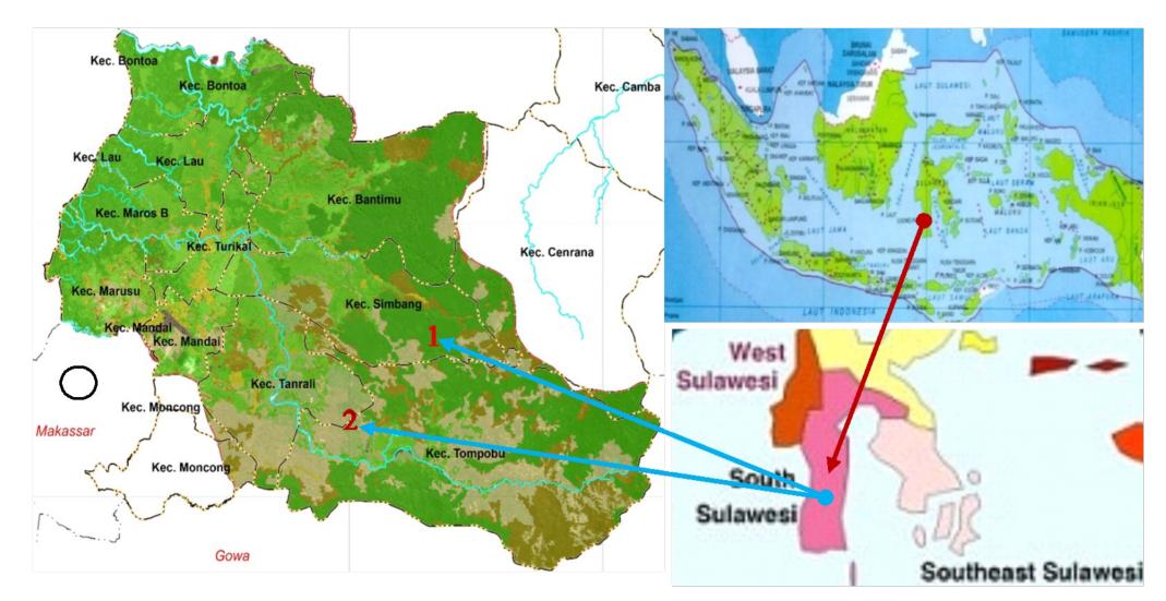
Figure 1. Data Collection Location in Tanralili SubDAS, (1) Secondary dryland forest, (2) Mixed dryland agriculture, Maros Regency, South Sulawesi, Indonesia (google earth pro)
respective return periods. This runoff discharge, which is assumed to be the rainfall intensity with a return period, was run three times for each treatment. The treatment in question is before and after the biopore Absorption hole (BAH) intervention at each test location. Runoff discharge control uses a valve for each flow test period. Measurement of flow discharge as surface runoff, by collecting using a bucket equipped with a peilscal meter, to measure the height and volume of runoff and record the time required to flow.
While the infiltration amount data is obtained from the difference in direct runoff. To ensure the accuracy and reliability of the measurement, all equipment is calibrated before use, to ensure accurate and valid results that can be used as an evaluation of BAH performance as an analysis of surface runoff reduction and increased infiltration as an effort to mitigate sustainable peak flood discharge.
Setting all tools and materials with a 1000 m3 water tank equipped with a control valve for the Rain Intensity period (I1, I5 and I10). Validation of all tools and materials in good condition for data collection, and simulation without Biopore Infiltration Holes (BAH) is carried out by recording the time, volume of surface runoff for each period of rainfall intensity. Initial calibration and simulation without BAH to ensure data accuracy, for the needs of data analysis and further discussion.
Next is the setting of the Bipore Infiltration Hole (BAH) material, ensuring that all tools, materials and materials are in good condition. Before the simulation, tool validation is carried out to ensure that the equipment is in very good condition in data collection. Simulation with BAH for data collection on surface runoff volume and infiltration volume according to the rainfall intensity period (I1, I5 and I10), and the time needed. Data is analyzed to ensure the rationality and suitability of the data, as an analysis and discussion of the results in accordance with the research objectives.
The Tanralili Sub-watershed which is the research location mostly consists of clay soil, especially in the secondary dry forest area (land cover type 1) and mixed dry agriculture (land cover type 2). As a result, surface runoff only transports fine clay particles, with a little coarse material such as gravel or stone. However, the use of infiltration wells (BAH) containing coarse material is still possible, because the wells are equipped with biopore pipe covers designed to prevent the entry of coarse material. However, periodic maintenance is needed to ensure that coarse material and piles of other materials around the BAH can be prevented early and their function is sustainable.
2.3 Construction of Biopore Absorption Holes (BAH)
Biopore Absorption Holes (BAH) are carefully designed to optimize water absorption, increase soil infiltration, and reduce surface runoff through the addition of biodegradable organic materials. The location selection was chosen on critical land, namely mixed dryland agriculture, open land and. Each biopore, measuring 100 cm deep and 10 cm in diameter, has a porous hole diameter of 10 mm on the left and right sides of the biopore PVC pipe with a distance of 10 cm in the vertical direction, to facilitate water absorption and accelerate the decomposition of organic matter (Fathurrahman and Surya, 2024). Biopores are filled with organic materials such as dry tree leaves and twigs, to stimulate microbial activity, improve soil structure, and increase water retention and permeability(Hutabarat and Simanjuntak, 2022) (Naharuddin et al., 2024). To maintain functionality, each BAH is covered with a pipe cap to prevent debris from entering, and monthly checks are carried out to ensure continued performance. Regular monitoring during heavy rainfall provides important data on infiltration rates and soil moisture levels.
2.4 Data analysis
Data analysis assessed the impact of Biopore Absorption Holes (BAH) on runoff and infiltration rates
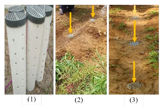
Figure 2. Layout of the research sampling design: (1) 10 cm biopore pipe, 100 cm long, and 10 mm biopore hole; (2) BAH placement model in secondary dry forest areas; (3) BAH placement model in mixed dry agricultural areas.
through a combination of statistical and qualitative methods. Peak discharge was estimated using Nakayasu Synthetic Unit Hydrograph (HSS Nakayasu) (Safitri and Zettyara, 2022), while surface runoff coefficient was calculated through the Rational Method to measure hydrological variation (Utung, Nasjono and Hunggurami, 2021). To evaluate the effectiveness of BAH, a paired t-test (p < 0.05) was performed, statistically significant reduction in surface runoff and increase in infiltration after intervention with BAH. Further rainfall-runoff data analysis contributed the long-term impact of BAH on hydrological stability. In addition, feedback from local stakeholders provided valuable insights into the role of the intervention in reducing flood risk and ease of implementation. By integrating quantitative hydrological assessments with community perspectives, this study demonstrates that BAH serves as a cost-effective and environmentally friendly flood mitigation strategy that supports sustainable watershed management.
3. Results and Discussion
3.1 Soil analysis
Laboratory analysis conducted at three soil sampling points in the Tanralili sub-watershed showed a very low soil permeability of 0.00077 cm/s. This level, categorized as P-4 (very slow), was observed in mixed dry agricultural land, Secondary Dryland Forest, and open land, indicating a very limited capacity of the soil to absorb water. The dominant clay texture, characterized by a high proportion of fine particles and limited pore space, significantly contributes to this low infiltration capacity (Anderson, 2019). Clay tends to be sticky when wet and hard when dry physical properties that inhibit water movement within the soil matrix and increase surface water accumulation (Mello et al., 2022). As a result, surface runoff increases, as rainfall cannot infiltrate efficiently and instead flows across the land surface. This condition exacerbates the risk of erosion, sedimentation, and flooding, especially during periods of high rainfall (Devianti et al., 2022). Soils with such characteristics pose challenges to natural water management and therefore require engineering interventions. One effective solution is the application of Biopore Infiltration Holes (BIH), which are designed to increase vertical water infiltration, reduce surface runoff volume, and support the restoration of local hydrological functions (Basuki et al., 2022).
3.2 Analysis of land use change
Over the past decade, the Tanralili Sub-watershed has experienced significant land-use changes, mainly agricultural expansion and shifting driven by vegetation patterns. In 2020, mixed dryland agriculture has become the dominant land use, covering about 68.33% of the area. Despite a small increase in secondary dryland forest and shrubland, these changes have not been substantial enough to effectively increase infiltration capacity or reduce surface runoff. Widespread implementation of intensive agricultural practices has exacerbated runoff potential and contributed to soil compaction, further reducing the hydrological resilience of the sub-basin. An urgent need is for interventions with the primary objective of restoring watershed balance and improving runoff management strategies. The dominance of mixed dryland agriculture, characterized by intensive land use and reduced vegetation cover, has significantly increased surface runoff and soil compaction within the Tanralili Sub-basin. This pattern is consistent with previous studies linking agricultural expansion to increased runoff and decreased soil permeability (Mehta et al., 2023) (Zhang, Dawes and Walker, 2001) (Roberts et al., 2023). Analysis of the runoff coefficient (C) further indicates the increasing vulnerability of the sub-basin to surface runoff and flood risk. These findings emphasize the need for
Table 1. Land use changes in the tanralili sub-watershed (arc view GIS team analysis)
| Area (km²) | Area (km²) 2015 | (%) | Area (km²) 2020 | (%) | |||
|---|---|---|---|---|---|---|---|
| No | Land Use type | 2010 | (%) | ||||
| 1 | Secondary Dryland Forest | 39.334 | 14.13 | 39.274 | 14.11 | 39.918 | 14.34 |
| 2 | Shrubland | 7.17 | 2.58 | 7.23 | 2.60 | 8.27 | 2.97 |
| 3 | Grass and Tree Vegetation | 2.23 | 0.80 | 2.23 | 0.80 | 1.19 | 0.43 |
| 4 | Mixed Dryland Agriculture | 193.60 | 69.54 | 194.87 | 70.00 | 190.21 | 68.33 |
| 5 | Industrial Plantation Fores | 18.55 | 6.67 | 17.28 | 6.21 | 17.28 | 6.21 |
| 6 | Rice Fields | 16.92 | 6.08 | 16.76 | 6.02 | 19.780 | 7.11 |
| 7 | Water Bodies | 0.564 | 0.20 | 0.72 | 0.26 | 1.493 | 0.54 |
| 8 | Open Land | 0.00 | 0.00 | 0.00 | 0.00 | 0.232 | 0.08 |
| Total | 278.38 | 100 | 278.38 | 100 | 278.38 | 100 |
Table 2. Rainfall intensity analysis using the mononobe equation (analysis team)
| Time | Rainfall Intensity (mm/hour) | |||||||
|---|---|---|---|---|---|---|---|---|
| No | (minutes) | I2 | I5 | I10 | I25 | I50 | I100 | I200 |
| 1 | 5 | 287.631 | 343.204 | 377.142 | 420.142 | 450.460 | 480.300 | 509.814 |
| 2 | 10 | 181.196 | 216.205 | 238.065 | 264.673 | 283.772 | 302.570 | 321.163 |
| 3 | 15 | 138.278 | 164.996 | 181.678 | 201.983 | 216.558 | 230.904 | 245.093 |
| 4 | 20 | 114.146 | 136.201 | 149.972 | 166.733 | 178.765 | 190.607 | 202.320 |
| 5 | 25 | 98.368 | 117.374 | 129.242 | 143.686 | 154.055 | 164.260 | 174.354 |
targeted hydrological interventions to enhance infiltration capacity, restore watershed stability, and strengthen resilience to adverse impacts of land-use change.
3.3 Runoff coefficient analysis
The. runoff coefficient (C) for the Tanralili Subwatershed, determined using the Kawakami empirical method and Rainfall Intensity, (Safitri and Zettyara, 2022) was obtained with an average of 0.520, indicating high vulnerability to surface runoff, especially during periods of high rainfall. The consequences of land use changes, including reduced vegetation cover, reduce infiltration and significantly increase surface runoff. Similar patterns have been observed in other watersheds, such as the Upper Citarum, where C values range from 0.50 to 0.55 due to deforestation and agricultural expansion(Atharinafi and Wijaya, 2021). Mixed dryland agriculture, which covers 68.33% of the Tanralili Subwatershed, shows a dominance of land cover. This causes a decrease in organic matter, and sparse vegetation can trigger high surface runoff and low infiltration. (Guo et al., 2021). These results indicate that flood mitigation reduces runoff, increases infiltration capacity, and sustainable watershed management.
3.4 Rainfall intensity
Rainfall intensity analysis in Tanralili Sub-DAS, rainfall data was obtained from the hydrology section of the South Sulawesi Provincial Water Resources Service. The rainfall station uses three stations, namely Tanralili, Tompobulu and Batu Bessi Stations. This data was analyzed using the Mononobe equation to obtain rainfall intensity as described in Table 2 above, to identify shortduration to high-intensity rainfall events as the main variables for surface runoff and peak flood discharge. For a duration of 5 minutes during a 50-year return period, the rainfall intensity exceeded 450 mm/hour, indicating the vulnerability of the sub-DAS to major floods. These extreme rainfall events generate rapid surface runoff, exceeding the infiltration capacity of the watershed and significantly increasing the risk of flooding. Reduced vegetation cover further amplifies this hydrological response, a pattern consistent with other flood-prone areas where extreme rainfall events accelerate runoff generation and peak discharge levels.
The rainfall intensity observed in the Tanralili Subwatershed shows similarities to patterns in tropical regions, such as Annual rainfall in the upper reaches of the Bengawan Solo watershed varies between 1,433.5 mm to 3,231.2 mm with an average reaching 2,224.6 mm
(Auliyani and Wahyuningrum, 2020). This high intensity rainfall is characteristic of areas influenced by monsoonal weather patterns and climate variability, both of which drive extreme rainfall events (Thompson, 2024)(Choi and Kim, 2022). These conditions substantially increase the formation of surface runoff, thereby increasing the risk of flooding in vulnerable watersheds. Changes in rainfall patterns in the watershed result in an increase in peak runoff discharge (Ahab, Limantara and Prayogo, 2016). This shows that the need for flood mitigation is very important to minimize the hydrological impacts of extreme weather conditions and increase watershed resilience.
3.5 Changes in flood peak discharge
3.5.1 Hydrograph of peak flood discharge changes due to surface runoff reduction interventions across various land use types
The application of Biopore Infiltration Holes (BAH) with a pore diameter of 10 mm can significantly reduce peak flood discharge in various types of land use in the Tanralili Sub-DAS. Massive application in DAS land management is important as an effort to mitigate flooding with its intensity in each period getting shorter. The most significant reduction occurs in agricultural land and secondary dry forests, where BAH increases infiltration and reduces surface runoff due to intensive land use. In contrast, shrub land and open land show moderate reductions due to higher infiltration rates and lower surface runoff rates. This shows the importance of adapting BAH interventions to land use. The BAH approach method shows optimal potential to overcome surface runoff dynamics as a trigger for peak flood discharge. The observed variation in effectiveness shows the influence of soil permeability, vegetation cover, and land use patterns in triggering hydrological responses, which shows the ability to adapt and sustainable strategies for flood risk reduction and increasing watershed resilience.
Surface runoff reduction with Biopore Absorption Hole (BAH) Intervention showed results by slowing and reducing the magnitude of the peak flood discharge by an average of 34.60%, as depicted in Figures 3, Figure 4 and Figure 5, on open land types, Mixed Dryland Agriculture Use and Shrubland. This illustrates that the suitability of BAH to reduce frequent flooding requires action by addressing high-intensity scenarios due to climate change(Fernández-Nóvoa et al., 2022). Integrate BAH with broader flood control strategies to increase resilience across flood intensities.
Figure 3. Hydrograph of peak flood discharge changes due to surface runoff reduction through Biopore AbsorptionHole (BAH) Intervention with 10 mm pore diameter on open land use
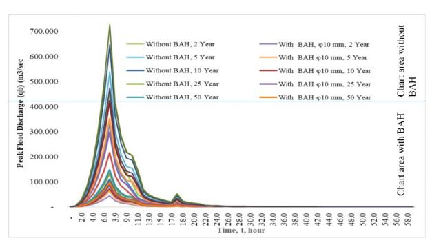
Figure 5. Hydrograph of peak flood discharge changes due to surface runoff reduction through Biopore Absorption Hole (BAH) intervention with a 10 mm pore diameter on shrubland use
This finding is in line with previous studies that emphasize the role of biopores in increasing soil infiltration, increasing the capacity of rainwater absorption into the soil (Bahunta and Waspodo, 2019) and reducing surface runoff (Atharinafi and Wijaya, 2021). Biopore Absorption Holes (BAH) have shown performance in managing frequent flooding. As an effort to encourage sustainable water resource management in various ecosystems. However, optimizing extreme flood reduction is highly dependent on the massive use of this method and integrated watershed management. Combining BAH with structural measures, such as retention basins or embankments, can strengthen overall resilience and address various flood intensities, thereby encouraging a more comprehensive and adaptive watershed management strategy (Shaikh et al., 2023).
The application of Biopore Infiltration Holes (BAH) in the management of River Basin Areas (DAS) is a potential and easy method approach that can be carried out by every individual or community group sustainably to reduce the risk of flooding (Roberts et al., 2023). Consistent with previous research (Li et al., 2020), it shows the role of BAH in delaying peak flood discharge and reducing runoff rates, especially during frequent floods. In the Tanralili Sub-watershed, a peak discharge reduction of 34.60% across various land cover types further validates the scalability and practicality of BAH as a flood mitigation strategy in tropical watershed environments. These results
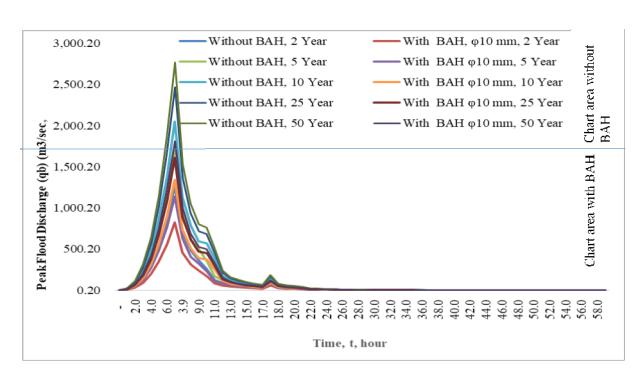
Figure 4. Hydrograph of peak flood discharge changes due to surface runoff reduction through Biopore Absorption Hole (BAH) intervention with 10 mm pore diameter on mixed dryland agriculture use
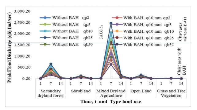
Figure 6. Changes in peak flood discharge hydrograph with surface runoff reduction through Biopore Absorption Hole (BAH) Intervention with biopore diameter of 10 mm on various types of land cover
indicate that BAH promotes sustainable and adaptive water resources management.
3.4.2 Impact of biopore absorption hole intervention on peak flood discharge across land use types
The application of Biopore Absorption Holes (BAH) with a pore diameter of 10 mm consistently reduces peak flood discharge in various types of land use in the Tanralili Sub-watershed. Hydrograph analysis (Figures 6 and 7) showed significant reductions in peak discharge across land cover types such as; mixed dryland agriculture, secondary dryland forest, shrubland, open land, and grass/tree vegetation. The intervention proved most effective in areas with higher base runoff, such as mixed dryland agriculture and secondary forest, compared to naturally permeable landscapes such as grassland and open land. These findings highlight the adaptability and efficacy of BAH in reducing flood risk across a range of land use settings, particularly in areas prone to increased runoff. This suggests its potential as an optimal solution for sustainable watershed management (Fan and Shibata, 2015).
The findings further emphasize the strong correlation between land-use characteristics and the effectiveness of BAH in reducing flood peaks. By enhancing infiltration and minimizing surface runoff (Fynnisa et al., 2024) (Bahunta and Waspodo, 2019), BAH offers a targeted approach to flood risk management,
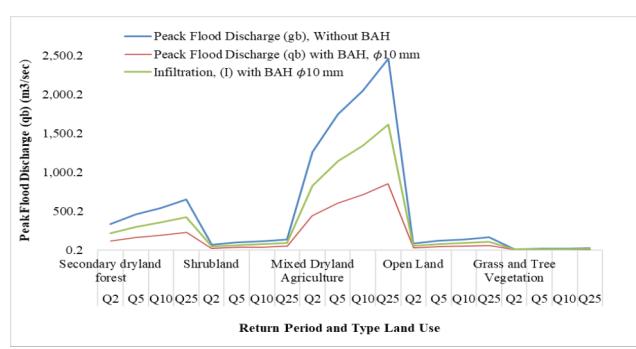
Figure 7. The effect of biopore absorption hole (BAH) Intervention on peak flood discharge by reducing surface runoff and increasing infiltration on various types of land cover.
particularly in areas with compacted soils or sparse vegetation. Its adaptability across diverse land-use conditions highlights its potential as a scalable, naturebased strategy for strengthening watershed resilience. As a cost-effective and environmentally sustainable intervention, BAH serves as a practical solution for mitigating flood risks while fostering long-term hydrological stability.
Hydrograph analysis (Figures 6 and Figure 7) shows the significant impact of Biopore Infiltration Holes (BAH) in reducing peak flood discharge in various types of land cover in the Tanralili Sub-DAS. The results of the study showed a substantial decrease in surface runoff, with an average decrease of 34.60% in various types of land cover. This decrease directly affects the decrease in peak flood discharge, which also reached an average of 34.60%, as illustrated in Figure 6.
These findings highlight the effectiveness of BAH in reducing surface runoff, especially in areas where land use changes have occurred. Reducing peak flood discharge has various benefits, including disaster mitigation, environmental protection, and socioeconomic benefits. By reducing the intensity and duration of inundation, adverse impacts on residential and urban areas can be minimized. This highlights the importance of implementing BAH interventions in open spaces and areas with high runoff as a proactive measure for effective flood mitigation.
Large-scale BAH implementation has implications for critical landscapes, including agricultural zones, residential areas, and open spaces, helping to restore the natural function of watersheds as water catchments and groundwater recharge areas. A targeted and strategic approach can further enhance the efficiency of BAH, making it a scalable and sustainable solution.
Figure 7 shows a significant decrease in surface runoff, reaching 34.60%, and with an increase in infiltration of 65.37% in several types of land cover in the Tanralili sub-watershed. This shows the potential of Biopore Absorption Holes (BAH) as an intervention, especially in critical land, including agricultural areas, settlements, and open land within the watershed. The results of field application tests carried out in the Tanralili sub-watershed showed that BAH significantly
reduced surface runoff by an average of 34.60% while increasing infiltration by up to 65.37%. The effect of reducing surface runoff and increasing infiltration contributed to a lower peak flood discharge, as depicted in Figures 6 and Figure 7 (Liu et al., 2022). By slowing the intensity and duration of floods, it has an impact on protecting public safety and supporting the sustainability of ecosystems and water resources. This intervention functions as an important flood mitigation strategy. The impact of increasing frequency and intensity of disasters, as an impact of climate change due to global warming. The massive application of BAH or a combination of other methods is a priority as an action to adapt to climate change and mitigate flooding. In the last five years, the intensity and frequency of flood disasters have continued to increase. Land use interventions, especially in areas that have experienced land conversion, must be concerned with reducing surface runoff and increasing infiltration through the application of BAH, and regulations are needed that regulate land conversion and interventions to reduce surface runoff and increase infiltration.
Integrating BAH interventions with other methods, such as infiltration wells and ecological restoration, is a promising engineering solution for flood mitigation. Previous studies (da Silva Diniz, Scudelari and de Medeiros, 2024) have demonstrated the effectiveness of hybrid solutions in enhancing infiltration while regulating high-intensity runoff, in line with similar findings from the Tanralili Sub-basin. This integrated approach strengthens resilience in flood-prone areas, offering a sustainable and adaptive framework for effective watershed management and flood control (Destry, Purnaweni and Syafrudin, 2015).
These findings demonstrate Biopore Absorption Holes (BAH) as a promising nature-based solution for flood mitigation and climate change adaptation(Fernández-Nóvoa et al., 2022), particularly in areas experiencing significant land-use change and hydrological disturbances. The adaptability of BAH across land cover types supports sustainable watershed management by reducing flood risk, enhancing groundwater recharge, and strengthening ecosystem resilience (Fernández-Nóvoa et al., 2022)(Putri et al., 2024).
4. Conclusion
The results of the study indicate that Biopore Absorption Holes (BAH) are one of the potentials to overcome the problem of peak flood discharge in the Tanralili Sub-DAS.
1. BAH intervention significantly reduced surface runoff from 92.75% to 62.34% and increased infiltration from 5.21% to 77.73%, indicating its capacity to increase soil absorption and reduce flood risk. These findings indicate the potential of BAH to strengthen watershed resilience, support groundwater recharge, and manage recurring flood events.
- 2. Reduction in runoff by 34.60% and increase infiltration by 64.37%, indicating significant BAH performance in delaying peak flood discharge, increasing watershed resilience, and supporting groundwater recharge. The results of this study make BAH one of the sustainable solutions to improve hydrological balance.
- 3. The implementation of Biopore Absorption Holes (BAH) in the Tanralili Sub-DAS must be carried out comprehensively and in an integrated manner. This is done using a technical approach through mapping and building appropriate infrastructure, an ecological approach that focuses on soil and water conservation, and a continuous monitoring and evaluation system. By implementing this strategy, mitigation of peak flood discharge risks can be significantly reduced, while increasing regional resilience to hydrometeorological disasters.
Acknowledgement
This research is supported by Research Grant Fund Batch VI, 1687.016/PT/I.3/D/2022. We express our deepest gratitude to the Muhammadiyah Menjelis Dikti Central Leadership for the financial support that has been provided, so that this research can be carried out properly.