
ABSTRAK
Deklarasi Djuanda diproklamasikan pada tanggal 13 Desember 1957, akan tetapi baru pada tahun 2000, PBB mengeluarkan sebuah kewajiban bagi Pemerintah Republik Indonesia untuk menentukan batas laut sebagaimana dinyatakan dalam amandemen UUD 1945. Beberapa peraturan terkait batas laut dan zona maritim sebenarnya sudah ada, yaitu: Undang-Undang tentang Landas Kontinen Indonesia (1973), Undang-Undang tentang Zona Ekonomi Eksklusif Indonesia (1983), dan Undang-Undang tentang Perairan Indonesia (1996). Pemerintah Indonesia, untuk pertama kalinya pada tahun 1999, mengeluarkan Undang-Undang tentang Pemerintahan Daerah, yang menyatakan bahwa ada otoritas regional dalam mengelola wilayah laut sejauh 12 mil dari garis pantai. Penelitian ini membahas sejauh mana hubungan antara penentuan batas laut Republik Indonesia berdasarkan Konvensi PBB tentang Hukum Laut (UNCLOS) pada tahun 1982 dan batas laut regional yang merujuk pada Undang-Undang tentang Pemerintahan Daerah. Metode penelitian yang digunakan adalah analisis korelasi antara hukum dan peraturan yang terkait dengan batas laut nasional dan regional. Hasil penelitian menunjukkan bahwa penentuan batas laut nasional menggunakan baseline yang mengacu pada posisi permukaan laut terendah, sedangkan untuk batas laut regional menggunakan garis pantai pada posisi pasang tertinggi. Hal ini menunjukkan bahwa sama sekali tidak ada hubungan antara batas laut nasional dan batas laut regional Republik Indonesia. kata kunci: deklarasi djuanda, batas laut nasional dan regional, analisis korelasi, garis dasar, garis pantai.
INTRODUCTION
Before Indonesia's independence, the regulation of sea boundaries was based on the 1939 Ordinance, where the Indonesian Territorial Sea stretched toward the sea up to three nautical miles from each island's tidal lines. After Indonesia's independence, a concept emerged where the waters between the islands had to become an inseparable part of the mainland, which later became famous for the concept of the archipelago insight.
The announcement of the Indonesian Government known as the Djuanda Declaration on December 13th, 1957 had a significant impact, because all waters around, between, and connecting the islands and a reasonable part of the Indonesian mainland were under the absolute sovereignty of the Indonesian State. The territorial sea boundary is set as far as 12 nautical miles from the line connecting the outer islands. In order to have legal force, the Djuanda Declaration was confirmed in the form of Government Regulation in Lieu of Law (Perpu) No. 4 of 1960 (Kusumaatmadja, 1986).
Since the Perpu was issued (February 18th, 1960), the provisions of the 1939 Ordinance no longer appli ed. Further developments were marked by the formation of a number of laws related to sea boundaries and maritime zone, such as Law Number 1 of 1973 concerning the Indonesian Continental Shelf, Law Number 5 of 1983 concerning Indonesia's Exclusive Economic Zone, and Law No. 6 of 1996 concerning Indonesian Waters which replaced Perpu No. 4 of 1960. Further Government Regulation (PP) No. 61 of 1998 concerning the List of the Geographical Coordinate of Indonesian Archipelago Basepoints in the Natuna Sea was issued and subsequently replaced by PP No. 38 of 2002 concerning Listing of the Geographic Coordinate of Indonesian Archipelago Basepoints.
One of the obligations that must be fulfilled by Indonesia is that it has ratified the 1982 UN Convention on the Law of the Sea (United Nations, 1983)
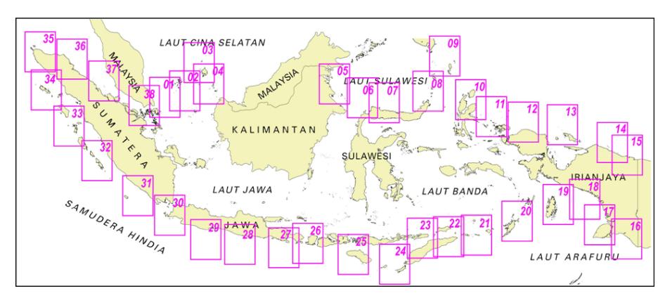
Figure 1 Index of Indonesian Archipelago Baseline Map (Dishidros, 1995)
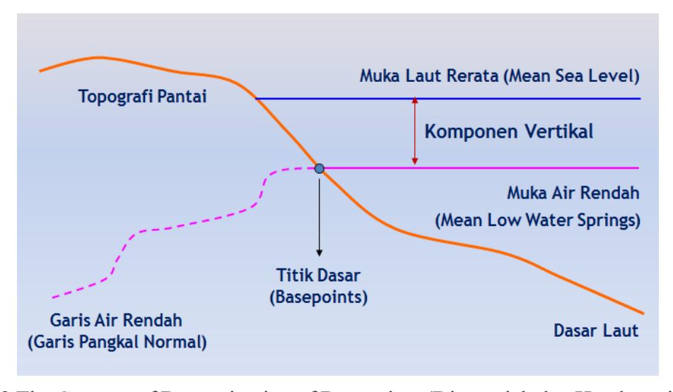
Figure 2 The Concept of Determination of Basepoints (Djunarsjah dan Handayani, 2018)
through Law No. 17 of 1985 to officially announce and submit copies of sea boundary maps or in the form of geographical coordinates of sea boundary points to the Secretary General of the United Nations (United Nations, 2000). The separation of the Sipadan and Ligitan Island from the territory of Indonesia prompted the government to revise Government Regulation No. 38 of 2002 with Government Regulation No. 37 of 2008.
After reforms in 1998, the government system in Indonesia was changed to a regional autonomy-based system. The regulations that protect it from Law No. 22 of 1999 were changed to Law No. 32 of 2004, and now it is Law No. 23 of 2014 concerning Regional Government. The similarity of the three laws is that the determination of the sea authority for the province in the sea area is 12 nautical miles from the coastline. Each region has both land and sea areas, which are bordered by archipelagic waters or by the high seas.
Sea Boundary Issues Area NKRI
To fulfill its obligation to deposit the sea boundaries to the Secretary General of the United Nations, Indonesia conducted a Basepoint Survey from 1989 to 1991 (Dishidros, 1995) and continued with Verification of the Basepoint Survey between 1993 and 1996 (Norway Mapping Group and Bakosurtanal, 1995). The results are listed in Government Regulation No. 38 of 2002 and the Indonesian Archipelago Baseline Map whose index map can be seen in Figure 1. Based on a 2002 International Court decision, the islands of Sipadan and Ligitan which were previously claimed by Indonesia were decided to belong to Malaysia. Consequently, the three basepoints on both islands must be revised. Along with the separation of the East Timor Province into a new country, the previous regulation was revised to Government Regulation No. 37 of 2008. The basic principle of determining basepoint can be seen in Figure 2.
In determining the sea boundary of the State of Indonesia (unilateral), the problem lies on the selection of basepoints to be used, while for adjacent or opposite (bilateral/trilateral/multilateral) sea boundaries, reaching agreement is the main thing by using the principle of equidistant. The sea boundary is determined from the points drawn in such a way that it has the same distance to the nearest starting point which is located in each coastal state. If it does not agree with the above principle (equidistant), then the agreement of both parties is based on the principle of equitable solution.
The status of the sea border agreement between Indonesia and neighboring states can be classified as follows:
- • There has been the agreement and has been ratified,
- • There has been the agreement but not yet ratified, and
- • Sea borders are still problematic, meaning they have not been resolved through agreements or other forms of agreement.
With regards to the agreements of sea boundary between Indonesia and neighboring states, 17 (seventeen) sea boundary agreements have been established, with 16 (sixteen) agreements among which have been ratified (see Table 1), while one further agreement has not been ratified (see Table 2). The rest is still in the process of negotiation, and some are not negotiated at all.
Correlation Analysis between the Stipulation of Sea Border of NKRI Region and the Sea Boundary of Regional Authority
Based on Article 27 paragraph 3 of Law No. 23 of 2014 on Regional Government, it is stated that the Provincial
| No. | Agreement | Approval | Ratification |
|---|---|---|---|
| INDONESIA - MALAYSIA | |||
| 1 | Continental shelf in the Malacca Straits and South China Sea | 27-10-1969 | Presidential Decree 89/1969 |
| 2 | Territorial Sea in the Malacca Strait | 17-03-1970 | Law 2/1971 |
| INDONESIA - SINGAPURA | |||
| 3 | Territorial Sea in the Singapore Strait | 25-05-1973 | Law 7/1973 |
| 4 | Territorial Sea in the Straits of Western Singapore | 10-03-2009 | Law 4/2010 |
| 5 | Territorial Sea in the Eastern Singapore Strait | 03-09-2014 | Law 1/2017 |
| INDONESIA - AUSTRALIA | |||
| 6 | Specific Seabed | 18-05-1971 | Presidential Decree 42/1971 |
| 7 | Specific Seabed (the Timor Sea and Arafura) | 09-10-1972 | Presidential Decree 66/1972 |
| 8 | Specific Boundary of Indonesia and Papua New Guinea | 12-02-1973 | Law 6/1973 |
| INDONESIA - MALAYSIA - THAI- LAND | |||
| 9 | Continental Shelf North of the Strait of Malacca | 21-12-1971 | Presidential Decree 20/1972 |
| INDONESIA - THAILAND | |||
| 10 | Continental Shelf of the North of the Strait of Malacca and the Andaman Sea | 17-12-1971 | Presidential Decree 21/1972 |
| 11 | The Seabed in the Andaman Sea | 11-12-1975 | Presidential Decree 1/1977 |
| INDONESIA - INDIA | |||
| 12 | Shelf Boundary | 08-08-1974 | Presidential Decree 51/1974 |
| 13 | Extension of the Continental Shelf Boundary 1974 | 14-01-1977 | Presidential Decree 26/1977 |
| INDONESIA – INDIA - THAILAND | |||
| 14 | Trijunction Point and Boundary from Specific Boundaries in the Andaman Sea | 22-06-1978 | Presidential Decree 24/1978 |
| INDONESIA - VIETNAM | |||
| 15 | Continental Shelf Boundary on North Natuna Island | 06-06-2003 | Law 18/2007 |
| INDONESIA - FILIPINA | |||
| 16 | Exclusive Economic Zone Boundary | 23-05-2014 | Law 4/2017 |
| · |
| TABLE II LIST OF THE SEA BOUNDARY AGREEMENTS BETWEEN INDO |
|---|
| NESIA AND NEIGHBORING COUNTRIES WHICH HAS NOT BEEN RATIFIED |
| No. | Agreement | Approval | Ratification |
|---|---|---|---|
| INDONESIA - AUSTRALIA | |||
| 1 | Exclusive Economic Zones and Specific Seabed | 14-03-1997 | - |
One of the notes from Table 2 is the maritime boundary agreement between Indonesia and Australia that was completed in 1997, but until now the agreement has not been ratified.
Authority to manage natural resources at sea as referred to in Article 1 is 12 (twelve) nautical miles which are measured from the coastline towards the high seas and or the archipelagic waters. The management of natural resources as referred to in paragraph 1 includes:
- a. Exploration, exploitation, conservation and management of marine resources outside of oil and gas
- b. Administrative settings
- c. Spatial arrangement
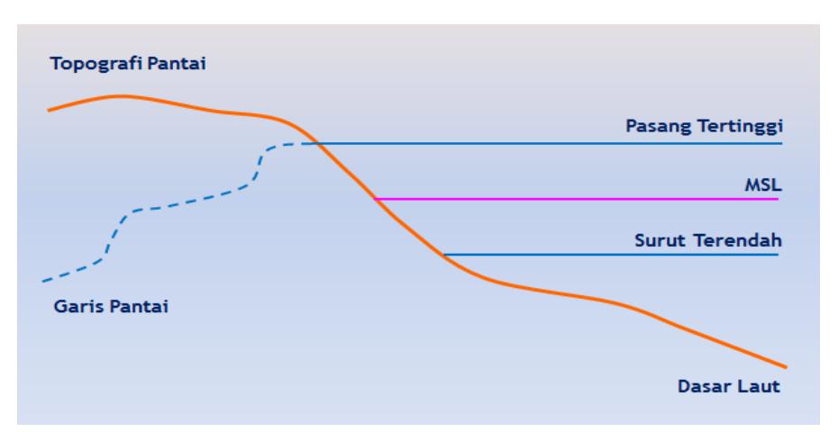
Figure 3 The Basic Principle in the Determination of the Coastline for the Limits of Regional Authority
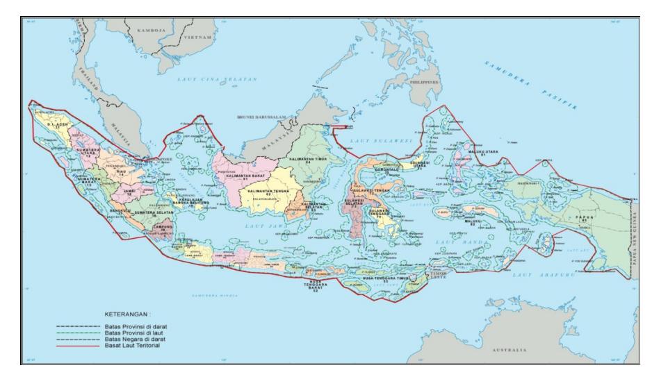
Figure 4 Illustration of the Withdrawal of the Provincial Sea Boundaries of the Coastline (Ministry of Internal Affairs, 2012)
- d. Participation in maintaining security at sea
- e. Participation in maintaining state sovereignty.
The basic principle in the determination of the coastline is shown in Figure 3, while the principle in the withdrawal of provincial authority boundary for 12 (twelve) nautical miles can be seen in Figure 4.
If the sea area between the two Provinces is less than 24 (twenty-four) nautical miles, the authority to manage
natural resources at sea is equally spaced or measured in accordance with the equidistant principle of the sea boundary between these two Provinces (see Figure 5). The results of the division of the provincial sea boundary in Indonesia under this provision can be seen in Figure 6.
It is clear that the boundary of the state of Indonesia using basepoints which refer to the position of the low water line in this case is the mean low water springs, while for sea boundary of province, the reference used is the coastline at the highest tide position. As a result,
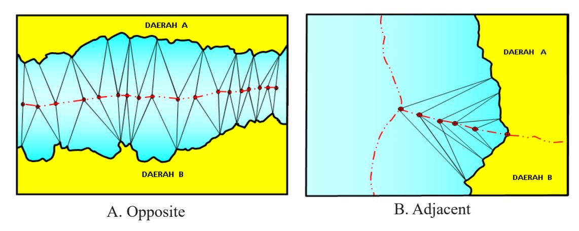
Figure 5 Illustration of Sea-Boundary Drawing between Oppsite and Adjacent Provinces (Ministry of Internal Affairs, 2012)
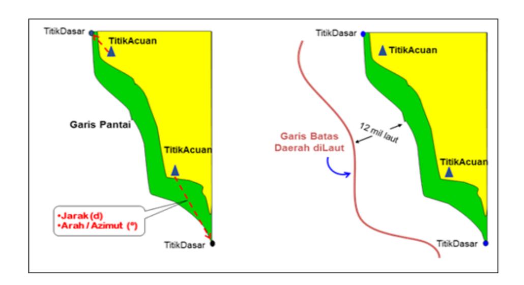
Figure 6 Division of the Provincial Sea Region in Indonesia (Bakosurtanal, 2007)
the basepoints used for the determination of the sea boundary of the Republic of Indonesia cannot be used for the determination of the provincial authority's sea boundary. In addition, if the determination of the sea boundary of the Republic of Indonesia is based on direct survey of the field through the Basepoint Survey, then the sea boundary of the provincial authority can be done graphically on the basemaps available (IHO, 2014), among them Nautical Chart produced by The Center for Hydrographic Oceanography of the Navy (Pushidrosal) and the Topographic Map, the Coastal Environment Map of Indonesia, and the National Marine Environment Map produced by the Geospatial Information Agency (BIG).
Sovereignty is a very valuable thing for a coastal state because it is the highest power possessed by a country. An independent country is called a sovereign state because it has fulfilled several requirements, including having territory, people, government, and recognition from other countries. The territory here relates to the land and at the same time to the oceans, which are the extension of state power on land. The boundary of the territory thus becomes very important because it concerns the sovereignty of the country both in land and sea territory. Therefore, the success of sovereign enforcement must be preceded by the determination of the boundaries of the entire territory of the country.
The lack of correlation between the state sea boundary and the provincial sea boundary has the potential to cause serious problems in upholding the sovereignty of Indonesia's administrative region. This creates inefficiencies in budgeting for implementation. Furthermore, if observed technically, many things are out of sync, for example in the use of vertical datum to determine the base point (the state sea boundary uses the position of water at low tide, while the provincial
authority's limit at sea uses the position of high water), not including the survey scale and different map scales (Indonesian Baseline Maps use 1: 200,000 scale, while Indonesian Exclusive Economic Zone Maps and Indonesian Continental Shelf use 1: 1,000,000 map scale, compared to provincial authority boundary maps using maps with a scale of 1: 500,000).
CONCLUSION
Based on the description above, it can be concluded several important things:
- a. In determining the state sea boundary using the baseline, it refers to the position of the low water line, while for the regional sea boundary, the reference used is the coastline at the highest tide position. This shows that there is no link at all between the national sea boundary and the regional sea boundary of the Republic of Indonesia.
- b. There needs to be an effort from the Government of Indonesia to create integration between state sea boundary and provincial sea boundary so as to reduce the emergence of serious problems in upholding the sovereignty of Indonesia's administrative region.