
ABSTRAK
Kementerian Agraria dan Tata Ruang/Badan Pertanahan Nasional (ATR/BPN) menargetkan terwujudnya peta desa yang lengkap dan valid. Program strategis ini dilakukan dengan memetakan seluruh bidang tanah, termasuk data fisik dan yuridis sehingga dapat tercipta database pertanahan yang akurat. Penelitian ini bertujuan menganalisis kolaborasi tiga pemangku kepentingan: Kantor Pertanahan, Pemerintah Kota/Kabupaten, dan Pemerintah Desa dalam mewujudkan peta desa yang utuh. Penelitian ini dilakukan dengan menggunakan metode deskriptif kualitatif. Pengumpulan data dilakukan dengan tiga cara yaitu wawancara, data sekunder, dan observasi lapangan. Analisis data dilakukan secara spasial pada data utama dan data pendukung untuk peta desa yang lengkap. Hasil penelitian menunjukkan bahwa kolaborasi dan berbagi data (peta pendaftaran tanah, peta zona nilai tanah, peta blok PBB, peta Rencana Tata Ruang Wilayah (RTRW), dan peta rinci Huruf C Desa) antara ketiga pemangku kepentingan merupakan variabel penting untuk membangun peta desa lengkap. Kajian ini membuktikan bahwa kolaborasi ketiga pemangku kepentingan mampu mempercepat terwujudnya database desa yang lengkap dengan hasil yang sesuai dengan persyaratan dan kriteria yang ditetapkan Kementerian ATR/BPN. Selain itu, integrasi data yang dilakukan dapat digunakan untuk mewujudkan desa satu data, yang diharapkan mampu memberikan masukan bagi pemerintah dalam merumuskan kebijakan.
Kata kunci: desa lengkap, database pertanahan, kerja sama, pemangku kepentingan, pendaftaran tanah sistematis lengkap.
INTRODUCTION
Complete-Systematic Land Registration (PTSL) as a strategic program of the Ministry of ATR/ BPN with a target of certifying 5 million land parcels in 2017, 7 million land parcels in 2018, 9 million land parcels in 2019, and by 2025 it is expected that all land parcels in Indonesia registered is an effort to provide legal certainty, add land value, and improve community welfare (Directorate of Cadastral Measurement and Mapping, Ministry of ATR/BPN 2018; Arnowo, 2019; Amir et al., 2020; Sirait et al., 2020). As stipulated in Article (3) of the Regulation of the Minister of ATR/BPN No. 6 of 2018, the object of PTSL covers all land parcels without exception, both land parcels with and without land rights. This scheme aimed to register and map all land parcels targeted as the objects of PTSL in the village and improve the quality of the data, so as to be able to create the complete village database (Ardani, 2019).
The complete village realization can be done by mapping all village land parcels, including physical and juridical data to produce a valid land database. This land database aims to serve as a foundation for the implementation of various policies regarding land regulation, so that it cannot only be used by the Ministry of ATR/BPN but also by various other agencies. The complete village is a forum for reducing land disputes and problems, providing legal certainty for the clarity of land parcels and for maintaining sustainable maintenance of land data (Ulfah & Suwondo 2019; Sari & Jumiati, 2019). This complete village mapping is expected to be able to produce complete, accurate, and valid land parcel data that can encourage the realization of one map policy and government (Surdin, 2016; Damanik & Purwaningsih 2017).
Various efforts were made by the Ministry of ATR/BPN, the Regional Office of BPN, and the Land Office considering the challenges and problems in achieving the complete village and PTSL experiencing various obstacles (Alawiya, 2018; Hidayat, 2018; Iryanto et al., 2019; Kartiwi & Hasyim, 2019). Marryanti & Purbawa (2018) shows that the factors of limited human resources, limited computers, limited measuring instruments, regional morphological conditions/
slopes, and low perceptions and innovations often hinder the achievement of complete village and PTSL as targeted. In addition, there are still a lot of land data included in Cluster 4 (KW4, KW 5, and KW 6) where land parcels have not been mapped, resulting in the often hampered realization of the complete village. If ignored, this condition can result in overlapping maps of land parcels that lead to land conflicts (Kusmiarto, 2017; Artika & Utami, 2020). Optimizing innovation and strengthening community participation (Hemaphan 2017) and collaboration between stakeholders become one of the driving forces to solve these problems.
The work of the land office in implementing this strategic program can be seen from the many innovations that have emerged in order to accelerate the completion of PTSL and the realization of the complete village (Fisko, 2015; Silviana & Ardani, 2018; Ministry of ATR/BPN 2020). This was done to improve the performance of the land office and increase the role of BPN as a problem solver and quality land service provider (Kurniati & Fakhriah, 2017).
Researchers have reviewed various innovations to accelerate strategic programs, including complete village acceleration through community participation and the use of measurement and mapping technology (Mirza, 2019; Rachma, 2019; Artika & Utami, 2020). Currently, one that has been implemented in accelerating the PTSL and complete village in various land offices is community involvement (Wardani, 2019).
Apart from PTSL+PM, innovation development is also being carried out, one of which is at the Klaten Regency Land Office through community participation and collaboration of three stakeholders. Stakeholder collaboration is not only able to produce responsive decisions to interests and stakeholders' value but also help resolve conflicts and build trust among stakeholders (Gregory et al., 2020). This collaboration scheme was implemented by the Klaten Regency Land Office and has proven to be successful in completing the Complete Village target which has been difficult to achieve in other areas.
Based on the above background, this study aimed to analyze the successful collaboration of the community and three stakeholders in realizing the complete village, as well as examining data sharing to accelerate the realization of the complete village. A study related to collaboration between stakeholders is expected to be able to encourage and provide solutions to the problems faced in realizing the complete village.
METHOD
This research was conducted in Kokosan Village, Prambanan, Klaten. The map of study site is presented in Figure 1.
physical condition of the Measurement Letter (SU) and related Situation Figure (GS); b) preparing satellite images at the research location and superimposing maps consisting of valid land data that meet the provisions in the Guidelines for Complete City/Regency Land Registration 2019; c) overlaying valid land data against supporting data in the form of PBB block map for the Klaten Regency and detailed village map; d) positioning the parcels according to their actual position on site through Graphical Index Mapping (GIM) independently/in studio, GIM in a participatory manner on screen with the help of village officials and field surveys.
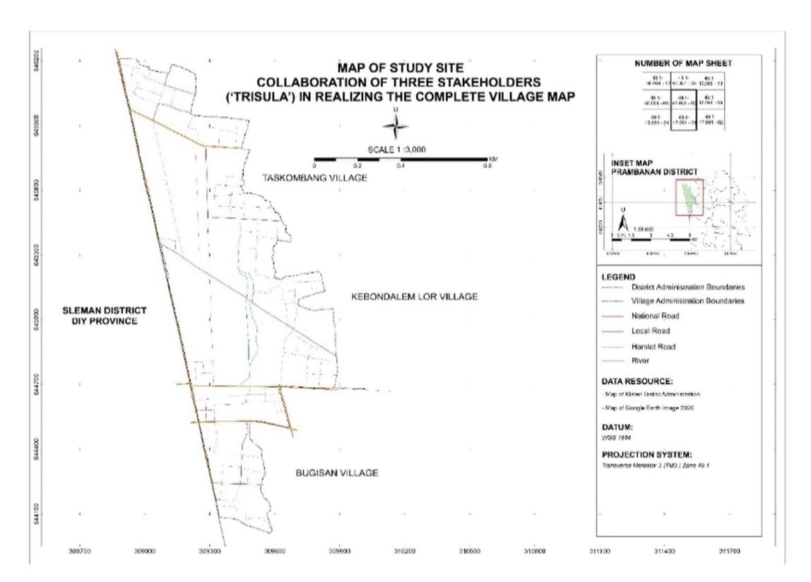
Figure 1 The map of study site in Kokosan Village
This village was chosen because it is one of the complete village mapping pilot projects of the Klaten Regency Land Office. This study used a qualitative-descriptive method, in which the preparation of the complete village map was carried out through spatial analysis.
The steps taken in the complete village manifestation were a) collecting data on land parcels classified based on the quality of the KW1-KW6 data to be analyzed against the
GIM is a method that can be used in digital mapping to find the location of land parcels that have been registered in the base map in order to know the relative position of the land parcels to the surrounding conditions. e) overlaying GIM resulted data against other supporting maps, namely the 2011-2031 Regional Spatial Plan (Rencana Tata Ruang Wilayah - RTRW) map and the Land Value Zone (Zona Nilai Tanah - ZNT) map.
In this study, data were collected from the land office, local government office, village office, desk study, and field activities involving assistance from village officials and owners of land parcels. This was done as an effort to position the land parcels if the independent/participatory GIM on screen wasless valid. Quantitative data include the village administration area, the total area of valid parcels, the number of complete village potentials, the percentage of data quantity, the percentage of data quality, the number of parcels according to data quality (KW1 to KW6), the number of valid parcels in one village, and other data. Meanwhile, qualitative data include data on types of land rights, data on land use, data on spatial patterns, data on land value zones, and other data.
RESULTS AND DISCUSSIONS
Valid Complete Village Mapping
Complete village is the implementation of complete land data in a village. Complete village can be categorized into two, namely spatially and non-spatially complete (PTSL Technical Guidelines 2021). Spatially complete means that all objects of land registration in the form of land parcels including geographic elements (rivers, roads, etc.), certified and not yet certified, which are in the form of land registers. This spatially complete data must meet the requirements, that is, it has been mapped in the KKP application and there are no gaps or overlaps. Prihanto (2016) stated that the preparation of a complete village map is an activity of mapping land parcels carried out in one village administrative area which aims to collect data on ownership of land parcels, whether certified or not.
Considering that the complete village mapping activity goes hand in hand with the implementation of PTSL, the data and metadata must match the specified criteria. Likewise, the maps produced must also comply with the complete village terms and conditions according to the PTSL Technical Guidelines 2020 and directions from the Data and Information Center (Pusdatin) of the Ministry of ATR/BPN.
PTSL Technical Guidelines for Regencies/ Cities (2019) explains that the validity of land data is the condition of the land parcels that meet the aspects of the correctness of location, shape, area, and numbering standards. As an effort to make a complete village mapping data valid, it is necessary to validate it to determine the quality degree of land data. The land data in a village need to be integrated or linked-up so that textual data and spatial data are connected to each other as a condition for valid land data. Furthermore, Nugroho (2020) explained that to improve the quality of land data in the land office, it is necessary to improve the quality of data on unmapped land parcels in the KKP system (KW 4, 5, 6) into KW 1 land parcels.
As regulated in the PTSL Technical Guidelines 2021, land parcels in PTSL activities can generally be classified into Cluster 1 (K1), Cluster 2 (K2), Cluster 3 (K3) and Cluster 4 (K4). In Cluster 4 (K4), there are data on KW4, KW5 and KW6, where the existing data are not yet feasible and do not meet the requirements to be used as a land map. The data criteria for KW 1 to KW 6 are presented in Table I.
TABLE I QUALITY CRITERIA FOR SPATIAL DATA AND TEXTUAL DATA
| Data Quality (KW) | |||||||
|---|---|---|---|---|---|---|---|
| Data Availability | KW1 | KW2 | KW3 | KW4 | KW5 | KW6 | |
| Mapped Plots | √ | √ | √ | x | x | x | |
| Spatial GS/SU | √ | x | X | √ | x | x | |
| Textual GS/SU | √ | √ | X | √ | √ | x | |
| Land Book | √ | √ | √ | √ | √ | √ | |
Source: PTSL Technical Guidance 2021
For land parcels that were being upgraded from KW4, KW 5 and KW 6 to KW 1, validating the KKP application can be done to ensure the level of data accuracy. Some of the requirements that must be met during validation are as follows.
- 1. Position suitability: can be done on a certified land parcel on conditions that there are at least two adjacent neighbors according to their positions or by checking the GU for adjacent land parcels that are not yet certified.
- 2. The area on the map and on the SU documents do not exceed tolerance. The tolerance for area difference is ≤ 5%.
\[Tolerance (\%) = \underline{ | map area - SU area | \times 100\% }\]
\(SU\) area
- 3. Suitability of the shape of land parcels. It means the geometric shape of the land parcels in the KKP is in accordance with the shape of the Spatial SU.
- 4. Link between physical data and juridical data. Land book (right number), measuring letter both in spatial/textual form (SU number), and land parcel (NIB) have been entered, valid, and interconnected/linked (where analog and digital data must be synchronous).
The validation process carried out by fulfilling the requirements mentioned above certainly controls the physical accuracy of land parcel data when viewed from the area, shape, position/location as well as the suitability of data presentation between physical and juridical data.
Collaboration Of The Three Stakeholders
The theory of collaborative governance mentions that this concept is a resolution of public problems that are often implemented by the government in carrying out administrative governance in order to be able to produce solutions that are implementable and can be utilized by various parties (Irawan, 2017). Although the implementation shows that awareness of the need for stakeholder involvement is complex, it is difficult and often failed (McComb et al. 2017). Likewise, a study by Nabiha & Saad (2015) states that the stakeholder engagement process is often complicated and problematic due to the unclear roles and responsibilities of the many entities involved and a lack of strategy at both the top and local levels. Several factors hindering the success of this participation and collaboration include the lack of political will of policy makers at the planning stage and lack of participation and awareness of stakeholders at the implementation stage (Kala & Bagri, 2018; Sutrisno & Akbar, 2018).
Despite various challenges, this collaboration between stakeholders is one of the innovations developed by the Klaten Land Office and is the key to the success of a complete village mapping. The three stakeholders referred to in this study are the Klaten Regency Land Office as the leading sector, the Klaten District Government Office, and the Kokosan Village Office as partners and pilot project locations. Based on the results of the analysis of the complete village development process, it shows that the roles and tasks of the three stakeholders are able to accelerate the complete village mapping. Collaboration of three stakeholders and community participation becomes an arena of information and data sharing of each stakeholder. The paper work of sharing data and information activity of the three stakeholders are presented in Figure 2.
Figure 2 shows information/data sharing provided by each stakeholder. The compiling process for a complete village involved roles and interests of each of the collaborating stakeholders. This is what has led to the success of a complete village program. The mapping of the roles, duties and outcomes of the three stakeholders in the complete implementation of village mapping is presented in Table 2.
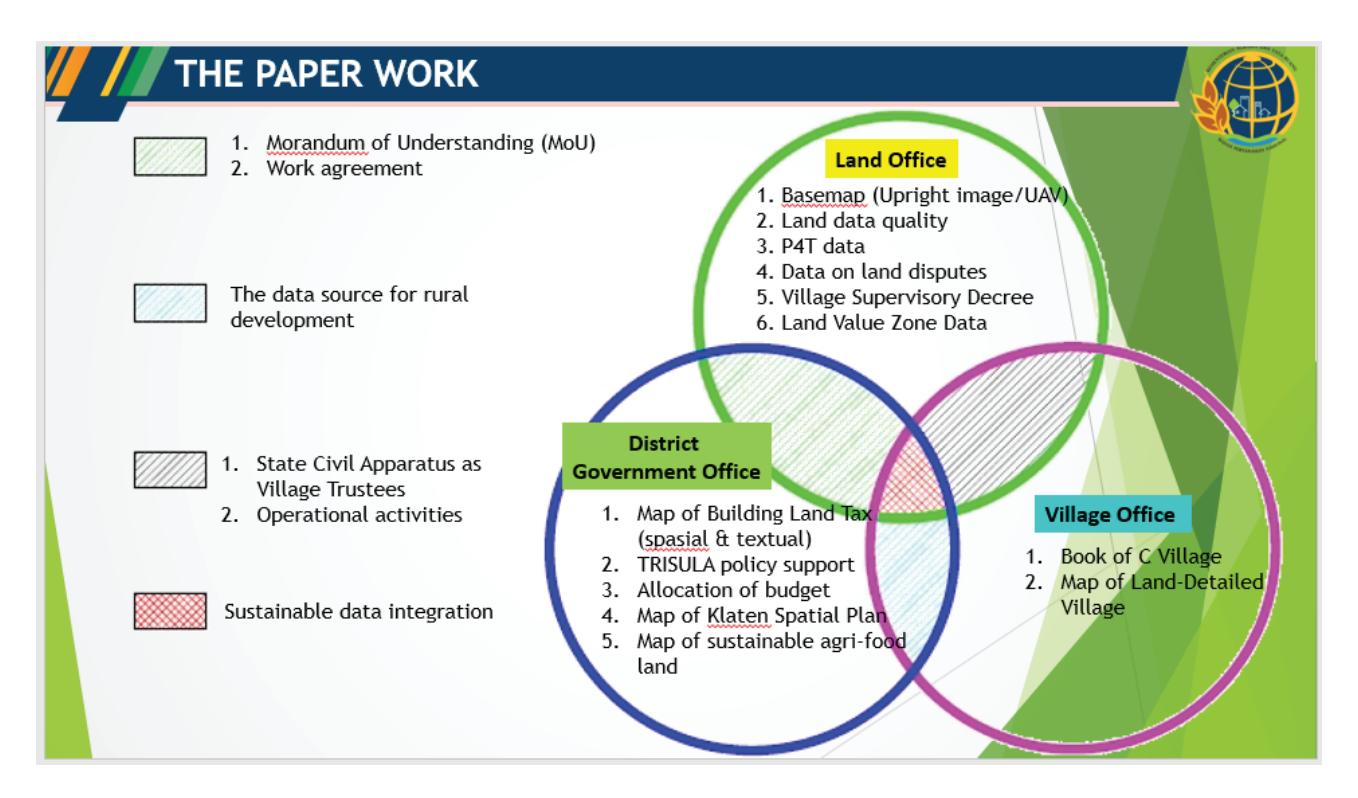
Figure 2 Complete Village Mapping Working Paper through Collaboration of Three Stakeholders, Source: The Klaten Regency Land Office 2020
TABLE II ROLES, DUTIES AND OUTCOMES OF THE THREE STAKEHOLDERS
| No. | Stakeholder | Role and Duty | Outcome | |||
|---|---|---|---|---|---|---|
| 1 | The Regency Office | Klaten a. Land | Preparing electronic land data as the basis for complete village development. The land | a. | The realization of field-based land data in every village that are valid and sustainable | |
| data includes: registration maps, measurement letters, situation drawings/ measurement drawings, and | b. c. | Increasing the degree of quality of the land database at the Klaten Regency Land Office a fully digital system that can be | ||||
| b. | land books. Preparing other supporting data that can accelerate complete village development, such as: satellite 2020 image basemap, IP4T data, land dispute data, land use data, land value zone data and other data that has | d. e. f. | realized at the Klaten Regency Land Office by utilizing valid electronic data, Steps to accelerate towards modern land office Instruments for inventorying land problems and disputes The realization of a land parcel based appraisal program with up | |||
| c. | been overlaid with the same reference. Arranging job description, especially the village person in charge as an extension of the land office. | g. | to-date data Instruments for monitoring the activities of the Inventory of Control, Ownership, Use, and Utilization of land (IP4T) | |||
- 2 The Klaten Regency Government Office
- a. Preparing supporting data needed by the Land Office such as: Map of Regional Spatial Planning, PBB Block Map (DHKP).
- b. Formulating policies in district government to support and encourage Trisula activities
- c. Allocating local-sourced budgets for Trisula activities
- d. Preparing human resources as a support system for land office officers in order to support the realization of a complete village. These human resources include employees within the Klaten district government who are appointed by the Regent.
- 3 Kokosan village officials and/or community
- a. Preparing supporting data needed by the Land Office such as: Detailed Map of Land, Letter C Data, etc.
- b. Formulating policies in village government to support and facilitate Trisula activities
- c. Allocating village budget for Trisula activities
- d. Preparing human resources in the village as a support system for land office officers, examples: youth organizations or village officials
- e. Assisting the implementation of the identification of land parcels on screen as well as direct surveys and mapping in the field.
- a. The use of complete village maps resulting from the trident as a basis for determining spatialbased policy making by local governments
- b. The main instrument for making various thematic maps
- c. Material for consideration for accelerating the preparation of the Detailed Spatial Plan (RDTR)
- d. Basic considerations for the realization of One Single Submission (OSS) public service
- e. Containers and sources of information on potential areas based on land parcels in the context of facilitating investment activities
- f. Instrument to control, monitor and maintain the integrity of Sustainable Food Agricultural Land (LP2B).
- g. Integration of taxation data and regional population data into the results of the Trisula map so that big data is realized in one portal
- a. Basic materials for determining the direction of village development in Musrembang activities
- b. The complete village map from the Trisula that can be used, instead of the manual (analog) detailed village map.
- c. Acceleration of updating village data practically based on digitalspatial
- d. Basic materials for making various village thematic maps for village development purposes
- e. Instruments to reduce land disputes and conflicts in the village
- f. The basic ingredients for realizing a smart village based on information technology
- g. Development of a complete village map from the trident to create a website or android-based village information system
The success of the collaboration of the three stakeholders was initiated by the problem of data asynchronization, the absence of valid, complete, and accurate data and ineffective land administration governance systems. The process of discussion and strategic planning as well as data sharing has been proven to facilitate the achievement of a complete village. One data village in the form of a complete village in Kokosan Village has met the complete and valid requirements both spatially and juridically (PTSL Technical Guidelines, 2021). Good relations among stakeholders and this collaboration add to the expectation of a success rate in realizing a valid land database.
A collaborative governance scheme implemented in Kokosan Village in realizing this complete village shows the level of success. Goldsmith (2009) and Kurniasih, (2017) stated a concept that collaborative governance success is indicated by the presence of: a) Networked Structure between stakeholders with equal rights, access, and responsibilities; b) Commitment to a Common Purpose; c) Trust Among the Participants; d) Goversnance, namely the clarity of the agreed rules; e) Access to Authority, that is, each party can understand and carry out their roles according to their authority; f) Distributive Accountability/Responsibility; g) Information
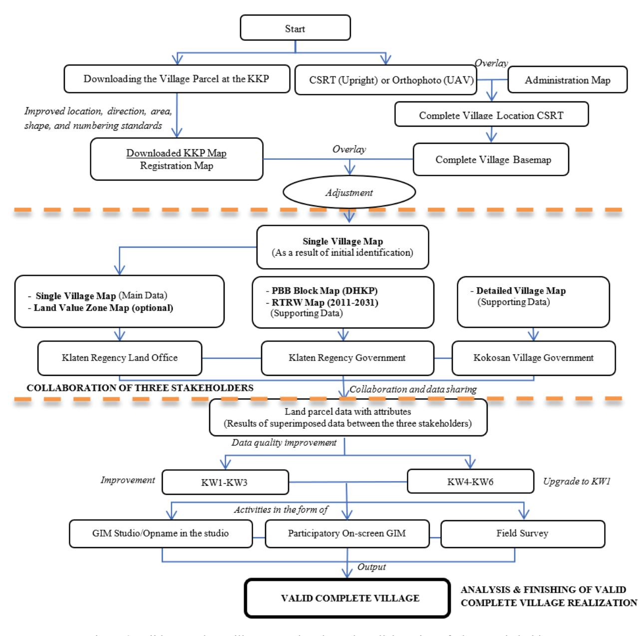
Figure 3 Valid, Complete Village Mapping through Collaboration of Three Stakeholders
Sharing, marked by sharing of nformation and access to information; and h) access to resources, meaning that there is clarity regarding the availability of resources for each stakeholder.
Valid Complete Village Mapping Framework Through Collaboration Of Three Stakeholders
To encourage the acceleration of a complete village, the Klaten Regency Land Office took a strategy through the collaboration of three stakeholders. Based on the results of the evaluation and analysis of the implementation of the complete village embodiment that has been implemented, the land office realized that the complete village embodiment is strongly influenced by the adequacy and quality of land data in the village. Regarding this condition, it is neccessary to analyze the supporting data that can help accelerate the valid complete village mapping. Based on the complete village preparation process, the collaboration of three stakeholders is presented in Figure 3.
Implementation Of Complete Village Mapping
In carrying out a valid complete village mapping, an accurate land database is needed. The following is a detailed explanation regarding the stages of the complete village mapping through a collaboration of the three stakeholders.
1. Preparation Stage
- a) Initial Preparation: at this stage, coordination was carried out related to determining villages and formulating strategic activities.
- b) Preparation for downloading spatial and textual data
- c) Preparation of human resources; this stage was carried out in coordination with village officials to conduct socialization.
2. Implementation and Data Processing
This stage begins with improving the spatial and textual data. The data must meet the correctness of location, direction, area, shape, and numbering standards (City/ Regency Land Registration Technical Guidelines, 2019). The land data were integrated or linked-up so that textual data and spatial data were interrelated (connected) as a condition towards valid land data. Furthermore, for land data that have been integrated, it is necessary to carry out validation and revalidation activities of land data in order to improve the quality of land data towards KW1.
Furthermore, the researchers conducted a Graphical Index Mapping (GIM) which aims to re-land registered land parcels that cannot be mapped with floating conditions (flying parcels) to be back to the National TM 3º coordinates and be stored in electronic database. In this study, GIM consists of: a. Independent/ studio GIM; b. Participatory on screen GIM assisted by village officials, namely Head of Government Division, Head of Hamlet, and Head of Neighborhood.
3. Finishing step of a complete village mapping
The above series of activities were carried out continuously until there were no KW1-KW6 plots of land left (all of which have been mapped on the complete village map). If all the land parcels data were completely mapped in a single village map, the last step taken was validating the land parcels in the KKP application and checking all the required requirements for the complete village. The results of the complete village mapping are presented in Table III.
| TABLE III RESULTS OF COMPLETE VILLAGE MAPPING OF |
|---|
| KOKOSAN VILLAGE |
| No. | Criteria | Results | No. | Criteria | Results |
|---|---|---|---|---|---|
| 1 | Administrative area | 983.98m2 | 5 | BT validation percentage | 95.45% |
| 2 | The parcel area | 983.98m2 | 6 | Percentage of land parcel validation (area) | 93.93% |
| 3 | The parcel area is valid | 950.98m2 | 7 | Percentage of parcel validation (field) | 90.01% |
| 4 | Total BT amount | 1214 files | 8 | Percentage of scanned letter | 92.92% |
Source: https://ptsl.atrbpn.go.id/BidangTanah/HeaderKantah
TABLE IV QUALITY OF LAND DATA BEFORE AND AFTER COMPLETE VILLAGE MAPPING
| Data quality | Land data before the village is complete | Land data after the village is complete |
|---|---|---|
| KW 1 | 746 plots of land | 590 plots of land |
| KW 2 | 324 plots of land | 592 plots of land |
| KW 3 | 13 plots of land | 0 plots of land |
| KW 4 | 52 plots of land | 0 plots of land |
| KW 5 | 119 plots of land | 27 plots of land |
| KW 6 | 5 plots of land | 5 plots of land |
| Total | 1259 plots of land | ts of land |
From the result of analysis in Table III and Table IV, the suitability of the complete village percentage requirements is as follows:
- (1) Percentage of Land Book Validation (BT): Addition of Total Valid BT/(Total BT - Initial Valid BT) (see Table 1) √
- (2) Percentage of Land Parcel Validation: Addition of Valid Parcel Area/(Area - Initial Valid Parcel Area) - (see Table 1) √
- (3) Percentage of Scanned Documents: (Scanned BT Documents + Scanned Files with Published Right) - Scanned Initial Documents/(Total BT - Scanned Initial Documents) - (see Table 1) √
(4) Percentage of Complete Village Value:
a) If the Area is equal to the Total Parcel Area, the value = Average percentage of BT validation, percent validation of parcels, or scanned documents
\[(95.45\% + 9.93\% + 90.01\% + 92.92\%) / 4 = 93.08%
- b) If the Area is not equal to the Total Parcel Area, the value = 0
- c) Tolerance of the Difference in Parcel Area from Area: 99.995% <(Parcel Area/Area * 100) 100.005% Area = parcel area 9.995%<(983.98/983.98*100) <100.005% 9,995% < 100 <100.005% √
- d) Tolerance of KW4-KW6 Amount: (Total KW4-KW6/Total BT) * 100 <= 5% ((0+27+5)/1214)*100 = 0.002 => 2% √
- e) Tolerance of KW4-KW6 Area: (Area of KW4-KW6 / Parcel Area * 100) <= 3.5% √
- f) PTSL Documents: Scanned files whose rights are published √
Based on the analysis of the complete village final products and juxtaposed with the criteria set by the Center for Data and Information of the Ministry of ATR/BPN in 2020, it can be concluded that the complete village mapping product for Kokosan in 2020 has been in line with the terms and criteria, as listed on the PTSL dashboard website of The Land Office of Klaten Regency: https://ptsl.atrbpn.go.id/BidangTanah/ HeaderKantah.
Superimposed Map of Registration of the Land
In this study, spatial data were superimposed, between the land registration map against the PBB block map, DHKP List data, and the detailed C village map. The result of the overlay in a land parcel is a synchronization between the Field Identification Number (NIB) and the Tax Object Number (NOP). In addition, in the preparation of the complete village, spatial data analysis was also carried out between the land registration map against the RTRW map and the ZNT map for Klaten Regency. The results of map processing and analysis are in accordance with Figure 4 below.
Figure 4 shows that if the registration map data is done by superimposing PBB map, DHKP data, detailed village C map, RTRW map, ZNT map, and other supporting maps while maintaining their respective attributes, this step can be used to compile multipurpose land database prototype. A cause-effect analysis regarding the results of the Kokosan Village database used the superimposed main data and supporting data as shown in Table V.
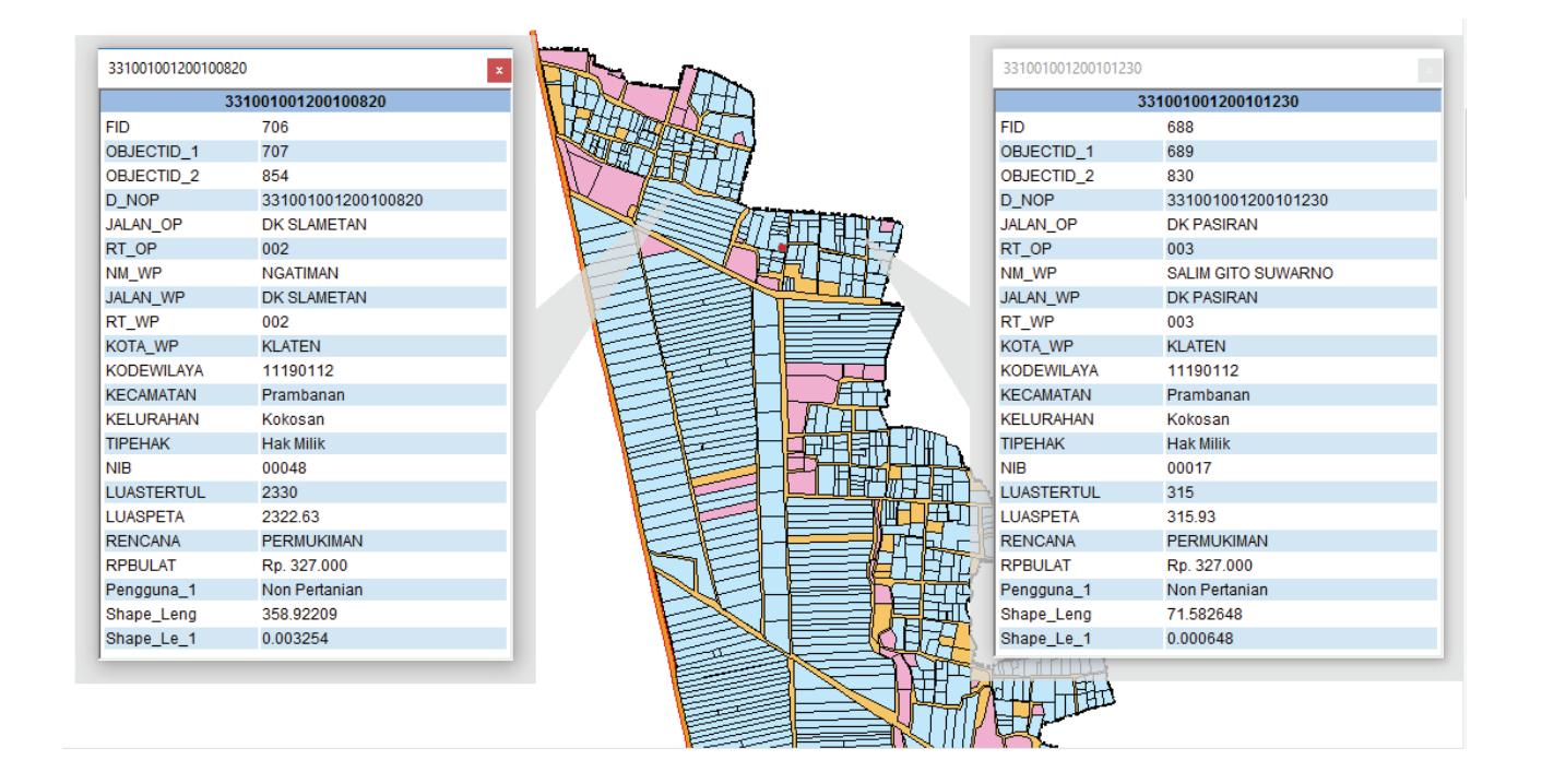
Figure 4 Superimposed Registration Map of PBB Block Map, DHKP Data, Village Detailed Map, RTRW Map, and ZNT Map.
TABLE V CAUSE-EFFECT ANALYSIS OF KOKOSAN VILLAGE DATABASE
No Cause-effect Analysis of Kokosan Village Database
- 1 Cause: recapitulation of land parcels that is in line with the database of Klaten Regency Land Office registration map is as many as 1214 parcels. Meanwhile, recapitulation of land parcels that is in line with PBB map database and DHKP data from The Klaten Regency Government Office is 1003 parcels.
- Effect: there were a number of differences in the recapitulation of land parcels in Kokosan Village, which is 211 plots of land. Based on the researchers' analysis, this is because that the level of updated maps from each agency is different (further research is needed).
- 2 Cause: there were as many uses of the existing land parcels that were not in accordance with the RTRW of Klaten Regency 2011-2031 as many as 128 plots of land. Effect: the difference in land use in the Kokosan Village area against the spatial pattern of Klaten Regency is due to changes in land use change from agriculture to non-agriculture (mostly into settlements). The data show 128 land parcels experiencing incompatibility land use against the existing RTRW principles. This needs to be a serious concern by the Klaten Regency Government to take strategic policy steps related to the ongoing RTRW Regional Regulation or other policies concerning the land owner and the land parcel concerned.
Source: Researchers' data analysis 2021
Map of Kokosan Village Land Plots through a Collaboration of Three Stakeholders
The map of land parcels is very important for the village government and the Klaten Regency government in carrying out land activities and as a basis for making policies. This land plot map can be a valid and up-to-date base map. By sharing with one valid land database, there will be a synchronization between agencies because the data used are the same. In addition, all land problems and other problems that cover the authorities across agencies will certainly be easier to solve with a valid land database. The realization of one data village throughout Klaten Regency becomes very possible if there is a good relationship and cooperation among stakeholders. In the end, it is hoped that the village government and district government will be able to develop this map according to their respective needs.
CONCLUSION
A valid complete village mapping through the collaboration of three stakeholders needs to consider several things: good relations among stakeholders, integrated cooperation among stakeholders, data and information sharing, as well as a commitment to achieving common goals. In this collaboration, the three stakeholders should be able to share data; no stakeholder bans access to data or information, to support the success of the program. A valid complete village mapping through the collaboration of the three stakeholders has an important role because the resulted outcome can provide benefits for each stakeholder.
The collaboration of the three stakeholders in the preparation of a complete village in Kokosan Village was able to create a valid land database by fulfilling the correct aspects of location, direction, area, shape, and numbering standards which were synchronized between: NIB against NOP, DHKP data, data land value zone and RTRW data for Klaten Regency 2011- 2031. With the developed one data village, the three stakeholders could build a valid database for sharing, one of which was manifested in a map of land parcels that can be used by the three of them as well as data utilization according to user needs. This one-data village, carried out through the collaboration of the three stakeholders, was able to meet the complete village criteria set by the Ministry of Agrarian Affairs/BPN's Center for Data and Information, PTSL Technical
Guidelines 2020, and Complete City/Regency Land Registration Technical Guidelines 2019.
ACKNOWLEDGEMENTS
Our gratitude goes to the Head of the Klaten Regency Land Office who has allowed the authors to publish the complete village mapping through the collaboration of three stakeholders. Furthermore, the authors would like to thank the colleagues of the STPN KKNPTLP Team at the Klaten Regency Land Office in 2020.
REFERENCES
- Alawiya, S., Kristiyanto, & Wicaksono, A. (2018). Pelaksanaan kegiatan projek percepatan pelaksanaan Pendaftaran Tanah Sistematis Lengkap (PTSL) di Desa Sukobubuk Kecamatan Margarejo Kabupaten Pati. Jurnal UMK.
- Amir, R. A., Barus, B., & Soetarto, E. (2020). Dinamika Spasial Tanah Terdaftar dan Implikasinya terhadap Sistem Penghidupan Masyarakat Lokal di Kabupaten Takalar. Journal of Regional and Rural Development Planning, 4(2), 134–153. https://doi.org/10.29244/ jp2wd.2020.4.2.134-153
- Ardani, M. N. (2019). Tantangan Pelaksanaan Kegiatan Pendaftaran Tanah Sistematis Lengkap dalam Rangka Mewujudkan Pemberian Kepastian Hukum. Jurnal Gema Keadilan, 1(III), 11. http://www. albayan.ae
- Arnowo, H. (2019). Pola Pemberdayaan Masyarakat Pasca Pendaftaran Tanah Sistematis Lengkap (PTSL) the Pattern of Community Empowerment After Complete Systematic Land Registry (PTSL). 1(1), 14–23.
- Artika, I. G. K., & Utami, W. (2020). Percepatan Pembenahan Data Bidang Tanah Kluster 4 melalui Survei Data Pertanahan. BHUMI: Jurnal Agraria dan Pertanahan, 6(1), 66– 79. https://doi.org/10.31292/jb.v6i1.425
- Damanik, MP, Purwaningsih, EH. (2017). E-government dan aplikasinya di lingkungan pemerintah daerah (Studi kasus kualitas informasi website Kabupaten Bengkalis Provinsi Riau). Jurnal Studi
- Komunikasi dan Media, vol. 21, no. 2, 151-164.
- Fisko. (2015). Pentingnya Peta Desa. Bhumi : Jurnal Agraria Dan Pertanahan, 1(1), 69–73.
- Goldsmith, S, Donald FK 2009, Unlocking the power of networks: keys to high performance government, Brookings Institution Press: Washington, D.C.
- Gregory, A. J., Atkins, J. P., Midgley, G., & Hodgson, A. M. (2020). Stakeholder identification and engagement in problem structuring interventions. European Journal of Operational Research, 283(1), 321–340. https://doi.org/10.1016/j. ejor.2019.10.044
- Hemaphan, P. (2017). Determinant of stakeholder participation towards sustainable tourism development: An empirical study of active beach destinations in Thailand'. Sripatum Review of Humanities and Social Sciences, (pp. 103-114). Retrived from https://so05. tci-thaijo.org/index.php/spurhs/article/ view/113155%0A
- Hidayat, K. R. (2018). Dampak Alih Fungsi Lahan Terhadap Sosial Ekonomi Petani (Studi Kasus Pembangunan New Yogyakarta International Airport Desa Glagah, Kecamatan Temon, Kabupaten Kulon Progo). 1–26.
- Irawan, D. (2017). (Studi Deskriptif Proses Pemerintahan Kolaboratif dalam Pengendalian Pencemaran Udara di Kota Surabaya). Kebijakan dan Manajemen Publik, 5(3), 1–11.
- Iryanto, B., Mandey, L. C., Pakasi, C. B. D., Perencanaan, I., Wilayah, P., Pascasarjana, P., & Sam, U. (n.d.). The Study of the Complete Systematic Land Registration (PTSL) Process in the Land Office of North Minahasa Regency Bagus Iryanto, Lucia C. Mandey, dan Caroline B. D. Pakasi Ilmu Perencanaan Pembangunan Wilayah Program Pascasarjana Universitas Sam Ratulang.
- Kala, D., & Bagri, S. C. (2018). Barriers to local community participation in tourism development: Evidence from mountainous state Uttarakhand, India. Tourism, 66(3), 318–333.
- Kartiwi, M., & Hasyim, S. Bin. (2019). Implementasi Kebijakan Pemerintah di Bidang Pendaftaran Tanah Sistematis Lengkap di Kabupaten Garut. Jurnal Ilmu Sosial Politik dan Humaniora, 2(2), 43– 53. https://doi.org/10.36624/jisora.v2i2.45
- Kurniasih, D. (2017). Model Penguatan Kelembagaan pada Program Sanitasi Lingkungan Berbasis Masyarakat (SLBM) di Kabupaten Banyumas (Suatu Pendekatan Collaborative Governance). Sosiohumaniora, 19(1), 1–7. https://doi. org/10.24198/sosiohumaniora.v19i1.7888
- Kurniati, N., & Fakhriah, E. L. (2017). BPN sebagai Mediator dalam Penyelesaian Sengketa Tanah di Indonesia Pasca Perkaban No. 11 Tahun 2016. Sosiohumaniora, 19(2), 95–105. https:// doi.org/10.24198/sosiohumaniora. v19i2.11999
- Kusmiarto. (2017). Problematika Pembenahan Data Spasial Bidang Tanah di Kementerian Agraria dan Tata Ruang/Badan Pertanahan Nasional. Prosiding Seminar Nasional: Problematika Pertanahan dan Strategi Penyelesaiannya, Oktober, 179–187. https://www.researchgate.net/ publication/320211528_Problematika_ Pembenahan_Data_Spasial_Bidang_ Tanah_di_Kementerian_Agraria_dan_ Tata_Ruang_Badan_Pertanahan_Nasional
- Marryanti, S., & Purbawa, Y. (2018). Optimization of Factors That Affect The Success of Complete Systematic Land Registration. BHUMI: Jurnal Agraria dan Pertanahan, 4(2), 190–207.
- McComb, E. J., Boyd, S., & Boluk, K. (2017). Stakeholder collaboration: A means to the success of rural tourism destinations? a critical evaluation of the existence of stakeholder collaboration within the mournes, Northern Ireland', Tourism and Hospitality Research, hlm. 286–297, https:// doi.org/10.1177/1467358415583738
- Mirza, T. (2019). Implementasi Kebijakan Pelaksanaan Percepatan Pendaftaran Tanah Sistematis Lengkap (PTSL) (Studi Kasus pada Kantor Badan Pertanahan
- Nasional Kabupaten Ogan Ilir. Jurnal Ilmu Pemerintahan dan Politik Global, 04(02), 2502–2032.
- Nabiha, S.A.K. & Md. Saad, N. H. (2015). Tourism planning and stakeholders' engagement: the case of Penang Island', Problems and Perspectives in Management, 269–276.
- Nugroho, R.W. (2020). Uji kualitas data spasial peta bidang tanah hasil peningkatan kluster 4 (k4) pada sistem geokkp (komputerisasi kegiatan pertanahan) di Kantor Pertanahan Kabupaten Klaten (Studi di Desa Pakahan, Kecamatan Jogonalan, Kabupaten Klaten). Yogyakarta: Sekolah Tinggi Pertanahan Nasional.
- Rachma, Y. (2019). Pelayanan Pendaftaran Tanah Sistematis Lengkap (PTSL) oleh Kantor Pertanahan Kabupaten Pangandaran. Moderat, 5(November), 11.
- Sari, Y., & Jumiati. (2019). Evaluasi Berjalan Terhadap Program Pendaftaran Tanah Sistematis Lengkap (PTSL) di Kota Padang. 1(3), 1–12.
- Silviana, A., & Ardani, M. N. (2018). "Sinden Bertapa" Metode Menuju Tertib Adminidtrasi Bidang Pertanahan (Studi di Desa Trisari Kecamatan Gubug Kabupaten Grobogan). Masalah-Masalah Hukum, 47(3), 282. https://doi.org/10.14710/ mmh.47.3.2018.282-297
- Sirait, S. Y., Nazer, M., & Azheri, B. (2020). Sertifikasi Tanah Program Pendaftaran Tanah Sistematis Lengkap : Deskripsi dan Manfaatnya Land Certification Of Complete Systematic Land Registration Program : Description and Benefits Magister Perencanaan Pembangunan , Universitas Andalas Fakultas Ekonom. 6(2), 236–248.
- Surdin, J., & Ilmu. (2016). Analisis Kelayakan Implementasi E-Government dalam Pelayanan Publik di Bidang Keagrariaan di Kabupaten Pinrang. Komunikasi KAREBA, 5(1), 178–191.
- Sutrisno, B., & Akbar, I. (2018). E-partisipasi dalam pembangunan lokal (studi
- implementasi. Jurnal Sosioteknologi, 17(2), 8–12. http://journals.itb.ac.id/index. php/sostek/article/view/6384/3402
- Ulfah, MS, Suwondo, D. (2019). Pelaksanaan pendaftaran tanah sistematis lengkap (PTSL) di Kabupaten Demak. Konferensi Ilmiah Mahasiswa Unissula (KIMU) 2. Semarang: Universitas Islam Sultan Agung.
- Wardani, A. E. P. (2019). Participatory Land Registration (Palar) dalam Percepatan Pendaftaran Tanah Sitematik Lengkap (PTSL) di Provinsi Bali. Seminar Nasional Geomatika, 3, 59. https://doi. org/10.24895/sng.2018.3-0.927
- Peraturan Perundang-undangan
- Peraturan Menteri Agraria dan Tata Ruang/BPN Nomor: 6 Tahun 2018 tentang Percepatan Pendaftaran Tanah Sistematis Lengkap.
- Petunjuk Teknis Menteri Agraria dan Tata Ruang/Badan Pertanahan Nasional. 2020 tentang Pendaftaran Tanah Sistematis Lengkap Tahun 2020.
- Petunjuk Teknis Nomor 003/JUKNIS-300. UK.01.01/II/2019 tentang Pendaftaran Tanah Kota/Kabupaten Lengkap Tahun 2019
- Petunjuk Teknis Nomor 1/Juknis-100. Hk.02.01/I/2021 tentang PTSL Tahun 2021