
INFO ARTIKEL
Kata kunci:
sedimentasi, pelabuhan, manajemen, kewenangan, revolusi industri 4.0
ABSTRAK
Proses sedimentasi menjadi fenomena fisis yang berpengaruh terhadap manajemen Pelabuhan. Jika diurai lebih lanjut, manajemen Pelabuhan mencakup aktifitas perencanaan, perancangan, konstruksi dan pemeliharaan. Untuk memahami pengaruh sedimentasi terhadap Manajemen Pelabuhan, dilakukan studi komparasi antara ketentuan manajemen pelabuhan yang terdapat dalam regulasi di Indonesia dengan pelaksanaan yang sudah terealisasi di pelabuhan Patimban. Tujuan dari kajian pengaruh sedimentasi terhadap manajemen Pelabuhan digunakan untuk membuat rekomendasi teknis dalam konteks spasial dan temporal yang perlu dilaksanakan oleh otoritas Pelabuhan. Rekomendasi tersebut perlu dilakukan secara berkala, dengan mengintegrasikan data-data perubahan secara temporal dengan teknologi berbasis Revolusi Industri 4.0 untuk meningkatkan pemutakhiran data sehingga pengelola bisa merespon setiap perubahan yang terjadi di Pelabuhan secara tepat dalam waktu yang singkat.
https://doi.org/10.5614/sostek.itbj.2022.21.3.3
Introduction
As an archipelagic country, Indonesia has always strived to provide sufficient connectivity between the islands in its territory in order to equalize development and economic growth. One of the key infrastructures that support the implementation of these policies are ports, as a maritime infrastructure that is very strategic in terms of circulating people and goods (Triatmodjo, 2009). With a decentralized development pattern, every province in Indonesia has its own maritime territory which requires them to include ports in their regional development planning. In alignment with the directive of "maritime axis policy" that is issued by the Government of Indonesia, the acceleration the distribution of goods and services that connects the economy between islands will only be achieved by spatial and temporalbased management practices of port management (Kramadibrata, 2002). In creating an effective port, a thorough planning is needed, supported by design, construction, and maintenance activities.
The process of reviewing port sustainability in Indonesia cannot be separated from acknowledging the threat of silting that may occur in navigation channels. Silting may result in reduced capacity of the port to accommodate ships with large drafts. This phenomenon occurs because of continuous sedimentation in the port. One way to alleviate this problem is by doing periodic dredging with the sand bypassing method, which is to move sediment piles to other parts of the port (PT Pelabuhan Indonesia II, 2019). Sedimentation phenomenon occurs in a massive scale, especially in areas where river deltas exist, where it transports materials from inland watersheds to the ocean. This sedimentation process must by addressed by monitoring and setting clear and relevant regulations in the port management (Kirichek et al., 2018). On the other hand, neglecting the issue will result in environmental problems in areas adjacent to the port. With the ever-changing and dynamic coastal conditions, sedimentation are not the only threat to port operations, but also erosion, which slowly erode and create structural flaws in the port. Therefore, it is very important that the occurrence of sedimentation and coastal erosion is well-understood (Sarma, 2015). River discharge is an important driver of sedimentation dynamics. Using the relevant and appropriate data sets the rate of river discharge can be identified and contextualized in terms of sedimentation rate and the required workload of dredging to restore the safety of navigation in channels of a seaport, thus affecting the decisions that must be taken by the port authorities that are in charge of maintaining the depth of waters in the port itself (Hartman et al., 2022).
Under certain geographical conditions, water circulation patterns in and around the seaport that carry sediment load needs to be properly addressed, because it heightens the risks of the precipitation of congenital substances that are harmful to the environment. Conventional solutions such as reducing the discharge of incoming flows are not always the best solution, as they can worsen the quality of sediment (Bosa et al., 2021). The existence of jetties in the port has a significant impact on natural processes that occur on the coastline, where coastal areas would experience accretion if the sedimentation carried by oceanic currents is blocked by the jetty. In the long-term, there will be a sediment build-up directly on the jetty, especially in parts that are the most exposed to oceanic currents (Abdurrahman et al., 2020). Structural modifications, in the form of relocation or elongation of the existing docks does not increase the sedimentation rate within the channel. In contrast, the use of offshore deposition basins provides the most promising increase, with the potential for cost savings of more than 10% compared to existing strategies (Janssen et al., 2022).
With the current developments in technology, the activity of sediment monitoring can be done with multidisciplinary science to improve the accuracy of the acquired data, so that decision makers can take effective and appropriate countermeasures. A starting point is by integrating data in an information system that can be processed, managed, and visualized in real time. To make this come into fruition, aspects of Industrial Revolution 4.0 must be applied to manage sedimentation monitoring data. With the help of such technology, it is expected that the authorities can obtain information accurately and precisely in making decisions related to port management in Indonesia.
Method
This study uses an inductive method. The inductive method begins with several cases, examples or causes that reflect and corresponds to a concept (Bahri et al., 2017). These cases are then used to synthesize, formulate, or infer conclusions regarding the basic principles of a concept (Maryanto, 2013). This inductive nature will be combined with ex-ante analysis methods to describe the implementation and influence of a regulation in the field, as well as spatial analysis to see the suitability of the existing location with the provisions contained in the Regulation. In this study, all factors, both oral and written, from the data sources that have been taken are important in answering the problem.
Research Location
The sedimentation phenomenon that occurs in several Indonesian ports encourages the Indonesian Government to set standards in the practice of port management. In this study, the object of interest is the Patimban Port. This port is located in Patimban Village, Pusakanagara District, Subang Regency, West Java Province.
Patimban Port is located between the confluence of two rivers that empty into the Java Sea, that has the potential to increase the magnitude of sedimentation that is formed in the navigation channels and port ponds. The geographical condition of Patimban Port can be seen from the satellite imagery shown in Figure 1.
Figure 1 Location of Patimban Port (Japan International Cooperation Agency, 2017)
The location of Patimban Port is very prone to sedimentation which will cause siltation in the navigation channels and port ponds.
Legal Basis
Patimban Port is constructed in conjunction with the issuance of Presidential Regulation No. 47 of 2016 regarding the Establishment of Patimban Port in Subang Regency as a National Strategic Project. This Presidential Regulation affirms the port's activities that consists of planning, development, operation and business activities, technical coaching, and development of port operation management as well as training programs related to work safety in construction (Government of Indonesia, 2016). Patimban Port is categorized as a Main Port, with the designated code of KPU-PL-DLK-02 which is connected with International Shipping and Passing Lanes (AL-APP-I), which connects Patimban Port with international and national hubs and ports with the appropriate shipping routes.
Data
The data used in this study includes technical data that is used to determine technical aspects directly affected by sedimentation, such as navigation channels and vessel anchoring locations (Dinas Pekerjaan Umum, 2005). The technical data that are needed in this study are as follows:
- Elevation of the water level at the lowest angle
- Vessel draft
- Wave-induced vessel motion
- Vessel width
- Clearance below the vessel
In addition, additional and supporting are also needed to analyze existing conditions that will be reviewed with the planning design contained in the Patimban Port technical document. The supporting data used is
- Nautical Chart No. 79
- Topographic map of Patimban Port Area
- LPI (Indonesian Coastal Ecosystem) map of Patimban Port Area
- Low-resolution satellite imagery of Patimban Port Area
The results of data processing are further elaborated by using spatial analysis that is aimed at finding gaps in existing practices and theoretical planning.
Spatial Aspects
The technical components of the port that are associated with the sedimentation phenomenon are navigation channels and anchoring locations. The terms for the establishment of navigation channels in Indonesia is regulated by the Decree of the Minister of Public Works No. 498/KPTS/M/2005 regarding the planning of rubble mound type jetty as a countermeasure of sediment accumulation in river estuaries. The specifications for navigation channels include the minimum depth, minimum width and minimum length of the jetty structure that is possible without having to dredge the channel (Public Works Office, 2005). The equation of determining the depth of the navigation channels is formulated as follows:
ELBed = LLWL – dn .................................................................................................................. (1)
dn = df + gl + rb ....................................................................................................................(2)
for:
      ELBed = the base elevation of the navigation channel (at minimum depth), (m);
      LLWL = height of water level at the lowest ebb (± 0.00), (m);
      dn = nominal depth of shipping lane, (m);
      df = vessel draft at full load, (m),
      gl = wave-induced vessel motion, (m);
      rb = clearance under the vessel, (m).
      gl+rb can be formulated as 50%df
The equation determining the width of the shipping lange is determined according to which lane is used. For single-lane navigation channels, the following equation is used:
Wn ≥ 4.8 B........................................................................................................................................... (3)
As for two-lane navigation channels, the following equation is used:
\[Wn \geq 7.6 \text{ B}....(4)\] for
Wn = minimum width of channel (m);
B = width of largest possible vessel (m).
The determination of the anchoring locations is strongly influenced by the number, size, and type of ships that will call at the port. With varying ship sizes, the draft and hull will respond differently to sea conditions imposed by wind and tides at the port. Potential anchoring locations should be surveyed to ensure depth information is accurate because the depth shown on the navigation chart may display obsolete information, as the region may experience changes in depth figures. An anchoring area can be in the form of docking berths with different swing radius to accomodate multiple vessels of varying sizes. Smaller vessels can safely dock in shallower waters and will require fewer anchor chains to be released, while large vessels will need deeper waters to dock and therefore will require more length of anchor chains to be deployed (Maritime Safety Queensland, 2019).
To detect the phenomenon of sedimentation, the equation used takes into account the deposition of sediment between two dredging processes (Triatmodjo, 2009), and is further elaborated as follows
\[H = d + G + R + P + S + K\]...(5)
for d = vessel draft
G = squat
R = nett clearance
P = accuracy of measurements
S = deposition of sediments between two dredging activities
K = dredging tolerance
An illustration of the calculation of the depth of the shipping channels is shown in Figure 2 below.
Figure 2 Illustration of The Depth of Navigation Channels
Result and Discussion
The technical data that were obtained from Patimban Port will be further assessed with pre-arranged standards.
Navigation Channels
The navigation channels as well as the port pool area are planned to have a depth of -17 m from the CD. The depth figure is chosen by considering the draft of the inbound vessels carrying maximum payload and uses that figure as a safe depth. The port pool has a diameter of 840 meters so that ships can maneuver in the port pool area, The final design of Patimban Port is shown in Figure 3.
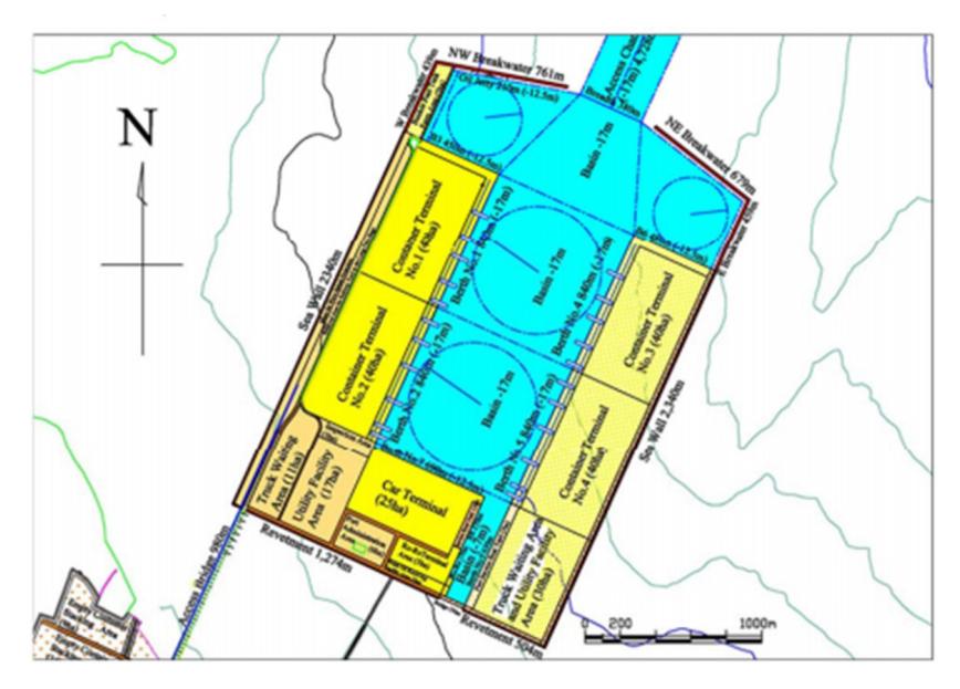
Figure 3 Design of Patimban Port (Japan International Cooperation Agency, 2017)
According to data from Japan International Cooperation Agency (JICA), the following is the largest vessel that will enter Patimban Port is the ULCS-class container ship (18000 TEUs) which has a length of 400 m, a width of 59 m, and a vessel draft of -16 m. Meanwhile, the largest car carrier expected to call at Patimban Port has a length of 232 m, a width of 32.26 m, and a draft of -11.4 m. These types of vessels are assumed to be the largest vessels that will frequently call into Patimban Port. Based on information published on the construction plan of Patimban Port, the navigation channel and the docking berth will both have a depth of -17 m. Meanwhile, the planned diameter of the rotary pool is 840 m, and the planned width of the shipping lane is 500 m.
Table I Vessel Dimensions
| Ship Type | LOA (m) | Width (m) | Draft (m) |
|---|---|---|---|
| Container | 400 | 59 | 16 |
| Car Transport | 232 | 32.26 | 11.4 |
(Source: Japan International Cooperation Agency, 2017)
The secure width of the dual-lane navigation channel is 7.6B, with B being the width of the widest possible vessel, which is 59 m. Therefore, it can be calculated that the width of the channel should be at least 448.4 m. The minimum diameter of the rotary pool needed for the ship to change the direction of the ship is at least the area of a circle with a radius of 1.5 times the length of the largest possible vessel. Therefore, it can be calculated that the minimum radius of the rotating pool required is 600 meters, or 1200 meters in diameter. In a rotary pool, if the change of course of the vessel is assisted by an anchor or using a tugboat, the minimum required radius is 400 m. The gross clearance space is used to determine the base nominal elevation of the navigation channel on the open sea. If a vessel that experiences large waves and it is still sailing relatively fast, the gross freedom space is 20% of the vessel's draft, which is worth 3.2 meters. In a scenario where the vessel is in a port pool that is sheltered from waves, the gross freedom space decreases to only 7% of the vessel's draft, which equals to 1.12 meters. Therefore, there needs to be an increase in depth of the navigation channels that are in the high seas by 3.2 meters, while there needs to be an additional depth of 1.12 meters in the area of the port pool that is protected from waves. As for car carriers, the required channel width is 245,176 m, and the minimum radius of the rotating pool is at 348 m, and further decreases to 232 m if a tugboat or anchors are there to assist the change of course. The requirement for gross freedom space in the high seas for car carriers is 2.28 m and 0.798 m in the port pool area. The table below summarizes the minimum dimensions of port-related measurements depending on vessel types.
Table II Comparison of Plans against Ship Types
| Vessel type | ||||
|---|---|---|---|---|
| Comparison | Plan | Reference Standards | Container | Car Transport |
| Pipeline Width | 500 m | 7.6*B (Two Lines) | 448.4 m | 245,176 m |
| Rotary Pool | 420 m | 1.5*LOA (Fingers) | 600 m | 348 m |
| Swivel Pool (Tugboat) | 420 m | LOA (Radius) | 400 m | 232 m |
| Room Gross Freedom | 20% Draft (High Seas) | 3.2 m | 2.28 m | |
| Room Gross Freedom | 7% Draft (Port Pool) | 1.12 m | 0.798 m | |
(Source: Japan International Cooperation Agency, 2017)
According to the calculation summarized in the table above, it can be inferred that the rotary pool at Patimban Port needs the help of tugboats to make changes of course for the vessels. Ships with a length of more than 280 m will certainly require the help of tugboats, while ships below can change courses independently. The depth in the shipping lane and port pool has a different gross freedom space because in the shipping lane, a sailing vessel is still exposed to waves from the high seas, as this is not the case for the port pool area where the sea waves will be restrained by the breakwater. The clearance figure needed to keep the vessel safe when entering the navigation channel is the vessel's draft added with gross freedom space and further added with sedimentary influence. The required depth without calculating the influence of sediment for the largest vessel is -16 m, coupled with an additional -3.2 m. Therefore, the total depth required is -19.2 m to provide a safe clearance for the vessel's draft.
There are also plans to construct a Ro-Ro docking facility in the inner part of the port for Ro-Ro services between Patimban and other locations in Indonesia. The dominant direction of the waves comes from the northeast, and the general alignment of the channel must be adjusted to avoid the reverse wave attacking the stern side of the vessels entering the port area. The volume of sediment in access channels and areas within the harbor is estimated to accumulate at a volume of 135,000 m3 per year and 26,000 m3 as per calculations done by using simulation models. The rate of sedimentation in the channel area is estimated to be about 135,000 m3 per year (7.8 cm per year), 26,000 m3 per year (1.1 cm per year) in the main basin area, and about 3,000 m3 per year the basin in areas between the Ro-Ro pier and the ship repair dock (2.8 cm/year)
Based on the data above, it can be calculated that the amount of sedimentation that occurs during the year is about 150,000 m3. Based on standards set by the Japanese authorities, in case of an increase of 0.5 m, it will usually take 5 years or more to perform maintenance. If the calculated figure is less than 3 cm, then the maintenance process can be done for more than 5 years. The seabed sediment dredging disposal area is located 15 km away from the port area at a depth of -20 m below the CD.
Anchoring Locations
The anchoring points in Patimban Port is located between the location of the navigation channels and the port pool. The depth of this location reaches -17 meters from the CD. The location of the anchor points in Patimban Port is shown in Figure 4.
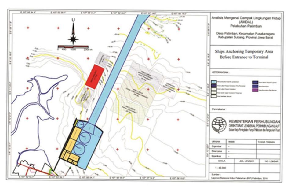
Figure 4 Planning for The Location of Anchoring in Patimban Port (Japan International Cooperation Agency, 2017)
The anchoring points in Patimban Port undergoes deposition which is estimated to reach 80 m3 per year taking into account all the influences of natural conditions around the port. Sediment sampling is carried out at several points in the vicinity. The location of sediment sampling is found in Figure 5.
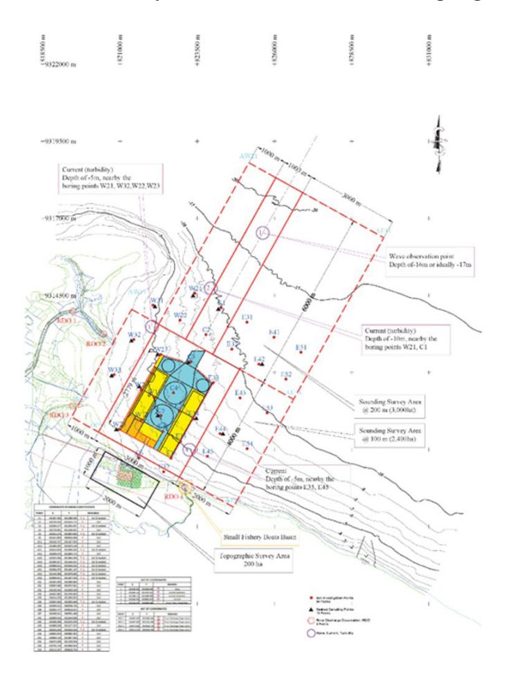
Figure 5. Sediment Sampling Location (Japan International Cooperation Agency, 2017)
Based on a survey conducted by the JICA survey team in 2016 at several sediment sampling sites, the results are summarized in Table 3 below.
Table III Characteristics of Patimban Port Seabed Sediment at the Sampling Site
| Location* | Depth (m) | Content Rate (%) | |||
|---|---|---|---|---|---|
| Gravel | Sand | Silt | Clay | ||
| C1 | 8.7 | 0.00 | 8.38 | 71.25 | 20.37 |
| C3 | 6.9 | 0.17 | 2.68 | 46.75 | 50.40 |
| C5 | 4.0 | 0.16 | 0.92 | 71.17 | 27.75 |
| E34 | 6.6 | 0.00 | 11.31 | 54.14 | 34.55 |
| E42 | 9.5 | 0.00 | 1.41 | 54.28 | 44.31 |
| E44 | 6.4 | 0.00 | 0.56 | 90.99 | 8.45 |
| W21 | 6.6 | 0.00 | 0.23 | 66.54 | 33.23 |
| W23 | 4.8 | 0.00 | 0.07 | 70.70 | 29.23 |
| W24 | 3.5 | 0.00 | 0.17 | 41.60 | 58.23 |
| W25 | 0.8 | 0.00 | 0.87 | 81.26 | 17.87 |
| W31 | 4.6 | 0.00 | 0.23 | 82.14 | 17.63 |
| W32 | 2.5 | 0.00 | 0.70 | 67.53 | 31.77 |
| W33 | 1.5 | 0.00 | 0.39 | 53.32 | 46.29 |
| Average | 0.03 | 2.15 | 65.51 | 32.31 | |
(Source: Japan International Cooperation Agency, 2017)
From the table above it is known that the sediment at the sampling site is dominated by silt. The results were in-line with what is stated in the relevant official document, which is the Indonesian Seabed Surface Sediment Map, which also declared silt as the major component that forms the sediment deposited around Patimban Port. Silt is 4 - 62 micrometers (Julien, 2010) in dimensions per particle. Silt belongs to a category of mud sedimentation that are smaller than 62.5 micrometers (Rifardi, 2008). Based on the type of sediment that has been acquired in this study, the location is suitable to be designated as an anchoring area because mud or sand becomes a good anchor retainer, because mud or sand eases the process of the anchor being implanted into the seabed (Maritime Safety Queensland, 2019). In addition to the anchoring locations, analysis of four data used to determine the anchorage area has been carried out and obtained anchorage locations that have the potential to become anchorage locations. Map of the proposed anchorage location can be seen in Figure 6.
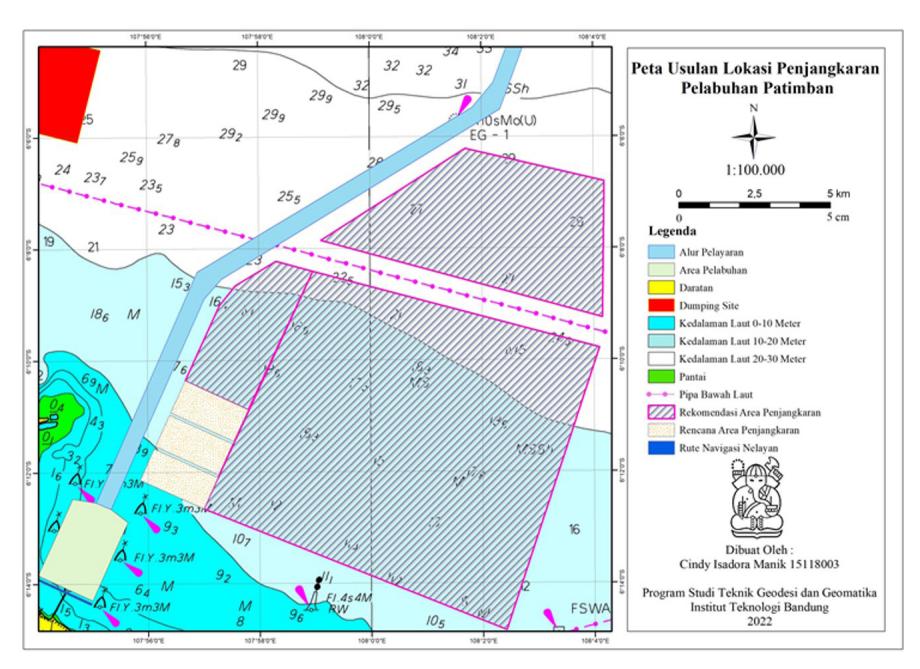
Figure 6 Proposed Map of Patimban Port Anchoring Location
Based on the analysis, the anchoring location is to the east of the port, so there is one anchorage location in the planned anchorage location by JICA that is not suitable. The anchorage location is also in the east because it considers the Cipunagara River which is the largest river around the Patimban Port and the existence of a dumping site or a dumping site for sediment dredging.
Responding to Sedimentation
The sedimentation phenomenon that occurs in Patimban Port is the responsibility of the Kantor Kesyahbandaran dan Otoritas Pelabuhan (KSOP), or Port Management Authorities of Patimban Port. The KSOP of Patimban Port is currently performing maintenance to ensure the safety of the existing navigation channels. The ongoing construction conditions of Patimban Port will have an impact on the depth of navigation channels. Based on interviews that has been conducted with representatives of the KSOP of Patimban Port, the current depth figures for the navigation channels and the port pool are around -10 m. Most of the vessels that are calling in Patimban Port have a draft of about -7 to -9 m. In the future there will be a further dredging of the seabed to increase the depth to -14 m in 2024, before finally being dredged to -17 m in the year of 2027. The conditions of the shipping lanes and the port pool are always monitored in a timely manner by the tugboats.
Policy Gaps between Planning and Implementation
Patimban Port in Subang Regency, is categorized as a Pelabuhan Utama (PU), or main/major port, with the designated code of KPU-PL-DLK-02 that are equipped with Alur Pelayaran dan/atau Perlintasan (AL-APP)-I-01 (navigation and crossing channels) which includes navigation channels that connect multiple ports with various international ports and hubs in Indonesia and overseas (West Java Provincial Government, 2019).
The planned navigation channels is expected to be under-optimalized due to it being overlapping with other sea-bound objects. Referring to the Coastal Areas Zoning Map of West Java Province, the Patimban Port's navigation channels are obstructed by underwater pipeline structures in two locations and are also overlapping in area with a Fisheries Catchment Area. Although the obstruction does not precisely coincide with the propsed anchoring location, there has been an overlap between the navigation channels and undersea pipeline installations.
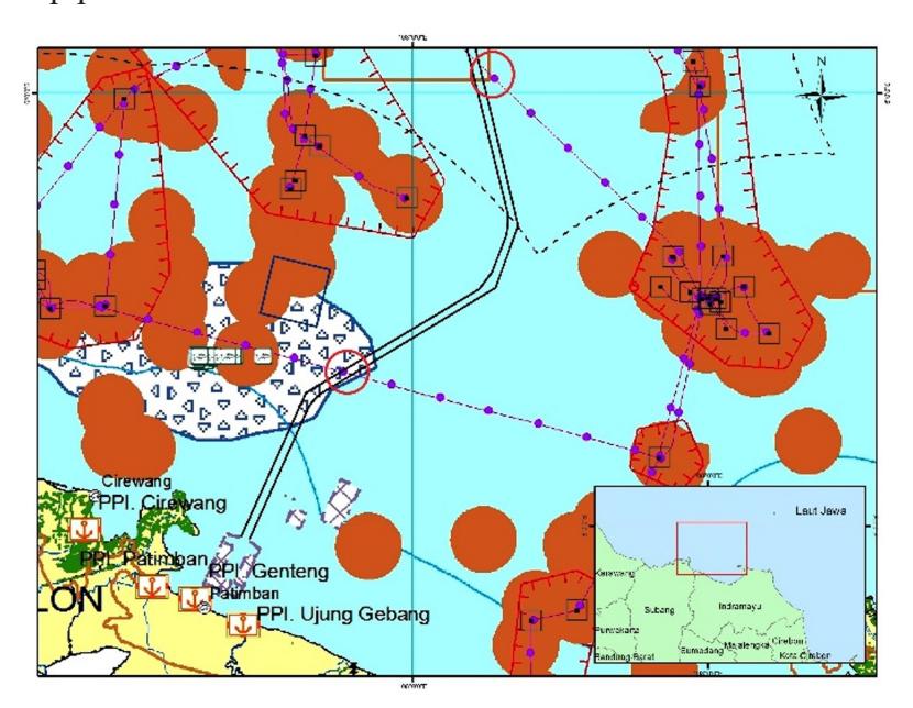
Figure 7 Overlapping Navigation Channels and Undersea Pipeline Installation (Japan International Cooperation Agency, 2017)
Impact of Port Development and Sedimentation on Fishermen
The construction process of Patimban Port has an impact on the communities around the port's construction site. The construction of the port is expected to stimulate economic development in the surrounding communities by tapping the resources such as available workforce and inducing trade and businesses to grow. However, in the case of the construction of Patimban Port, the projected economic benefits have yet to be reaped by the citizens of the nearby communities.
Environmental Impact
Instead, the effects of the port development that can be felt by the communities surrounding the port are largely negative impacts on environmental conditions, and the availability of fish that can be caught by fishermen. The construction of the breakwater structure creates a shift of the currents in the sea, where it also causes flooding in adjacent coastal areas. JICA has created a model of the currents at the time before and 5 years after the construction of the port. The modeling carried out also factors in the effect of changes in the direction of currents when there is a construction of a port structure. Based on the results of the modeling, the current speed is altered by about 2-3 cm/s. In the illustration that depicts the modeling process, the black arrow represents the pattern of currents before the construction, the red arrow depicts the pattern of currents after the port has been constructed, meanwhile, the part that has various colors shaded onto it shows the speed of the current. The following image compares and shows the results of current modeling between the monsoon and dry seasons.
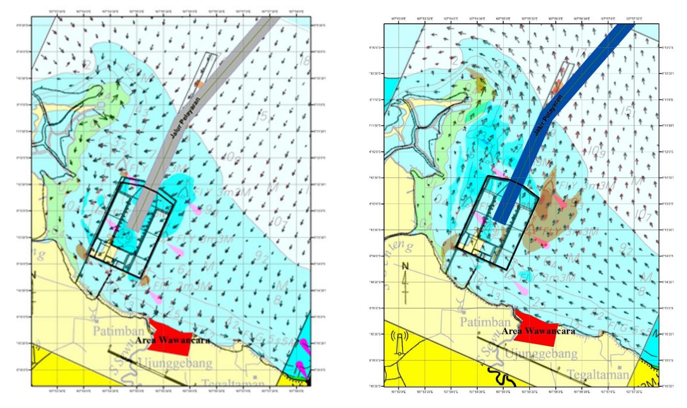
Figure 8 Results of Current Modeling in the Monsoon Season
Figure 9 Results of Current Modeling in the Dry Season
The result of the modeling shows that the movement patterns of the current underwent a significant shift since the construction of the port. The changing directions of the currents are the cause of flooding in coastal areas because the currents now draw a significant amount of water into a certain target point.
Another impact that is bourne by the local fishermen community is the reduced number of fish that can be caught in the sea around Patimban Port. This is due to the fish prefering locations further towards the sea to avoid the development of port infrastructure that is being carried out. This condition forces the fishermen to go the extra mile to capture fish further offshore with uncertain yields due to the changes in fish behavior since the construction of the port.
Social and Economic Impact
Patimban Port is intended as a buffer for industrial product distribution activities that have begun to be crowded at Tanjung Priok Port. In particular, Patimban Port is used for car export activities. The position of Patimban Port is quite strategic in supporting the results of the car industry located in West Java Province. The distribution of the location of the car industry in West Java Province is shown in Figure 10.
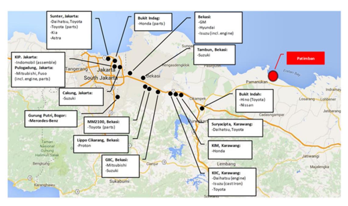
Figure 10 Location of Various Factories and Plants owned by Automobile Manufacturers in West Java
In terms of socio-economic changes, there has been a shift in the pattern of social interaction of the citizens that live surrounding Patimban Port. The residents are initially used to minimal interaction between each other and live in a sparsely populated area. Since the operation of the port, the area has now become more crowded, along with the shift in the local economy from what is previously mainly relies on the agricultural and marine fishery sector, has now shifted to mostly rely on the industrial sector.
This has caused a rapid shift in the jobs and occupations of the people in the neighboring communities of the port. The agricultural sector of the area experiences a rapid decline in the workforce that is employed in the sector, due to the more rice fields that are being converted into industrial hubs and facilities. The fishery sector is also losing its popularity as a means of living for residents due to the increased difficulty of catching fish offshore that is caused by the changing behavior of the fishes, which is ultimately caused by the construction and operation of the port. The mobility of certain members of a community can occur by the will and regulation of the government, by the own will of the community, or as a result of external influences and interdependencies (Iryana, 2018). Figure 11 below illustrates the patches of land that are cleared to support the construction of Patimban Port.
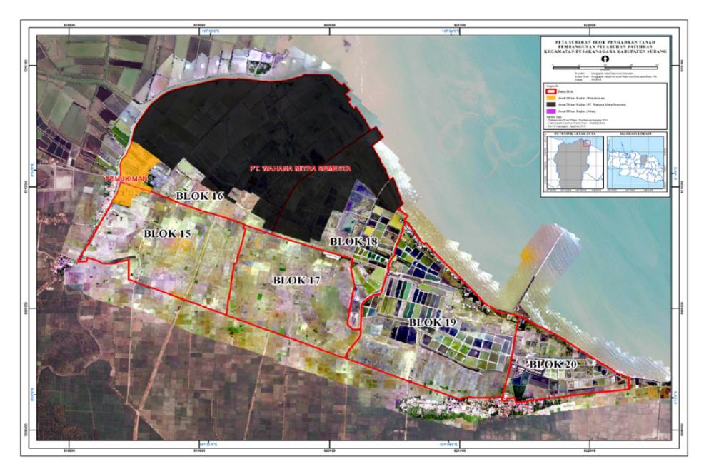
Figure 11. Patches of Land that are Procured for the Construction of Patimban Port
For the remaining farmers whose land are not cleared to make way for the construction of the port, the negative impact that is bourne by them is the increased scarecity of water that is needed to irrigate the land. This shows that such a development may have both positive and negative impacts to the local community. The youth of the local surrounding communities will benefit by the many available job openings as a result of the construction of the port, in conjunction with the establishment of many companies that are needed to support the industrial activities nearby the Patimban Port area (Iryana, 2018).
Data Integration in Information Systems
Natural phenomena that alter the physical aspects of nature need to be accommodated by providing fast and accurate information, both for authorities that manage and the parties that use Patimban Port. The use of internet services has become absolutely necessary, not only to provide information regarding the traffic of incoming and outgoing vessels, but also related to information on physical conditions of the nature that affects the daily activities of the port.
Industrial Revolution 4.0 offers a solution for problems often encountered in practices of port governance and to improve the overall efficiency of port operations. Research in the field of ports, shipping, and logistics that relate to the Industrial Revolution 4.0 include aspects such as:
- 1. Automation in waiting time reduction
- 2. Use of big data in port management
- 3. IT-based services that cater to the needs of users
- 4. Overall improvement in the currently existing system
- 5. Enablement of internet in all existing services
- 6. The deployment of Vessel Traffic Management System (VTMS) to direct the movement of vessels in the port
With the rapidly improving practices of port development, being up to date with the newest technological improvements is important to cater to the growth and expansion of the community surrounding the port.
Conclusion
A system that monitors the real-time conditions of the port and its surrounding areas that are based on 4.0 Industrial Revolution will provide quick and accurate information related to the sedimentation that occurs around the port. This information system will assist port managers in formulating appropriate strategies in response to sediment buildup that settle in the waters of the port and take into account the considerations that are needed to quickly respond to such events. Physical changes that occur in the port can be monitored with technology.
Acknowledgment
We would like to thank the Faculty of Earth Science and Technology, Bandung Institute of Technology for providing this research funding. We appreciate our colleagues Nafandra Syabana Lubis, provided insight and expertise that greatly assisted the research.
References
- Abdurrahman, U., Park, H., & Suprijo, T. (2020). Study of shoreline evolution under the influence of jetty construction : A case study of Karangsong Study of shoreline evolution under the influence of jetty construction : A case study of Karangsong Beach , Indramayu , Indonesia. IOP Conf. Series: Earth and Environmental Science 698 (2021) 012038, 0–12. https://doi.org/10.1088/1755- 1315/698/1/012038
- Bahri, S., Abrar, A. I. P., & Angriani, A. D. (2017). PERBANDINGAN METODE DEDUKTIF DENGAN INDUKTIF TERHADAP HASIL BELAJAR MATEMATIKA DITINJAU DARI MOTIVASI BELAJAR SISWA. 5(2), 201–215. https://doi.org/10.24252/mapan.v5n2a4
- Bosa, S., Petti, M., & Pascolo, S. (2021). Improvement in the Sediment Management of a Lagoon Harbor : Water (Switzerland), 13(3074). https://doi.org/https:// doi.org/10.3390/w13213074
- Dinas Pekerjaan Umum. (2005). Perencanaan jeti tipe rubble mound untuk penanggulangan penutupan muara sungai oleh sedimen (Vol. 3). http://sni.litbang.pu.go.id/image/sni/isi/pd-t-02-2005-a.pdf
- Hartman, M. A., Ph, D., Asce, A. M., Mitchell, K. N., Ph, D., Dunkin, L. M., Lewis, J., Ph, D., Emery, B., Lenssen, N. F., Copeland, R., Ph, D., & Asce, M. (2022). Southwest Pass Sedimentation and Dredging Data Analysis. 148(2), 1–8. https://doi.org/10.1061/(ASCE)WW.1943-5460.0000684
- Iryana, A. B. (2018). Analisis Dampak Pembangunan Pelabuhan Patimban Di Kecamatan Pusakanegara Terhadap Kondisi Sosial Ekonomi Masyarakat Sekitar. Jurnal Caraka Prabu, 2(1), 21–40. https:// doi.org/10.36859/jcp.v2i1.398
- Janssen, M. S., Asce, S. M., Lemke, L., Asce, S. M., Miller, J. K., Asce, M., & Douglas, W. S. (2022). Fortescue Inlet : Offshore Deposition Basins for Navigation Channel Management in Small Craft Inlets. 148(2), 1–17. https://doi.org/10.1061/(ASCE)WW.1943-5460.0000689
- Japan International Cooperation Agency. (2017). The Preparatory Survey on Patimban Port Development Project in the Republic of Indonesia. 5, 17–65.
- Kramadibrata, S. (2002). Perencanaaan Pelabuhan. Penerbit ITB.
- Kirichek, A., Rutgers, R., Wensween, M., & van Hassent, A. (2018). Sediment management in the Port of Rotterdam. 2(June 2018), 8.
- Maritime Safety Queensland. (2019). Anchorage Area Design and Management Guideline. In Maritime Safety Queensland. Department of Transport and Main Roads. http://creativecommons.org. licences/by/4.0/
- Maryanto, A. (2013). KEEFEKTIFAN STRATEGI INDUKTIF DAN STRATEGI DEDUKTIF DALAM PEMBELAJARAN IPA UNTUK MENINGKATKAN PRESTASI BELAJAR DAN MOTIVASI BELAJAR IPA SISWA SMP. UNIVERSITAS NEGERI YOGYAKARTA.
- Pemerintah Indonesia. (2016). Peraturan Pemerintah Nomor 47 tahun 2016 tentang Penetapan Pelabuhan Patimban di Kabupaten Subang sebagai Proyek Strategis Nasional (Peraturan Pemerintah Nomor 47 tahun 2016).
- Pemerintah Provinsi Jawa Barat. (2019). Peraturan Daerah Provinsi Jawa Barat Nomor 5 Tahun 2019 tentang Rencana Zonasi Wilayah Pesisir dan Pulau-Pulau Kecil Provinsi Jawa Barat Tahun 2019- 2039 (Peraturan Daerah Provinsi Jawa Barat Nomor 5 Tahun 2019).
- PT Pelabuhan Indonesia II. (2019). Laporan Tahunan 2019.
- Sarma, K. G. S. (2015). Siltation and coastal erosion at shoreline harbours. Procedia Engineering, 116(1), 12–19. https://doi.org/10.1016/j.proeng.2015.08.259
- Triatmodjo, B. (2009). Perencanaan Pelabuhan. Beta Offset Yogyakarta.